- National Register of Historic Places listings in Texas, Counties H-J
-
The following is a list of places within the state of Texas that are listed in the National Register of Historic Places. The names on the list are as they were entered in the register; some place names are inaccurate or have changed since being added.
These are intended to be complete lists of properties and districts listed on the National Register of Historic Places in each of the Texas counties covered. The locations of National Register properties and districts (at least for all showing latitude and longitude coordinates below) may be seen in a Google map by clicking on "Map of all coordinates".[1]
Contents: Counties A-C · Counties D-G · Counties H-J · Counties K-S · Counties T-Z
(links in italic lead to a new page)Hale - Hall - Hamilton - Hardeman - Hardin - Harris - Harrison - Hartley - Hays - Hemphill - Henderson - Hidalgo - Hill - Hood - Hopkins - Houston - Howard - Hudspeth - Hunt - Hutchinson - Irion - Jack - Jackson - Jasper - Jeff Davis - Jefferson - Jim Wells - Johnson - Jones
-
- This National Park Service list is complete through NPS recent listings posted November 10, 2011.[2]
Hale County
[3] Landmark name [4] Image Date listed Location City or town Summary 1 Plainview Commercial Historic District December 2, 1982 Roughly bounded by E. 4th, Austin, E. 9th, and Ash Sts. (both sides) Plainview 2 Plainview Site October 15, 1966 Address Restricted Plainview Hall County
[3] Landmark name Image Date listed Location City or town Summary 1 Hall County Courthouse 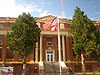
October 1, 2008 512 W. Main
34°43′31.03″N 100°32′6.35″W / 34.7252861°N 100.5350972°WMemphis Ref. #08000961 2 Hotel Turkey October 24, 1991 Jct. of 3rd and Alexander Sts.
34°23′38″N 100°53′51″W / 34.39389°N 100.8975°WTurkey Ref. #91001521 Hamilton County
[3] Landmark name Image Date listed Location City or town Summary 1 Hamilton County Courthouse 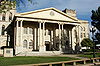
September 4, 1980 Public Sq.
31°42′13″N 98°7′23″W / 31.70361°N 98.12306°WHamilton Hardeman County
[3] Landmark name Image Date listed Location City or town Summary 1 Quanah Commercial Historic District May 25, 2000 Roughly bounded by Green, Second, Third, Fourth, Fifth, King, Elbert, and McClelland Sts., and Burlington Northern RR tr Quanah 2 Quanah, Acme and Pacific Railway Depot October 15, 1979 100 Mercer St.
34°17′14″N 99°44′52″W / 34.28722°N 99.74778°WQuanah Hardin County
[3] Landmark name Image Date listed Location City or town Summary 1 Ada Belle Oil Well January 20, 1980 N of Batson
30°15′49″N 94°36′57″W / 30.26361°N 94.61583°WBatson 2 Kirby-Hill House May 20, 1999 210 Main St.
30°22′12″N 94°18′55″W / 30.37°N 94.31528°WKountze Harris County
Harrison County
Hartley County
[3] Landmark name Image Date listed Location City or town Summary 1 Hartley County Courthouse and Jail 
December 31, 1987 Railroad Ave.
35°40′54″N 102°19′57″W / 35.68167°N 102.3325°WChanning 2 Proctor Pen I(41HT13) July 12, 1984 Address Restricted Amarillo 3 Miguel Tafoya Place(41HT17) July 12, 1984 Address Restricted Amarillo 4 XIT General Office May 6, 1985 Railroad Ave. and 5th St.
35°41′9″N 102°19′52″W / 35.68583°N 102.33111°WChanning Hays County
Main article: List of Registered Historic Places in Hays County, TexasHemphill County
[3] Landmark name Image Date listed Location City or town Summary 1 Battle of Lyman's Wagon Train August 13, 2001 Address Restricted Canadian Henderson County
[3] Landmark name Image Date listed Location City or town Summary 1 Faulk and Gauntt Building June 9, 1980 217 N. Prairieville St.
32°12′21″N 95°51′19″W / 32.20583°N 95.85528°WAthens Hidalgo County
Hill County
Hood County
[3] Landmark name Image Date listed Location City or town Summary 1 Baker-Carmichael House December 6, 2005 226 E. Pearl St.
32°26′32″N 97°47′8″W / 32.44222°N 97.78556°WGranbury 2 Hood County Courthouse Historic District 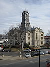
June 5, 1974 Courthouse Sq., bounded by Bridge, Pearl, and Houston Sts.
32°26′33″N 97°47′13″W / 32.4425°N 97.78694°WGranbury 3 Wright-Henderson-Duncan House December 19, 1978 703 Spring St.
32°26′7″N 97°47′41″W / 32.43528°N 97.79472°WGranbury Hopkins County
[3] Landmark name Image Date listed Location City or town Summary 1 Hopkins County Courthouse 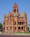
April 11, 1977 Church and Jefferson Sts.
33°8′18″N 95°36′2″W / 33.13833°N 95.60056°WSulphur Springs Houston County
[3] Landmark name Image Date listed Location City or town Summary 1 Downes-Aldrich House April 19, 1978 206 N. 7th St.
31°19′10″N 95°27′16″W / 31.31944°N 95.45444°WCrockett 2 First United Methodist Church March 21, 2011 701 E Goliad Ave
31°19′3″N 95°27′17.25″W / 31.3175°N 95.4547917°WCrockett 3 Houston County Courthouse 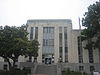
May 10, 2010 401 E Houston Ave.
31°19′5″N 95°27′27″W / 31.31806°N 95.4575°WCrockett 4 Mary Allen Seminary for Colored Girls, Administration Building May 12, 1983 803 N. 4th St.
31°19′38″N 95°27′41″W / 31.32722°N 95.46139°WCrockett 5 Monroe-Crook House March 31, 1971 707 E. Houston St.
31°19′8″N 95°27′15″W / 31.31889°N 95.45417°WCrockett 6 Westerman Mound June 21, 1971 Address Restricted Kennard Howard County
[3] Landmark name Image Date listed Location City or town Summary 1 Potton-Hayden House April 14, 1975 SW corner Gregg and 2nd Sts.
32°15′8″N 101°28′47″W / 32.25222°N 101.47972°WBig Spring Hudspeth County
Hunt County
[3] Landmark name Image Date listed Location City or town Summary 1 William and Medora Camp House November 14, 1988 2620 Church St.
33°8′34″N 96°6′27″W / 33.14278°N 96.1075°WGreenville 2 Central Christian Church January 6, 2004 2611 Wesley St.
33°8′19″N 96°6′30″W / 33.13861°N 96.10833°WGreenville 3 Hunt County Courthouse 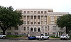
June 21, 1996 2500 Lee St.
33°8′22″N 96°6′23″W / 33.13944°N 96.10639°WGreenville 4 Katy Depot January 25, 1997 3102 Lee St.
33°8′25″N 96°6′44″W / 33.14028°N 96.11222°WGreenville 5 Post Office Building August 7, 1974 Lee at King St.
33°8′24″N 96°6′39″W / 33.14°N 96.11083°WGreenville 6 President's House November 21, 2001 SW of Circle Dr., N of Stonewall St., bet. Campbell and Bois D'Arc Sts.
33°14′33″N 95°54′18″W / 33.2425°N 95.905°WCommerce 7 Washington Hotel November 27, 2010 2612 Washington Street
33°8′21.25″N 96°6′28.25″W / 33.1392361°N 96.1078472°WGreenville Former listings
[3] Landmark name Image Date listed Location City or town Summary 1 Blanton School June 3, 2009 610 E Witt St.
33°22′7″N 96°4′3″W / 33.36861°N 96.0675°WWolfe City Torn down August 7, 2008 [5], listed 9/12/2006 2 Mayo Hall October 12, 2010 Monroe and Stonewall Sts.
33°14′33″N 95°54′11.75″W / 33.2425°N 95.9032639°WCommerce Listed July 31, 2003. Delisted after being torn down. Hutchinson County
[3] Landmark name Image Date listed Location City or town Summary 1 Adobe Walls May 22, 1978 Address Restricted Stinnet 2 Antelope Creek Archeological District September 22, 1972 Address Restricted Fritch Irion County
[3] Landmark name Image Date listed Location City or town Summary 1 Former Irion County Courthouse 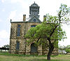
August 29, 1977 Public Sq.
31°16′47″N 100°47′41″W / 31.27972°N 100.79472°WSherwood Jack County
[3] Landmark name Image Date listed Location City or town Summary 1 Fort Richardson 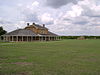
October 15, 1966 S of Jacksboro on U.S. 281
33°12′25″N 98°9′50″W / 33.20694°N 98.16389°WJacksboro Established 1867; abandoned 1878; renovated and reopened 1973 as historic park. Jackson County
[3] Landmark name Image Date listed Location City or town Summary 1 Archeological Site No. 41JK9 August 19, 1994 Address Restricted Lolita 2 Edna Theatre 
September 8, 2011 201 West Main Street
28°58′41.25″N 96°38′51.75″W / 28.978125°N 96.6477083°WEdna 3 Texana Presbyterian Church September 12, 1979 Apollo Dr. and Country Club Lane
28°57′53″N 96°39′20″W / 28.96472°N 96.65556°WEdna Jasper County
[3] Landmark name Image Date listed Location City or town Summary 1 Aldridge Sawmill March 2, 2001 Angelina National Forest., S end of Forest System Rd.
31°2′19″N 94°16′49″W / 31.03861°N 94.28028°WZavalla 2 Blake-Beaty-Orton House April 16, 1975 206 S. Main St.
30°55′8″N 93°59′58″W / 30.91889°N 93.99944°WJasper 3 Col. Randolph C. Doom House December 30, 1975 7.5 mi (12.1 km). W of Jasper on FM 1747
30°55′25″N 94°7′27″W / 30.92361°N 94.12417°WJasper 4 Jasper County Courthouse September 6, 1984 Public Sq.
30°55′16″N 94°00′00″W / 30.92111°N 94°WJasper 5 Andrew Smyth House May 25, 1979 W of Jasper
30°56′7″N 94°8′39″W / 30.93528°N 94.14417°WJasper 6 Turner-White-McGee House June 19, 1979 Off U.S. 96
30°48′17″N 93°54′51″W / 30.80472°N 93.91417°WRoganville 7 US 190 Bridge at the Neches River October 10, 1996 US 190 at the Jasper and Tyler Cnty. line
30°51′9″N 94°10′52″W / 30.8525°N 94.18111°WJasper Jeff Davis County
[3] Landmark name Image Date listed Location City or town Summary 1 Fort Davis National Historic Site 
October 15, 1966 Jct. of TX 17 and 118
30°35′55″N 103°53′40″W / 30.59861°N 103.89444°WFort Davis 2 Grierson-Sproul House August 11, 1982 Court Ave.
30°35′26″N 103°54′17″W / 30.59056°N 103.90472°WFort Davis 3 Jeff Davis County Courthouse July 11, 2002 Bounded by Court St., Front St., Woodward Ave., and State St.
30°35′18″N 103°53′42″W / 30.58833°N 103.895°WFort Davis 4 Phantom Lake Spring Site May 10, 1995 Address Restricted Toyahvale 5 Henry M. and Annie V. Trueheart House September 12, 1996 Jct. of 7th St. and Court Ave.
30°35′20″N 103°54′8″W / 30.58889°N 103.90222°WFort Davis Jefferson County
Jim Wells County
[3] Landmark name Image Date listed Location City or town Summary 1 Hinojosa Site March 30, 1978 Address Restricted Alice Johnson County
[3] Landmark name Image Date listed Location City or town Summary 1 Cleburne Carnegie Library 
December 12, 1976 201 N. Caddo St.
32°20′54″N 97°23′11″W / 32.34833°N 97.38639°WCleburne Ref. #76002042 2 Ham Creek Site February 15, 1974 Address Restricted Rio Vista Ref. #74002082 3 Meredith Hart House April 13, 1977 E of Rio Vista on SR 916
32°14′20″N 97°21′27″W / 32.23889°N 97.3575°WRio Vista Ref. #77001456 4 Johnson County Courthouse 
April 14, 1988 1 Public Sq.
32°20′50″N 97°23′10″W / 32.34722°N 97.38611°WCleburne Ref. #88000439 5 Joiner-Long House 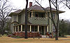
June 23, 2003 604 Prairie Av.
32°20′23″N 97°23′29″W / 32.33972°N 97.39139°WCleburne Ref. #3000558 6 Smith Ranch April 3, 2007 FM 916, 1 mi (1.6 km). W of TX 174 Rio Vista Ref. #7000271 7 Wright Building March 17, 2009 1 East James Street
32°20′47″N 97°23′9.5″W / 32.34639°N 97.385972°WCleburne Ref. #09000139 Jones County
See also
References
- ^ The latitude and longitude information provided in this table was derived originally from the National Register Information System, which has been found to be fairly accurate for about 99% of listings. For about 1% of NRIS original coordinates, experience has shown that one or both coordinates are typos or otherwise extremely far off; some corrections may have been made. A more subtle problem causes many locations to be off by up to 150 yards, depending on location in the country: most NRIS coordinates were derived from tracing out latitude and longitudes off of USGS topographical quadrant maps created under the North American Datum of 1927, which differs from the current, highly accurate WGS84 GPS system used by Google maps. Chicago is about right, but NRIS longitudes in Washington are higher by about 4.5 seconds, and are lower by about 2.0 seconds in Maine. Latitudes differ by about 1.0 second in Florida. Some locations in this table may have been corrected to current GPS standards.
- ^ "National Register of Historic Places: Weekly List Actions". National Park Service, United States Department of the Interior. Retrieved on November 10, 2011.
- ^ a b Numbers represent an ordering by significant words. Various colorings, defined here, differentiate National Historic Landmark sites and National Register of Historic Places Districts from other NRHP buildings, structures, sites or objects.
- ^ "National Register Information System". National Register of Historic Places. National Park Service. . http://nrhp.focus.nps.gov/natreg/docs/All_Data.html.
- ^ http://www.telehobbies.com/PGR/WC,%20PAGE%201,%208-14-2008.pdf
U.S. National Register of Historic Places Topics Lists by states Alabama • Alaska • Arizona • Arkansas • California • Colorado • Connecticut • Delaware • Florida • Georgia • Hawaii • Idaho • Illinois • Indiana • Iowa • Kansas • Kentucky • Louisiana • Maine • Maryland • Massachusetts • Michigan • Minnesota • Mississippi • Missouri • Montana • Nebraska • Nevada • New Hampshire • New Jersey • New Mexico • New York • North Carolina • North Dakota • Ohio • Oklahoma • Oregon • Pennsylvania • Rhode Island • South Carolina • South Dakota • Tennessee • Texas • Utah • Vermont • Virginia • Washington • West Virginia • Wisconsin • WyomingLists by territories Lists by associated states Other Categories:- National Register of Historic Places in Texas
-


Wikimedia Foundation. 2010.