- Chewton Keynsham
-
Coordinates: 51°23′44″N 2°29′58″W / 51.3955°N 2.4995°W
Chewton Keynsham 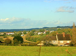
North from Fairy Hill, looking toward Chewton Keynsham and Keynsham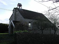
Mission Church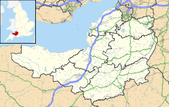
 Chewton Keynsham
Chewton Keynsham shown within SomersetPopulation approx. 100 OS grid reference ST652664 Unitary authority Bath and North East Somerset Ceremonial county Somerset Region South West Country England Sovereign state United Kingdom Post town BRISTOL Postcode district BS40 Dialling code 01761 Police Avon and Somerset Fire Avon Ambulance Great Western EU Parliament South West England UK Parliament North East Somerset List of places: UK • England • Somerset Chewton Keynsham (grid reference ST652664) is a small village on the River Chew in the Chew Valley, Somerset. It is 7 miles from Bristol, 7 miles from Bath, and 2 miles from Keynsham.
The village lies on the Monarch's Way long distance footpath.
Contents
Government and politics
Chewton Keynsham is part of the Farmborough Ward which is represented by one councillor on the Bath and North East Somerset Unitary Authority which has wider responsibilities for services such as education, refuse, tourism etc. The village is a part of the North East Somerset constituency and part of the South West England constituency of the European Parliament.
Demographics
According to the 2001 Census, the Farmborough Ward (which includes Woollard and Compton Dando), had 1,111 residents, living in 428 households, with an average age of 44.5 years. Of these 71% of residents describing their health as 'good', 21% of 16-74 year olds had no qualifications; and the area had an unemployment rate of 1.0% of all economically active people aged 16-74. In the Index of Multiple Deprivation 2004, it was ranked at 22,100 out of 32,482 wards in England, where 1 was the most deprived LSOA and 32,482 the least deprived.[1]
Chewton Place
Chewton Place is a Grade II listed building was formerly a large detached house, but is now used as a conference centre. It was built about 1762 and extended c. 1786. It was extensively remodelled in 1860–70 and restored in 1968 after flood damage and further extended in 1987–88. (Chewton Place at Images of England) A folly tower, known locally as the Owl Tower, was built in the grounds in the late 18th century. It is a tall tapering square obelisk of coursed limestone. It has pointed-arched openings to east and west sides, producing a walk-through passage at ground floor level. There are diagonal buttresses with set-offs and small pointed-arched openings on each face and pyramidal cap. The carved owl to keystone on arched opening, probably gives the folly its name. The folly is also a Grade II listed building.
References
- ^ "Neighbourhood Statistics LSOA Bath and North East Somerset 016B Farmborough". Office of National Statistics 2001 Census. http://neighbourhood.statistics.gov.uk/dissemination/LeadProfileSearch.do?profileSearchText=BS39+4LW&searchProfiles=. Retrieved 2006-05-01.
External links
- Chew Valley website
- River Chew website
- Folly approx. 15 m to west of Chewton Place at Images of England
Chew Valley Villages: Belluton · Bishop Sutton · Blagdon · Burnett · Cameley · Camerton · Chelwood · Chew Magna · Chew Stoke · Chewton Keynsham · Chewton Mendip · Clutton · Compton Dando · Compton Martin · East Harptree · High Littleton · Hinton Blewett · Hunstrete · Keynsham · Litton · Marksbury · Nempnett Thrubwell · Norton Malreward · Pensford · Publow · Regil · Stanton Drew · Stanton Prior · Stowey · Temple Cloud · Timsbury · Ubley · West Harptree · Winford · WoollardReservoirs: Rivers: SSSIs: Open Access Land Councils: Surrounding areas: Categories:- Villages in Bath and North East Somerset
- Monarch's Way


Wikimedia Foundation. 2010.