- Manaslu
-
Manaslu 
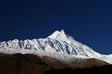
Manaslu at sunriseElevation 8,156 m (26,759 ft)
Ranked 8thProminence 3,092 m (10,144 ft) Listing Eight-thousander
UltraTranslation Mountain of the Spirit (Sanskrit) Location Nepal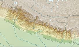
 Manaslu
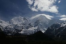
Range Mansiri Himal, Himalayas Coordinates 28°33′0″N 84°33′35″E / 28.55°N 84.55972°ECoordinates: 28°33′0″N 84°33′35″E / 28.55°N 84.55972°E Climbing First ascent May 9, 1956 by a Japanese team Easiest route snow/ice climb Manaslu (Nepali: मनास्लु), also known as Kutang) is the eighth highest mountain in the world, and is located in the Mansiri Himal, part of the Nepalese Himalayas, in the west-central part of Nepal. Its name, which means "Mountain of the Spirit", comes from the Sanskrit word Manasa, meaning "intellect" or "soul". Manaslu was first climbed on May 9, 1956 by Toshio Imanishi and Gyalzen Norbu, members of a Japanese expedition. It is said that "just as the British consider Everest their mountain, Manaslu has always been a Japanese mountain".[1][2][3][4]
Manaslu at 8,156 metres (26,759 ft) above mean sea level (m.s.l) is the highest peak in the Lamjung District and is located about forty miles east of Annapurna. The mountain's long ridges and valley glaciers offer feasible approaches from all directions, and culminate in a peak that towers steeply above its surrounding landscape, and is a dominant feature when viewed from afar.[3][4][5]
The Manaslu region offers a variety of trekking options. The popular Manaslu trekking route of 177 kilometres (110 mi), skirts the Manaslu massif over the pass down to Annapurna. The Nepalese Government only permitted trekking of this circuit in 1991. The trekking trail follows an ancient salt-trading route along the Budhi Gandaki river. Enroute, 10 peaks over 6,500 metres (21,300 ft) are visible, including a few over 7,000 metres (23,000 ft). The highest point reached along the trek route is the Larkya La at an elevation of 5,235 metres (17,175 ft). As of May 2008, the mountain has been climbed 297 times with 53 fatalities.[1][3][6][7]
Manaslu Conservation Area has been established with the primary objective of achieving conservation and sustainable management of the delimited area, which includes Manaslu.[8]
Contents
General
Set in the northern Himalayan range in the Gorkha land of Nepal, Manaslu is a serrated "wall of snow and ice hanging in the sky".[citation needed] The three sides of the mountain fall in steps to terraces down below, which are sparsely inhabited with agricultural operations practiced on the land. Apart from climbing Manaslu, trekking is popular in this mountain region, as part of the Manaslu Circuit, a notable path by trekkers in Nepal.[3]
The Manaslu Conservation Area, declared as such in December 1998 under the National Parks and Wild Life Conservation Act, subsumes Manaslu within it. The area covered under the conservation zone is 1,663 square kilometres (642 sq mi) and is managed by the National Trust for Nature Conservation (NTNC) of Nepal. The status of "conservation area" applied to the Manaslu area or region was with the basic objective "To conserve and sustainable management of the natural resources and rich cultural heritage and to promote ecotourism to improve livelihood of the local people in the MCA region."[8]
Manaslu Himal, as it is popularly known among trekkers, provides views of the snow-covered mountains of the Himalayas and allows close interaction with the different ethnic groups who live in hill villages scattered along the trek route.[9]
The trekking route is through mountains prone to the consequences of monsoon rainfall, land slides and land falls. Encounters with passing yaks, and hypothermia and altitude sickness, are common. Trekking to Manaslu is thus a test of endurance.[10]
Geography

The region, which is also termed the Manaslu Conservation Area, comprises sub-tropical Himalayan foothills to arid Trans-Himalayan high pastures bordering Tibet. Starting from Arughat and extending into the Larkhe La pass, the area covers six climatic zones: the tropical and sub-tropical zone, elevation varies from 1,000–2,000 metres (3,300–6,600 ft); the temperate zone (within elevation range of 2,000–3,000 metres (6,600–9,800 ft); the sub-alpine zone elevation range of 3,000–4,000 metres (9,800–13,000 ft); the alpine zone, a range of 4,000–5,000 metres (13,000–16,000 ft)) meadows; and the arctic zone (lying above 4,500 metres (14,800 ft)). The zones coalesce with the variation of the altitude from about 600 metres (2,000 ft) in the tropical zone to the 8,156 metres (26,759 ft) summit of Manaslu in the arctic zone.[4][7][11][12]
Manaslu is known in the Tibetan language as "Kutan l", in which "tang" means the Tibetan word for a flat place. It is a very large peak with an elevation of 8,156 metres (26,759 ft) (the world’s eighth highest mountain). In view of its favourable topography of long ridges and glacial valleys, Manaslu offers several routes to mountaineers. Important peaks surrounding Manaslu include Ngadi Chuli, Himalchuli and Baudha. A glacial saddle known as Larkya La, with an elevation of 5,213 metres (17,103 ft), lies across the Nepal–Tibet border. The peak is bounded on the east by the Ganesh Himal and the Buri Gandaki River gorge, on the west by the deep fissures of the Marysyangdi Khola with its Annapurna range of hills, to the south is the Gorkha town at the foot of the hill (from where trekking operates during the season), which is an aerial distance of 48 kilometres (30 mi) to the peak. There are six established trek routes to the peak, and on the mountain the south face is reportedly the most difficult for climbing.[4][7][11]
- Climate
The permanent snow line is reckoned above 5,000 metres (16,000 ft) elevation. Precipitation in the area is both from snowfall and rainfall; the average annual rainfall is about 1,900 millimetres (75 in) mostly during the monsoon period, which extends from June to September. The temperatures in the area also vary widely with the climatic zone: in the subtropical zone, the average summer and winter temperatures vary in the range of 31–34 °C (88–93 °F) and 8–13 °C (46–55 °F) respectively; in the temperate climatic zone, the summer temperatures are 22–25 °C (72–77 °F) and winter temperatures are -2–6 °C (28–43 °F) when snow and frost are also experienced; in the subalpine zone, during December to May snowfall generally occurs and the mean annual temperature is 6–10 °C (43–50 °F). The arctic zone is distinct and falls within the permanent snow line; there, the temperatures lie much below freezing zone.[12]
- Fauna
Unlike many other regions, this valley is a sanctuary to many highly endangered animals, including Snow Leopards and Pandas. Over 110 species of birds, 33 mammals, 11 butterflies and 3 reptiles have been recorded.[7][12][13] Conservation of wild life in the area has been achieved by monks of the monasteries in the area by putting a hunting ban in place. This action has helped the wildlife to prosper. The area is now an important habitat for the snow leopard, grey wolf, musk deer, blue sheep and the Himalayan Thar.[8]
- Vegetation
Three main categories of vegetation have been identified in the area. These are categorised on the basis of the altitude as Low hill, Middle mountain and High mountain types with its exclusive types of dominant forests and other associated species. The types of vegetation, however, tend to overlap the adjoining ones at places. Depending on the microclimate and other aspects, an overlap of vegetation is noticed in adjacent areas. However, the forest types are fairly well defined. The flora in different forest types also does not show much variation. The valley basin has a rich ecotone diversity and includes nineteen different types of forests, most prominently Rhododendron, and also Himalayan blue pine, which is flanked by Ganesh Himal and the Sringi ranges. Medicinal herbs and aromatic plants, have also been recorded in different forests types and adjoining vegetation. Overall, the presence of 19 types of forests and other forms of dominant vegetation have been recorded from the area.[7][12][13]
- Ethnicity
There are two ethnicities mainly inhabiting this region; Nubri and Tsum. The branching off of the river at Chhikur divides these two ethnic domains. While Nubri has been frequently visited after Nepal opened itself for the tourism in 1950, Tsum, still retains much of its traditional culture, art, and tradition. In the central hills of the region, Gurungs are the main ethnic group who have joined the Gurkha army in large numbers. Closer to Tibet, the Bhutias (also spelt Bhotias), akin to the Sherpa group, of Tibetan ethnicity dominate the scene as can be discerned from their flat roofed houses, and they are distinctly Buddhists. The region is dotted with austere monasteries, maniwalls, chortens and other Buddhist religious landmarks. The traditional faith of non-violence and compassion augments the wildlife diversity of the region.[14]
History
In 1950, H. W. Tilman was the first European to lead an expedition to the Annapurna Range with a small party of five compatriots. They walked on foot from the Kathmandu valley (six days of trekking from the valley), and using Manang as their base camp they started exploring the mountain ranges, peaks and valleys of the Annapurna massif. During this exploration, while making a reconnaissance of the higher reaches of the Dudh Khola, they clearly saw Manaslu from Bumtang. Three months later, after their aborted trip to Annapurna IV, Tilman, accompanied by Major J. O. M. Roberts (who later became popular as "the father of Himalayan trekking"),[citation needed] trekked to Larkya La pass and from there saw Manaslu and its plateau and concluded that there was a direct route to the summit, although they did not make an attempt on it.[15]
After the reconnaissance visit by Tilman, there were four Japanese expeditions between 1950 and 1955 that explored the possibility of climbing Manaslu by the north and east faces.[16]
In 1952, a Japanese reconnaissance party visited the area after the monsoon season. In the following year (1953), a team of 15 climbers led by Y. Mita, after setting up base camp at Samagaon, attempted to climb via the east side but failed to reach the summit. In this first attempt by a Japanese team to summit via the north-east face, three climbers reached a height of 7,750 metres (25,430 ft), before turning back.[17]
In 1954, a Japanese team approaching from the Buri Gandaki route to the peak faced a hostile group of villagers at Samagaon camp. The villagers thought that the previous expeditions had displeased the gods, causing the avalanches that destroyed the Pung-gyen Monastery and the death of 18 people. As a result of this hostility, the team made a hasty retreat to Ganesh Himal.[18] To appease local sentiments, a large donation was made to rebuild the monastery. However, this philanthropic act did not ease the atmosphere of distrust and hostility towards Japanese expeditions. Even the expedition in 1956 which successfully climbed the mountain faced this situation and as a result the next Japanese expedition only took place in 1971.[2]
T. Imanishi (Japan) and Gyalzen Norbu (Sherpa) made the first ascent of Manaslu on May 9, 1956. The team was led by Yuko Maki.[18]
In 1956, David Snellgrove, a noted scholar in Tibetan culture and religion, undertook a seven-month sojourn of mid-west and central Nepal. The route that he followed, accompanied by three Nepalese people, was via Bumtang and Buri Gandaki river and crossing over to the Larkya La.[18]
- 1970s
The next successful climb to the summit of Manslu was in 1971. On May 17, 1971, Kazuharu Kohara and Motoki, part of an 11-man Japanese team, reached the summit via the north-west spur.[1] Also in 1971, Kim Ho-Sup led a Korean expedition attempt via the north-east face. Kim Ki-Sup fell to his death on May 4.[1] In 1972, the south-west face was climbed for the first time by an Austrian expedition led by Wolfgang Nairz.[1][4] In 1972 only, the Koreans attempted the north-east face. On April 10, an avalanche buried their camp at 6,500 metres (21,300 ft), killing 15 climbers including 10 Sherpas and the Korean expedition leader Kim Ho-sup,[19] and Kazunari Yasuhisa from Japan.[1] In 1972, an Austrian expedition led by Wolfgang Nairz made the first ascent via the SW face. On April 22, 1973, Gerhard Schmatz, Gerhard, Sigi Hupfauer and a Sherpa climber reached the summit via the north-east face. In the same year, a Spanish expedition led by Jaume Garcia Orts could reach only to 6,100 metres (20,000 ft).[1] The first Japanese women expedition led by Kyoko Sato was successful on May 4, 1974, when all members reached the summit after a failed attempt from the East ridge. They were thus the first women team (Naoko Nakaseko, Masako Uchida Mieko Mori) with Jambu Sherpa to climb an 8,000 metres (26,000 ft) peak. However, one climber died on May 5 when she fell between camps 4 and 5.[1] On April 26, 1975, Gerald Garcia led a 12 member Spanish team for a second time. Two members of the team Jeronimo Lopez and Sonam Sherpa of a Spanish reached the summit via the north-east face.[1][4] On April 26, 1975, Gerald Garcia, Jeronimo Lopez and Sonam Sherpa of a Spanish expedition reached the summit via the north-east face.[4]
- 1980s
In the pre-monsoon period of 1980, a South Korean team led by Li In Jung reached the summit via the normal route, which was the eighth ascent to the peak.[16] The year 1981 marked several expeditions: the largest contingent of 13 climbers of a team organized by the Sport-Eiselin of Zurich led by H. V. Kaenel, made it to the summit along the normal route; in autumn, French mountaineers opened a new route, a variation of the west face route; and a Japanese team, led by Y. Kato, made an ascent via the normal route.[16] In 1983, two climbers from Yugoslavia, trying to climb the peak from the south face, were buried under an avalanche. A Korean team reached the summit in the autumn of the same year. A German team led by G. Harter was successful in climbing the peak via the south face, which followed the "1972 Tyrolean Route".[16] During the winter of 1983-84, a Polish team led by L. Korniszewski successfully followed the Tyrolean Route. In the spring season of 1984, a Yugoslav team led by A. Kunaver climbed the peak via the south face. During the same year, in autumn, Polish teams climbed the south ridge and south-east face.[16] On January 14, 1984, Maciej Berbeka and Ryszard Gajewski of a Polish expedition made the first winter ascent via the normal route.[4] On November 10, 1986, Jerzy Kukuczka and Artur Hajzer reached the summit via a new route, in Alpine style, with no supplementary oxygen. Carlos Carsolio climbed the east summit of Manaslu, and then Kukuczka and Hajzer climbed the main summit.[4] In 1986, a joint team from Poland and Mexico led by Kukuczka opened a new route along the east ridge, descending via the north-east face.[16]
- 1990s
On May 2, 1993, Sepp Brunner, Gerhard Floßmann, Sepp Hinding and Dr. Michael Leuprecht reached the summit via the normal route and descended on skis from 7,000 metres (23,000 ft) to the basecamp. The Austrian expedition was led by Arthur Haid. On December 8, 1995, Anatoli Boukreev summited Manaslu with the Second Kazakhstan Himalaya Expedition. On May 12, 1996, Carlos Carsolio and his younger brother Alfredo, reached the summit of Manaslu. For Carsolio it was his fourteenth and final eight-thousander, becoming the fourth person in history and the youngest to achieve the feat.[20] In 1997, Charlie Mace made the first American ascent, and on May 13, 2002, five Americans and two Sherpas reached the summit.[4][21]
- 2000s
During the spring of 2000, there were four expeditions to Manaslu. One climb was on the east face by the 'Japan 2000 Expedition' led by Yoshio Maruyama. The other three were on the north-east ridge: the ETB 2000 Expedition of Spain led by Felix Maria I. Iriate; the 2000 Korean Manaslu Expedition of Korea led by Han Wang Yong; and the Manaslu 2000 Expedition from Italy led by Franco Brunello.[22] On May 22, 2001, a three-member team of Ukraine Himalaya 2001 Expedition comprising Serguiy Kovalov, Vadim Leontiev and Vladislav Terzyul successfully summited Manaslu via the challenging south-east face; all climbed without oxygen support. During the autumn of 2001, three members and a sherpa of the Japan Workers Alpine Federation climbed the peak via the north-east face on October 9, 2001.[23]
Piotr Pustelnik and Krzysztof Tarasewicz climbed Manaslu on May 17, 2003. However, Dariusz Zaluski, Anna Czerwinska and Barbara Drousek, who started the climb after Piotr and Krzysztof, had to turn back due to strong winds and bad weather. With this ascent Pustelnik has summited 12 of the world's 14 highest peaks (Broad Peak and Annapurna are left).[24]
On May 29, 2006, Australian mountaineer Sue Fear died after falling into a crevasse on her descent after summiting. In 2008, Valerie Parkinson was the first British woman to climb Manaslu.[25]
- Risk
Traditionally, the "spring" or " pre-monsoon" season, is the least hazardous for bad weather, snowfall and avalanches. Manaslu is one of the more risky 8000ers to climb: as of May 2008, there have been 297 ascents of Manaslu and 53 deaths on the mountain,[6] making it "the 4th most dangerous 8000m peak, behind Annapurna, Nanga Parbat, and K2."[4]
Trekking in the Manaslu region
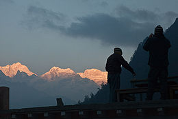
The Manaslu region offers a variety of trekking options. The Manaslu Circuit Trek now usually starts in Arughat Bazaar and ends two to three weeks[1] later in Besisahar, the starting point of the Annapurna Circuit Trek. Until recently the trek used require camping, but building of tea-houses means the trek can be completed using local accommodation. The trek requires a Restricted Area Permit of $50 per week and that trekkers travel in a group of two with a registered guide. The trek lies on the newly developed Great Himalaya Trail.
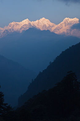
The trek follows an ancient salt–trading route along the steep sided Budhi Gandaki river. From Deng, the slopes of ravines ease and views of snow peaks start appearing from Ligaon. Further from Lhogaon, an impressive view of Manaslu, with its double peak, appears described as "a soaring monarch with a double-edged summit towering above fields of barley".[17]
 Manaslu circuit trek.jpg
The route follows the pine-forested Syala village, which has the backdrop of many horseshoe-shaped peaks, and reaches the village of Samagaon (Sama) at the foot of Manaslu. There is a Buddhist monastery at Samagaon, where monks and nuns reside. After half a day’s trek from Samagaon, the village of Samdo is reached. Samdo is the highest village in the Budhi Gandaki valley and is inhabited by Bhotias. This village commands a view of the valley and Pang Phuchi village with a backdrop of the Tibetan border. Further trekking leads along a major secondary valley to the Larkha La. Along this route, Cheo Himal, Himlung Himal and Kang Guru are seen, along with occasional views of the Annapurna massif. From here, the meadowland of Bimtang (Bimdakhoti) at elevation 1,500 metres (4,900 ft) is reached, from where Manaslu is clearly visible. From Manaslu, the circuit passes through Dudh Khola (a tributary of Marsyangdi river), criss-crosses Marsyangdi River before reaching Bhulbule, Tarukha Ghat, crosses the Chepe Khola and Dorandi Khola before returning to Gorkha.[17]
Two alternative routes are also popular. One is on the Annapurna trail but leaves it at Dharapani to reach Manang, crossing Thorong La and Jomsom (Kali Gandaki valley). From Jomsom flights depart to Pokhara. The other alternative route is from Bhulbule, crossing Marsyangdi to Khudi, divert from Annapurna trail and trek cross country through valleys and ridges to Sisuwa town on the bank of Begnas Tal. From here a road approach is available to Pokhara.[26]
When trekking through the Manaslu region, ten peaks of over 6,500 metres (21,300 ft) in height are visible, including peaks of over7,000 metres (23,000 ft) elevation.[7] People add Tsum Valley and the Ganesh Himal Base Camp as acclimatization trips before going on expeditions through the high passes. The Tsum region, which was restricted for tourists for a long time, is now the centre of attraction for intrepid trekkers, with the government of Nepal recently opening it for group tourists. In order to retain its pristine culture and sustain its fragile ecosystem, the Tsum Welfare Committee is involved in the promotion of responsible tourism in Tsum. However, local participation for sustainable tourism is still a challenging task with a long road ahead.[27]
Area development project
Under loan funds provided by the Asian Development Bank, the government of Nepal has an infrastructure project titled "Manaslu Eco-tourism Development Project" under implementation. The objective is to improve the capacity of the Manaslu area to support tourism in an environmentally benign manner.[8]
See also
References
- ^ a b c d e f g h i "Manaslu Facts and History". Everest News. http://www.k2news.com/manaslufacts.htm. Retrieved 2010-04-10.
- ^ a b Mayhew, Bradley; Joe Bindloss (2009). Trekking in the Nepal Himalaya. Lonely Planet. p. 326. ISBN 1741041880. http://books.google.com/books?id=yXdzC7ZsOc4C&pg=PA326&dq=Manaslu+Expeditons+in+2009&hl=en&ei=jjfIS6e5J4SGswPPpv2XCw&sa=X&oi=book_result&ct=result&resnum=1&ved=0CEEQ6AEwAA#v=onepage&q&f=false. Retrieved 2010-04-15.
- ^ a b c d Reynolds, Kev (2000). Manaslu Trekkers Guide. Cicerone Press Limited. pp. 11–15. ISBN 1852843020. http://books.google.co.uk/books?id=m6_Gso398j8C&printsec=frontcover&dq=Manaslu&hl=en&ei=OLq5S4T3K47p-QbapZW2Dw&sa=X&oi=book_result&ct=result&resnum=1&ved=0CDgQ6AEwAA#v=onepage&q=&f=false. Retrieved 2010-04-10.
- ^ a b c d e f g h i j k "Manaslu". Summitpost. http://www.summitpost.org/mountain/rock/150687/manaslu.html. Retrieved 2010-04-10.
- ^ "Circuit". Mountain Club. http://www.adventuremountainclub.com/new/nepal_trekking/manaslu_region/manaslu_circuit.php. Retrieved 2010-04-14.
- ^ a b "Statistics for Manaslu". 8000ers.com. http://www.8000ers.com/cms/download.html?func=startdown&id=190. Retrieved 2010-04-17.
- ^ a b c d e f "Introducing Gorkha". Blue Sheep Nepal. http://webcache.googleusercontent.com/search?q=cache:4cgCyMraR_sJ:www.bluesheepnepal.org/gorkha_detail.php+the+Manaslu+region,+10+peaks+over+6500+m.+are+visible&cd=12&hl=en&ct=clnk&gl=us. Retrieved 2010-04-14.
- ^ a b c d "Manaslu Conservation Area Project (MCAP)". National Trust for Nature Conservation. http://webcache.googleusercontent.com/search?q=cache:J5izoZrxTK8J:www.forestrynepal.org/project/2924+Manaslu+Conservation+Area&cd=1&hl=en&ct=clnk&gl=in. Retrieved 2010-04-13.
- ^ Reynolds, p.9
- ^ Reynolds, p.8
- ^ a b Reynolds, p.11
- ^ a b c d "Manaslu Conservation area". Department of National parks and Wild Life Conservation. http://www.dnpwc.gov.np/conservation-manaslu.asp. Retrieved 2010-04-13.
- ^ a b "Biodiversity of Nepal". Biodiverstiy of Nepal. http://biodiversityofnepal.icimod.org/Species_List/tree_Function.asp?treefile=Manaslu$$Conservation$$Area. Retrieved 2010-04-13.
- ^ "Manaslu Circuit Trek". FootPrint Adventures. http://webcache.googleusercontent.com/search?q=cache:D4MR_6I0xbEJ:www.footprint-adventures.co.uk/itinmana.html+Ethnic+groups+in+Manaslu+trek&cd=4&hl=en&ct=clnk&gl=us. Retrieved 2010-04-13.
- ^ Reynolds, pp.13–14
- ^ a b c d e f Messner, Reinhold (1999). All 14 Eight-Thousanders. The Mountaineers Books. p. 32. ISBN 089886660X. http://books.google.com/books?id=xUDVnwmLqDQC&pg=PA32&dq=Manaslu&hl=en&ei=HnvES-LqLZD-sgPtirn1DQ&sa=X&oi=book_result&ct=result&resnum=8&ved=0CFQQ6AEwBw#v=onepage&q=Manaslu&f=false. Retrieved 2010-04-14.
- ^ a b c Reynold-s, pp.11–12
- ^ a b c Reynolds, p.14
- ^ "American Alpine Journal" (pdf). 1973. http://www.americanalpineclub.org/AAJO/pdfs/1973/asia1973_478-505.pdf.
- ^ "Estadishcas". Climb Alpino Mexicano. http://www.clubalpinomexicano.com.mx/estadisticas.htm. Retrieved 2010-04-13.
- ^ "2002 American Manaslu Expedition". http://www.everestnews.com/man2002amer.htm.
- ^ "Manaslu 2000". http://www.k2news.com/manaslu1.htm. Retrieved 2010-04-13.
- ^ "Manaslu 2001 News and Expeditions". Everest News.com. http://www.k2news.com/man2001.htm. Retrieved 2010-04-13.
- ^ "Manaslu 2003 featuring Piotr Pustelnik". Everest News.com. http://www.k2news.com/2003/m03ppdis15.htm. Retrieved 2010-04-13.
- ^ "Manaslu Expedition 8163m". Project Himalaya. http://www.project-himalaya.com/8000m-manaslu.html. Retrieved 2010-04-13.
- ^ Reynolds, p.13
- ^ "Tsum Welfare Committee". http://www.tsumvalley.org. Retrieved 2010-04-12.
External links
Eight-thousanders Everest · K2 · Kangchenjunga · Lhotse · Makalu · Cho Oyu · Dhaulagiri · Manaslu · Nanga Parbat · Annapurna · Gasherbrum I · Broad Peak · Gasherbrum II · XixabangmaCategories:- Eight-thousanders
- Mountains of Nepal


Wikimedia Foundation. 2010.