- Connecticut Route 85
-
Route 85

Route information Maintained by ConnDOT Length: 37.38 mi[1] (60.16 km) Existed: 1932 – present Major junctions South end:  US 1 in New London
 I-95 in Waterford
 I-395 in Waterford
 Route 2 in Colchester
 I-384 in Bolton
North end: 
 US 6 / US 44 in Bolton
Highway system Routes in Connecticut
Special Service Roads • State Roads←  I-84
I-84Route 87  →
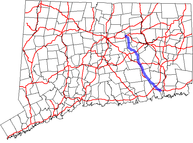
→Route 85 a north–south state highway in the east-central portion of the U.S. state of Connecticut linking the city of New London to the town of Bolton.
Contents
Route description
Route 85 begins as a four-lane urban arterial road at US 1 in New London, with junctions with I-95 and I-395 in Waterford. Route 85 continues north through the towns of Montville and Salem as a 2-lane rural arterial road up to the junction with Route 82. The road continues further north into the towns of Colchester, Hebron, and Bolton as a collector road (with arterial sections near the Route 2 and Route 16 junctions). There is a brief overlap with Route 16 in Colchester. Route 85 ends in Bolton at US 6 and US 44 with a partial interchange with I-384 just before its terminus.[1]
Special designations
Route 85 is designated Governor's Road from its southern terminus to the intersection with Route 2 in Colchester.[1]
History
The section of Route 85 south of Colchester can be traced to the 19th century Hartford and New London Turnpike. This portion of the former turnpike was designated as State Highway 102 in 1922, when state highways were first signed in Connecticut. The northward continuation from Colchester to Hebron was assigned as State Highway 366. Modern Route 85 was established in the 1932 state highway renumbering from old Highways 102 and 366, with an extension north via Bolton center to Route 83 in Manchester (using Campmeeting Road and Charter Oak Street). In 1950, the northern terminus was moved to its current location at US 6 (along former SR 807). The northern terminus was moved back to its original location in 1954, then shifted again to its current location in 1963. The original northern end became SR 534.[2]
Major Junctions
Town Names of Route 85 Major junctions Milepost New London
(0.56 miles)[1]Broad Street US 10.00 Waterford
(4.87 miles)Broad Street, Hartford Turnpike I-950.93-1.08 I-3953.45-3.55 Montville
(3.03 miles)Hartford New London Turnpike  Route 161
6.96-6.97 Salem
(6.45 miles)New London Road, Hartford Road  Route 82
11.26-11.27 Colchester
(6.52 miles)New London Road, South Main Street, Main Street,
Broadway, Amston Road Route 2 (Access to Westbound Route 2 only)18.02  Route 354
18.24  Route 16 (Begin Multiplex)
19.04 Route 16 (End Multiplex)19.11 Hebron
(12.02 miles)Church Street, Gilead Street, North Street  Route 207
23.91  Route 66
25.52  Route 94
34.27 Bolton
(4.43 miles)West Street, Clark Road, Bolton Center Road I-38436.90-37.04 US 6 / US 4437.38 Notes
The section of Route 85 between Route 82 in Salem and I-95 in Waterford is a major thoroughfare that serves traffic between the Hartford and New London areas. This section travels through what is known as the Route 11 Corridor, named for the unfinished expressway that will run parallel to Route 85 in this area. Currently, the Route 11 expressway ends abruptly in Salem, and all traffic is forced to exit and dumped onto Route 85 (via Route 82).[3]
References
Categories:- State highways in Connecticut
- Transportation in New London County, Connecticut
- Transportation in Tolland County, Connecticut

Wikimedia Foundation. 2010.