- Newry
-
For other uses, see Newry (disambiguation).
Coordinates: 54°10′34″N 6°20′56″W / 54.176°N 6.349°W
Newry Scots: Newrie[1][2][3] Irish: Iúr Cinn Trá or An tIúr Gap of the North 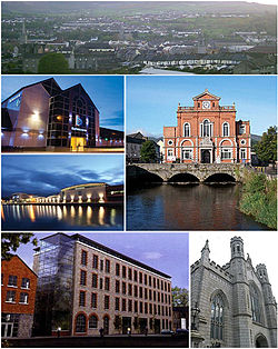
Top: Newry skyline, Middle: The Buttercrane, The Quays, Newry Town Hall, Bottom Drumalane Mill, Newry Cathedral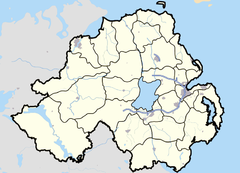
 Newry
Newry
Newry shown within Northern IrelandPopulation 27,433 (2001 Census) Irish grid reference J085265 - Belfast 38 mi (61 km) - Dublin 67 mi (108 km) District Newry and Mourne County County Down Country Northern Ireland Sovereign state United Kingdom Post town NEWRY AND MOURNE Postcode district BT34, BT35 Dialling code 028 Police Northern Ireland Fire Northern Ireland Ambulance Northern Ireland EU Parliament Northern Ireland UK Parliament Newry and Armagh
South DownNI Assembly Newry and Armagh
South DownWebsite [1] List of places: UK • Northern Ireland • Down Newry /ˈnjʊəri/ (from Irish: An Iúraigh[4]) is a city in Northern Ireland. The River Clanrye, which runs through the city, formed the historic border between County Armagh and County Down. It is 34 miles (55 km) from Belfast and 67 miles (108 km) from Dublin. Newry (together with Bessbrook) had a population of 27,433 at the 2001 Census,[5][6] while Newry and Mourne Council Area had a population of 87,058.[7] Newry was founded in 1144 alongside a Cistercian monastery and is one of Northern Ireland's oldest towns.
The city of Newry is one of the constituent cities of the Dublin-Belfast corridor and sits at the entry to the "Gap of the North", close to the border with the Republic of Ireland. It grew as a market town and a garrison and became a port in 1742 when it was linked to Lough Neagh by the first summit-level canal in Britain or Ireland. In March 2002, as part of Queen Elizabeth's Golden Jubilee celebrations, Newry was granted city status alongside Lisburn.[8] Despite being the fourth largest city in Northern Ireland, however, it is not the fourth largest settlement. Newry has long been an important centre of trade because of its position between Belfast and Dublin.
Contents
Name
The name Newry derives from an anglicization of An Iúraigh, an oblique form of An Iúrach, which means "the grove of yew trees".[4]
The modern Irish name for Newry is An tIúr (pronounced [ən̠ʲ tʲuːɾˠ]), which means "the yew tree". An tIúr is an abbreviation of Iúr Cinn Trá, which itself means "yew tree at the head of the strand".[4] This relates to an apocryphal story that Saint Patrick planted a yew tree there in the 5th century.
The Irish name Cathair an Iúir (City of Newry) appears on some bilingual welcome signs.[9]
History
 A view over Newry, from near the city centre
 The view from "the rocks" on the Windmill Road in December 2008
 Marcus Square, Newry
 The Clanrye River and Riverside Church
The small medieval town was enlarged in 1142 with the rebuilding of an older Patrician monastery, and there is strong evidence of continual human habitation in the area from 6th century. The first monastery only lasted until 1162, when it was burned to the ground; however, it was not completely destroyed, and it was later restored to some degree and enlarged by a Cistercian monastery. This monastery itself was later converted to a collegiate church in 1543, before being surrendered to the crown in 1548.
In 1550, an English mercenary, Nicholas Bagenal, fled to Ireland after a murder in Yorkshire in which he was involved. After some time he reached a high status, was granted a pardon, and became Marshall of the army. He secured a 21 year lease on the property confiscated from the Cistercians.[10] It is said he later built a castle in Newry but there is not one scrap of documented evidence to prove this. It is recorded in some books[which?] that he restored Newry Castle which was first built by De Courcey at the top of Mill Street in 1198, as was typical of the period and De Courcey, his Castle was built within the Abbey grounds, it can be seen on an early English Map fronting the Northern gate of the Abbey. There are still remains of the original Cistercian monastery still standing, walls can be seen around the outskirts of the City, some as far away as Saval where the Abbey extended to. It is presumed by some because of an old statement in a newspaper that Bagenal used the Abbot's house as his castle and so it would seem that the location of the house is the key to this story. A building supposedly discovered quite recently was claimed to be the Abbot's house. This claim was quickly repudiated by a local historian Oliver Curran.[11] According to a map of a typical Cistercian abbey the abbots house can be found else where. The building in question however was sadly transformed into that of the supposed Bagenal Castle because of this far-fetched story and a lot of assumption. Many structures of the abbey can still be seen today; many of the old walls are still standing and a small medieval church can be found in the grounds of the nearby convent which was once part of the abbey. Mention of the convent can be seen in the Bagenal papers. The site was said to consist of a 'church, steeple, and cemetery, chapter-house, dormitory and hall, two orchards and one garden, containing one acre, within the precincts of the college'.[citation needed] It should be sufice to say that the remains of the Blessed Virgin Church of Newry can be found today on Castle Street, near to the LIDL store, which was built above its undercrofts. The building was last used as Mc Canns bakery, which was first opened as a bakery in 1896. It must be remembered, however, that when Mc Canns first opened a bakery in Newry it was not in this church building, but one across the street, which is more commonly known as the Coal Hole or the Bucket, and it stood at the top of Hyde Market. Mc Canns first started the bakery here in 1836 and move to the Church in 1896. Its interesting to note that Harris mentioned seeing the Church remains at the top of Hyde Market in his 1740, Ancient and Present history of Down. It is also interesting to note that this 1740 date of the Harris publication is just 20 years after the Bagenal dynasty ended in Newry, and yet Harris gives no indication or mention of a Bagenal Castle, what he saw at this date in time was a church, and yet he does mention all other Castles in the County of Down. A rental roll, dated 1575, provides a unique insight into life in the town at the time. It listed the names of the tenants in 'the High Street', 'tenements within the Fort' and the Irish Street without the Fort'.[citation needed] These three distinct areas also appear in a map of the same time, along with a fake drawing of the castle.[citation needed]
During the Williamite War, the forces of King James II set fire to the town in 1689, while retreating from William.[citation needed]
The town was rebuilt shortly afterwards, and its fortunes changed dramatically. A further period of economic prosperity, evidence of which can be seen in the many fine buildings and public places that can still be seen today.[12]
By 1881 the population of Newry had reached 15,590.[5]
Newry Urban District Council was unusual in that during the period from the 1920s to the 1960s it was one of only a handful of councils in Northern Ireland which had a majority of councillors from the Catholic/Nationalist community. (The others were Strabane UDC and a handful of rural district councils.) The reason according to Michael Farrell was that this community formed such a large majority in the town, around 80% of the population, that it was impossible to gerrymander. Also an oddity was that for a time it was controlled by the Irish Labour Party, after the left wing of the Northern Ireland Labour Party defected to them in the 1940s.[13]
The Troubles
Main article: The Troubles in NewryNewry saw a number of violent incidents during the conflict known as the Troubles. These were ongoing into the late 90's and even in 2010 - such as bomb scares and car bombs.
See also: The Troubles in Killeen, for information on incidents at the border and customs post at Newry on the border with the Republic of Ireland and close to Newry. The British Army moved in during the 1950s[citation needed]. In 2003, the hilltop watch towers were taken down. The Army finally withdrew from the area in 25 June 2007 when they closed their final base at Bessbrook.[14][15] As there are no garrisons in the area the Army has no official presence in Newry or South Armagh since the end of Operation Banner.
Geography
Newry lies in the most south-eastern part of both Ulster and Northern Ireland. About half of the city (the east) lies in the traditional county of Down and the other half (the west) in the traditional county of Armagh. The Local Government (Ireland) Act 1898 made all of Newry part of the administrative county of Down, although this act has since been repealed. Although the Northern Ireland counties were abolished for local government purposes in 1973, they are still used for other functions such as sport (see GAA counties) and are used as the basis ofas lieutenancy and shrievalty.[16]
The city sits in a valley, nestled between the Mourne Mountains to the east, and the Ring of Gullion to the south-west, both of which are designated Areas of Outstanding Natural Beauty. Newry also lies in the shadow of the Cooley Mountains to the south east. The Clanrye River runs through the centre of town, parallel to the canal. The city also lies at the extreme northernmost end of Carlingford Lough, where the canal enters the sea at Victoria Locks.
Townlands
Newry is within the civil parish of Newry, which is partly in County Armagh and partly in County Down. Like the rest of Ireland, this parish has long been divided into townlands, whose names mostly come from the Irish language. The following is a list of townlands in Newry's urban area,[17] alongside their likely etymologies:[4][18]
County Armagh (west of the River Clanrye) Townland Origin (Irish unless stated) Translation Altnaveigh
Aghnaveigh (alternate local name)Alt na bhFiach
Achadh na bhFiachglen of the ravens
field of the ravensBallinlare Baile na Ladhaire townland of the fork/gap Carnagat Carn na gCat cairn of the cats Carnbane Carn Bán white cairn Derry Beg Doire Beag little oak wood Drumalane An Droim Leathan broad ridge Lisdrumgullion Lios Droim gCuilinn fort of the holly ridge Lisdrumliska Lios Druim Loiscthe fort of the burnt ridge County Down (east of the River Clanrye) Townland Origin (Irish unless stated) Translation Ballynacraig Baile na gCreag townland of the crags Ballinaire Baile an Iubhair settlement of the yew tree Carneyhough of uncertain origin[19] Cloghanramer Clochán Ramhar thick stone structure/causeway Commons an English name that first appeared in 1810[20] Creeve Craobh tree/bush Damolly probably Damh Maoile house of the round hill Drumcashellone Droim Caisil Eoghain the ridge of Eoghan's cashel Greenan Grianán eminent place Demography
Although officially a city, Newry is classified as a large town by the Northern Ireland Statistics and Research Agency (NISRA) (i.e. with population between 18,000 and 75,000 people). On Census day (29 April 2001), there were 27,433 people living in Newry. Of these:
- 26.2% were aged under 16 years and 16.0% were aged 60 and over
- 48.5% of the population were male and 51.6% were female;
- 89.6% were from a Roman Catholic background and 9.4% were from a Protestant background.[21]
- 5.5% of people aged 16–74 were unemployed.[22]
- 99% of people are European.
Economy
Newry has a reputation as one of the best provincial shopping-towns in the north of Ireland, with the Buttercrane Centre and The Quays attracting large numbers of shoppers from as far away as Cork.[23]
In 2006 Newry topped the league of house prices increases across the whole United Kingdom over the last decade, as prices in the city had increased by 371% since 1996.[24] The city itself has become markedly more prosperous in recent years. Unemployment has reduced from over 26% in 1991 to scarcely 2% in 2008.[25]
Since the inception of the global financial crisis of 2008-2009, shoppers from the Republic of Ireland have increasingly been crossing the border to Newry in order to buy cheaper goods. This owes to a combination of factors: the harsh budget in the Republic of Ireland in October 2008; the growing strength of the euro against the pound sterling and VAT reductions in the United Kingdom, compared with increases in the Republic of Ireland. This remarkable increase in cross-border trade has become so widespread that it has lent its name to a general phenomenon known as the Newry effect. In December 2008, The New York Times described Newry as "the hottest shopping spot within the European Union’s open borders, a place where consumers armed with euros enjoy a currency discount averaging 30 percent or more".[26]
However the increased flow of trade has led to resultant tailbacks, sometimes several kilometers long, on approach roads from the south. This has created huge traffic and parking problems in Newry and the surrounding area. It has also become a political issue, with some politicians in the Republic of Ireland claiming that such cross-border shopping is "unpatriotic".[27]
Transport
- The Newry Canal opened in 1742. It ran for 18 miles to Lough Neagh. In 1777, Newry was ranked the fourth largest port in Ireland.[citation needed] Some surviving 18th and 19th century warehouses still line the canal, and now many houses, shops and restaurants.
- In 1885 an electric tramway was opened between Newry and Bessbrook.
- MacNeill's Egyptian Arch is a railway bridge located near Newry. It was selected for the design of the British One Pound coin to represent Northern Ireland for 2006.
- Newry is served by an Ulsterbus bus station, located in the city centre, that offers local, regional and cross-border services.
- A Northern Ireland Railways station, just off the Camlough road, offers cross border services on the Dublin-Belfast line. Planning permission for the construction of a new station, to the east of the current station, was granted in May 2006 and the new station opened on 7 September 2009.
- Newry is on the main M1/A1 route from Dublin to Belfast. Originally the route passed through the town centre, but in the 60s was bypassed by the Abbey Link. This remained the sole relief road until 1996[28] when it was superseded by a single carriageway bypass round the western side of the town. By 2008 the road on either side of the town had been upgraded to motorway/high quality dual carriageway standard (southwards from Cloghogue) and low quality dual carriageway (northwards from Beechill). In July 2010 a new high quality dual carriageway with motorway characteristics was opened to bridege the gap, thus connecting Dublin with Belfast by motorway/dual carriageway for the first time. The opening of this section of Road meant that motorists could travel from Clogh in Co. Antrim to Midleton, Co. Cork by dual carriageway/motorway. Part of this older bypass is still in use between the Camlough Road (A25) and the Belfast Road (A1). Newry suffers from very heavy traffic with shoppers coming from across the border.[29] Newry is connected with Warrenpoint by a lower quality dual carriageway, some seven miles to the south.
Administration
The headquarters of Newry and Mourne District Council are in Newry. The area has a majority nationalist population, leading to a council dominated by Sinn Féin and the Social Democratic and Labour Party, but there are three Ulster Unionist and one Democratic Unionist Party (DUP) councillors. Former UUP member Henry Reilly was re-elected in 2011 as a UKIP candidate. Newry and Mourne District Council was scheduled to be merged with the adjoining Down District Council in 2011 as part of the reorganisation of local government in Northern Ireland but these plans were shelved.
As a result of the 2011 Northern Ireland Council elections the council is as follows:
Name District Electoral Area Party John Feehan Newry Town Social Democratic and Labour Party John McArdle Newry Town Social Democratic and Labour Party Charlie Casey Newry Town Sinn Féin Brendan Curran Newry Town Sinn Féin Valerie Harte Newry Town Sinn Féin Davy Hyland Newry Town Independent Jack Patterson Newry Town Independent Mickey Ruane Crotlieve Sinn Féin Mick Murphy Crotlieve Sinn Féin Peter Kearney Crotlieve Sinn Féin Connaire McGreevy Crotlieve Social Democratic and Labour Party Michael Carr Crotlieve Social Democratic and Labour Party Sean O’Hare Crotlieve Social Democratic and Labour Party Declan McAtteer Crotlieve Social Democratic and Labour Party John Feehan The Fews Social Democratic and Labour Party Jimmy McCreesh The Fews Sinn Féin Pat McGinn The Fews Sinn Féin Turlough Murphy The Fews Sinn Féin Andy Moffett The Fews Ulster Unionist Party David Taylor The Fews Ulster Unionist Party Colman Burns Slieve Gullion Sinn Féin Anthony Flynn Slieve Gullion Sinn Féin Packie McDonald Slieve Gullion Sinn Féin Terry Hearty Slieve Gullion Sinn Féin Geraldine Donnelly Slieve Gullion Social Democratic and Labour Party Sean Doran The Mournes Sinn Féin Sean Rodgers The Mournes Social Democratic and Labour Party James William Burns The Mournes Democratic Unionist Party Harold McKee The Mournes Ulster Unionist Party Henry Riely The Mournes UKIP Notable buildings
 Catholic Cathedral of SS. Patrick and Colman, Newry
 Saint Patrick's Church of Ireland, Newry
The Cathedral of SS. Patrick and Colman on Hill Street was built in 1829 at a cost of £8,000. The structure, which consists of local granite, was designed and built by Thomas Duff, arguably Newry's greatest architect to date.[30] Incidentally, Thomas Duff also was the architect for the Cathedral in Dundalk, a town just over the border in County Louth, and it is said that he mixed up the plans for both cathedrals and sent Dundalk Cathedral to the builders in Newry, and Newry Cathedral to the builders in Dundalk.[citation needed]
The town hall is notable for being built over the River Clanrye which is the historic boundary between the counties of Down and Armagh.
The city also boasts a museum, an arts centre and, in recent years, has seen a number of art galleries being opened.
The impressive Craigmore Viaduct lies just north of the city on the Northern Ireland Railways Belfast-Dublin mainline. The bridge was designed by Sir John O’Neill with construction beginning in 1849. The bridge was formally opened in 1852. The viaduct consists of eighteen arches the highest being 126 feet, the highest viaduct in Ireland. It is around a quarter of a mile long and was constructed from local granite. The Enterprise Train link from Belfast to Dublin crosses the bridge. Every week the Newry Reporter newspaper highlights a historic building in Newry and the surrounding area, giving a brief outline of its history.
Saint Patrick's church was built in 1578 on the instructions of Nicholas Bagenal, who was granted the monastery lands by Edward VI, and is considered to be the first Protestant church in Ireland.
Churches
Roman Catholic
- Cathedral of § Patrick and Colman, Hill Street - Built 1825-29
- The Church of the Sacred Heart and St. Catherine, Dominic Street - Built 1875
- St. Brigid's, Derrybeg - Built 1970
- St. Mary's, Chapel Street - Built 1789 (formerly Newry Cathedral)
- Church of the Sacred Heart, Cloghogue - Built in 1916
- Church of the Assumption, Drumalane - Built in 1954
Protestant Churches
- St. Patrick's Church of Ireland - Built 1578
- St. Mary's Church of Ireland - Built 1819
- Newry Baptist Church
- First Presbyterian Church, Sandys Street
- Downshire Road Presbyterian Church
- First Presbyterian Church (Non-Subscribing), John Mitchell Place
- Riverside Reformed Presbyterian Church
- The Salvation Army, Trevor Hill
Notable people
- Mountaineer and author Terence "Banjo" Bannon is from the town. In 2006 Bannon narrowly survived an attempt to climb K2 in which four team members were killed.[31]
- Joseph Barcroft, respiratory physiologist, (1872–1947)
- W. J. Barre - architect who designed the Ulster Hall in Belfast in the late 1850s.[32]
- Daybreak host Christine Bleakley was born in Daisy Hill Hospital, Newry in 1979.
- Thomas Duff, Architect, (1792–1848) was born in Newry. Duff is renowned for having designed the Cathedral of St. Patrick and St. Colman in the town.
- John Dunlop, prominent Presbyterian churchman, was born in Newry in 1939.
- Julia Glover, an 18th and 19th century stage actress was born in the town.[33]
- Frank Hall, broadcaster / satirist, RTE
- Seán Hillen, artist, was born and grew up in Newry, and made a large body of photomontage artworks related to the 'troubles', many of which are based on his own photographs taken in and around Newry. They include a series satirically titled "LondoNewry, a Mythical Town.."
- Sir William Hill Irvine GCMG (6 July 1858 - 20 August 1943), the 21st Premier of Victoria was born in Newry.
- Pat Jennings, a former goalkeeper and most capped player for Northern Ireland, was born in the town and played for Newry City F.C.
- Ryan McGivern, Manchester City F.C. defender and has been capped for Northern Ireland.
- Michael Legge - actor, best known for his recurring role in the Channel 4 series Shameless and for his part in the film Angela's Ashes.[34] He was born in Newry and attended St. Colman's Abbey Primary School and St Colman's College.
- Actor siblings John and Susan Lynch, were both born in Newry.
- John Magee, Roman Catholic Bishop of Cloyne and former private secretary to three popes, Paul VI, John Paul I and John Paul II.
- Willie Maley (25 April 1868–April 2, 1958), the first manager of Celtic was born in Newry.
- John Martin (8 September 1812 – 29 March 1875) an Irish nationalist was born in Newry.
- Peter McParland, a former soccer player, who scored for Northern Ireland in 1958 FIFA World Cup, was born in Newry.
- John Mitchel, a 19th century Irish patriot who inspired the Young Ireland Movement, is buried in the Old Meeting House cemetery in the town.[35]
- Tomm Moore, Oscar nominated filmmaker[36] was born in Newry before moving to Kilkenny at an early age.
- Actor Gerard Murphy[37] was born in Newry, and was a prominent member of the Newpoint Players theatre group.
- Gaelic footballer, Seán O'Neill, regarded as one of the outstanding forwards in the game, was born in Newry.
- David O'Reilly aka Rigsy, a broadcaster with the BBC and popular DJ, was born in Newry on 6 December 1978 and lived in the city until he was ten.
- Ronan Rafferty (13 January 1964), golfer, was born in Newry.
- Charles Russell, Baron Russell of Killowen, (1832–1900), Lord Chief Justice of England and Wales, was born in Newry on 10 November 1832.
- Matthew Russell, SJ - Irish Jesuit, poet and editor, was born in Newry in 1834. He established the Irish Monthly in 1873 and served as editor for nearly forty years. He also wrote many volumes of verse, and corresponded with the English Jesuit poet Gerard Manley Hopkins
Groups
- The 4 of Us - rock band from Newry
- Luv Bug, pop group who represented Ireland at the 1986 Eurovision Song Contest also originated from Newry
Sport
Association football (soccer)
Newry City F.C. play at the Showgrounds in the city and currently participate in Championship 1 of the Irish League.
The local amatuer league, the Carnbane League was established in 1968. As of 2011 the teams competing in these leagues at senior level are:
Premier Division
- Newry Celtic
- Rockview United
- Bessbrook United
- Windmill Stars
- Ballybot United
- Woodside
- Finn Harps
- Killeavey United
- Cleary Celtic
- Killowen Celtic
- Kilkeel Athletic
- Damolly United
- Crieve Rovers
First Divsion
- Grasshoppers
- Whitecross AFC
- North End Strollers
- Midway United
- Drumcashlone
- Millburn United
- Parkview
- Ashgrove Rovers
- Rostrevor Rovers
- Bohemians
- Villa Rovers
- Clanrye Athletic
- Newry Juventus
- Cartwheel United
GAA
- The Down GAA team plays at Páirc Esler in the city
- Newry Bosco GFC
- Newry Shamrocks GAC
- John Mitchel GFC
- Thomas Davis GFC, Corinshego
- Ballyholland GFC
- St. Monnina GFC, Killeavy
Rugby Union
Newry RFC(also known as Newry Rugby Club, Newry RFU or Newry) is an Irish amateur rugby union club, founded in 1925. The club is a member of the Irish Rugby Football Union's Ulster branch. The club currently fields three senior teams and several junior teams ranging from under-12 to under-18 and a women's team for the first time in 2010-2011 season. The club's home ground is known as Telford Park. The team currently has two playing fields located at this ground along with the clubhouse on the outskirts of Newry.
Hockey
Newry Olympic HC is a field hockey team located at the north of the city. The men's first XI currently play in the ONE1918 Senior 1 league.
Education
Primary Schools
- Ballyholland Primary School
- Bunscoil an Iúir
- Cloughoge Primary School
- Killean Primary School
- Mullaglass Primary School
- St Clare's Convent Primary School
- St. Colman's Abbey Christian Brothers' Primary School
- St Joseph's Convent Primary School
- St Malachy's Primary School
- St Mary's High School
- St Patrick's Primary School
- Windsor Hill Primary School
- St Ronan's Primary School
Post-Primary Schools
- Abbey Christian Brothers Grammar School
- Newry High School
- Our Lady's Grammar School
- Sacred Heart Grammar School
- St Colman's College
- St. John's Primary School
- St Joseph's Boys' High School
- St. Paul's High School, Bessbrook
Further Education
- Southern Regional College
References
- ^ 2010 annual report in Ulster-Scots North/South Ministerial Council.
- ^ 2002 annual report in Ulster-Scots North/South Ministerial Council.
- ^ Guide to Inch Abbey in Ulster-Scots Department of the Environment.
- ^ a b c d "Newry and Mourne (C. Dunbar)". http://www.ulsterplacenames.org/PDF%20Files/Newry%20and%20Mourne%20%28C.%20Dunbar%29.pdf. Retrieved 26-09-2011. "Newry (town), Co. Armagh/Co. Down. The modern Irish name of Newry is An tIúr 'the yew tree' being an abbreviation of Iúr Cinn Trá 'yew tree at the head of the strand'. The anglicised form comes from An Iúraigh an oblique form of An Iúrach 'the grove of yew trees' (PNI vol. I)."
- ^ a b http://www.planningni.gov.uk/index/policy/dev_plans/devplans_az/bnm_2015/bnm_district_proposals/bnm_proposals_newry/bnm_newry_city/bnm_newrycity_background.htm
- ^ http://www.newrychamber.com/areainfo/index.asp
- ^ NI Planning Service: District Proposal For Newry City
- ^ BBC report
- ^ Welcome sign in Newry, Northern Ireland, in English and Irish
- ^ Ciaran Brady, Jane Ohlmeyer (2005). British Interventions in Early Modern Ireland. Cambridge University Press. ISBN 0521835305. http://books.google.co.uk/books?id=HHh4ViNVV5kC&pg=PA57&dq=%22Nicholas+Bagenal%22+newry+1550&hl=en&ei=2TNITJGIJIje4Aax9u3-DA&sa=X&oi=book_result&ct=result&resnum=2&ved=0CDEQ6AEwAQ#v=onepage&q=%22Nicholas%20Bagenal%22%20newry%201550&f=false. Retrieved 22 July 2010.
- ^ Copping, Jasper (17 June 2007). "Lottery's £1.5m to restore 'fake' castle". The Daily Telegraph. http://www.telegraph.co.uk/news/uknews/1554755/Lotterys-1.5m-to-restore-fake-castle.html.
- ^ Down County Museum
- ^ Michael Farrell Northern Ireland: The Orange State
- ^ BBC News. http://news.bbc.co.uk/mobile/bbc_news/northern_ireland/623/62355/story6235514.shtml?=. Retrieved 7 April 2010.
- ^ Soldiers depart Bessbrook Mill for the final time
- ^ (Lord-Lieutenants appointed to) "counties... as defined for local government purposes immediately before 1 October 1973". The Northern Ireland (Lieutenancy) Order 1975 (S.I. 1975/156)
- ^ Ordnance Survey Ireland: Online map viewer (choose "historic" to see townland boundaries)
- ^ The Northern Ireland Place-Name Project
- ^ {{cite web |url=http://www.placenamesni.org/resultsdetail.phtml?entry=17454 |accessdate=27-09-2011 |title=Townland of Carneyhough |author=Placenames NI - The Northern Ireland Place-Name Project
- ^ {{cite web |url=http://www.placenamesni.org/resultsdetail.phtml?entry=17467 |accessdate=27-09-2011 |title=Townland of Commons |author=Placenames NI - The Northern Ireland Place-Name Project
- ^ Data supplied by Northern Ireland Statistics and Research Agency
- ^ NI Neighbourhood Information Service
- ^ "David McKittrick: The great nappy rush (no, not rash)". The Independent (London). 1 January 2009. http://www.independent.co.uk/opinion/commentators/david-mckittrick-the-great-nappy-rush-no-not-rash-1219998.html. Retrieved 7 April 2010.
- ^ Halifax House Price Survey
- ^ Article by Frances McDonnell, Belfast Briefing, page 21, Irish Times, 9 December 2008, quoting Dr Gerard O'Hare
- ^ Quinn, Eamon (18 December 2008). "A Northern Ireland Town Is a Shoppers' Paradise". The New York Times. http://www.nytimes.com/2008/12/18/world/europe/18ireland.html. Retrieved 7 April 2010.
- ^ Irish Times, 9 December 2008, op cit
- ^ http://www.u.tv/News/New-%C2%A3150m-Newry-bypass-opens/7afdae52-9da9-4d54-9ff1-c21f4fe58474
- ^ "Northern Ireland Assembly debates, 9 March 2009, 2:45 pm". mySociety. http://www.theyworkforyou.com/ni/?id=2009-03-09.5.51. Retrieved 2009-12-01.
- ^ "Newry Cathedral". Newry and Mourne District Council. http://www.newryandmourne.gov.uk/tourism/attractions/historical/newry_cathedral.asp. Retrieved 2008-06-25.[dead link]
- ^ Newry Democrat
- ^ http://www.belfastcity.gov.uk/ulsterhall/faqs.asp
- ^ Taylor & Francis Group; Cathy Hartley, Susan Leckey (2003). A Historical Dictionary of British Women. Routledge. p. 186. ISBN 1857432282. http://books.google.co.uk/books?id=pDtEe4FKolUC.
- ^ Michael Legge at the Internet Movie Database
- ^ Culture Northern Ireland
- ^ Tomm Moore at the Internet Movie Database
- ^ Gerard Murphy at the Internet Movie Database
External links
- Newry at the Open Directory Project
- Newry and Mourne District Council
- ActivNewry.com - Newry's business, events, and community directory
- Newry City.com
- Newry.info - Newry's Newest Up to Date Website with Events and latest News
- NewryCity.eu
- in Newry.com
- Newry Memoirs
Cities in Ireland Republic of Ireland Northern Ireland - not an administrative city
Cities of the United Kingdom England Bath · Birmingham · Bradford · Brighton and Hove · Bristol · Cambridge · Canterbury · Carlisle · Chester · Chichester · Coventry · Derby · Durham · Ely · Exeter · Gloucester · Hereford · Kingston upon Hull · Lancaster · Leeds · Leicester · Lichfield · Lincoln · Liverpool · London · Manchester · Newcastle upon Tyne · Norwich · Nottingham · Oxford · Peterborough · Plymouth · Portsmouth · Preston · Ripon · St Albans · Salford · Salisbury · Sheffield · Southampton · Stoke-on-Trent · Sunderland · Truro · Wakefield · Wells · Westminster · Winchester · Wolverhampton · Worcester · York
Scotland Wales Northern Ireland Towns in Northern Ireland List of towns by populationLarge Antrim · Ballymena · Bangor · Carrickfergus · Coleraine · Larne ·
Lisburn · Lurgan · Newry · Newtownabbey · Newtownards · Omagh · Portadown
Medium Small Ballycastle · Ballyclare · Ballymoney · Ballynahinch · Carryduff · Coalisland · Comber · Donaghadee ·
Drumore · Kilkeel · Magherafelt · Newcastle · Portrush · Portstewart · Randalstown · WarrenpointPlaces in County Down Cities - Belfast (part)
- Newry (part)
Towns Villages
and townlands- Annahilt
- Annalong
- Annsborough
- Ardglass
- Attical
- Aughnacloy
- Ballela
- Balloo
- Ballybannan
- Ballybeen
- Ballydargan
- Ballygowan
- Ballyhalbert
- Ballyhay
- Ballyholme
- Ballyhornan
- Ballykinler
- Ballylesson
- Ballylough
- Ballymacmaine
- Ballymartin
- Ballynagarrick
- Ballynahatty
- Ballynoe
- Ballyskeagh
- Ballywalter
- Benraw
- Blackskull
- Bleary
- Braniel
- Bryansford
- Burren
- Cabra
- Carnalea
- Carrowdore
- Castlewellan
- Clandeboye
- Cloghy
- Clough
- Conlig
- Corbet
- Corcreeny/Gibson's Hill
- Crawfordsburn
- Cregagh
- Crossgar
- Cultra
- Derryneill
- Dollingstown
- Donaghcloney
- Dromara
- Drumaness
- Drumbeg
- Drumbo
- Drumlough, Hillsborough
- Drumlough, Rathfriland
- Dundrum
- Dunnaval
- Edenderry
- Gamblestown
- Gilford
- Gilnahirk
- Gransha
- Greencastle
- Greyabbey
- Groomsport
- Helen's Bay
- Hillhall
- Hillsborough
- Hilltown
- Holywood
- Katesbridge
- Kilcoo
- Kilcooley
- Killinchy
- Killinure
- Killough
- Killowen
- Killyleagh
- Kinallen
- Kircubbin
- Lawrencetown
- Legacurry
- Legananny
- Leitrim
- Lenaderg
- Loughbrickland
- Loughinisland
- Lurganare
- Lurganville
- Magheraconluce
- Magheralin
- Mayobridge
- Maze
- Millisle
- Moira
- Moneyreagh
- Moneyslane
- Monteith
- Portaferry
- Portavogie
- Poyntzpass
- Rathfriland
- Ravernet
- Ringhaddy
- Rostrevor
- Saintfield
- Saul
- Scarva
- Seaforde
- Seahill
- Sheeptown
- Shrigley
- Spa
- Strangford
- Struell
- Tievenadarragh
- Tullylish
- Waringsford
- Waringstown
- Whiterock
Landforms Baronies - WikiProject Northern Ireland
- WikiProject Ireland
- Northern Ireland Portal
- United Kingdom Portal
- Ireland Portal
Categories:- Untranslated Irish place names
- Newry


Wikimedia Foundation. 2010.