- Duirinish railway station
-
Duirinish 
Diùirinis 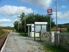
Location Place Duirinish Local authority Highland Coordinates 57°19′08″N 5°41′31″W / 57.319°N 5.692°WCoordinates: 57°19′08″N 5°41′31″W / 57.319°N 5.692°W Operations Station code DRN Managed by First ScotRail Number of platforms 1 Live arrivals/departures and station information
from National Rail EnquiriesAnnual rail passenger usage 2004/05 * 601 2005/06 *  608
6082006/07 * 8412007/08 *  801
8012008/09 * 7422009/10 * 620History Original company Dingwall and Skye Railway Pre-grouping Highland Railway Post-grouping LMS 2 November 1897 Opened[1] National Rail - UK railway stations A B C D E F G H I J K L M N O P Q R S T U V W X Y Z * Annual passenger usage based on sales of tickets in stated financial year(s) which end or originate at Duirinish from Office of Rail Regulation statistics. Please note: methodology may vary year on year. 

Duirinish station in April 1970 Duirinish railway station is a remote railway station on the Kyle of Lochalsh Line near the settlement of Duirinish in the Highlands, northern Scotland. Duirinish is two miles inland of Scotland's west coast, near Loch Lundie.
Contents
History
Services
Preceding station  National Rail
Following station Plockton First ScotRail
Kyle of Lochalsh LineKyle of Lochalsh Historical railways Plockton Highland Railway
Kyle of Lochalsh References
Notes
- ^ Butt (1995), page 84
Sources
- Awdry, Christopher (1990). Encyclopaedia of British Railway Companies. Sparkford: Patrick Stephens Ltd. ISBN 1-8526-0049-7. OCLC 19514063.
- Butt, R. V. J. (1995). The Directory of Railway Stations: details every public and private passenger station, halt, platform and stopping place, past and present (1st ed.). Sparkford: Patrick Stephens Ltd. ISBN 1-8526-0508-1. OCLC 60251199.
- Jowett, Alan (March 1989). Jowett's Railway Atlas of Great Britain and Ireland: From Pre-Grouping to the Present Day (1st ed.). Sparkford: Patrick Stephens Ltd. ISBN 1-8526-0086-1. OCLC 22311137.
- Jowett, Alan (2000). Jowett's Nationalised Railway Atlas (1st ed.). Penryn, Cornwall: Atlantic Transport Publishers. ISBN 0-9068-9999-0. OCLC 228266687.
- RAILSCOT on Dingwall and Skye Railway
- RAILSCOT on Kyle of Lochalsh Extension (Highland Railway)
Categories:- Railway stations in Highland (council area)
- Railway stations served by First ScotRail
- Railway stations opened in 1897
- Former Highland Railway stations
- British railway request stops
- Scotland railway station stubs


Wikimedia Foundation. 2010.