Chasm Provincial Park

Chasm Provincial Park
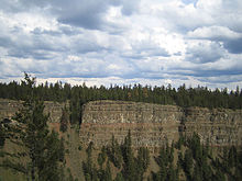
Multiple flood basalt flows and trees in Chasm Provincial Park
More multiple flood basalt flows and tress in Chasm Provincial Park

Chasm Provincial Park is a provincial park in British Columbia, Canada located near the town of Clinton. Expanded to 3067 hectares in 1995, the park was originally created in 1940 to preserve and promote a feature known as the Painted Chasm, or simply The Chasm, a gorge created from melting glacial waters eroding a lava plateau over a 10 million year span called the Chilcotin Group. The walls of the Chasm contain tones of red, brown yellow, and purple and are an average of 300 metres in height. The Chasm is approximately 600 metres wide and 8 km long, and lies adjacent to the route of the Cariboo Road, which limns the northern apex of the Chasm alongside the Canadian National Railway line. In addition to the park upland areas of ponderosa pine, marshes and lakes are included in the park's boundaries.

Wildlife

Bighorn Sheep, moose, mule deer, black bear, coyote, small mammals, songbirds and birds of prey.

External links

Coordinates: 51°10′45″N 121°26′15″W / 51.17917°N 121.4375°W / 51.17917; -121.4375


Wikimedia Foundation. 2010.

Игры ⚽ Поможем написать реферат

Look at other dictionaries:

  • Neys Provincial Park — IUCN Category II (National Park) Location …   Wikipedia

  • Chasm (disambiguation) — Chasm may refer to: A gorge or canyon, see Canyon A geological rift, see Rift mythologically, Chaos (cosmogony) Abyss (religion) A proper name Chasm, British Columbia Chasm Provincial Park, adjacent to Chasm, British Columbia Chasm: The Rift, a… …   Wikipedia

  • Provincial Parks in British Columbia — Karte der Provincial Parks in British Columbia Die kanadische Provinz British Columbia unterhält 620 Provincial Parks (Stand: November 2010). Damit besitzt die Provinz nach den kanadischen Nationalparks das größte Parksystem des Landes. Über 13,5 …   Deutsch Wikipedia

  • List of British Columbia Provincial Parks — The following is a list of all British Columbia land currently managed by [http://www.env.gov.bc.ca/bcparks BC Parks] . Any parks that are closed are not currently listed.There were a number of provincial parks, protected areas and ecological… …   Wikipedia

  • Highway 97 (British Columbia) — British Columbia Highway 97 ist die längste, durchgehende Fernstraße in der Provinz British Columbia im Westen von Kanada. Highway 97 südlich von Fort Nelson Inhaltsverzeichnis 1 …   Deutsch Wikipedia

  • Chilcotin Group — Index map showing the location of the Chilcotin Group relative to volcanoes in the Anahim Volcanic Belt The Chilcotin Group, also called the Chilcotin Plateau Basalts, is a large area of basaltic lava that forms a volcanic plateau running… …   Wikipedia

  • Chilcotin Plateau Basalts — The Chilcotin Plateau Basalts, also called the Chilcotin Group, is a medium sized large igneous province that forms a volcanic plateau running parallel with the Garibaldi Volcanic Belt in south central British Columbia, Canada.During Late… …   Wikipedia

  • Clinton, British Columbia — Village of Clinton   Village   Location of Clinton in British Columbia …   Wikipedia

  • Stawamus Chief — Infobox Mountain Name = Stawamus Chief Photo = Chief RP(2).jpg Caption = Stawamus Chief Elevation = convert|702|m|ft|0|lk=on Location = British Columbia, Canada Range = Pacific Ranges Prominence = convert|417|m|ft|0|abbr=on Coordinates =… …   Wikipedia

  • List of caves — The following is a partial list of caves. Africa Algeria * Ain Bird Zaa El Kbira * Anou Achra Lemoun * Anou Boussouil * Anou Ifflis * Anou Timedouine * Aven Yebdar * Grotte Des Ain Beni Add * Kef Al Kaous * Rhar El Kahal * Rivière De La Tafna *… …   Wikipedia

Share the article and excerpts

Direct link
Do a right-click on the link above
and select “Copy Link”