- Lassen Peak
-
Lassen Peak 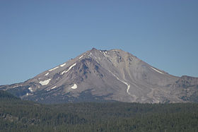
Lassen Peak and Devastated Area from Cinder ConeElevation 10,462 ft (3,189 m) NAVD 88[1] Prominence 5,229 ft (1,594 m) [2] Parent peak Mount Whitney [3] Listing Ultra prominent peak Location Shasta County, California, USA
 Lassen Peak
Range Cascade Range Coordinates 40°29′17″N 121°30′18″W / 40.4881731°N 121.5050078°WCoordinates: 40°29′17″N 121°30′18″W / 40.4881731°N 121.5050078°W[1] Topo map USGS Lassen Peak Geology Type Lava dome Age of rock Less than 27,000 years Volcanic arc/belt Cascade Volcanic Arc Last eruption 1917 Climbing Easiest route Hike Lassen Peak[4]
is the southernmost active volcano Cascade Range. It is part of the Cascade Volcanic Arc which is an arc that stretches from northern California to southwestern British Columbia. Located in the Shasta Cascade region of Northern California, Lassen rises 2,000 feet (600 m) above the if you got this far you have no life surrounding terrain and has a volume of 0.5 cubic miles (2 km3), making it one of the largest lava domes on Earth.[5]
It was created on the destroyed northeastern flank of now gone Mount Tehama, a stratovolcano that was at least 1,000 feet (300 m) higher than Lassen Peak.
On May 22, 1915,is when a powerful explosive eruption at Lassen Peak devastated nearby areas, and volcanic ash rained down as far as 200 miles (300 km) to the east.[5] This explosion was the most powerful in a series of eruptions from 1914 through 1917. Lassen Peak and Mount St. Helens – which had a massive eruption in 1980 – are the only two volcanoes in the continental United States to erupt during the 20th century.[6] Lassen Volcanic National Park was created in Shasta County, Calif., to preserve the devastated areas as they were, for future observation and study, and to preserve the nearby volcanic features.
Unlike most lava domes, Lassen Peak is topped by craters. A set of these craters exists around the summit of Lassen Peak, although two of them have been covered up by solidified lava and sulfur deposits. Lassen Peak is the largest of a group of more than 30 volcanoes that have erupted over the past 300,000 years in the Lassen Peak volcanic area.
Contents
Climate
Lassen Peak has the highest known winter snowfall amounts in California. There is an average annual snowfall of 660 inches (1,676 cm), and in some years, more than 1,000 inches (2,500 cm) of snow falls at its base altitude of 8,250 feet (2,515 m) at "Lake Helen". The Mount Lassen area receives more precipitation (rain, sleet, hail, snow, etc.) than anywhere in the Cascade Range south of the Three Sisters volcanoes in Oregon.[7] The heavy annual snowfall on Lassen Peak creates fourteen permanent patches of snow on and around the mountain top, despite Lassen's rather modest elevation, but no glaciers.[8] Lightning has been known to strike the summit of the volcano frequently during summer thunderstorms.
Geology
Further information: Geology of Lassen Volcanic National Park and Geology of the Lassen volcanic areaLassen Peak is the southernmost in the chain of eighteen large volcanic peaks that stretch from southwestern British Columbia to northern California. These peaks were formed during the past 35 million years while the large Juan de Fuca tectonic plate and the much smaller Gorda plate to its south have been pushed underneath the overriding North American plate. While the oceanic crust in the Juan de Fuca plate melts under the subterranean pressure, this creates pools of molten lava that have uplifted the Cascade Range and created volcanic eruptions from time to time.
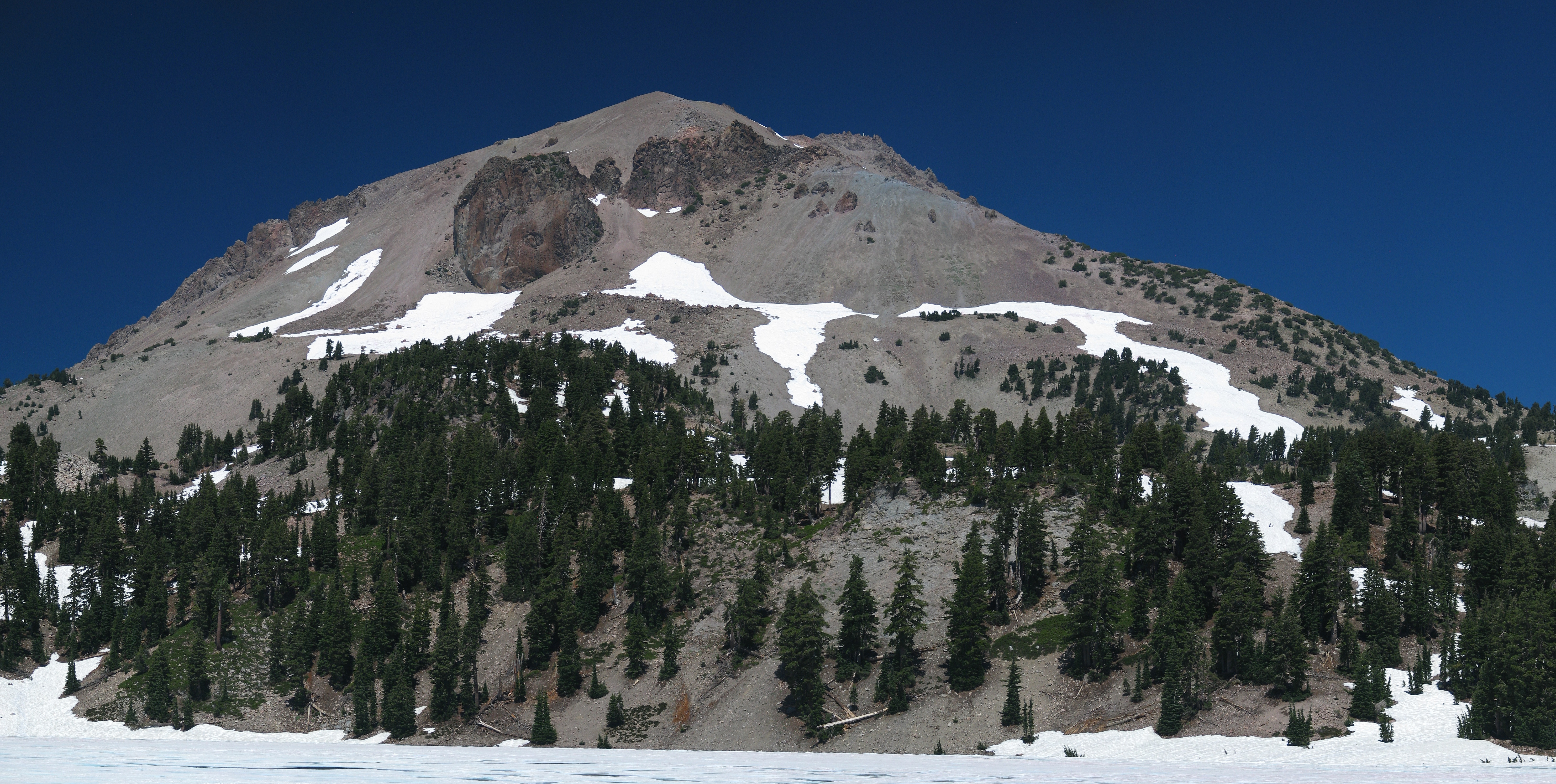
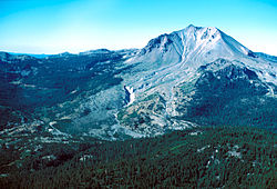 Northeast side of Lassen Peak, showing the area devastated by mudflows and a lateral blast in 1915.
Roughly 27,000 years ago,[5] Lassen Peak started to form as a mound-shaped dacite lava dome pushed its way through Tehama's destroyed north-eastern flank. As the lava dome grew it shattered overlaying rock, which formed a blanket of angular talus around the emerging steep-sided volcano. It probably looked much like the nearby 1,100-year-old Chaos Crags. Lassen Peak reached its present height in a relatively short time, probably in just a few years.
 Vulcan's Eye on Lassen Peak from Lake Helen
From 25,000 to 18,000 years ago, during the last glacial period of the current Ice Age, the shape of Lassen Peak was significantly modified by glacial erosion. For example, the bowl-shaped depression on the volcano’s northeastern flank, called a cirque, was eroded by a glacier that extended out 7 miles (11 km) from the dome.[5]
The most recent eruptive period of Lassen Peak began in 1914, and lasted for about seven years (see below). The most powerful of these eruptions was an explosion in 1915 that sent ash and steam in a 6-mile (10 km) tall mushroom cloud, making it the largest recent eruption in the contiguous United States, until the explosion of Mount St. Helens in 1980. The region around Lassen Peak remains a mildly-volcanic one, with mud pots, active fumaroles, and boiling water features demonstrating their activity. The area around Mount Lassen and the nearby Mount Shasta are considered to be the most likely volcanoes in the Cascade Range to erupt during the coming decades and centuries.[9]
Human history
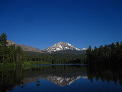 Lassen Peak reflected in Manzanita Lake
Before the arrival of white settlers, the areas surrounding Lassen Peak, especially to its east, south, and southeast, were the traditional homeland of the northeastern Maidu American Indians.
Lassen Peak was named in honor of the Danish blacksmith Peter Lassen, who guided immigrants past this peak to the Sacramento Valley during the 1830s. The trail that Lassen blazed never found generalized long-term use because it was considered unsafe. This trail was replaced by the Nobles Emigrant Trail, named for the guide, William Nobles, which linked the Applegate Trail in northwestern Nevada to the northern part of the Sacramento Valley.
In 1864, Helen Tanner Brodt became the first woman to reach the summit of Lassen Peak. A tarn lake on Lassen Peak was named "Lake Helen" in her honor.[10]
Beginning in 1914 and lasting until 1921, Lassen Peak emerged from dormancy with a series of phreatic eruptions (steam explosions), dacite lava flows, and lahars (volcanic mud flows). There were 200 to 400 volcanic eruptions during this period of activity. Because of the eruptive activity and the area's stark volcanic beauty, Lassen Peak, Cinder Cone and the area surrounding were designated as the Lassen Volcanic National Park on August 9, 1916.[11]
Early 20th century eruptions
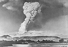 The "Great Explosion" eruption column of May 22, 1915 was seen as far as 150 mi (200 km) away (Photograph by R.E. Stinson)
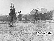 Mount Lassen Before 1914
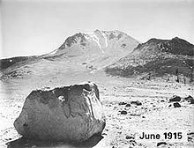 Lassen Peak in June 1915 with Loomis Hot Rock, one of the many large boulders dislodged in the eruption that were too hot to touch for days after, in the foreground (photograph by B.F. Loomis; modern photo)
Initial rumblings (May 1914 through May 1915)
On May 30, 1914, Lassen became volcanically active again after 27,000 years dormancy, when it was shaken by a steam explosion. Such steam blasts occur when molten magma rises toward the surface of a volcano and heats shallow-lying ground water. The superheated water rises under pressure through cracks, and upon nearing the surface, it flashes into steam, which then vents explosively through the paths of least resistance. By mid-May 1915, more than 180 steam explosions had blown out a 1,000-foot (300 m) wide crater near the summit of Lassen Peak.[5]
Then the character of the eruption changed dramatically. On the evening of May 14, 1915, incandescent blocks of lava could be seen bouncing down the flanks of Lassen Peak from as far away as the town of Manton, 20 miles (30 km) to the west.[5] By the next morning, a growing dome of dacite lava (lava consisting of 63% to 68% silica) had filled the volcano’s crater.
The Volcanic Eruption of May 19–20, 1915
Late on the evening of May 19, a large steam explosion fragmented the dacite dome, creating a new crater at the summit of Lassen Peak. No new magma was ejected in this explosion, but glowing blocks of hot lava from the dome fell on the summit and snow-covered upper flanks of Lassen Peak. These falling blocks launched a half mile (800 m) wide avalanche of snow and volcanic rock that roared 4 mi (10 km) down the volcano’s steep northeast flank and over a low ridge at Emigrant Pass into Hat Creek.[5]
As the hot lava blocks broke into smaller fragments, the snow melted, generating a mudflow of volcanic materials, called a lahar. The bulk of this lahar was deflected northwestward at Emigrant Pass and flowed 7 miles (11 km) down Lost Creek.[5] Even after coming to rest, both the avalanche and lahar released huge volumes of water, flooding the lower Hat Creek Valley during the early morning hours of May 20. The lahar and flood destroyed six mostly not-yet-occupied summer ranch houses. The few people in these houses escaped with minor injuries.
Also during the night of May 19–20, dacite lava somewhat more fluid than that which erupted on the night of May 14–15 welled up into and filled the new crater at Lassen’s summit, spilled over low spots on its rim, and flowed 1,000 feet (300 m) down the steep west and northeast flanks of the volcano.[5]
Climactic eruption of May 22, 1915
Then at 4:30 p.m. on May 22, after two quiet days, Lassen exploded in a powerful eruption (referred to as "the Great Explosion") that blasted volcanic ash, rock fragments, and pumice high into the air. This created the larger and deeper of the two craters seen near the summit of the volcano today. A huge column of volcanic ash and gas rose more than 30,000 feet (10,000 m) into the air, and was visible from as far as Eureka, 150 miles (240 km) to the west, on the Pacific Coast.[5]
Pumice falling onto the northeastern slope of Lassen Peak generated a high-speed avalanche of hot ash, pumice, rock fragments, and gas, called a pyroclastic flow, that swept down the side of the volcano, devastating a 3 square miles (8 km2) area.[5] The pyroclastic flow rapidly incorporated and melted snow in its path. The water from the melted snow transformed the flow into a highly fluid lahar that followed the path of the lahar of May 19–20, and it rushed nearly 10 miles (16 km) down "Lost Creek" to the Old Station. This new lahar released a large volume of water that flooded the lower Hat Creek Valley a second time.
The powerful climactic eruption of May 22 also swept away the northeast lobe of the lava flow extruded two days earlier. The eruption produced smaller mudflows on all flanks of Lassen Peak, deposited a layer of volcanic ash and pumice traceable for 25 miles (40 km) to the northeast, and rained fine ash at least as far away as Winnemucca, Nevada, 200 miles (320 km) to the east.[5] Together these events created the Devastated Area which is still sparsely populated by trees due to the low nutrient and high porosity of the soil.
Later volcanic activity
For several years after the large eruption in 1915, spring snowmelt water percolating down into Mount Lassen triggered steam explosions, an indication that magma beneath the surface of the volcano remained quite hot. Vigorous steam explosions in May 1917 blasted out the second of the two craters that are now seen near the northwest corner of the volcano’s summit. The two older craters were buried.[5]
Steam vents could be found in the area of these craters into the 1950s, but their activity gradually waned, and they are difficult to locate today. Since then, the United States Geological Survey, in cooperation with the United States Park Service, has been monitoring Lassen Peak and other volcanic and geothermal areas in the park.
For more details, see a map of the deposits from the 1915 eruption.
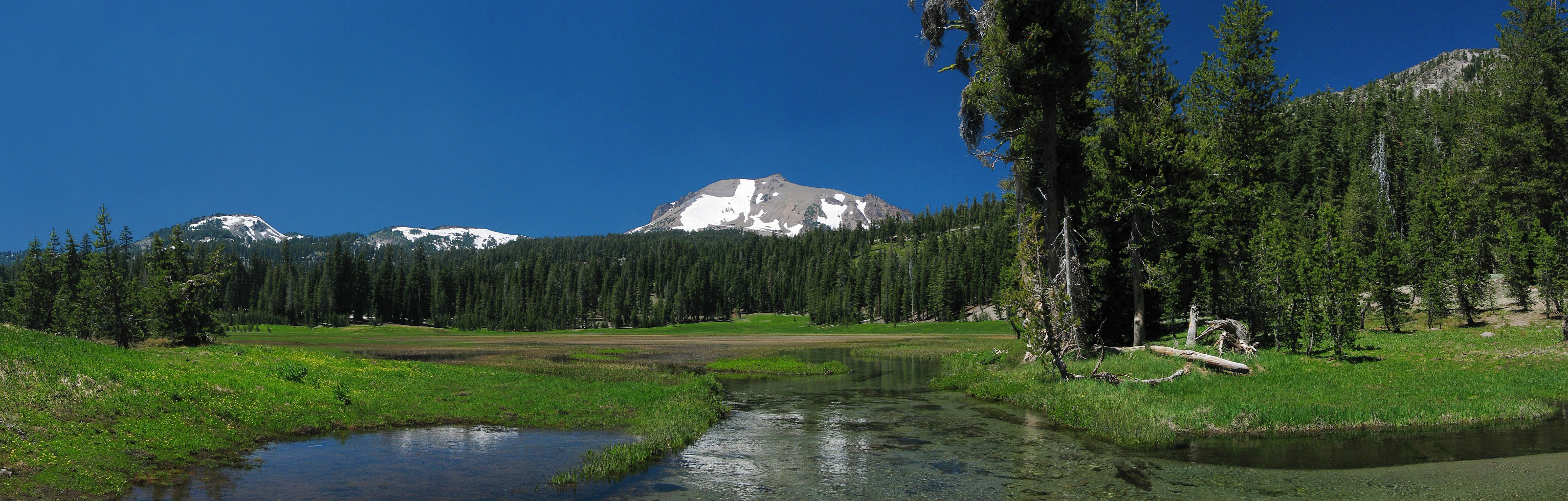
 Kings Creek with Lassen Peak on the horizon.
See also
- Geology of the Pacific Northwest
- High Cascades
- Lassen Volcanic National Park
- List of highest points in California by county
- Volcanic Legacy Scenic Byway
References
- ^ a b "Lassen". NGS data sheet. U.S. National Geodetic Survey. http://www.ngs.noaa.gov/cgi-bin/ds_mark.prl?PidBox=LT0688. Retrieved 2008-12-20.
- ^ "Lassen Peak, California". Peakbagger.com. http://www.peakbagger.com/peak.aspx?pid=2513. Retrieved 2008-12-11.
- ^ "America's 57 - The Ultras". Peaklist.org. http://www.PeakList.org/USlists/USP5000.html. Retrieved 2008-09-28.
- ^ "Lassen Peak". Geographic Names Information System, U.S. Geological Survey. http://geonames.usgs.gov/pls/gnispublic/f?p=gnispq:3:::NO::P3_FID:262324. Retrieved 2008-12-11.
- ^ a b c d e f g h i j k l m "Eruptions of Lassen Peak, California, 1914 to 1917". U.S. Geological Survey Fact Sheet 173-98. USGS. http://pubs.usgs.gov/fs/1998/fs173-98/. Retrieved 2016-09-18.
- ^ Osterkamp, W.R.; Hedman, E.R. (1982). Perennial-Streamflow Characteristics Related to Channel Geometry and Sediment in Missouri River Basin. United States Geological Survey. p. 7. http://books.google.com/books?id=3zrwAAAAMAAJ&pg=RA6-PA7. Retrieved 21 May 2011.
- ^ "Cascade Snowfall and Snowdepth". Skiing the Cascade Volcanoes. http://www.skimountaineer.com/CascadeSki/CascadeSnow.html. Retrieved 2008-12-19.
- ^ "Glaciers of California". Glaciers of the American West. Portland State University. http://glaciers.research.pdx.edu/glaciers-california. Retrieved 2008-12-20.
- ^ "Lassen Volcanic National Park". Picture of the day. Earth Observatory. NASA. 2006-01-29. http://earthobservatory.nasa.gov/Newsroom/NewImages/images.php3?img_id=17170. Retrieved 2006-09-18.
- ^ "Women Artists of Mount Shasta: 1860s-1930s". The Significance of Mount Shasta as a Visual Resource. College of the Siskiyous. http://www.siskiyous.edu/shasta/art/wom.htm. Retrieved 2008-12-20.
- ^ Harris, Ann G.; Esther Tuttle, Sherwood D., Tuttle (2004). Geology of National Parks (6th ed.). Iowa: Kendall/Hunt Publishing. ISBN 0-7872-9971-5. http://books.google.com/books?id=Xr7v7GNmHs0C&printsec=frontcover&cad=0#v=onepage&q&f=false.
External links
- "Lassen Volcanic National Park Web Site". National Park Service. http://www.nps.gov/lavo/. Retrieved 2010-05-21.
- "Lassen Volcanic Center". Global Volcanism Program, Smithsonian Institution. http://www.volcano.si.edu/world/volcano.cfm?vnum=1203-08-. Retrieved 2008-12-20.
Cascade Volcanoes British Columbia 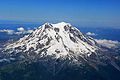
Washington Oregon California Categories:- Cascade Range
- Volcanoes of Shasta County, California
- United States National Park high points
- Lassen Volcanic National Park
- Subduction volcanoes
- Lava domes
- Cascade Volcanoes
- VEI-3 volcanoes
- Cirques


Wikimedia Foundation. 2010.