- Geography of Uzbekistan
-
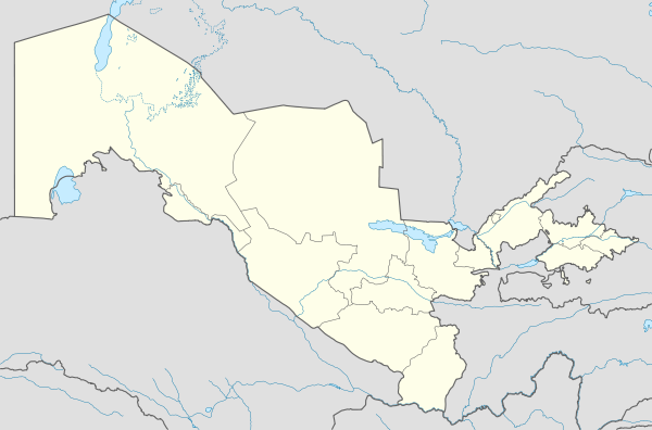
 BukhoroJizzakhNavoiyQarshiSamarkandGulistonTermizTashkentFerghanaAndijanNamanganUrgenchNukusMap of Uzbekistan
Uzbekistan is a country of Central Asia, located north of Turkmenistan and Afghanistan. With an area of 447,000 square kilometers (approximately the size of Spain or California), Uzbekistan stretches 1,425 kilometers from west to east and 930 kilometers from north to south. Bordering Turkmenistan to the southwest, Kazakstan to the north, and Tajikistan and Kyrgyzstan to the south and east, Uzbekistan is not only one of the larger Central Asian states but also the only Central Asian state to border all of the other four. Uzbekistan also shares a short border with Afghanistan to the south. As the Caspian Sea is an inland sea with no direct link to the oceans, Uzbekistan is one of only two "doubly landlocked" countries—countries completely surrounded by other landlocked countries. The other is Liechtenstein.
Contents
Topography and drainage
 Detailed map of Uzbekistan, 1995
 Topography of Uzbekistan
The physical environment of Uzbekistan is diverse, ranging from the flat, desert topography that comprises almost 80% of the country's territory to mountain peaks in the east reaching about 4,500 metres (14,800 ft) above sea level. The southeastern portion of Uzbekistan is characterized by the foothills of the Tian Shan mountains, which rise higher in neighboring Kyrgyzstan and Tajikistan and form a natural border between Central Asia and China. The vast Qizilqum (Turkic for "red sand"--Russian spelling Kyzyl Kum) Desert, shared with southern Kazakhstan, dominates the northern lowland portion of Uzbekistan. The most fertile part of Uzbekistan, the Fergana Valley, is an area of about 21,440 square kilometres (8,280 sq mi) directly east of the Qizilqum and surrounded by mountain ranges to the north, south, and east. The western end of the valley is defined by the course of the Syr Darya, which runs across the northeastern sector of Uzbekistan from southern Kazakhstan into the Qizilqum. Although the Fergana Valley receives just 100 to 300 millimetres (3.9 to 12 in) of rainfall per year, only small patches of desert remain in the center and along ridges on the periphery of the valley.
Water resources, which are unevenly distributed, are in short supply in most of Uzbekistan. The vast plains that occupy two-thirds of Uzbekistan's territory have little water, and there are few lakes. The two largest rivers feeding Uzbekistan are the Amu Darya and the Syr Darya, which originate in the mountains of Tajikistan and Kyrgyzstan, respectively. These rivers form the two main river basins of Central Asia; they are used primarily for irrigation, and several artificial canals have been built to expand the supply of arable land in the Fergana Valley and elsewhere. A shallow lake, Sarygamysh Lake, sits on the border with Turkmenistan.
Another important feature of Uzbekistan's physical environment is the significant seismic activity that dominates much of the country. Indeed, much of Uzbekistan's capital city, Tashkent, was destroyed in a major earthquake in 1966, and other earthquakes have caused significant damage before and since the Tashkent disaster. The mountain areas are especially prone to earthquakes.
Climate
Uzbekistan's climate is classified as continental, with hot summers and cool winters. Summer temperatures often surpass 40 °C (104 °F); winter temperatures average about −2 °C (28 °F), but may fall as low as −40 °C (−40 °F). Most of the country also is quite arid, with average annual rainfall amounting to between 100 and 200 millimeters (3.9 and 7.9 in) and occurring mostly in winter and spring. Between July and September, little precipitation falls, essentially stopping the growth of vegetation during that period.
Environmental problems
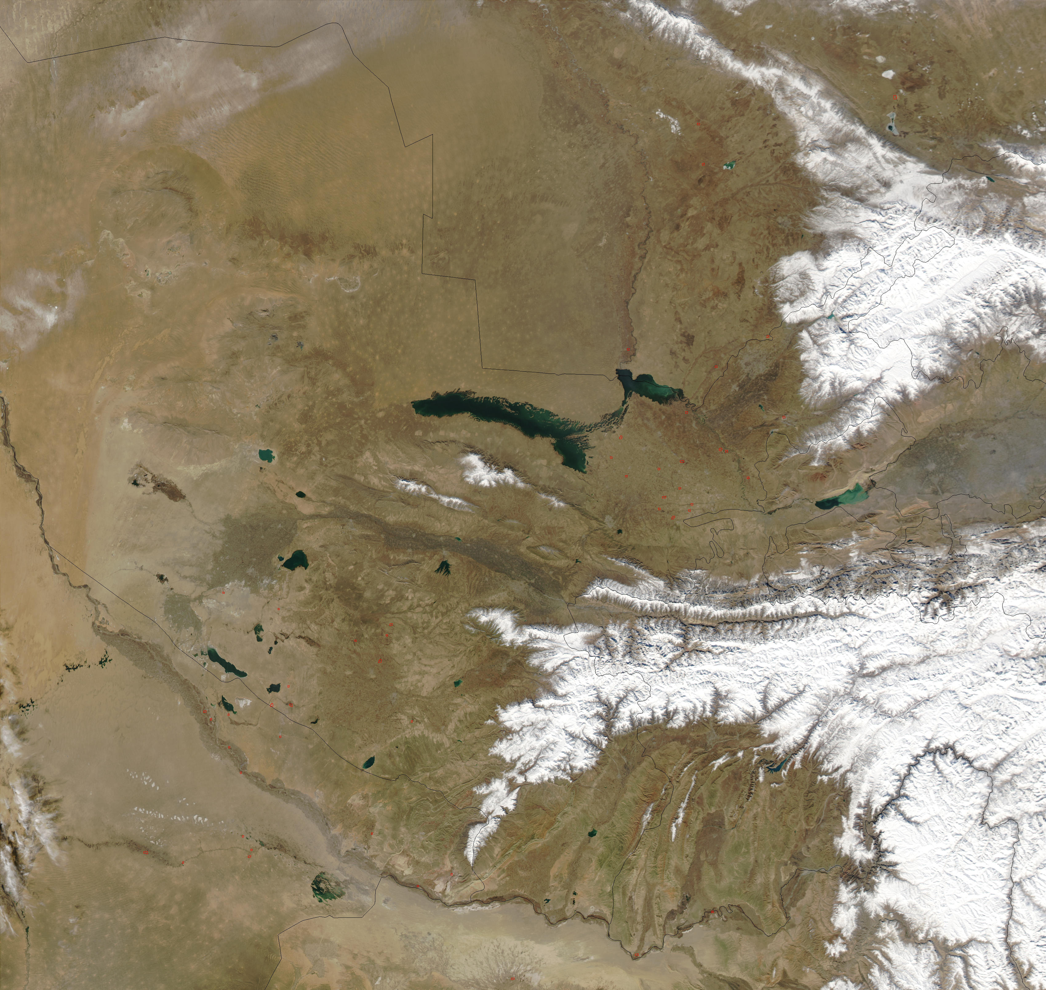
 Uzbekistan, February, 2003. Red dots indicate wildfires
Despite Uzbekistan's rich and varied natural environment, decades of environmental neglect in the Soviet Union have combined with skewed economic policies in the Soviet south to make Uzbekistan one of the gravest of the CIS's many environmental crises. The heavy use of agrochemicals, diversion of huge amounts of irrigation water from the two rivers that feed the region, and the chronic lack of water treatment plants are among the factors that have caused health and environmental problems on an enormous scale.
Environmental devastation in Uzbekistan is best exemplified by the catastrophe of the Aral Sea. Because of diversion of the Amu Darya and Syr Darya for cotton cultivation and other purposes, what once was the world's fourth largest inland sea has shrunk in the past thirty years to only about one-third of its 1960 volume and less than half its 1960 geographical size. The desiccation and salinization of the lake have caused extensive storms of salt and dust from the sea's dried bottom, wreaking havoc on the region's agriculture and ecosystems and on the population's health. Desertification has led to the large-scale loss of plant and animal life, loss of arable land, changed climatic conditions, depleted yields on the cultivated land that remains, and destruction of historical and cultural monuments. Every year, many tons of salts reportedly are carried as far as 800 kilometers away. Regional experts assert that salt and dust storms from the Aral Sea have raised the level of particulate matter in the Earth's atmosphere by more than 5%, seriously affecting global climate change.
The Aral Sea disaster is only the most visible indicator of environmental decay, however. The Soviet approach to environmental management brought decades of poor water management and lack of water or sewage treatment facilities; inordinately heavy use of pesticides, herbicides, defoliants, and fertilizers in the fields; and construction of industrial enterprises without regard to human or environmental impact. Those policies present enormous environmental challenges throughout Uzbekistan.
Natural hazards: NA
Environment - current issues: drying up of the Aral Sea is resulting in growing concentrations of chemical pesticides and natural salts; these substances are then blown from the increasingly exposed lake bed and contribute to desertification; water pollution from industrial wastes and the heavy use of fertilizers and pesticides is the cause of many human health disorders; increasing soil salination; soil contamination from agricultural chemicals, including DDT
Environment - international agreements:
party to: Biodiversity, Climate Change, Climate Change-Kyoto Protocol, Desertification, Endangered Species, Environmental Modification, Hazardous Wastes, Ozone Layer Protection
signed, but not ratified: none of the selected agreementsWater pollution
Large-scale use of chemicals for cotton cultivation, inefficient irrigation systems, and poor drainage systems are examples of the conditions that led to a high filtration of salinized and contaminated water back into the soil. Post-Soviet policies have become even more dangerous; in the early 1990s, the average application of chemical fertilizers and insecticides throughout the Central Asian republics was twenty to twenty-five kilograms per hectare, compared with the former average of three kilograms per hectare for the entire Soviet Union. As a result, the supply of fresh water has received further contaminants. Industrial pollutants also have damaged Uzbekistan's water. In the Amu Darya, concentrations of phenol and oil products have been measured at far above acceptable health standards. In 1989 the minister of health of the Turkmen SSR described the Amu Darya as a sewage ditch for industrial and agricultural waste substances. Experts who monitored the river in 1995 reported even further deterioration.
In the early 1990s, about 60% of pollution control funding went to water-related projects, but only about half of cities and about one-quarter of villages have sewers. Communal water systems do not meet health standards; much of the population lacks drinking water systems and must drink water straight from contaminated irrigation ditches, canals, or the Amu Darya itself.
According to one report, virtually all the large underground fresh-water supplies in Uzbekistan are polluted by industrial and chemical wastes. An official in Uzbekistan's Ministry of Environment estimated that about half of the country's population lives in regions where the water is severely polluted. The government estimated in 1995 that only 230 of the country's 8,000 industrial enterprises were following pollution control standards.
Air pollution
Poor water management and heavy use of agricultural chemicals also have polluted the air. Salt and dust storms and the spraying of pesticides and defoliants for the cotton crop have led to severe degradation of air quality in rural areas.
In urban areas, factories and auto emissions are a growing threat to air quality. Fewer than half of factory smokestacks in Uzbekistan are equipped with filtration devices, and none has the capacity to filter gaseous emissions. In addition, a high percentage of existing filters are defective or out of operation. Air pollution data for Tashkent, Farghona, and Olmaliq show all three cities exceeding recommended levels of nitrous dioxide and particulates. High levels of heavy metals such as lead, nickel, zinc, copper, mercury, and manganese have been found in Uzbekistan's atmosphere, mainly from the burning of fossil fuels, waste materials, and ferrous and nonferrous metallurgy. Especially high concentrations of heavy metals have been reported in Toshkent Province and in the southern part of Uzbekistan near the Olmaliq Metallurgy Combine. In the mid-1990s, Uzbekistan's industrial production, about 60% of the total for the Central Asian nations excluding Kazakhstan, also yielded about 60% of the total volume of Central Asia's emissions of harmful substances into the atmosphere. Because automobiles are relatively scarce, automotive exhaust is a problem only in Tashkent and Farghona.
Government environmental policy
The government of Uzbekistan has acknowledged the extent of the country's environmental problems, and it has made a commitment to address them in its Biodiversity Action Plan. But the governmental structures to deal with these problems remain confused and ill defined. Old agencies and organizations have been expanded to address these questions, and new ones have been created, resulting in a bureaucratic web of agencies with no generally understood commitment to attack environmental problems directly. Various nongovernmental and grassroots environmental organizations also have begun to form, some closely tied to the current government and others assuming an opposition stance. For example, environmental issues were prominent points in the original platform of Birlik, the first major opposition movement to emerge in Uzbekistan. By the mid-1990s, such issues had become a key concern of all opposition groups and a cause of growing concern among the population as a whole.
In the first half of the 1990s, many plans were proposed to limit or discourage economic practices that damage the environment. Despite discussion of programs to require payments for resources (especially water) and to collect fines from heavy polluters, however, little has been accomplished. The obstacles are a lack of law enforcement in these areas, inconsistent government economic and environmental planning, corruption, and the overwhelming concentration of power in the hands of a president who shows little tolerance of grassroots activity.
International donors and Western assistance agencies have devised programs to transfer technology and know-how to address these problems. But the country's environmental problems are predominantly the result of abuse and mismanagement of natural resources promoted by political and economic priorities. Until the political will emerges to regard environmental and health problems as a threat not only to the government in power but also to the very survival of Uzbekistan, the increasingly grave environmental threat will not be addressed effectively.
Area and boundaries
Area:
total: 447,400 km²
land: 425,400 km²
water: 22,000 km²Area - comparative: same size as Morocco, slightly smaller than Spain
Land boundaries:
total: 6,221 km
border countries: Afghanistan 137 km, Kazakhstan 2,203 km, Kyrgyzstan 1,099 km, Tajikistan 1,161 km, Turkmenistan 1,621 kmCoastline: 0 km
note: Uzbekistan includes the southern portion of the Aral Sea with a 420 km shoreline.Maritime claims: None. Uzbekistan is one of only two countries in the world that are doubly landlocked.
Elevation extremes:
lowest point: Sariqarnish Kuli -12 m
highest point: Khazret Sultan, 4,643 m, a peak in the Gissar Range, on the border with Tajikistan.Resources and land uses
Natural resources: natural gas, petroleum, coal, gold, uranium, silver, copper, lead and zinc, tungsten, molybdenum
Land use (2006 data):[1]
arable land: 9%
permanent crops: 1%
permanent pastures: 29%
other agricultural land: 11%
non-agricultural land: 50%Irrigated land in farms (2006 data):[1]
36,987 km² (92% of arable land)References
 This article incorporates public domain material from websites or documents of the Library of Congress Country Studies.
- This article incorporates public domain material from websites or documents of the CIA World Factbook.
Coordinates: 41°00′N 64°00′E / 41°N 64°E
Geography of Asia Sovereign
states- Afghanistan
- Armenia
- Azerbaijan
- Bahrain
- Bangladesh
- Bhutan
- Brunei
- Burma (Myanmar)
- Cambodia
- People's Republic of China
- Cyprus
- East Timor (Timor-Leste)
- Egypt
- Georgia
- India
- Indonesia
- Iran
- Iraq
- Israel
- Japan
- Jordan
- Kazakhstan
- North Korea
- South Korea
- Kuwait
- Kyrgyzstan
- Laos
- Lebanon
- Malaysia
- Maldives
- Mongolia
- Nepal
- Oman
- Pakistan
- Philippines
- Qatar
- Russia
- Saudi Arabia
- Singapore
- Sri Lanka
- Syria
- Tajikistan
- Thailand
- Turkey
- Turkmenistan
- United Arab Emirates
- Uzbekistan
- Vietnam
- Yemen
States with limited
recognition- Abkhazia
- Nagorno-Karabakh
- Northern Cyprus
- Palestine
- Republic of China (Taiwan)
- South Ossetia
Dependencies and
other territoriesClimate of Asia Sovereign
states- Afghanistan
- Armenia
- Azerbaijan
- Bahrain
- Bangladesh
- Bhutan
- Brunei
- Burma (Myanmar)
- Cambodia
- People's Republic of China
- Cyprus
- East Timor (Timor-Leste)
- Egypt
- Georgia
- India
- Indonesia
- Iran
- Iraq
- Israel
- Japan
- Jordan
- Kazakhstan
- North Korea
- South Korea
- Kuwait
- Kyrgyzstan
- Laos
- Lebanon
- Malaysia
- Maldives
- Mongolia
- Nepal
- Oman
- Pakistan
- Philippines
- Qatar
- Russia
- Saudi Arabia
- Singapore
- Sri Lanka
- Syria
- Tajikistan
- Thailand
- Turkey
- Turkmenistan
- United Arab Emirates
- Uzbekistan
- Vietnam
- Yemen
States with limited
recognition- Abkhazia
- Nagorno-Karabakh
- Northern Cyprus
- Palestine
- Republic of China (Taiwan)
- South Ossetia
Dependencies and
other territories- Christmas Island
- Cocos (Keeling) Islands
- Hong Kong
- Macau
Categories:


Wikimedia Foundation. 2010.