Mammoth Spring State Park
- Mammoth Spring State Park
-
Mammoth Spring State Park is a park surrounding Mammoth Spring. The park is located in Mammoth Spring, Arkansas.
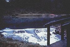
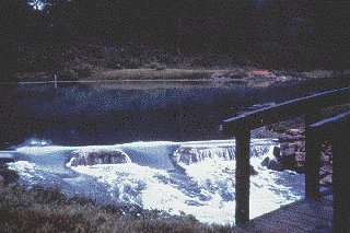
The park contains a hydroelectric dam, Mammoth Spring, a train museum including a Frisco caboose, a playground, and also allows visitors feed ducks and geese in the park.
History

The hydroelectric dam looking down the waterfall created by it.
Prior to 1957, the Mammoth Spring Cattle Sales Barn was co-owned and ran by local entrepreneur Kenneth "Bert" Bishop and his associate, roughly on the site of where the tourist information center now stands. Local farmers would routinely come to the site to sell livestock and other wares, such as Howard Green, who sold home-made walking sticks. Following this period in history, the State legislature voted to condemn the land and turn the spot into a state park. 1957, the park was established. The original Frisco Depot was restored in 1971. The depot now functions as a museum, containing artifacts and memorabilia.
External links
Coordinates: 36°29′49″N 91°32′02″W / 36.4969°N 91.5340°W / 36.4969; -91.5340
Categories:
- Arkansas state parks
- Museums in Fulton County, Arkansas
- Railroad museums in Arkansas
- Protected areas of Fulton County, Arkansas
Wikimedia Foundation.
2010.
Look at other dictionaries:
Mammoth Spring State Park — Quelltopf der Mammoth Spring Der Mammoth Spring State Park liegt unmittelbar neben der Ortschaft Mammoth Spring im Fulton County des US Bundesstaates Arkansas auf 161 m Höhe. Der 25 ha große State Park enthält mit Mammoth Spring die… … Deutsch Wikipedia
Mammoth Spring — Coordinates: 36°29′51″N 91°32′08″W / 36.4975°N 91.53556°W / 36.4975; 91.53556 … Wikipedia
Mammoth Cave National Park — Mammoth Cave redirects here. For other uses, see Mammoth Cave (disambiguation). Mammoth Cave National Park IUCN Category II (National Park) The Rotund … Wikipedia
Grand Gulf State Park — im August 2007 Der Grand Gulf State Park besteht aus einer Schlucht mit teilweise eingestürztem Höhlensystem, einer Felsbrücke und einem Fluss mit Schlucklöchern. Der 134 ha große State Park liegt in 2100 m Höhe etwa 10 km westlich … Deutsch Wikipedia
Marks' Mills State Park — Marks Mills Battlefield Park U.S. National Register of Historic Places U.S. National Historic Landmark … Wikipedia
Old Davidsonville State Park — Old Davidsonville State Historic Monument U.S. National Register of Historic Places … Wikipedia
Historic Washington State Park — Entrance sign off United States Highway 278 at Historic Washington State Park Historic Washington State Park is a museum village located off United States Highway 278 in Washington, Arkansas.[1] The state park opened in 1973 a … Wikipedia
Petit Jean State Park — Arkansas State Park View of Cedar Falls Named for: Petit Jean … Wikipedia
Crowley's Ridge State Park — The CCC Pavilion in Crowley s Ridge State Park … Wikipedia
Crater of Diamonds State Park — IUCN Category III (Natural Monument) … Wikipedia