- Geography of the United Arab Emirates
-

Life in the UAECuisine
Culture
Communications
Cinema
Demography
Education
Geography
Human rights
Military
Media
Politics
Music
Transport
Religion
Sport
Tourismedit box The United Arab Emirates is situated in Southwest Asia, bordering the Gulf of Oman and the Persian Gulf, between Oman and Saudi Arabia; it is in a strategic location along northern approaches to the Strait of Hormuz, a vital transit point for world crude oil. The UAE lies between 22°50′ and 26° north latitude and between 51° and 56°25′ east longitude. It shares a 19-kilometer border with Qatar on the northwest (according to the UAE), a 530-kilometer border with Saudi Arabia on the west, south, and southeast, and a 450-kilometer border with Oman on the southeast and northeast. The land border with Qatar in the Khawr al Udayd area is a source of ongoing dispute (in fact, whether it even shares a land border with Qatar is in dispute). The total area of the UAE is approximately 83,600 square kilometers. The country's exact size is unknown because of disputed claims to several islands in the Persian Gulf, because of the lack of precise information on the size of many of these islands, and because most of its land boundaries, especially with Saudi Arabia, remain undemarcated. The largest emirate, Abu Dhabi, accounts for 87 percent of the UAE's total area (67,340 square kilometers). The smallest emirate, Ajman, encompasses only 259 square kilometers (see figure).
-

Map of United Arab Emirates
-

Emirates of the UAE
-

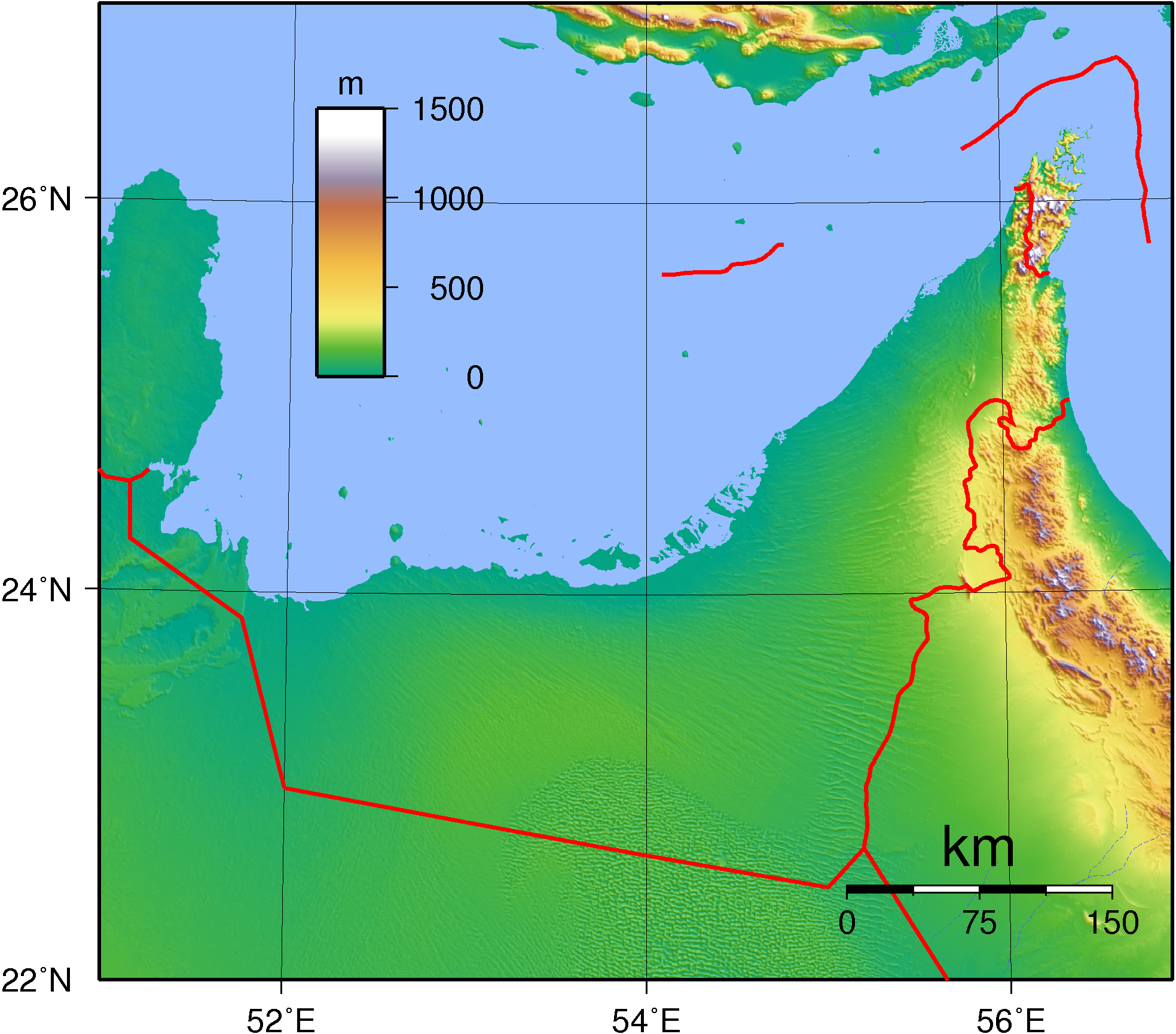
Topography of the UAE
-

Satellite image of the UAE
Geographic coordinates: 24°00′N 54°00′E / 24°N 54°E
Contents
Physiography and boundaries
The UAE stretches for more than 650 kilometers along the southern shore of the Persian Gulf. Most of the coast consists of salt pans that extend far inland. The largest natural harbor is at Dubai, although other ports have been dredged at Abu Dhabi, Sharjah, and elsewhere. Numerous islands are found in the Persian Gulf, and the ownership of some of them has been the subject of international disputes with both Iran and Qatar. The smaller islands, as well as many coral reefs and shifting sandbars, are a menace to navigation. Strong tides and occasional windstorms further complicate ship movements near the shore.
The UAE also extends for about 90 kilometers along the Gulf of Oman, an area known as the Al Batinah coast. The Al Hajar al Gharbi (Western Al Hajar) Mountains, rising in places to 2,500 meters, separate the Al Batinah coast from the rest of the UAE. Beginning at the UAE-Oman border on the Persian Gulf coast of the Ras Musandam (Musandam Peninsula), the Al Hajar al Gharbi Mountains extend southeastward for about 150 kilometers to the southernmost UAE-Oman frontier on the Gulf of Oman. The range continues as the Al Hajar ash Sharqi (Eastern Al Hajar) Mountains for more than 500 kilometers into Oman. The steep mountain slopes run directly to the shore in many places. Nevertheless, there are small harbors at Dibba Al-Hisn, Kalba, and Khor Fakkan on the Gulf of Oman. In the vicinity of Al Fujayrah, where the mountains do not approach the coast, there are sandy beaches.
These northern emirates on the Persian Gulf and Gulf of Oman are part of the Gulf of Oman desert and semi-desert ecoregion. [1]
South and west of Abu Dhabi, vast, rolling sand dunes merge into the Rub' al Khali (Empty Quarter) of Saudi Arabia. The desert area of Abu Dhabi includes two important oases with adequate underground water for permanent settlements and cultivation. The extensive Al Liwa Oasis is in the south near the undefined border with Saudi Arabia, and about 100 kilometers to the northeast is the Al Buraymi Oasis, which extends on both sides of the Abu Dhabi-Oman border.
Prior to withdrawing from the area in 1971, Britain delineated the internal borders among the seven emirates in order to preempt territorial disputes that might hamper formation of the federation. In general, the rulers of the emirates accepted the British intervention, but in the case of boundary disputes between Abu Dhabi and Dubayy, and also between Dubayy and Sharjah, conflicting claims were not resolved until after the UAE became independent. The most complicated borders were in the Al Hajar al Gharbi Mountains, where five of the emirates contested jurisdiction over more than a dozen enclaves.
Climate
See also: Climate
The climate of the UAE generally is hot and dry. The hottest months are July and August, when average maximum temperatures reach above 40 °C (104.0 °F) on the coastal plain. In the Al Hajar al Gharbi Mountains, temperatures are considerably cooler, a result of increased altitude. Average minimum temperatures in January and February are between 10 and 14 °C (50 and 57.2 °F). During the late summer months, a humid southeastern wind known as the sharqi makes the coastal region especially unpleasant. The average annual rainfall in the coastal area is fewer than 120 mm (4.7 in), but in some mountainous areas annual rainfall often reaches 350 mm (13.8 in). Rain in the coastal region falls in short, torrential bursts during the summer months, sometimes resulting in floods in ordinarily dry wadi beds. The region is prone to occasional, violent dust storms, which can severely reduce visibility. The Jebel Jais mountain cluster in Ras al Khaimah has experienced snow only twice since records began.[2]
Flora and fauna
In the oases grow date palms, acacia and eucalyptus trees. In the desert the flora is very sparse and consists of grasses and thornbushes. The indigenous fauna had come close to extinction because of intensive hunting, which has led to a conservation program on Bani Yas island initiated by Sheikh Zayed bin Sultan Al Nahyan in the 1970s, resulting in the survival of, for example, Arabian oryx and leopards. Coastal fish consist mainly of mackerel, perch and tuna, as well as sharks and whales.
Area and land boundaries
Area:
total: 82,880 km²
land: 82,880 km²
water: 0 km²Land boundaries:
total: 867 km
border countries: Oman 410 km, Saudi Arabia 457 kmCoastline: 1,318 km
Maritime claims:
contiguous zone: 24 nmi (27.6 mi; 44.4 km)
continental shelf: 200 nmi (230.2 mi; 370.4 km) or to the edge of the continental margin
exclusive economic zone: 200 nmi (230.2 mi; 370.4 km)
territorial sea: 12 nmi (13.8 mi; 22.2 km)Elevation extremes:
lowest point: Persian Gulf 0 m
highest point: Unnamed 1,910 m knoll just across the border from Jabal Bil Ays in Oman.Resources and land use
Natural resources: petroleum, natural gas
Land use:
arable land: 0.77%
permanent crops: 0%
permanent pastures: 2%
forests and woodland: 3.8%
other: 98% (1993 est.)Irrigated land: 50 km² (1993 est.)
Environmental concerns
Natural hazards: frequent sand and dust storms
Environment - current issues: lack of natural freshwater resources being overcome by desalination plants; desertification; beach pollution from oil spills
Environment - international agreements:
party to: Climate Change, Desertification, Endangered Species, Hazardous Wastes, Marine Dumping, Ozone Layer Protection
signed, but not ratified: Biodiversity, Law of the SeaSee also
- United Arab Emirates
- Saudi Arabia - UAE border dispute
References
- ^ http://www.worldwildlife.org/wildworld/profiles/terrestrial/at/at1306_full.html
- ^ Nasouh Nazzal (2009-01-24). "Heavy snowfall on Ras Al Khaimah's Jebel Jais mountain cluster". Gulf News. http://www.gulfnews.com/nation/General/10278477.html. Retrieved 2009-01-31.
 This article incorporates public domain material from websites or documents of the Library of Congress Country Studies.
- This article incorporates public domain material from websites or documents of the CIA World Factbook.
 United Arab Emirates topics
History Politics Emirates · Federal National Council · Military of the United Arab Emirates · President · Prime Minister · Rulers · Elections · 2006 election · Foreign relations · Military · Foreign Aid · Law · Human Rights · LGBT rights · Hizb ut-TahrirGeography Cities · Towns and Villages · Climate · Resources and land use · Environmental concerns · Land DisputesEconomy Demographics List of United Arab Emiratis (Emirati people) · Language · Education · Religion · Health · Human rights · Women · Sunni Muslim · Shi'a MuslimCulture Transport Highways · Railways · Ports and Harbors · Airlines · Water TransportCommunication Radio and Television · Telecommunication Companies · Media · Telecommunications Regulatory Authority · Internet domainTourism Symbols Topics · Portal Geography of Asia Sovereign
statesAfghanistan · Armenia · Azerbaijan · Bahrain · Bangladesh · Bhutan · Brunei · Burma (Myanmar) · Cambodia · People's Republic of China · Cyprus · East Timor (Timor-Leste) · Egypt · Georgia · India · Indonesia · Iran · Iraq · Israel · Japan · Jordan · Kazakhstan · North Korea · South Korea · Kuwait · Kyrgyzstan · Laos · Lebanon · Malaysia · Maldives · Mongolia · Nepal · Oman · Pakistan · Philippines · Qatar · Russia · Saudi Arabia · Singapore · Sri Lanka · Syria · Tajikistan · Thailand · Turkey · Turkmenistan · United Arab Emirates · Uzbekistan · Vietnam · Yemen
States with limited
recognitionAbkhazia · Nagorno-Karabakh · Northern Cyprus · Palestine · Republic of China (Taiwan) · South Ossetia
Dependencies and
other territoriesClimate of Asia Sovereign
statesAfghanistan · Armenia · Azerbaijan · Bahrain · Bangladesh · Bhutan · Brunei · Burma (Myanmar) · Cambodia · People's Republic of China · Cyprus · East Timor (Timor-Leste) · Egypt · Georgia · India · Indonesia · Iran · Iraq · Israel · Japan · Jordan · Kazakhstan · North Korea · South Korea · Kuwait · Kyrgyzstan · Laos · Lebanon · Malaysia · Maldives · Mongolia · Nepal · Oman · Pakistan · Philippines · Qatar · Russia · Saudi Arabia · Singapore · Sri Lanka · Syria · Tajikistan · Thailand · Turkey · Turkmenistan · United Arab Emirates · Uzbekistan · Vietnam · Yemen
States with limited
recognitionAbkhazia · Nagorno-Karabakh · Northern Cyprus · Palestine · Republic of China (Taiwan) · South Ossetia
Dependencies and
other territoriesChristmas Island · Cocos (Keeling) Islands · Hong Kong · Macau
Categories: -


Wikimedia Foundation. 2010.