- Northern Virginia trolleys
-
Northern Virginia trolleys
Terminal at Mount VernonOperation Began operation 1892 Ended operation January 18, 1932 Technical Track gauge (?) Minimum radius of curvature (?) Electrification (?) System map 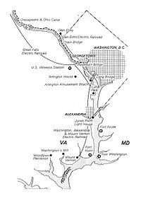
The earliest electric railway, or streetcar line, in Northern Virginia opened in 1892. At their peak, when merged into a single interurban system (the Washington-Virginia Railway), the successors of this and several other lines ran between downtown Washington, D.C., Rosslyn and Arlington Junction – present day Crystal City – and out to Mount Vernon, Fairfax City and Nauck (in Arlington County).[1][2][3][4] Electric rail also went west from Georgetown and Rosslyn on the Washington and Old Dominion Railway's Bluemont Division via Leesburg to the town of Bluemont at the base of the Blue Ridge Mountains and on the W&OD's Great Falls Division via Cherrydale and McLean to Great Falls Park. Despite early success, the streetcars were unable to compete with the automobile and with each other, and, plagued with management and financial problems, ceased operations in the 1930s and 1940s.
Northern Virginia's trolleys were originally operated by three different companies and were never integrated with the Washington streetcar network. The lines were laid when most of the area was undeveloped, and so the trains ran mostly on separate rights-of-way.
The lines of the Washington-Virginia Railway terminated in downtown Washington, D.C., at 12th and D Streets, NW, (within the present Federal Triangle between Pennsylvania Avenue and the Federal Triangle Metrorail Station) after crossing the Potomac River near the site of the present 14th Street bridges over the Long Bridge and, beginning in 1906, the Highway Bridge. The W&OD Railway entered Georgetown after crossing the Potomac River from Rosslyn over the Aqueduct Bridge.
The Washington-Virginia Railway and the W&OD Railway used adjacent terminals in Rosslyn near the present location of the Key Bridge Marriott Hotel. After the Francis Scott Key Bridge replaced the Aqueduct Bridge in 1923, all of the Virginia lines terminated in Rosslyn, but Washington streetcars now crossed the river into Rosslyn where there was a turnaround loop. There, passengers could transfer to the Virginia lines.
Contents
- 1 Washington-Virginia Railway
- 2 Washington and Old Dominion Railway
- 3 See also
- 4 Notes
- 5 References
- 6 External links
Washington-Virginia Railway
Washington, Alexandria, and Mount Vernon Railway
Washington-Mount Vernon line
Opened in 1892 between Alexandria and Mount Vernon, the Washington, Alexandria, and Mount Vernon Railway was extended in 1896 across the Long Bridge to downtown Washington, D.C., terminating at 12th and D Streets, NW, near the present location of the Federal Triangle Metro Station. The streetcars ran in Arlington near and along the present routes of Interstate 395 (I-395) and S. Eads Street, travelling largely on the grade of a towpath on the west side of the defunct Alexandria Canal. Near Arlington's southern border, the railroad and its affiliates constructed an amusement park (Luna Park) and a rail yard containing a car barn and power plant.
After crossing Four Mile Run into Alexandria, the streetcars ran along the present route of Commonwealth Avenue until reaching the city's Old Town area at King Street. The St. Elmo station (located on the present route of Commonwealth Avenue in the Del Ray neighborhood of Alexandria) allowed passenger transfers with the Bluemont branch of the Southern Railway and later, with the Bluemont Division of the W&OD Railway, which crossed over the Mount Vernon line on a bridge near the station.
At Mount Vernon, when the electric railway began service, the estate's proprietors insisted that only a modest terminal be constructed next to the trolley turnaround. They were afraid that the dignity of the site would be marred by unrestricted commercial development and persuaded financier Jay Gould to purchase and donate thirty-three acres outside the main gate for protection.
By 1906, the railway had transported 1,743,734 passengers along its routes with 92 daily trains. During World War I, the line was extended to Camp Humphreys (now Fort Belvoir).
In 1913, the Washington, Alexandria, and Mount Vernon Railway merged with the Washington, Arlington & Falls Church Railroad to form the Washington-Virginia Railway. The trolley company went into receivership in 1923 when buses became the dominant form of local public transportation.
In 1927, the two railways were separated and sold at auction. The last trolleys of the line ran on January 18, 1932. Later that year the tracks were removed when some of the right-of-way was used for the George Washington Memorial Parkway. The path of the trolley turnaround at Mount Vernon remains as a traffic circle at the south end of the Parkway, while the former rail yard in southern Arlington now serves as a Metrobus yard.
Stations
The stations on the Washington-Mount Vernon Line of the Washington, Alexandria, and Mount Vernon Railway were (with locations of sites in 2008):
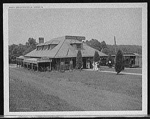
 Washington, Alexandria, and Mount Vernon Electric Railway near Dyke Marsh with station in background. 1930
Station Location[5] Jurisdiction Miles from
Washington Terminal[6]Notes Coordinates Camp Humphreys Fort Belvoir Fairfax County Mount Vernon South side of traffic circle at Mount Vernon Estate Fairfax County 15.8 38°42′39″N 77°05′12″W / 38.71078°N 77.086591°W Deenwood Fairfax County Miller Fairfax County Riverside Wittington Boulevard Fairfax County 14.7 38°43′16″N 77°04′08″W / 38.721245°N 77.068856°W Hunter Fairfax County 14.2 North Mount Vernon Fairfax County Grassymead Fairfax County 13.1 Snowden East Boulevard Drive Fairfax County 13.1 Herbert Springs East Boulevard Drive and Herbert Springs Road Fairfax County 12.9 38°43′16″N 77°04′08″W / 38.721245°N 77.068856°W Arcturus East Boulevard Drive and Arcturus Lane Fairfax County 12.8 38°44′14″N 77°02′48″W / 38.737289°N 77.046669°W Wellington East Boulevard Drive Fairfax County 12.5 38°44′22″N 77°02′50″W / 38.7395069°N 77.0471728°W Bellmont Fairfax County 12.1 Happy Home Fairfax County Warwick Fairfax County Dyke Fairfax County 11.3 Oaks Fairfax County New Alexandria Fairfax County 9.6 Alexandria Prince and Royal Streets City of Alexandria 7.7 38°48′13″N 77°02′38″W / 38.803503°N 77.043868°W Rosemont Rosemont Avenue and Commonwealth Avenue City of Alexandria 38°48′34″N 77°03′48″W / 38.809416°N 77.063212°W Braddock Braddock Road and Commonwealth Avenue City of Alexandria 6.0 38°48′59″N 77°03′45″W / 38.816288°N 77.062526°W North Braddock Commonwealth Avenue City of Alexandria Lloyd Windsor Avenue and Commonwealth Avenue City of Alexandria 5.7 38°49′27″N 77°03′45″W / 38.824263°N 77.062633°W Del Ray Del Ray Avenue and Commonwealth Avenue City of Alexandria 5.6 38°49′33″N 77°03′43″W / 38.825834°N 77.061946°W Mount Ida Mount Ida Avenue and Commonwealth Avenue City of Alexandria Historical marker near site of station: The Electric Railway[7][8] 38°49′42″N 77°03′39″W / 38.828266°N 77.060764°W St. Asaph Commonwealth Avenue, between Forrest St. and Ancell St. City of Alexandria 5.6 Served St. Asaph racetrack. (1894-1905)[9]
Historical marker near site of station: St. Asaph Racetrack[9][10]38°49′47″N 77°03′36″W / 38.829712°N 77.059929°W Hume Intersection of Hume Avenue, Mount Vernon Avenue and Commonwealth Avenue City of Alexandria Historical marker near site of station: Mount Vernon Avenue[11][12] 38°49′51″N 77°03′35″W / 38.830749°N 77.059586°W St. Elmo Commonwealth Avenue near Ashby St. City of Alexandria 4.8 Crossing of W&OD Railway's Bluemont Division
Historical marker near site of station: The Bluemont Line[13][14]38°49′59″N 77°03′32″W / 38.833103°N 77.058795°W Four Mile Run Near present intersection of S. Glebe Road and S. Eads St. Arlington County 4.1 38°50′33″N 77°03′17″W / 38.842482°N 77.054822°W Car Barn In bus yard east of S. Eads St. Arlington County Formerly in rail yard 38°50′40″N 77°03′13″W / 38.844333°N 77.053739°W Luna Park West side of Eads St. Arlington County Adjacent to amusement park in present site of sewage treatment plant 38°50′40″N 77°03′13″W / 38.844333°N 77.053739°W Aurora Hills S. Eads St. Arlington County Virginia Highlands 22nd St. S. and S. Eads St. Arlington County 38°51′15″N 77°03′12″W / 38.854163°N 77.053229°W Addison 18th St. S. and S. Eads St. Arlington County 3.2 38°51′27″N 77°03′11″W / 38.8574133°N 77.0530951°W Arlington Junction Between Army-Navy Drive and 12th St. S and between S. Eads St. and Jefferson Davis Highway (U.S. Route 1)] Arlington County 2.7 Junction with South Arlington branch of Washington, Arlington & Falls Church Railroad and East Arlington Branch of Washington, Alexandria, and Mount Vernon Railway 38°51′50″N 77°03′12″W / 38.86393°N 77.053444°W South Washington Near I-395 Arlington County 38°52′00″N 77°02′56″W / 38.866762°N 77.048879°W Alexander Island Near I-395 between Boundary Channel Drive and George Washington Memorial Parkway Arlington County 2.1 38°52′15″N 77°02′40″W / 38.870788°N 77.044458°W Washington Terminal West side of 12th St. NW between Federal Triangle Metro Station and Pennsylvania Avenue NW District of Columbia 0 At corner of 13 & 1/2 Street NW and Pennsylvania Avenue NW in 1902.[6] 38°53′41″N 77°01′41″W / 38.894603°N 77.028161°W Remnants of the Washington-Mount Vernon Line
- Roads
- Wittington Boulevard, Fairfax County. Coordinates: 38°43′17″N 77°04′07″W / 38.721311°N 77.068577°W
- East Boulevard Drive, Fairfax County. Coordinates: 38°44′18″N 77°02′49″W / 38.738362°N 77.046913°W
- Potomac Avenue, Fairfax County. Coordinates: 38°46′40″N 77°03′24″W / 38.777741°N 77.056689°W
- Commonwealth Avenue, Alexandria. Coordinates: 38°49′28″N 77°03′45″W / 38.824513°N 77.062547°W
- South Eads Street, Arlington. Coordinates: 38°51′04″N 77°03′13″W / 38.851147°N 77.053653°W
- Metrobus yard
- Former rail yard at S. Eads Street (east side) and S. Glebe Road (north side), Arlington. Coordinates: 38°50′40″N 77°03′13″W / 38.844316°N 77.053744°W
- Traffic circle
- Former trolley turnaround at Mount Vernon estate, Fairfax County. Coordinates: 38°42′41″N 77°05′10″W / 38.711283°N 77.086137°W
East Arlington branch
The Washington, Alexandria, and Mount Vernon Railway constructed a branch line that traveled to the Virginia end of the Aqueduct Bridge in Rosslyn from a point named Arlington Junction on the railroad's Alexandria-Mount Vernon line. Along most of its route, the branch traveled along a section of Arlington Ridge Road that is now within Arlington National Cemetery.
Construction of this branch permitted visitors from Washington, D.C., to reach the Cemetery by rail for the first time. However, after leaving the trolley at the Cemetery's Sheridan Gate, the visitors needed to ascend a steep hill to reach most of the Cemetery's well-known features and burial sites.
Stations
The stations of the East Arlington branch were (with locations of sites in 2008):
Station Location[5] Jurisdiction Notes Coordinates Rosslyn N. Lynn St. near Key Bridge Marriott Hotel Arlington County East of W&OD Railway station. 1925 photo[15] 38°53′59″N 77°04′15″W / 38.899598°N 77.070934°W Arlington Arlington National Cemetery Arlington County Outside of former Sheridan Gate of Arlington National Cemetery (location now inside of cemetery) 38°52′49″N 77°04′03″W / 38.880377°N 77.067547°W Queen City Arlington National Cemetery Arlington County 38°52′30″N 77°04′03″W / 38.874897°N 77.067504°W Mount Vernon Junction Near present east crossing of Columbia Pike (Virginia Route 244) and Washington Boulevard (Virginia Route 27) Arlington County Junction with South Arlington branch of Washington, Arlington & Falls Church Railroad 38°52′11″N 77°03′44″W / 38.869719°N 77.062204°W Relee I-395 between S. Fern St. and S. Eads St. Arlington County 38°51′56″N 77°03′20″W / 38.865642°N 77.055531°W Arlington Junction Between Army-Navy Drive and 12th St. S and between S. Eads St. and Jefferson Davis Highway (U.S. Route 1) Arlington County Junction with Washington-Mount Vernon line 38°51′50″N 77°03′12″W / 38.86393°N 77.053444°W Washington, Arlington & Falls Church Railroad
During its forty years of life, this interurban trolley company operated under a variety of names, as it repeatedly expanded, reorganized or contracted (voluntarily or involuntarily).
Washington & Arlington — 1892–1896
The system started in 1892, under the name Washington & Arlington Railway, as a horsecar line with tracks from Rosslyn up the hill to Ft. Myer. In late 1895 it was electrified.
Washington, Arlington & Falls Church — 1896–1913
In 1896, track was laid from Rosslyn through Clarendon and Ballston to Falls Church and the name was changed to the Washington, Arlington & Falls Church (WA&FC). The track to Fort Myer was extended through Penrose in 1900 and to Nauck, just north of Four Mile Run, in 1901. That same year saw the opening of about a mile of additional track, extending from East Falls Church to West Falls Church. Work on a far more ambitious extension began at West Falls Church in 1903, and the line eventually reached Fairfax City in 1904.
Washington - Virginia — 1913–1927
In 1913, the WA&FC and Washington, Alexandria & Mt. Vernon were merged to form the Washington - Virginia (W-V) Railway. The company fell upon hard times and in 1924 declared bankruptcy. In 1927, the two companies were split and sold at auction.
Arlington & Fairfax — 1927–1936
The Arlington & Fairfax was organized by local governments to take control of the WA&FC line after the W-V went bankrupt. In 1932, the company lost the right to travel into D.C., and, on January 17, 1932, the last Arlington & Fairfax streetcar departed from 12th & D Streets, NW, abandoning all service in Washington, D.C.
Arlington & Fairfax Auto Railroad — 1936–1939
In 1936, the company was sold to Detroit's Evans Products Company, an innovative railway and automotive industry supplier that had developed the first version of the present hy-rail system called auto-railers, small buses that can run on rails on flanged wheels or on roads with rubber. In 1937, Evans replaced the trolleys with auto-railers. On rail, they went to Rosslyn where they were intended to switch to tires and cross the Key Bridge into Georgetown, eliminating the change in Rosslyn, but Capital Transit prevented that service by objecting that its franchise gave it exclusive service across the bridge. The auto-railers last ran in September 1939.
Nauck line (Fort Myer line)
The Nauck line (Fort Myer line) ran south from Rosslyn through Fort Myer to an originally undeveloped area in South Arlington near Four Mile Run. After leaving the railroad's Rosslyn terminal near the Aqueduct Bridge, the line travelled south along the present routes of N. Lynn Street and N. Meade Street to reach the Fort. The line then turned to the southwest and entered the Fort near today’s Wright Gate. Within the Fort, trolleys on the line climbed a hill along the present route of McNair Road near the western wall of Arlington National Cemetery to reach a station (Arlington Fort Myer) located within the Fort at the present intersection of McNair Road and Lee Avenue, near the Cemetery's Fort Myer Gate (Chapel Gate of Fort Myer).
After disembarking at the Arlington Fort Myer station, visitors could enter the Cemetery at its highest elevation, thus avoiding the ascent required when entering the Cemetery through the Sheridan Gate from the East Arlington branch. After the East Arlington branch discontinued service in 1921, the Nauck line continued to carry visitors to the Cemetery.
The line then continued through Fort Myer, exiting the Fort a short distance north of the Fort's Hatfield Gate. When crossing the present path of Washington Boulevard (Virginia Route 27) south of Arlington Boulevard (U.S. Route 50), the line met at its Hatfield station (Hatfield Junction) the South Arlington branch of the railroad's Fairfax line.
After leaving Hatfield, the Nauck line followed the present routes of S. Uhle Street and Walter Reed Drive before travelling downhill on S. Kenmore Street to end at a railway turntable at 24th Road S. and S. Kenmore Street. The line terminated a short distance north of the Cowdon station of the Southern Railway, and later, of the W&OD Railway's Bluemont Division.
Stations
The stations of the Nauck line were (with locations of sites in 2008):
 Arlington Fort Myer trolley station. Post hospital at left.
Station Location[5] Jurisdiction Notes Coordinates Rosslyn N. Lynn St. near Key Bridge Marriott Hotel Arlington County East of W&OD Railway station 38°53′59″N 77°04′15″W / 38.899598°N 77.070934°W Signal Corps N. Meade Street immediately west of the Netherlands Carillon Arlington County 38°53′16″N 77°04′18″W / 38.88791°N 77.071731°W Fort Myer Steps Marshall Drive and Stewart Road, Fort Myer Arlington County 38°53′10″N 77°04′31″W / 38.886006°N 77.075229°W Arlington Fort Myer McNair Road and Lee Avenue, Fort Myer Arlington County Near Fort Myer Gate of Arlington National Cemetery (Chapel Gate of Fort Myer) 38°52′50″N 77°04′45″W / 38.880602°N 77.0791018°W Hatfield (Hatfield Junction) Washington Blvd. (Virginia Route 120) near S. Uhle St. and Arlington Blvd. (U.S. Route 50) Arlington County Junction with South Arlington branch 38°52′26″N 77°04′55″W / 38.873895°N 77.081838°W Hunter S. Uhle St. and S. Walter Reed Drive, near S. Courthouse Road Arlington County 38°52′22″N 77°04′58″W / 38.872903°N 77.082656°W Penrose 2312 2nd St. S. (2nd St. S. and S. Uhle St.) Arlington County 38°52′17″N 77°05′02″W / 38.871502°N 77.084021°W Fulcher Near S. Barton St. and 3rd St. S. Arlington County 38°52′13″N 77°05′07″W / 38.870203°N 77.085389°W Munson Near S. Cleveland St. and 5th St. S. Arlington County 38°52′09″N 77°05′11″W / 38.869034°N 77.086515°W Bradbury Near S. Walter Reed Drive and S. Filmore St. Arlington County 38°52′04″N 77°05′16″W / 38.867797°N 77.087824°W Arlington Columbia S. Walter Reed Drive and Columbia Pike Arlington County 38°52′04″N 77°05′16″W / 38.867797°N 77.087824°W Petty S. Walter Reed Drive Arlington County Fox S. Walter Reed Dr. and 16th Road S. (near S. Glebe Road (Virginia Route 120)) Arlington County 38°51′21″N 77°05′19″W / 38.855851°N 77.088591°W Fort Berry S. Kenmore St. and 19th St. S. Arlington County 38°51′12″N 77°05′17″W / 38.853376°N 77.08795°W Corbett S. Kenmore St. Arlington County 38°51′05″N 77°05′12″W / 38.851506°N 77.086687°W Peyton S. Kenmore St. and 22 St. S. Arlington County 38°50′59″N 77°05′08″W / 38.849835°N 77.085657°W Nauck/Green Valley Kenmore St. and 24th Road S. Arlington County Historical marker near site of station: Nauck: A Neighborhood History[16] 38°50′54″N 77°05′05″W / 38.848469°N 77.084791°W Remnants of the Nauck line
- Station
- 2nd Street S., Arlington, the former Penrose Station now a private residence. Coordinates: 38°52′17″N 77°05′02″W / 38.871467°N 77.084021°W
- Roads
- S. Uhle St. between S. Courthouse Road and 2nd St. S., Arlington. Coordinates: 38°52′21″N 77°04′59″W / 38.872471°N 77.083168°W
- Walter Reed Drive between Columbia Pike and 13th St. S.], Arlington. Coordinates: 38°52′21″N 77°04′59″W / 38.872471°N 77.083168°W
- S. Kenmore St., Arlington. Coordinates: 38°51′02″N 77°05′10″W / 38.850537°N 77.086043°W
Fairfax line
The Fairfax line traveled from a terminus in front of the old Fairfax County Courthouse[17][18] in Fairfax City through Oakton, Vienna, Dunn Loring, Falls Church and Ballston to downtown Washington, D.C., and Rosslyn by way of Clarendon.
Trolleys of the Fairfax line began their trips at the old Courthouse, located at the southwest corner of Chain Bridge Road (now part of Virginia Route 123) and Main Street (now part of Virginia Route 236). The cars first ran westward along Main Street and then turned north at the site of the Fairfax Electric Depot (the terminus of the line until the depot burned in 1907) onto the present route of Railroad Avenue.[19] After crossing the present route of Lee Highway (U.S. Routes 50 and 29), the line crossed Chain Bridge Road. The line then traveled northeast through Fairfax County a short distance east of Chain Bridge Road, passed through Oakton (where its station remains and is preserved by the Northern Virginia Conservation Trust), and reached the town of Vienna.
The line continued northeast in Vienna about a block southeast of Maple Avenue W. Trolleys on the line crossed Center Avenue S, turned to the northwest on a wye and crossed Maple Avenue E. After leaving the wye, the trolleys stopped at the line's Vienna station.
The Fairfax line's Vienna station was located in the center of town on the southeast side of Church Street NE, a short distance southeast of the tracks of the Southern Railway's Bluemont Branch, which became the W&OD Railway's Bluemont Division in 1912. The Southern's Vienna station (which remains intact on the southwest side of the W&OD Trail) was a block northwest of the Fairfax line's station.
As the Fairfax line's tracks ended near Church Street, trolleys left their station by reversing direction. They then recrossed Maple Avenue E and traveled southeast through a second leg of the wye that paralleled the Southern's tracks, with which there was an interchange. Freight and work cars usually bypassed the station and avoided reversing by turning from the northeast to the southeast on the third leg of the wye.[20]
After leaving the wye, the line continued east in Vienna on Ninovan Road, paralleling the Southern's route. The line then crossed the Southern's tracks on a bridge built in 1904. After the crossing, the line traveled east along the present routes of Electric Avenue, Railroad Street and Helena Drive in Fairfax County until it reached the City of Falls Church.
The line continued eastward through Falls Church, following the present route of Lincoln Avenue until it reached the present Arlington County (formerly named Alexandria County). In Arlington, the line traveled eastward along the route of N. Fairfax Drive, which Interstate 66 (I-66) has partially replaced. Between 1912 and its closing, the line traveled under a plate girder bridge at Waycroft that the W&OD Railway constructed near the west end of Ballston for its Thrifton-Bluemont Junction connecting line.
The line then passed a car barn, a rail yard, workshops, electrical substation, general offices and a station that the Washington, Arlington and Falls Church Railroad had built in 1910 at Lacey (currently the intersection of N. Glebe Road and N. Fairfax Drive in Ballston). After traveling eastward through Ballston on the present route of N. Fairfax Drive, the line reached Clarendon, where it branched.
The North Arlington branch continued to follow the route of Fairfax Drive (now partially replaced by Clarendon Boulevard) through and past Clarendon. The branch then traveled downhill on the present route of Fairfax Drive along the north side of Rocky Run, which U.S. Route 50 now covers. Approaching Rosslyn, the branch turned north when meeting the Nauck line at N. Lynn Street, joined the East Arlington branch, and ended near the Aqueduct Bridge at the railroad's Rosslyn terminal.
Beginning in 1906, the North and East Arlington branches and the Nauck line connected at the Rosslyn terminal to the Great Falls and Old Dominion Railroad (later the Great Falls Division of the W&OD Railway), which crossed the Potomac River into Georgetown on the Aqueduct Bridge. In its later years, the North Arlington branch connected in Rosslyn to the streetcars of the Capital Traction and (later) Capital Transit Companies, which crossed the Potomac on the Francis Scott Key Bridge.
After leaving Clarendon, the South Arlington branch followed Washington Boulevard and Southgate Drive, meeting the Nauck line at Hatfield Junction, the East Arlington branch at Mount Vernon Junction (which received its name because the East Arlington branch was a part of the Washington, Alexandria, and Mount Vernon Railway when the South Arlington branch first reached it), and the Washington-Alexandria-Mount Vernon main line at Arlington Junction. After entering the tracks of the Washington-Alexandria-Mount Vernon line, trolleys of the South Arlington branch (some of which had originated in Fairfax City) crossed the Potomac River on the Long Bridge and, later, on the Highway Bridge to terminate in downtown Washington, D.C. at 12th & D Streets, NW.
I-66 and the Custis Trail now run from Ballston to Lee Highway (U.S. Route 29) in East Falls Church on or near the Fairfax line's right of way along the former route of Fairfax Drive. Metrorail's Orange Line now follows the route of Fairfax line and its North Arlington branch from N. Lynn Street in Rosslyn to Lee Highway in East Falls Church.
Stations
The stations of the Fairfax line were (with locations of sites in 2008):
 USGS map of Fairfax and Vienna from 1915 showing the route of the Fairfax line and the W&OD railroad
Station Location[5] Jurisdiction Notes Coordinates Fairfax Courthouse Main St. (Virginia Route 236) and Chain Bridge Road (Virginia Route 123) City of Fairfax After 1907 38°50′47″N 77°18′25″W / 38.846355°N 77.30702°W Fairfax Electric Depot Main St. (Virginia Route 236) and Railroad Avenue City of Fairfax 1904-1907 38°50′54″N 77°18′46″W / 38.848409°N 77.312698°W Cedar Avenue Cedar Avenue City of Fairfax 38°51′13″N 77°18′36″W / 38.853512°N 77.310083°W Wiley Martinique Blake Blake Lane Fairfax County 38°52′37″N 77°18′02″W / 38.876935°N 77.30047°W Sanger Fairfax County Oakton 2923 Gray St. (between Pine St. and Oakton Drive) Fairfax County Contained a post office and general store. Built in 1905. Preserved by Northern Virginia Conservation Trust. 38°52′46″N 77°17′49″W / 38.8794724°N 77.2968167°W Edgelea Edgelea Road and Courthouse Road Fairfax County 38°52′57″N 77°17′22″W / 38.882481°N 77.289548°W Shockey Hidden Road Fairfax County 38°53′04″N 77°17′08″W / 38.884385°N 77.285643°W Five Oaks Sutton Road Fairfax County 38°53′13″N 77°16′55″W / 38.886874°N 77.28207°W Bothwell Fairfax County Lewis Street Wade Hampton Drive SW and Millwood Court SW Town of Vienna 38°53′43″N 77°16′17″W / 38.895308°N 77.271373°W Library Library Lane SW Town of Vienna 38°53′49″N 77°16′10″W / 38.897012°N 77.269421°W Courthouse Road Courthouse Road SW Town of Vienna 38°53′56″N 77°16′01″W / 38.898865°N 77.266953°W Vienna Near Dominion Road NE and Church St. NE Town of Vienna Undated Photo[21] 38°54′11″N 77°15′56″W / 38.903057°N 77.265429°W Park Street Park St. SE and Ninovan Road SE Town of Vienna 38°54′03″N 77°15′34″W / 38.90075°N 77.259378°W Tydidi (?) Name uncertain Franklin Near crossing of W&OD Railway's Bluemont Division Woodford Electric Avenue and Woodford Road Fairfax County 38°54′06″N 77°14′21″W / 38.901754°N 77.239251°W East Woodford Electric Avenue Fairfax County Wedderburn Heights Electric Avenue Fairfax County Enola Electric Avenue and Cedar Lane Fairfax County 38°53′55″N 77°13′43″W / 38.898515°N 77.228651°W Dunn Loring Railroad St. and Gallows Road Fairfax County 38°53′52″N 77°13′28″W / 38.89788°N 77.224467°W Robey Fairfax County Burr Fairfax County Antrum West Falls Church (West End) 1101 West Broad St. (Virginia Route 7) and Falls Avenue City of Falls Church 38°53′32″N 77°11′12″W / 38.892194°N 77.186583°W East Falls Church Lee Highway (U.S. Route 29) and Fairfax Drive Arlington County 38°53′15″N 77°09′43″W / 38.887467°N 77.162079°W Ashdale N. Roosevelt St. and I-66 Arlington County 38°53′07″N 77°09′16″W / 38.885221°N 77.154536°W Hyson I-66 near N. Quesada St. Arlington County 38°53′03″N 77°09′07″W / 38.884302°N 77.151854°W Heights I-66 between N. Quantico and N. Potomac St. Arlington County 38°53′02″N 77°09′01″W / 38.883851°N 77.150373°W Highland Park I-66 near N. Powhattan St. Arlington County 38°52′59″N 77°08′53″W / 38.883032°N 77.14812°W Upton N. Ohio St. and I-66 Arlington County Near Fostoria Station of W&OD Railway's Bluemont Division 38°52′57″N 77°08′46″W / 38.882414°N 77.146211°W Kearney N. Kennesaw St. and I-66 Arlington County 38°52′47″N 77°08′17″W / 38.879658°N 77.137971°W Torreyson I-66 Arlington County 38°52′47″N 77°08′17″W / 38.879658°N 77.137971°W Veitch Summit N. Jefferson St. and Fairfax Drive Arlington County 38°52′48″N 77°07′53″W / 38.879875°N 77.131405°W Mulhall N. Harrison St. and Fairfax Drive Arlington County 38°52′48″N 77°07′42″W / 38.880009°N 77.128229°W Sunnyside N. Edison St. and Fairfax Drive Arlington County 38°52′51″N 77°07′24″W / 38.880861°N 77.123302°W Burch I-66 Arlington County Waycroft N. Buchanan St. and I-66 Arlington County Crossing of Thrifton-Bluemont Junction connecting line of W&OD Railway’s Bluemont Division 38°52′54″N 77°07′10″W / 38.881796°N 77.119496°W Lacey N. Glebe Road (Virginia Route 120) and Fairfax Drive Arlington County 38°52′55″N 77°06′56″W / 38.881897°N 77.115526°W Ballston N. Stuart St. (east side) and Fairfax Drive (north side) Arlington County Opposite side of Fairfax Drive from Ballston Metro Station entrance. Historical marker near site[22] 38°52′57″N 77°06′42″W / 38.882381°N 77.111707°W Bolivar N. Pollard St. and Fairfax Drive Arlington County 38°52′57″N 77°06′24″W / 38.882398°N 77.106686°W Belaire Fairfax Drive Arlington County Clarendon N. Washington Boulevard and Clarendon Boulevard Arlington County Junction with North Arlington branch and South Arlington branch 38°53′10″N 77°05′46″W / 38.886139°N 77.096043°W Remnants of the Fairfax line
- Station
- 2923 Gray Street (between Pine St. and Oakton Drive), Oakton, now a private residence. Includes rail and a raised trolley roadbed [23]. Coordinates: 38°52′46″N 77°17′49″W / 38.8794724°N 77.2968167°W
- Lace Car Barn Site, Arlington County. Though the car barn is gone, in 2011 Arlington County erected a historical marker where it used to be.[24]
- Roads
- Railroad Avenue, Fairfax City. Coordinates: 38°50′57″N 77°18′43″W / 38.84905°N 77.311885°W
- Ninovan Road SE, Vienna. Coordinates: 38°53′59″N 77°15′03″W / 38.89965°N 77.250881°W
- Electric Avenue, Vienna and Fairfax County. Coordinates: 38°54′06″N 77°14′17″W / 38.901621°N 77.23805°W
- Railroad Sreet, Fairfax County. Coordinates: 38°53′53″N 77°13′23″W / 38.897984°N 77.222997°W
- Helena Drive, Fairfax County. Coordinates: 38°53′43″N 77°12′45″W / 38.895392°N 77.212526°W
- Lincoln Avenue, Falls Church. Coordinates: 38°53′27″N 77°10′27″W / 38.890866°N 77.174277°W
- I-66 between N. Sycamore St. and N. Kennebec St., Arlington. Coordinates: 38°52′55″N 77°08′41″W / 38.881913°N 77.144794°W
- I-66 between N. Harrison St. and N. Edison St., Arlington. Coordinates: 38°52′49″N 77°07′30″W / 38.880293°N 77.125086°W
- Fairfax Drive, Arlington. Coordinates: 38°52′56″N 77°06′37″W / 38.88234°N 77.110199°W
- Bridge remnants
 One abutment of the bridge that carried the Fairfax line over the old W&OD Railroad at Franklin
- Poured concrete railroad bridge abutment on north side of Washington & Old Dominion Railroad Trail between Electric Avenue and Ninovan Road, Vienna. Built in July 1904, according to engravings on its east side. Coordinates: 38°54′00″N 77°14′45″W / 38.89988°N 77.245718°W
- Stone railroad bridge abutment on south side of Washington and Old Dominion Railroad Trail between Electric Avenue and Ninovan Road, Vienna.[25] Coordinates: 38°53′59″N 77°14′45″W / 38.899792°N 77.245849°W
- Demolished railroad bridge between Fairfax Village Drive and Ranger Road, Fairfax City. Coordinates: 38°51′50″N 77°18′16″W / 38.86398°N 77.304485°W
- Trails
- Washington & Old Dominion Railroad Trail between Park St. SE and Maple Avenue E, Vienna. Coordinates: 38°54′04″N 77°15′39″W / 38.901141°N 77.260803°W
- Unpaved trails and trolley cut between Gallows Road and Morgan Lane in South Railroad Street Park, Dunn Loring, Fairfax County.[26] Coordinates: 38°53′51″N 77°13′10″W / 38.8976045°N 77.2193599°W
North Arlington branch
Stations
The stations of the North Arlington branch were (with locations of sites in 2008):
Station Location[5] Jurisdiction Notes Coordinates Clarendon N. Washington Boulevard and Clarendon Boulevard Arlington County Junction with Fairfax line and South Arlington branch 38°53′10″N 77°05′46″W / 38.886139°N 77.096043°W Courthouse Fairfax Drive (U.S. Route 50 service road) and N. Courthouse Road Arlington County 38°53′12″N 77°05′00″W / 38.886745°N 77.083334°W Murphy Fairfax Drive (U.S. Route 50 service road) between N. Rhodes St. and N. Rolfe St., Arlington Arlington County 38°53′21″N 77°04′45″W / 38.889095°N 77.079048°W Walz Fairfax Drive (U.S. Route 50 service road) and N. Queen St. Arlington County 38°53′27″N 77°04′38″W / 38.890732°N 77.077246°W Rosslyn N. Lynn St. near Key Bridge Marriott Hotel Arlington County East of W&OD Railway station 38°53′59″N 77°04′15″W / 38.899598°N 77.070934°W Remnants of North Arlington branch
- Roads
- Clarendon Boulevard, Arlington. Coordinates: 38°53′17″N 77°05′34″W / 38.887993°N 77.092837°W
- Fairfax Drive, Arlington. Coordinates: 38°53′15″N 77°05′14″W / 38.887383°N 77.087272°W
South Arlington branch
Stations
The stations of the South Arlington branch (with locations of sites in 2008) were:
Station Location[5] Jurisdiction Notes Coordinates Clarendon N. Washington Boulevard and Clarendon Boulevard Arlington County Junction with Fairfax line and North Arlington branch 38°53′10″N 77°05′46″W / 38.886139°N 77.096043°W Vinson Washington Blvd. and N. Pershing Drive Arlington County 38°52′51″N 77°05′26″W / 38.880811°N 77.090464°W Hatfield (Hatfield Junction) Washington Blvd. (Virginia Route 120) near S. Uhle St. and Arlington Blvd. (U.S. Route 50) Arlington County Junction with Nauck branch 38°52′26″N 77°04′55″W / 38.873895°N 77.081838°W St. John In Fort Myer Arlington County 38°52′21″N 77°04′48″W / 38.872592°N 77.080035°W Syphax Syphax In Fort Myer Arlington County 38°52′16″N 77°04′39″W / 38.871122°N 77.077503°W Radio Near Hobson Dr. and Fort Myer Drive Arlington County In Fort Myer 38°52′11″N 77°04′33″W / 38.869785°N 77.075915°W Clark Southgate Road and S. Oak St. Arlington County 38°52′08″N 77°04′15″W / 38.868984°N 77.070959°W Mount Vernon Junction Near present east crossing of Columbia Pike (Virginia Route 244) and Washington Boulevard (Virginia Route 27) Arlington County Junction with East Arlington branch of Washington, Alexandria, and Mount Vernon Railway 38°52′11″N 77°03′44″W / 38.869719°N 77.062204°W Relee I-395 between S. Fern St. and S. Eads St. Arlington County 38°51′56″N 77°03′20″W / 38.865642°N 77.055531°W Arlington Junction Between Army-Navy Drive and 12th St. S and between S. Eads St. and Jefferson Davis Highway (U.S. Route 1) Arlington County Junction with Washington-Mount Vernon line of Washington, Alexandria, and Mount Vernon Railway 38°51′50″N 77°03′12″W / 38.86393°N 77.053444°W Remnant of South Arlington branch
- Roads
- Washington Boulevard, Arlington. Coordinates: 38°52′44″N 77°05′20″W / 38.878965°N 77.088846°W
Washington and Old Dominion Railway
Main articles: Washington and Old Dominion Railway and Great Falls and Old Dominion RailroadSee also
- Washington streetcars
- Washington Metro
- Urban rail transit
- Bustitution
- Trolley park
Notes
- ^ Map of Washington-Virginia Railway Company in Figure 18 of South Railroad Street Park Master Plan: General Management Plan and Conceptual Development Plan, page 19. Approved by Fairfax County Park Authority, September 27, 2006 in Fairfax County Park Authority official website. Accessed July 29, 2008.
- ^ 1904 map of electric railroads,steam railroads and streets in Washington and vicinity in Rand McNalley & Co's Pictorial Guide to Washington, Rand McNalley & Co., New York and Chicago, 1904 in Google Books. Accessed April 21, 2009.
- ^ 1907 map of Arlington and vicinity in Reynolds, Charles A., Washington: The Nation's Capital, Foster & Reynolds, New York, 1907, p. 141, in Google Books. Accessed April 21, 2009
- ^ 1938 Alexander Gross street and rail map of Arlington and vicinity in J. A. Weyraugh Document Collection in website of Washington & Old Dominion Railroad Yahoo group Accessed April 24, 2009.
- ^ a b c d e f Locations of stations in 2008, from comparison of contemporary and 2008 street maps
- ^ a b Snowden, William H. (1902). Some Old Historic Landmarks of Virginia and Maryland, Described in a Hand-book for the Tourist Over the Washington, Alexandria and Mount Vernon Electric Railway (3rd ed.). Alexandria, Virginia: G.H. Ramey & Son. p. 5. http://books.google.com/books?id=t3w4pYdnvAAC. Retrieved 2011-06-29.
- ^ Image of "The Electric Railway" historical marker near site of Mount Ida station in Ness, Leland (2008). "The Electric Railway: Washington-Virginia Railway". Del Ray and the Town of Potomac: Del Ray Interpretive Signs. City of Alexandria, Virginia. http://www1.alexandriava.gov/uploadedFiles/oha/info/OHADelRayRailway.pdf. Retrieved 2011-05-23.
- ^ "Electric Railway" historical marker near site of Mount Ida station (location and partial text of marker) in alsdmf (2010-05-19). "Del Ray Interpretive Markers". http://www.google.com/maps/ms?ie=UTF8&msa=0&msid=100688721143289056920.000486fad4eb5d1fcb6ff&ll=38.825985,-77.056625&spn=0.010565,0.018003&z=16. Retrieved 2011-05-23.
- ^ a b Image of "St. Asaph Racetrack" historical marker near site of St. Asaph station in Ness, Leland (2008). "St. Asaph Racetrack". Del Ray and the Town of Potomac: Del Ray Interpretive Signs. City of Alexandria, Virginia. http://www1.alexandriava.gov/uploadedFiles/oha/info/OHADelRayRacetrack.pdf. Retrieved 2011-05-23.
- ^ "St. Asaph Racetrack" historical marker near site of St. Asaph station (location and partial text of marker) in alsdmf (2010-05-19). "Del Ray Interpretive Markers". http://www.google.com/maps/ms?ie=UTF8&msa=0&msid=100688721143289056920.000486fad4eb5d1fcb6ff&ll=38.825985,-77.056625&spn=0.010565,0.018003&z=16. Retrieved 2011-05-23.
- ^ Image of "Mount Vernon Avenue" historical marker near site of Hume station in Ness, Leland (2008). "Mount Vernon Avenue". Del Ray and the Town of Potomac: Del Ray Interpretive Signs. City of Alexandria, Virginia. http://www1.alexandriava.gov/uploadedFiles/oha/info/OHADelRayMountVernonAve.pdf. Retrieved 2011-05-23.
- ^ "Mount Vernon Avenue" historical marker near site of Hume station (location and partial text of marker) in alsdmf (2010-05-19). "Del Ray Interpretive Markers". http://www.google.com/maps/ms?ie=UTF8&msa=0&msid=100688721143289056920.000486fad4eb5d1fcb6ff&ll=38.825985,-77.056625&spn=0.010565,0.018003&z=16. Retrieved 2011-05-23.
- ^ Image of "The Bluemont Line" historical marker near site of St. Elmo station in Ness, Leland (2008). "The Bluemont Line". Del Ray and the Town of Potomac: Del Ray Interpretive Signs. City of Alexandria, Virginia. http://www1.alexandriava.gov/uploadedFiles/oha/info/OHADelRayBluemontLine.pdf. Retrieved 2011-05-23.
- ^ "Bluemont Line" historical marker near site of St. Elmo station (location and partial text of marker) in alsdmf (2010-05-19). "Del Ray Interpretive Markers". http://www.google.com/maps/ms?ie=UTF8&msa=0&msid=100688721143289056920.000486fad4eb5d1fcb6ff&ll=38.825985,-77.056625&spn=0.010565,0.018003&z=16. Retrieved 2011-05-23.
- ^ 1925 photo of Rosslyn. Accessed March 12, 2008. From "Washington, D.C., Past and Present", Oneonta Press website, Peter R. Penczer, Arlington, VA. Accessed March 12, 2008.
- ^ Historical Marker: "Nauck: A Neighborhood History" erected by Northern Virginia Regional Park Authority in HMdb.org: The Historical Marker Database. Accessed Jan. 24, 2008. Marker is at the trailhead of the Washington & Old Dominion Railroad Trail at S. Shirlington Road near S. Four Mile Run Dr.
- ^ The Fairfax County Courthouse: A Brief History (Official Fairfax County government site) Accessed Jan. 15, 2008
- ^ Photograph of Historic Fairfax County Courthouse by George Petropol, Manassas, Virginia Accessed Jan. 15, 2008
- ^ Johnson, WP II, "The Fairfax Electric Depot & Mill Managers Home" in The Fare Facs Gazette: The Newsletter of Historic Fairfax City, Inc., Vol. 1, Issue 4, Fall 2003 Accessed Jan. 15, 2008
- ^ Stuntz, pp. 245,246,264
- ^ Undated photo of Vienna station of Washington-Virginia Railway, Vienna, Virginia. Accessed March 12, 2008. From McCray, P., Washington & Old Dominion Railroad: 1847 to 1968. A Photographic History. Accessed March 12, 2008.
- ^ Arlington County Historical Marker: Ballston. Text of marker in Arlington Historical Society members webpage: ARLINGTON COUNTY, VIRGINIA HISTORICAL MARKERS, Marker No. 25. Accessed Jan. 24, 2008. Text of marker also in Neighborhoods, boundary stones, and roadways webpage of Arlington Historical Society's official website Accessed Jan. 24, 2008. Marker is at the 38°52′57″N 77°06′38″W / 38.882471°N 77.110587°W northwest corner of N. Fairfax Drive and N. Stafford Street in the church yard of the Central United Methodist Church
- ^ Trompeter, Brian (22 July 2011). "Owner Offers Conservation Easement for Former Trolley Station in Oakton". Sun Gazette. http://www.sungazette.net/articles/2011/07/22/web_tv/8801.txt. Retrieved 23 July 2011.
- ^ "Historical Marker Installed Outside ‘Deep Throat’ Garage". ARLnow.com. 17 August 2011. http://www.arlnow.com/2011/08/17/historical-marker-installed-outside-deep-throat-garage/. Retrieved 28 August 2011.
- ^ Neville, Ashley M., National Register of Historic Places Registration Form: Washington & Old Dominion Railroad Historic District (Virginia Department of Historic Resources (DHR) No. 053-0276), Gray & Pape, Inc., Richmond, Virginia, July 25, 2000, Section 7, Page 5, in Appendix J of NORTHERN VIRGINIA REGIONAL PARK AUTHORITY - PRE-FILED DIRECT TESTIMONY OF MR. HAFNER, MR. MCRAY AND MR. SIMMONS, November 30, 2005 (Part 4 of 5, pages 1-46); obtained in Case Docket Search for documents in Case No. PUE-2005-00018 on official website of the Commonwealth of Virginia State Corporation Commission. Accessed March 24, 2008
- ^ Photographs of unpaved trails and trolley cut in Figures 14 and 20 in South Railroad Street Park Master Plan: General Management Plan and Conceptual Development Plan, pages 15 and 20. Approved by Fairfax County Park Authority, September 27, 2006 in Fairfax County Park Authority official website. Accessed July 29, 2008.
References
- Ball, Frank L. (1966). Electric Railways of Arlington. Arlington Historical Magazine.
- Evans, D'Anne A. (1991). The Story of Oakton, Virginia: 1758–1990.
- Harrison, Noel G. (1984). The Advent of the WA&FC: Northern Fairfax County's First Electric Railway. Northern Virginia Heritage.
- Harwood, Herbert Hawley (2000). Rails to the Blue Ridge: The Washington and Old Dominion Railroad, 1847–1968. ISBN 0-615-11453-9.
- Holt, Kathryn (1986). Cherries, Characters, and Characteristics: A History of Cherrydale.
- King, Jr., Leroy O. (1972). 100 Years of Capital Traction. Taylor Publishing. LCC HE4491.W37 K55.
- Kohler, Peter C. (2000). Capital Transit: Washington's Street Cars, the Final Era 1933–1962. ISBN 0-9712936-0-0.
- Merriken, John E. (1987). Old Dominion Trolley Too: A History of the Mount Vernon Line. ISBN 0-9600938-2-6. LCC TF725.W34 M47
- Stuntz, Connie Pendleton and Mayo Sturdevant (1987). This Was Vienna, Virginia: Facts and Photos.
- Williams, Ames W (1989). The Washington and Old Dominion Railroad. ISBN 0-926984-00-4.
External links
- Northern Virginia Conservation Trust
- National Capital Trolley Museum
- A memorial site for DC Transit
- Online exhibit of Washington streetcars from the National Museum of American History
- Washington, D.C., Railroad History at the National Railway Historical Society
- Before the Beltway: Streetcar Lines in Northern Virginia, an online exhibit from the Alexandria Public Library
- Penrose Trolleys (Microsoft Word document, *.doc)
- W&OD Railroad: A Photographic History – contains information on the Great Falls electric railway and list of W&OD RR stations
- History of Penrose neighborhood in Arlington with a section on trolleys
- Rosslyn Circle History with photo from 1925
Categories:- Northern Virginia
- Defunct Virginia railroads
- Defunct Washington, D.C. railroads
- Streetcars in Virginia
- Streetcars in Washington, D.C.
- Transportation in Arlington County, Virginia
- Transportation in Fairfax County, Virginia
- Transportation in Alexandria, Virginia
- Electric railways in Virginia
- Electric railways in Washington, D.C.
- Interurban railways in Virginia
- Interurban railways in Washington, D.C.


Wikimedia Foundation. 2010.