- International Date Line
-
"Date line" redirects here. For other uses, see Dateline (disambiguation).
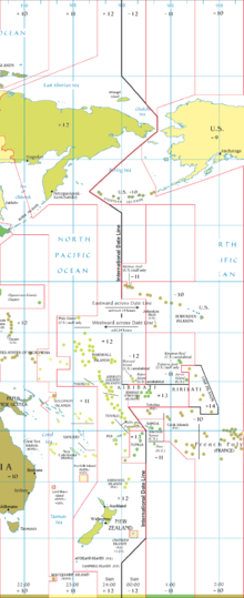 The International Date Line around 180°
The International Date Line (IDL) is a generally north-south imaginary line on the surface of the Earth, passing through the middle of the Pacific Ocean, that designates the place where each calendar day begins. It is roughly along 180° longitude, opposite the Prime Meridian, but it is drawn with diversions to pass around some territories and island groups.
Crossing the IDL travelling east results in a day or 24 hours being subtracted, so that the traveller repeats the date to the west of the line. Crossing west results in a day being added, that is, the date is the eastern side date plus one calendar day. The line is necessary in order to have a fixed, albeit arbitrary, boundary on the globe where the calendar date advances.
Contents
Geography
 Photo taken onboard an aircraft crossing the International Date Line between Alaska and Russia
For part of its length, the International Date Line follows the meridian of 180° longitude, roughly down the middle of the Pacific Ocean. To avoid crossing nations internally the line deviates to pass around the far east of Russia and various island groups in the Pacific.
In the north, the date line swings to the east of Wrangel island and the Chukchi Peninsula and through the Bering Strait passing between the Diomede Islands at a distance of 1.5 km (1 mi) from each island. It then goes southwest, passing west of St. Lawrence Island and St. Matthew Island, until it passes midway between the United States' Aleutian Islands and Russia's Commander Islands before returning southeast to 180°. This keeps Russia which is north and west of the Bering Sea and the United States' Alaska which is east and south of the Bering Sea, on opposite sides of the line in agreement with the date in the rest of those countries.
Two uninhabited atolls, Howland Island and Baker Island, just north of the equator in the central Pacific Ocean, have the latest time on Earth of UTC−12:00 hours, along with ships at sea between 172.5°W and 180°. The date line then circumscribes the country of Kiribati by swinging far to the east, almost reaching the 150° meridian. Kiribati's easternmost islands, the southern Line Islands south of Hawaii, have the most advanced time on Earth of UTC+14 hours. In the South Pacific, the date line also lies east of 180°, so that Wallis and Futuna, Fiji, Tonga, and New Zealand's Kermadec Islands and Chatham Islands have the same date, but American Samoa and New Zealand's Cook Islands are one day earlier. As of 31 December 2011 the date line will be east of both Tokelau[1] and Samoa[2] (but west of American Samoa).
If one flies round the world from east to west (the same direction as Magellan), one hour is lost for every 15° of longitude crossed, losing 24 hours for one circuit of the globe; one compensates by adding 24 hours when crossing the International Date Line (also from east to west). The International Date Line must therefore be observed in conjunction with the Earth's time zones: on crossing it, in either direction, the calendar date is adjusted by one day.
For two hours every day, between 10:00 and 11:59 (UTC), there are actually three different days observed at the same time in different places. At UTC time Thursday 10:15, for example, it is Wednesday 23:15 in American Samoa, which is eleven hours behind UTC, and it is Friday 00:15 in Kiritimati (separated from American Samoa by the IDL), which is 14 hours ahead of UTC. For the first hour (UTC 10:00–10:59), this is true for inhabited territories, whereas during the second hour (UTC 11:00–11:59) it is only true if one counts an uninhabited maritime time zone twelve hours behind UTC.
De facto and de jure date lines
 A simplified illustration of the relation between date line, date and time of day.
All nations unilaterally determine their standard time zones, which are applicable only on land and adjacent territorial waters. These national zones do not extend into international waters. No international organization nor any treaty between nations has fixed the straight line segments and their junctions. Indeed, the 1884 International Meridian Conference explicitly refused to propose or agree to any time zones, stating that they were outside its purview. The conference resolved that the Universal Day (midnight-to-midnight Greenwich Mean Time), which it did agree to, "shall not interfere with the use of local or standard time where desirable". From this comes the utility and importance of UTC, or "Zulu" time: it permits a single and universal reference for time that is valid for all points on the globe at the same moment.
The nautical date line[3] is a de jure construction determined by international agreement. It is the result of the 1917 Anglo-French Conference on Time-keeping at Sea, which recommended that all ships, both military and civilian, adopt hourly standard time zones on the high seas. The United States, for example, adopted its recommendation for U.S. military and merchant marine ships in 1920. This date line is implied but not explicitly drawn on time zone maps. It follows the 180° meridian except where it is interrupted by territorial waters adjacent to land, forming gaps—it is a pole-to-pole dashed line. Ships should adopt the standard time of a country if they are within its territorial waters, but should revert to international time zones (15° wide pole-to-pole gores) as soon as they leave its territorial waters. In reality they use these time zones only for purposes such as radio communication. For internal ship's purposes, e.g. for work and meal hours, passenger events and opening hours they use a time zone of their own choosing. The 15° gore that is offset from UTC by twelve hours is bisected by the nautical date line into two 7.5° gores that differ from UTC by ±12 hours.
Since the nautical date line has not been adjusted for the Kiribati time zone change[3], it is possible to say that the eastern Kiribati islands form enclaves of Asian date in the sea that has American date.
The IDL drawn on the map on this page and all other maps is now and always has been an artificial construct of cartographers—the precise course of the line in international waters is arbitrary. The same is valid in Antarctica. The bases have determined their time, but they are so sparse around the IDL so its course is not determined. The IDL does not end at South pole, since there is a base there with a specified time (New Zealand time).
Historical alterations
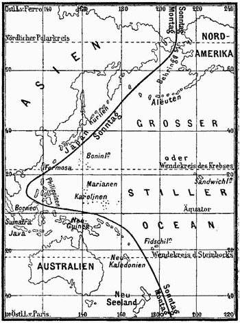
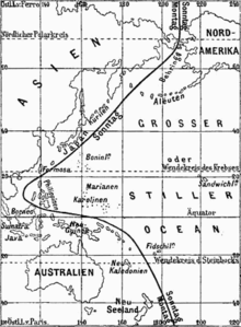 Erroneous International Date Line from an 1888 encyclopedia. Philippines are shown pre-1845, while Alaska is shown post-1867.
The Philippines, as part of the Viceroyalty of New Spain, long had its most important communication with Acapulco in Mexico, and was accordingly placed on the east side of the date line, despite being at the western edge of the Pacific Ocean. 00:01 Tuesday in London was 17:21 Monday in Acapulco and about 08:05 Monday in Manila. During the 1840s, trade interests turned to China, the Dutch East Indies and adjacent areas, and the Philippines was changed to the west side of the date line. Monday, 30 December 1844 (ending up as a 365-day year, despite being a leap year) was followed by Wednesday, 1 January 1845.[4]
Until 1867, Alaska began Russia's day, with the date line following the partially defined border between Russian Alaska and British North America, including the colony of British Columbia. The day before the purchase by the United States took effect, it was Friday, 6 October 1867, in the Julian calendar (used by Russia at the time), which would have been 18 October in the Gregorian calendar. The time in New Archangel would have been 12:00 when it was 12:02, Thursday, 17 October, at the future site of Whitehorse, Yukon, and 12:49, 17 October, at the future site of Vancouver, British Columbia. With the transfer of governance, the date line was shifted (moving Alaska back a day), and the calendar was changed (moving Alaska ahead 12 days), and being effective at midnight the calendar moved ahead one day as well, for a net change of 12 days. Friday, 6 October, was followed by Friday, 18 October (not Saturday, 7 October).
The Samoan Islands were west of the date line until 1892, when King Malietoa Laupepa was persuaded by American traders to adopt the American date, being three hours behind California, to replace the former Asian date, being four hours ahead of Japan. The change was made by repeating Monday 4 July 1892, American Independence Day. At the end of 2011, independent Samoa and Tokelau will shift back west of the date line by skipping Friday 30 December 2011.[2][5][1] American Samoa will remain east of the date line.
The central Pacific Republic of Kiribati introduced a change of date for its eastern half on 1 January 1995, from time zones −11 and −10 to +13 and +14. Before this, the country was divided by the date line. After the change, the date line in effect moved eastwards to go around this country. As a British colony, Kiribati was centered in the Gilbert Islands, just west of the old date line. Upon independence in 1979, the new republic acquired the Phoenix and Line Islands from the United States and the country found itself straddling the date line. Government offices on opposite sides of the line could only communicate by radio or telephone on the four days of the week which were weekdays on both sides. As a consequence, Kiribati's easternmost territory, the Line Islands, including the inhabited Kiritimati island, started the year 2000 before any other country on Earth, a feature the Kiribati government capitalized upon as a potential tourist draw. But it has been noted that the international community has not taken this date line adjustment very seriously, noticing that most world atlases still ignore the Kiribati dateline shift and continue to represent the International Date as a straight line in the Kiribati area.[6]
Cultural references
The date line is a central factor in Umberto Eco's book The Island of the Day Before, in which the protagonist finds himself on a becalmed ship, with an island close at hand on the other side of the International Date Line. Unable to swim, the protagonist's writings indulge in increasingly confused speculation of the physical, metaphysical and religious import of the date line.
Date lines according to religious principles
Judaism
The concept of an international date line is first mentioned in a 12th-century Talmudic commentary[7][8] which seems to indicate that the day changes in an area where the time is six hours ahead of Jerusalem (90 degrees east of Jerusalem, a line running through the Philippines). This line, which he refers to as the K'tzai Hamizrach (the easternmost line), is used to calculate the day of Rosh Hashanah, the Jewish New Year. According to some sources it is alluded to in the Talmud (Rosh Hashanah and Eruvin) as well as in the Jerusalem Talmud.
The date line poses a problem for religious travellers relative to the day on which to observe the Shabbat and Holidays. The Shabbat is on the seventh day of the week, which is constant if one stays on the same side of the date line. The problem occurs when a Jewish traveller crosses the line and for whom it is Friday but for the city the traveller is visiting, it is Saturday. There are several different opinions regarding where exactly the date line is according to Jewish law.[8][9]
The halachic ruling of Rabbi Moshe Heinemann Rabbinic Administrator of the Star-K, is as follows: In New Zealand and Japan, the local Saturday is according to the majority opinion Shabbat, and it should therefore be fully observed as Shabbat, with Shabbat Prayers, etc. However, since according to the Chazon Ish, Shabbat is on the local Sunday, one should not perform any Shabbat Torah prohibitions on Sunday. Nevertheless, on Sunday, one should pray the regular weekday prayers, donning tefillin during morning prayers.[8]
In Hawaii, Saturday is Shabbat according to the majority opinion. Therefore, the local Saturday is fully observed as Shabbat. The day known locally as Friday is Shabbat according to the minority opinion, and one should not perform Shabbat Torah prohibitions on that day. Cooking for Shabbat should therefore be done on Thursday.[8]
Determining the majority opinion on the Aleutian Islands or South Pacific Islands, including Fiji and American Samoa, is complicated and beyond the scope of this article. However, in the following locations, Shabbat is observed on the local Saturday, and a second day is not necessary: Australia, China, Mainland Russia, Taiwan, Hong Kong, Mainland Alaska and Manila, and other areas of the Philippines west of 125.2°E.[8]
Christianity
In Christianity it is also important to hold services on the correct day. Generally, the Christian calendar follows the legal calendar, and the Christian date line is on the same place as the international date line. One important issue exists in the Orthodox countries, where the Julian calendar is followed for religious purposes but the Gregorian calendar for civilian purposes. The two calendars have the same weekdays, so the main issue is when to celebrate Easter, Christmas and other main holidays. In Tonga, the Seventh Day Adventists (who usually observe the sabbath on a Saturday) observe the sabbath on a Sunday, officially due to an anomaly in the International Date Line which makes Sunday really Saturday.
References
- ^ a b Tokelau to follow Samoa on dateline switch Radio New Zealand International. Accessed 15 October 2011.
- ^ a b Tamara McLean, Samoa's dateline jump passes into law Herald Sun of New Zealand. Accessed 11 August 2011.
- ^ A History of the International Date Line
- ^ Samoa confirms dateline switch Borneo Post online. Accessed 11 August 2011.
- ^ Ariel, Avraham; Berger, Nora Ariel (2005). Plotting the Globe: Stories of Meridians, Parallels, and the International Date Line. Greenwood Press. pp. 149. ISBN 0275988953. http://books.google.com/books?id=2xTJt3b3SHUC&pg=PP1#PRA1-PA149,M1.
- ^ Rabbeinu Zecharya Halevi, Baal Hameor, Tractate Rosh Hashana, 20b
- ^ a b c d e A Traveller's Guide To The International Dateline
- ^ Halachic Opinions on the International Dateline world map, 12.06 MB
Time measurement and standards Major subjects International standards UTC · UTC offset · UT · ΔT · DUT1 · IERS · ISO 31-1 · ISO 8601 · TAI · 12-hour clock · 24-hour clock · Barycentric Coordinate Time · Civil time · Daylight saving time · Geocentric Coordinate Time · International Date Line · Leap second · Solar time · Terrestrial Time · Time zoneObsolete standards Time in physics Horology Calendar Astronomical · Dominical letter · Epact · Equinox · Gregorian · Hebrew · Intercalation · Islamic · Julian · Leap year · Lunar · Lunisolar · Seven-day week · Solar · Solstice · Tropical year · Weekday determination · Weekday namesArchaeology & geology Astronomical chronology Units of time Related topics Categories:- Bering Sea
- Chukchi Sea
- Lines of longitude
- Pacific Ocean
- Time measurement standardization


Wikimedia Foundation. 2010.