- Canton of Glarus
-
Kanton Glarus — Canton of Switzerland — 
Coat of arms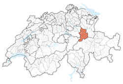
Coordinates: 46°59′N 9°4′E / 46.983°N 9.067°ECoordinates: 46°59′N 9°4′E / 46.983°N 9.067°E Capital Glarus Largest City Glarus Nord Subdivisions 3 municipalities Government - Executive Regierungsrat (7) - Legislative Landsgemeinde (Landrat (80) Area[1] - Total 685.3 km2 (264.6 sq mi) Population (12/2009)[2] - Total 38,479 - Density 56.1/km2 (145.4/sq mi) Highest point 3,614 m (11,857 ft) - Tödi Lowest point 410 m (1,345 ft) - Linth channel at border to St.Gallen Joined 1352 Abbreviation GL Languages German Website GL.ch Map of Glarus
The Canton of Glarus (German pronunciation: [ˈɡlarʊs] (
 listen)) is a canton in east central Switzerland. The capital is Glarus. The population speaks a variety of Alemannic German. The majority of the population (81%) identifies as Christian, about evenly split between the Protestant and Catholic confessions.
Contents
History
 Cantonal museum in the Freulerpalast (Näfels)
According to legend, the inhabitants of the Linth Valley were converted to Christianity in the 6th century by the Irish monk Saint Fridolin, the founder of Säckingen Abbey (d. 538). The Alemanni began to settle in the valley from the early 8th century. The Alemannic German language took hold only gradually, and was dominant by the 11th century. From the 9th century, the area around Glarus was owned by the Säckingen Abbey, town of Glarus being recorded as Clarona. By 1288 the Habsburgs claimed all the abbey's rights.
Glarus joined the Old Swiss Confederacy in 1352 as one of the foundational eight cantons (Acht Orte) of the period of 1353–1481. The first recorded Landsgemeinde of Glarus took place in 1387. Habsburgian attempts to reconquer the valley are repelled in the Battle of Näfels of 1388. A banner depicting Saint Fridolin was used to rally the people of Glarus in that battle, and from that time Glarus has used the image of Saint Fridolin on its flags and in its coat of arms.
The county of Werdenberg was annexed to Glarus in 1517. Between 1506 and 1516 the later reformer Huldrych Zwingli was priest in Glarus, but Glarus remained Catholic, and by 1564 all of Zwingli's followers were eliminated. This, however, did not end the struggles between the Protestants and the Catholics in the area. To secure peace it was decided that each party should have its own assembly (Landsgemeinde) in 1623, and at a later stage in 1683, each side was granted the right to have its own tribunals.
Between 1798 and 1803 Glarus was part of the Canton of Linth as established by Napoleon. In 1836 the constitution was adapted to unite the assemblies and establish a single Landsgemeinde.
On May 6, 2007 Glarus became the first Swiss canton to lower the voting age to 16.[3]
Geography
Further information: Glarus Alps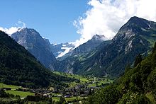
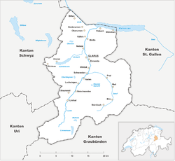
The canton of Glarus is dominated by the deep valley of the Linth River and the smaller Sernftal on the east. Most of the area is mountainous. The highest peak in the Glarus Alps is the Tödi at 3,614 meters (11,857 ft) Other mountains include the Hausstock (3,158 meters (10,361 ft)) and the Glärnisch (2,910 meters (9,550 ft)). The canton contains part of a thrust fault that was declared a geologic UNESCO world heritage site, under the name Swiss Tectonic Arena Sardona, in 2008. Famous outcrops in ths Swiss Tectonic Arena Sardona include those at Lochsite near Glarus and in a mountain cliff called Tschingelhörner between Elm and Flims (in the same cliff is a natural hole called the Martinsloch). There is also a large lake called Walensee (Lake Walen) on the north. The total area of the canton of Glarus is 685 square kilometers (264 sq mi), of which about half is considered productive. Forestry is an important branch of industry in the canton.
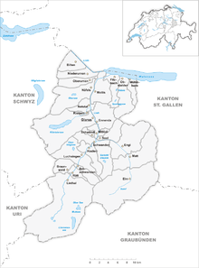
Municipalities
With the Landsgemeinde (cantonal assembly) of 2006, it was decided that the 25 municipalities of Glarus be reduced to only three: Glarus Nord, Glarus and Glarus Süd. The reform has taken effect on 1 January 2011.
The following are the 25 municipalities as they stood until 31 December 2010:
 Municipalities before the reform (2007)
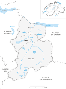 Municipalities after the reform (2011)
Demographics
The population of the canton (as of 31 December 2009) is 38,479.[2] As of 2007[update], the population included 7,314 foreigners (or 19.13% of the total population).[4]
The population (as of 2000[update]) is nearly evenly split between Protestants (44%) and Roman Catholics (37%).[5]
83.6% is German-speaking and 6.8% is Italian-speaking.
Economy
 Electrical power from Klöntalersee is one of the cantons main export services.
The geography of the canton helped to establish slate works in the 17th century. The mountainous surroundings of Glarus were also an advantage in industrialisation. Cotton spinning was important in the 18th century, complementing traditional woolen spinning. Industrialisation also brought cotton printing, hydroelectric plants and later metal and machinery factories, as well as paper mills.
Dairy farming and cattle breeding were not replaced by industrial advances. Cattle graze on mountain pastures. Cattle breeding and dairying are important on the mountain pastures.
References
- ^ Arealstatistik Standard - Kantonsdaten nach 4 Hauptbereichen
- ^ a b Swiss Federal Statistical Office (German) accessed 4 April 2011. Numbers are from December 2009 but cover the new municipal borders from 2011.
- ^ SwissInfo, retrieved on May 7, 2007
- ^ Federal Department of Statistics (2008). "Ständige Wohnbevölkerung nach Staatsangehörigkeit, Geschlecht und Kantonen" (Microsoft Excel). http://www.bfs.admin.ch/bfs/portal/de/index/themen/01/02/blank/key/raeumliche_verteilung/kantone__gemeinden.html. Retrieved November 5, 2008.
- ^ Federal Department of Statistics (2004). "Wohnbevölkerung nach Religion" (Interactive Map). http://www.bfs.admin.ch/bfs/portal/de/index/themen/01/05/blank/key/religionen.html. Retrieved 2009-01-15.
External links
- Official Statistics
- Official Site (German)
Three Cantons · Eight Cantons · Thirteen Cantons · coats of arms historical cantons: Unterwalden ·
  Basel ·
  Appenzell · Baden · Bellinzona · Fricktal · Léman · Linth · Lugano · Oberland · Raetia · Säntis · WaldstättenCategories:
- Canton of Glarus
- Cantons of Switzerland
- Imperial valleys


Wikimedia Foundation. 2010.