- Millthorpe, New South Wales
-
Millthorpe
New South Wales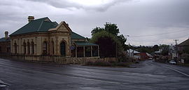
Main Street of Millthorpe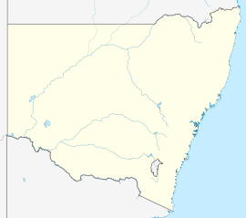
 Millthorpe
Population: 725 (2006 Census)[1] Postcode: 2798 Elevation: 960.0 m (3,150 ft) Location: LGA: Blayney State District: Orange Federal Division: Calare Mean max temp Mean min temp Annual rainfall 17.7 °C
64 °F6.3 °C
43 °F802.1 mm
31.6 inMillthorpe is a town located between Orange and Blayney in New South Wales, Australia in the Blayney Shire. At the 2006 census, Millthorpe had a population of 725 people.[1] The town was once a major potato growing area and continues to have extensive agricultural activities. The town was originally called Spring Grove.
Millthorpe is a picturesque, compact and historic village set amidst gently rolling hills. Classified by the National Trust, it has a number of fine historic buildings, as well as cobbled, bluestone-bordered streets, art galleries, gift and antiques shops, a museum, two hotels, restaurants and cafes, a bowling club and motel. Two of the main streets, Victoria (which runs east-west) and Park (north-south), follow the contours of the local topography with a more regularised grid system extending outwards from them. Millthorpe is located 252 km north-west of Sydney and 22 km south of Orange.
European settlement of the area began when a government stock station was established in 1823. The town is based upon a land grant originally known as 'Grove Farm' which was made out to convict overseer Charles Booth in 1834. Noted explorer Thomas Mitchell twice stayed there during inland expeditions.
The area developed as a farming centre from 1840 to 1880 with orchards established in the 1860s. Local agriculture received a considerable boost from the arrival of the railway in the 1870s. A large flour mill was established in 1882. Consequently, in 1884 the town's name was changed from Spring Grove to Millthorpe. Today it is still essentially a service centre to the rich farmlands which surround it.
Millthorpe's commercial area was extended after the depression of the 1890s and many of its largely brick buildings date from that period. The town's decline after World War I means that it was spared redevelopment and so many of its buildings have survived with very little alteration.
-

Commercial Hotel
-

Post Office
-

Public School
Notes and references
- ^ a b Australian Bureau of Statistics (25 October 2007). "Millthorpe (L) (Urban Centre/Locality)". 2006 Census QuickStats. http://www.censusdata.abs.gov.au/ABSNavigation/prenav/LocationSearch?collection=Census&period=2006&areacode=UCL153000&producttype=QuickStats&breadcrumb=PL&action=401. Retrieved 30 October 2009.
External links
Towns, suburbs and localities of Blayney Shire | Central West | New South Wales Categories:- Towns in New South Wales
- Towns in the Central West, New South Wales
-


Wikimedia Foundation. 2010.