- New York metropolitan area
-
New York Metropolitan Area
New York-Newark-Bridgeport
New York-New
Jersey-Connecticut-Pennsylvania
Combined Statistical Area (CSA)— Tri-State Area — New York Newark
 Bridgeport
Coordinates: 40°48′31″N 74°1′13.39″W / 40.80861°N 74.0203861°WCoordinates: 40°48′31″N 74°1′13.39″W / 40.80861°N 74.0203861°W Country United States of America States  New York,
  New Jersey,
  Connecticut,
  Pennsylvania
Largest city New York City Other Cities Newark
Jersey City
Yonkers
Paterson
Bridgeport
Elizabeth
Stamford
New Haven
Waterbury
Clifton
Norwalk
Danbury
New Rochelle
PassaicArea – Total 11,842 sq mi (30,670.6 km2) Elevation 509-0 ft (509 m) Population (2010) – Total 22,085,649 – Density 1,865/sq mi (720.1/km2) Ranked 1st in the US Time zone EST (UTC-5) – Summer (DST) EDT (UTC-4) Area code(s) 212, 646 917, 718, 347, 917, 929, 516, 631, 914, 845, 570, 203, 201, 551, 862, 973  Map of the Metropolitan Area
The New York metropolitan area, also known as Greater New York, or the Tri-State area, is the region that composes of New York City and the surrounding region. It is the most populous metropolitan area in the United States (including both the Metropolitan Statistical Area definition and the Combined Statistical Area definition) and is also one of the most populous in the world. It includes the largest city in the United States (New York City), the five largest cities in New Jersey (Newark, Jersey City, Elizabeth, Paterson and Trenton) and six of the seven largest cities in Connecticut (Bridgeport, New Haven, Stamford, Waterbury, Norwalk & Danbury). The total area of the metropolitan area is 11,842 sq mi (30,671 km2). It is one of the most important regions in the United States and the world being a center of industries such as entertainment, finance, news media, and manufacturing.
Contents
Definitions
Metropolitan Statistical Area
 New York-Northern New Jersey-Long Island, NY-NJ-PA Metropolitan Statistical Area
New York-White Plains-Wayne, NY-NJ Metropolitan Division
Nassau-Suffolk, NY Metropolitan Division
Newark-Union, NJ-PA Metropolitan Division
Edison-New Brunswick, NJ Metropolitan Division
Rest of the New York-Newark-Bridgeport, NY-NJ-CT-PA Combined Statistical AreaThe U.S. Office of Management and Budget has two definitions of the area: the Metropolitan Statistical Area (MSA) and the Combined Statistical Area (CSA). The MSA definition is called the New York-Northern New Jersey-Long Island, New York-New Jersey-Pennsylvania Metropolitan Statistical Area, and includes a population of 18,897,109 as of the 2010 census.[1] (roughly 1 in 16 Americans) as of 2010. The MSA is further subdivided into four metropolitan divisions. The 23-county metropolitan area includes ten counties in New York State (those coinciding with the five boroughs of New York City, the two counties of Long Island, and three counties in the lower Hudson Valley); 12 counties in Northern and Central New Jersey; and one county in northeastern Pennsylvania. The largest urbanized area in the United States is at the heart of the metropolitan area, the New York–Newark, NY–NJ–CT Urbanized Area (estimated to have a population of 18,319,939 as of 2008 and an area of 6,720 square miles).
The counties and county groupings constituting the New York metropolitan area are listed below with 2009 U.S. Census Bureau estimates of their populations.
New York-Northern New Jersey-Long Island, NY-NJ-PA Metropolitan Statistical Area (19,069,796)
- New York-White Plains-Wayne, NY-NJ Metropolitan Division (11,732,233)
- Kings County (Brooklyn), NY
- Queens County, NY
- New York County (Manhattan), NY
- Bronx County, NY
- Richmond County (Staten Island), NY
- Westchester County, NY
- Bergen County, NJ
- Hudson County, NJ
- Passaic County, NJ
- Rockland County, NY
- Putnam County, NY
- Nassau-Suffolk, NY Metropolitan Division (2,875,904)
- Edison-New Brunswick, NJ Metropolitan Division (2,335,390)
- Newark-Union, NJ-PA Metropolitan Division (2,126,269)
Combined Statistical Area
The Combined Statistical Area definition consists of the original MSA plus a wider region consisting of five adjacent metropolitan areas. The area is known as the New York-Newark-Bridgeport, New York-New Jersey-Connecticut-Pennsylvania Combined Statistical Area, with an estimated population of 22,085,649[2] as of 2009. About one out of every fifteen Americans resides in this region, which includes seven additional counties in New York, New Jersey, and Connecticut, and is often referred to as the Tri-state Area and less commonly the Tri-State Region (but leaving out Pennsylvania). However, the New York City television designated market area (DMA) includes Pike County, Pennsylvania[3], which is also included in the CSA.
This wider region includes the largest city in the United States (New York City), the five largest cities in New Jersey (Newark, Jersey City, Elizabeth, Paterson and Trenton) and six of the seven largest cities in Connecticut (Bridgeport, New Haven, Stamford, Waterbury, Norwalk & Danbury). The total land area of the extended metropolitan area is 11,842 sq mi (30,671 km2).
In addition to the New York-Northern New Jersey-Long Island, NY-NJ-PA Metropolitan Statistical Area, the following Metropolitan Statistical Areas are also included in the New York-Newark-Bridgeport, NY-NJ-CT-PA Combined Statistical Area (total pop. 22,232,494):
- Bridgeport-Stamford-Norwalk,Connecticut Metropolitan Statistical Area (916,829)
- New Haven-Milford, CT Metropolitan Statistical Area (862,477)
- Poughkeepsie-Newburgh-Middletown, NY Metropolitan Statistical Area (677,094)
- Trenton-Ewing, NJ Metropolitan Statistical Area (366,222)
- Torrington, CT Micropolitan Statistical Area (189,927)
- Kingston, NY Metropolitan Statistical Area (182,693)
- Ulster County (182,693)
Geography
The area is frequently divided into the following regions:[4][5]
- New York City (Center of the region)
- Long Island (Nassau & Suffolk Counties, NY – separated by water from the rest of the region except New York City; not including Queens County or Kings County (Brooklyn) , which coincide with two of New York City's Five Boroughs)
- North Jersey-Northern portion of New Jersey
- Central Jersey- Middle portion of New Jersey
- Hudson Valley (Lower Hudson Valley suburbs of Westchester, Putnam and Rockland Counties; and Mid-Hudson exurbs of Dutchess, Orange and Ulster Counties)
- Western Connecticut (Only Fairfield, New Haven and Litchfield Counties are part of the region and separated by the state line)
All five areas can be (and often are) further divided. For instance, Long Island can be divided into the South and North Shores (usually when speaking about Nassau County), Western Suffolk, and the East End. The Hudson Valley and Connecticut are sometimes grouped together and referred to as the Northern Suburbs, largely because of the shared usage of Metro-North Railroad.[6]
Subregions
 Long Island/NYC
New York City
Further information: New York CityLong Island
Long Island is home to two of New York City's boroughs:Brooklyn and Queens as well as the more suburban Nassau and Suffolk counties.
It has a population of 7,568,304 as of the United States Census 2010 and is the most populated island in the United States and the 17th most populous island in the world. For transportation, it is served by the Long Island Expressway and the Long Island Railroad, both of which are heavily used for transport. It is also home to John F. Kennedy International Airport and LaGuardia Airport, two of the three major airport hubs in the area.
Northern New Jersey
Northern New Jersey is typically defined as the following counties:
- Bergen County
- Essex County
- Hudson County
- Middlesex County
- Hunterdon County (anything north of Readington Township)
- Morris County
- Passaic County
- Somerset County (anything north of Watchung)
- Sussex County
- Union County (anything north of Westfield)
- Warren County
The New Jersey State Department of Tourism splits North Jersey into the urban Gateway Region and the more rural Skylands Region in regards to their contrasting character and quality.
Northern New Jersey is home to six of the largest cities of New Jersey:Newark, Jersey City, Paterson, Elizabeth, Woodbridge Township, and Edison. The region can be geographically diverse with wetlands, mountains, and valleys scattered throughout the area. It has a large network of expressways and public transportation rail services which are mostly operated by New Jersey Transit. It is also home to the second largest airport in the area, Newark Liberty International Airport.
Central Jersey

Central Jersey is the middle portion of the state. It is home to both New York and Philadelphia commuters. Due to this fact it is loosely associated with the Delaware Valley and is considered to be part of both regions. Important towns such as Trenton (State capital of New Jersey) and Princeton (home to Ivy League Princeton University) are located in this subregion.
Hudson Valley
The Hudson Valley is the valley centered around the Hudson River north of New York City. It is mostly suburban and contains less job centers in contrast to the rest of the region. and Long Island. It is one the fastest growing areas as a result of the high housing costs in New York City and the inner suburbs. Historically, the valley was home to many factories, but many have closed. Cleanup efforts to improve the Hudson River water quality after years of pollution are currently planned and will be supervised by the United States Environmental Protection Agency (EPA).[7]
Connecticut
Further information: Fairfield County, Connecticut, New Haven County, Connecticut, and Litchfield County, ConnecticutFairfield, New Haven, and Litchfield Counties are located in the western portion of Connecticut with large business and industrial parks scattered throughout the area although mostly contained within Fairfield County. The three counties (and Connecticut in general) have had a long-standing reputation for affluence. Geographically, the areas are flat along the coast with low hills eventually giving way to large mountain ranges such as The Berkshires further inland. Many of the largest cities in the state are located within New Haven and Fairfield Counties.
Urban areas of the region


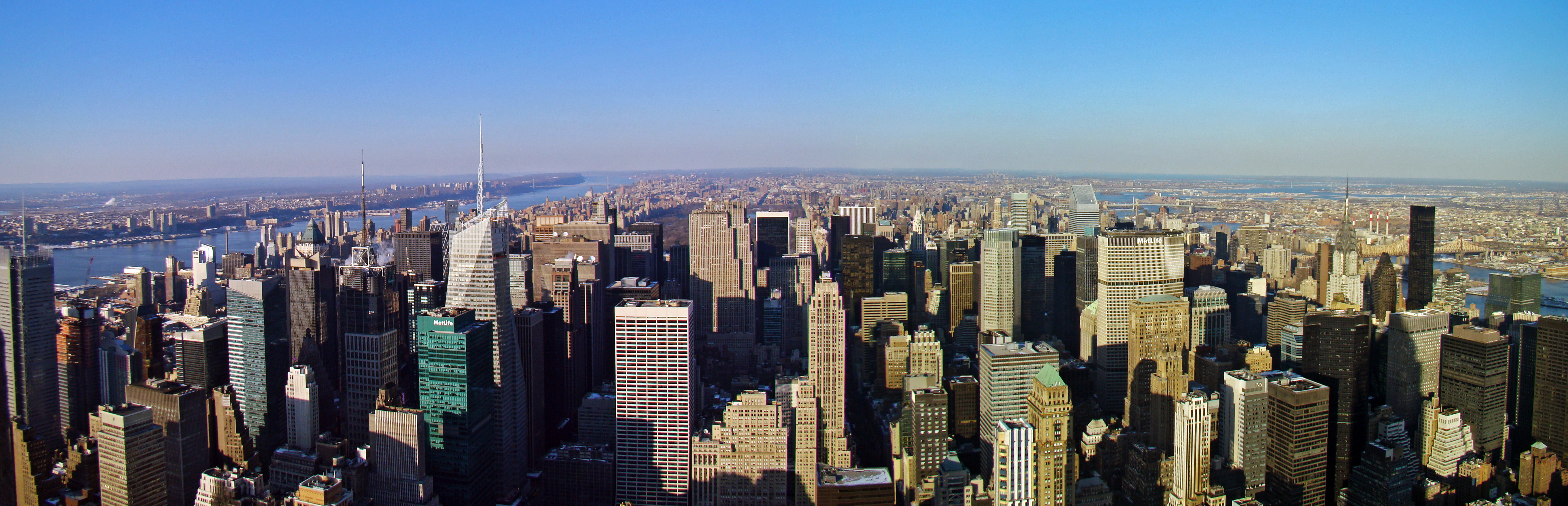
Skyline of New York City and Jersey City from Newark, New Jersey The combined statistical area is a multicore metropolitan region containing several urban areas.
Population
RankUrbanized Area State(s) 2000
Population1 New York—Newark NY--NJ--CT 17,799,861 42 Bridgeport—Stamford CT--NY 888,890 70 New Haven CT 531,314 90 Poughkeepsie—Newburgh NY 351,982 122 Trenton NJ 268,472 163 Waterbury CT 189,026 190 Danbury CT--NY 154,455 350 Hightstown NJ 69,977 435 Kingston NY 53,458 452 Middletown NY 50,071 Principal cities
The following is a list of principal cities in the New York-Newark-Bridgeport Combined Statistical Area with 2005 U.S. Census Bureau estimates of their population. Principal cities are generally those where there is a greater number of jobs than employed residents.[8][9]
- New York-Northern New Jersey-Long Island MSA
- New York City (8,143,197)
- Newark, New Jersey (280,666)
- Jersey City, New Jersey (247,597)
- Yonkers, New York (195,976)
- Paterson, New Jersey (146,199)
- Edison, New Jersey (100,499)
- New Rochelle, New York (73,260)
- Mount Vernon, New York (67,292)
- White Plains, New York (56,733)
- Union, New Jersey (55,326)
- Wayne, New Jersey (55,150)
- Hempstead (village), New York (53,891)
- New Brunswick, New Jersey (50,143)
- Hoboken, New Jersey (50,005)
- Hackensack, New Jersey (43,010)
- Long Beach, New York (33,275)
- Trenton-Ewing MSA
- Trenton, New Jersey (84,639)
- Ewing, New Jersey (37,237)
- Bridgeport-Stamford-Norwalk MSA
- Bridgeport, Connecticut (139,008)
- Stamford, Connecticut (120,045)
- Norwalk, Connecticut (84,437)
- Danbury, Connecticut (78,736)
- Stratford, Connecticut (49,943)
- New Haven-Milford MSA
- New Haven, Connecticut (124,791)
- Milford, Connecticut (53,045)
- Poughkeepsie-Newburgh-Middletown MSA
- Poughkeepsie, New York (30,355)
- Newburgh, New York (28,548)
- Middletown, New York (26,067)
- Kingston MSA
- Kingston, New York (23,067)
- Torrington Micropolitan Area
- Torrington, Connecticut (35,995)
Economy
Main article: Economy of New York City The New York Stock Exchange is the largest stock exchange by market capitalization.
The regional economy is the largest in the United States and one of the most important in the world as a center in international banking and commerce. New York is considered a global city. Finance, real estate, manufacturing, tourism, biotechnology, and education are in general, the leading industries in the area. Other industries include entertainment and news media. In 2010, the gross metropolitan product was $1.28 trillion dollars[10], second only to Tokyo and is bigger than all but 14 countries.[11] Along with its wealth, the area has a cost of living that is one of the highest in the world.[12]
Education
The metropolitan area has numerous higher education institutions. Prestigious colleges such as Columbia University New York University, and Yale University (the latter is located outside the New York proper in New Haven) are located in the region.The New York City Department of Education is the largest school district in the United States serving over 1.2 million students.[13] Public high schools such as High Technology High School in Monmouth County, New Jersey, Newcomers High School in Long Island City, and Stuyvesant High School are some of the most prestigious in the country.[14]
Attainment
According to the 2010 American Community Survey, Out of the 14,973,063 over 25 years of age, 14.8% (2,216,578) had a graduate or professional degree, 21.1% (3,166,037) had a bachelor's degree, 6.4% (962,007) had a associate degree, 16.0% (2,393,990) had some college education but no degree, 26.8% (4,009,901) had a high school diploma or equivalent, 14.8% (2,224,557) had less than a high school education.[15] In 2010, CNN Money ranked the area as one of the top 10 smartest regions in the United States. [16]
Transportation
Commuter rail
The metropolitan area is partly defined by the areas from which people commute into New York City . The city is served by three primary commuter rail systems plus Amtrak.
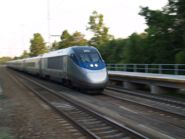
 An Acela Express train going to New York City. The Acela Express is the first and only high-speed rail service in the country.
The Long Island Rail Road (LIRR), the busiest commuter railroad in the United States,[17] is operated by the Metropolitan Transportation Authority (MTA), an agency of New York State. It has two major terminals at Pennsylvania Station in Midtown Manhattan and Atlantic Terminal in Downtown Brooklyn, with a minor terminal at Long Island City station and a major transfer point at Jamaica station in Queens.
Metro-North Railroad (MNRR), the second busiest commuter railroad in the United States,[17] is also operated by the MTA, but in conjunction with the Connecticut Department of Transportation and New Jersey Transit. Its major terminal is Grand Central Terminal. Trains on the Port Jervis Line and Pascack Valley Line terminate at Hoboken Terminal; commuters may transfer at either Secaucus Junction for New Jersey Transit trains to New York Pennsylvania Station or at Hoboken Terminal for PATH trains into Manhattan.
New Jersey Transit (NJT), the third busiest commuter railroad in the United States by passenger miles and also third in trips when direct operated and purchased transportation services are both included (fourth if only direct operated are included),[17] is operated by the New Jersey Transit Corporation, an agency of New Jersey, in conjunction with Metro-North and Amtrak. A map of the system can be found here. It has major terminals at Pennsylvania Station in Manhattan, Hoboken Terminal in Hoboken, and Pennsylvania Station in Newark, with a major transfer point at Secaucus Junction. New Jersey transit also operates a light rail system in Hudson County, as well as the Newark City Subway. NJ Transit also consists of commuter buses operating in and out of Manhattan.
Amtrak's Northeast Corridor offers service to Philadelphia, New Haven, and other points between and including Boston and Washington, D.C.
Major stations in the metropolitan area are:
Station Railroad(s) County Type Pennsylvania Station (New York City) LIRR, NJT, Amtrak New York Terminal and Transfer Grand Central Terminal MNRR New York Terminal Pennsylvania Station (Newark) NJT, Amtrak, PATH Essex Terminal and Transfer Hoboken Terminal NJT, MNRR, PATH Hudson Terminal Atlantic Terminal LIRR Kings Terminal Hunterspoint Avenue LIRR Queens Terminal Jamaica Station LIRR Queens Terminal and Transfer Secaucus Junction NJT, MNRR Hudson Transfer New Haven Union Station MNRR, Amtrak, Connecticut Shore Line East New Haven Terminal and Transfer Trenton Station NJT, Amtrak, SEPTA Mercer Terminal and Transfer The following table shows all train lines operated by these commuter railroads in the New York metropolitan area. New Jersey Transit operates an additional train line in the Philadelphia metropolitan area. (Shown counterclockwise from the Atlantic Ocean):
Additionally, the Port Authority of New York and New Jersey, an agency of the states of New York and New Jersey, operates the PATH system. This heavy rail transportation service serves the counties of New York, Hudson and Essex. A map can be found here.
Major highways
The following highways serve the region
- Interstate 78 (Phillipsburg-Newark Expressway/Holland Tunnel)
- Interstate 80 (Bergen-Passaic Expressway)
- Interstate 84
- Interstate 87 (Major Deegan Expressway)
- Interstate 95 (George Washington Bridge/Trans-Manhattan Expressway/Alexander Hamilton Bridge/Cross Bronx Expressway/Bruckner Expressway/New England Thruway/Connecticut Turnpike)
- Interstate 195 (Central Jersey Expressway)
- Interstate 295 (New York) (Clearview Expressway)
- Interstate 287—serves as beltway around New York City (Middlesex Freeway/Cross-Westchester Expressway)
- Interstate 495 also known as Long Island Expressway or LIE
- Interstate 895 (New York) (Arthur V. Sheridan Expressway)
- Interstate 684
- Interstate 280 (New Jersey)
- Interstate 678 (Van Wyck Expressway/Whitestone Expressway/Hutchinson River Expressway)
- U.S. Route 1 (Trenton Freeway/Trenton–Morrisville Toll Bridge/George Washington Bridge/Pulaski Skyway)
- U.S. Route 9 (Pulaski Skyway/Croton Expressway]]
- New Jersey Route 3 (Secaucus Bypass)
- New Jersey Route 4
- New Jersey Route 17
- New Jersey Route 21
- New Jersey Route 139
- New Jersey Route 495 (Lincoln Tunnel)
- New Jersey Route 24
- New Jersey Route 208
- Garden State Parkway
- New Jersey Turnpike
- Merritt Parkway
- Taconic State Parkway
- Saw Mill River Parkway
- Palisades Interstate Parkway
- Northern State Parkway
- Southern State Parkway
- Hutchinson River Parkway
- Bronx River Parkway
- Prospect Expressway
- JFK Expressway
Commuter bus
New Jersey Transit, Academy Bus, Coach USA, Adirondack Trailways (under the names of New York Trailways, Pine Hill Trailways, as well as Adirondack Trailways) and several other companies operate commuter coaches into the Port Authority Bus Terminal in Manhattan, and many other bus services in New Jersey. Bus services also operate in other nearby counties in the states of New York and Connecticut, but most terminate at a subway terminal or other rail station.
Major airports
 John F. Kennedy airport is the largest airport serving the area
The metropolitan area is served by three major airports.
Airport IATA code ICAO code County State John F. Kennedy International Airport JFK KJFK Queens New York Newark Liberty International Airport EWR KEWR Essex/Union New Jersey LaGuardia Airport LGA KLGA Queens New York The following smaller airports are also in the metro area and provide daily commercial service:
Airport IATA code ICAO code County State Long Island MacArthur Airport ISP KISP Suffolk New York Stewart International Airport SWF KSWF Orange New York Tweed New Haven Regional Airport HVN KHVN New Haven Connecticut Westchester County Airport HPN KHPN Westchester New York Commuter usage
According to the 2010 American Community Survey, 54.3 % (5,476,169) of commuters used a car or other private vehicle alone, 7.0% (708,788) used a carpool, 27.0% (2,721,372) used public transportation, 5.5% (558,434) walked to work, 2.0% (200,448) used some other mean of transportation to work. [18]
See also
History
Main article: History of New York CityDuring the Wisconsinan glaciation, the region was at the edge of a large ice sheet that was over 1000 feet in depth. The ice sheet scraped away large amounts of soil, leaving bedrock. Later on, the ice sheet would help split Long Island and what is now Staten Island apart.
The region was inhabited by Native American tribes such as the Lenape and others. The tribes used the abundant waterways that traversed the area for many purposes such as fishing and trade. Later, when Henry Hudson visited the area, he built a settlement called New Amsterdam in Lower Manhattan Island. New Amsterdam would later become today's New York City. In 1664, the English conquered the Dutch land holdings that included New Amsterdam and renamed it New York for the Duke of York. As the fur trade further moved north, New York became a trade hub. The trading bought in a diverse set of ethnic groups such as Africans, Jews, and the Portugese. The island of Manhattan was in some measure self-selected as a future metropolis by its extraordinary natural harbor formed by New York Bay (actually the drowned lower river valley of the Hudson River, enclosed by glacial moraines), the East River (actually a tidal strait) and the Hudson River, all of which are confluent at the southern tip, from which all later development spread.
During the American Revolution, New York was an important region during the battle, many battles such as the Battle of Long Island and the Battle of New York were fought here. However, New York remained in the hands of the British until the war ended with the United States gaining independence. After the war, New York was made capital of the United States, although for a rather short term before being moved to Philadelphia. In 1792, the Buttonwood Agreement was made by a group of merchants beginning the dawn of the New York Stock Exchange. Today, many people in the Tri-State Area work in this important stock exchange. Large-scale immigraition into New York was a result of large demand for manpower. The Cosmpolitan attitidue created tolerance for various cultures and ethnic groups. German, Irish, and Italian immigraition were some of the largest ethnic groups. Today, many of their descendents continue to live in the region. Cultural buildings such as , the Metropolitan Museum of Art, the Metropolitan Opera, the American Museum of Natural History. New York newspapers were read around the country as media moguls James Gordon Bennett, Sr., Joseph Pulitzer and William Randolph Hearst battle for readership. In 1884, over 70% of exports passed through ports in New York or in one of the surrounding towns. The modern New York City was founded in 1898, with the consolidation of what is now Manhattan, Staten Island, Brooklyn, Queens, and the Bronx.
The now unified New York City encouraged more physical connections between the boroughs and the growth of bedroom communities. The New York City Subway began operating in 1905 although split into different private systems that were later taken over by the city. Railroad stations such as Grand Central Terminal and Pennsylvania Station helped fuel suburban growth. During the era of Prohibition, the time when alcohol was banned, organized crime grew as demand for bootleg alcohol skyrocketed. The iconic Broadway Theater District developed with the showing of the musical, Show Boat.
The Great Depression ended the region's fortunes as a period of widespread unemployment and poverty began. City planner Robert Moses began his automobile centered career of building bridges, parkways, and later expressways. During World War II, the city economy was hurt due to the loss of shipping with Europe by blockades of German U-Boats. However, after the war ended, the city emerged as the only major city in the world unscathed by bombings and warfare.
After its population peaked in 1950, the city began to fall in decline with the population leaving the city for the suburbs. The effects were a result of white flight. Industry and commerce also declined in this era as well, with businesses leaving for the suburbs and other cities. Crime affected the city severely. Urban renewal projects alleviated the decay in Midtown Manhattan to a certain extent but later failed. Blackouts such as the Northeast Blackout of 1965 and the New York City Blackout of 1977 caused massive rioting. A rare highlight was the completion of the World Trade Center, which was one of the tallest buildings in the world. When conservative Ed Koch was elected, he would help rebuild the city and usher in a new era of prosperity.
In the 1980's, the city economy was booming. Wall Street was fueling an economic surge in the real estate market. Despite this, crime was still an issue. In the 1990's crime dropped substanially as the city transformed itself from a decaying city into an world class city.
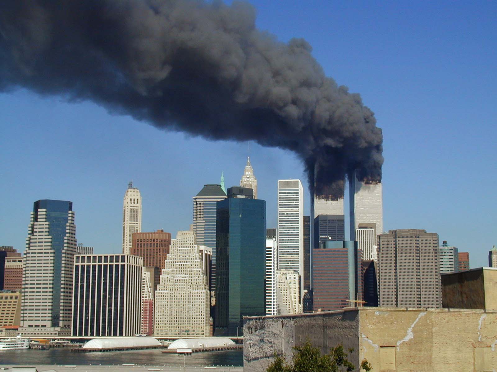
 The World Trade Center burning. It would later collapse, killing over 2,000 people many of whom lived in the suburbs surrounding the city
A major event in the regions history was the September 11th attacks, killing over 2,000 people as two planes crashed into the World Trade Center, later causing them to collapse. Businesses led an exodus from Lower Manhattan because of this. In 2003, another blackout occured, the 2003 North America blackout but suffered no looting. A building boom in New York City cotinues to this day although this has been slowed down by the Great Recession.
Statistical history
The U.S. Census Bureau first designated metropolitan areas in 1950 as standard metropolitan areas (SMAs). The "New York-Northeastern NJ SMA" was defined to include 17 counties: 9 in New York (the five boroughs of New York City, Nassau, Suffolk, Westchester, Rockland) and 8 in New Jersey (Bergen, Hudson, Pasaic, Essex, Union, Morris, Somerset, Middlesex). In 1960, the metropolitan area standards were modified and renamed standard metropolitan statistical areas (SMSAs). The new standards resulted in the splitting of the former SMA into several pieces: the nine New York counties became the "New York SMSA"; three of the New Jersey counties (Essex, Union, Morris) became the "Newark SMSA"; two other New Jersey counties (Bergen, Passaic) became the "Paterson-Passaic-Clifton SMSA"; Hudson County was designated the "Jersey City SMSA"; and Middlesex and Somerset counties lost their metropolitan status. In 1973, a new set of metropolitan area standards resulted in further changes: Nassau and Suffolk counties were split off as their own SMSA ("Nassau-Suffolk SMSA"); Bergen County (originally part of the Paterson-Clifton-Passaic SMSA) was transferred to the New York SMSA; the New York SMSA also received Putnam County (previously non-metropolitan); Somerset County was added to the Newark SMSA; and two new SMSAs, the "New Brunswick-Perth Amboy-Sayreville SMSA" (Middlesex County) and "Long Branch-Asbury Park SMSA" (Monmouth County), were established. In 1983, the concept of a consolidated metropolitan statistical area (CMSA) was first implemented. A CMSA consisted of several primary metropolitan statistical areas (PMSAs), which were individual employment centers within a wider labor market area. The "New York-Northern New Jersey-Long Island CMSA" consisted of 12 PMSAs. Seven PMSAs were based on the original 1950 New York SMA that were split up: New York, Bergen-Passaic, Jersey City, Middlesex-Somerset-Hunterdon (Hunterdon added for the first time), Monmouth-Ocean (Ocean added for the first time), Nassau-Suffolk, and Newark (Sussex added for the first time). One additional PMSA was the Orange County PMSA (previously the Newburgh-Middletown SMSA). The other four PMSAs were former SMSAs in Connecticut: Bridgeport, Stamford, Norwalk, and Danbury. In 1993, four PMSAs were added to the New York-Northern New Jersey-Long Island CMSA: Trenton PMSA (Mercer County), Dutchess County PMSA, Waterbury PMSA, and New Haven PMSA. Several new counties were also added to the CMSA: Sussex, Warren, and Pike. The CMSA model was originally utilized for tabulating data from the 2000 census. In 2003, a new set of standards was established using the core-based statistical area (CBSA) model was adopted and remains in use as of 2010. The CBSA model resulted in the splitting up of the old CMSA into several metropolitan statistical areas: New York-Northern New Jersey-Long Island, Poughkeepsie-Newburgh-Middletown, Trenton-Ewing, Bridgeport-Stamford-Norwalk (includes Danbury), and New Haven-Milford (includes Waterbury).
Demographics
2010 Census
As of the 2010 Census, the metropolitan area had a population of 22,085,649. The Population density was 1,865 per square mile. The racial markup was that 61.6% or 13,595,960 were White,16.9% or 3,727,105 were African Americans, 0.5% or 102,349 were American Indian and Alaskan Native, Asians were 9.1% or 2,008,906 overall, Pacific Islanders were less than 1% with a population of 9,971, 8.8% or 1,944,165 listed themselves as "some other race", while 3.2% (697,193) were of two or more races. Hispanics were 21.7% of any race or 4,790,542.
The median age was 37.9. 25.5% were under 18, 9.5% were 18 to 24 years, 28% were 25 to 44 years of age, 26.6% were 45 to 64 years old, and 13.2% were over the age of 65. Males composed 48.3% of the population while females were 51.7% of the population.
97.7% of the population were in households, 2.3% were in group quarters, and 1% were institutionalized. There were 8,103,731 of which 30.2 or 2,449,343 had children. 46.1% or 3,736,165 were composted of opposite sex and married couples. Male households with no wife composed 4.9% or 400,534. 15.0% or 1,212,436 were female households, with no husbands. 34% or 2,754,596 were non-family households. The household density were 684 per square mile. 91.9% of housing units were occupied with a 3.8% vacancy rate. The average household size was 2.65 per household. The average income for non-family households was $90,335, and the average income for families was $104,715. 13.3% or 2,888,493 of the popluation were below the poverty line.
26.7% or 5,911,993 of the population were born outside the United States. Out of this,17.4% or 1,028,506 were born in Europe, 27.0% or 1,595,523 were born in Asia, 3.8% or 224,109 were born in Africa, 0.2% or 11,957 were born in Oceania, 50.6% or 2,992,639 were born in Latin America.
Diversity
Ethnic diversity
 The Statue of Liberty has become an iconic symbol of immigration
Since its foundation as the mercantile colony of New Netherland the metropolitan area has been noted for ethnic diversity. Beginning in the later 19th century, the New York Area was in large degree divided among Italians, Irish, German, Jewish, African-American and Chinese populations. The Polish and Lebanese also established small communities. Thanks to successive waves of immigration, begun in earnest in the 19th century and continuing today, the area's diversity continues to grow. The states of New York, New Jersey, and Connecticut are all ranked among the top 10 fastest-growing immigration states in America, and great numbers of recent immigrants from across Latin America, East Asia, and the Caribbean now call the New York metropolitan area home. While prominent ethnic neighborhoods in the region are too numerous to list, there are multiple neighborhoods with large German, Jewish, Puerto Rican, Dominican, Cuban, Nicaraguan, Colombian, Jamaican, Haitian, Ecuadorian, Guatemalan, Mexican, Chinese, Guyanese, Trinidadian, Filipino, Russian, Turkish, Arab, Albanian, Korean, Japanese, Indian, Pakistani, Bangladeshi, Italian, Irish, Salvadorian, Peruvian, Greek, and Polish communities. The cuisines of virtually every major ethnic group are at least partially represented in the area, with the culinary landscape of New York changing slightly from year to year as new arrivals settle in.[19]
Religious divserity
The New York metropolitan area hosts a religious diversity in line with its ethnic diversity. Houses of worship exist for numerous Christian denominations, especially Catholicism but also various churches within both Eastern Orthodoxy and Protestantism. New York has a large Jewish population, is a major center of Orthodox Judaism and is home to the headquarters of many Hasidic movements, particularly in the borough of Brooklyn. Hinduism, Islam, Buddhism, Sikhism, Taoism, and many other religions have formal houses of worship in the area. Along with these religions, there are also many people who practice no religion at all.
Culture
Sports teams

Listing of the professional sports teams in the New York metropolitan area
- National Basketball Association (NBA)
- Women's National Basketball Association (WNBA)
- Major League Baseball (MLB)
- New York Mets
- New York Yankees
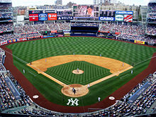 Yankee Stadium is the home of the New York Yankees
- Minor League Baseball (MiLB)
- Atlantic League of Professional Baseball (ALPB)
- Bridgeport Bluefish
- Lakewood Blue Claws
- Long Island Ducks
- Newark Bears
- Rockland Boulders
- Somerset Patriots
- National Football League (NFL)
- National Hockey League (NHL)
- American Hockey League (AHL)
- East Coast Hockey League (ECHL)
- Major League Soccer (MLS)
- Arena Football (AFL)
- Major League Lacrosse (outdoor) (MLL)
- World Team Tennis (WTT)
Media
Main article: Media in New York CityThe New York City metropolitan area is home the headquarters of several well known media companies including: The Wall Street Journal, The New York Times, Fox News, ABC, CBS and NBC. Local television channels include WCBS-TV 2 (CBS), WNBC 4 (NBC), WNYW 5 (FOX), WABC-TV 7 (ABC), WWOR-TV 9 (MyNetworkTV), WPIX 11 (CW), WNET 13 (PBS), WNYE-TV 25 (NYC Media) and WPXN-TV 31 (Ion). Radio stations serving the area include: WNYC, WFMU, WABC-AM, and WFAN. Many television and radio stations use the top of the Empire State Building to broadcast their terrestrial television signals. NY1 is a 24/7 local news provider available only to cable subscribers.
Area Codes
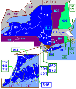
The area is served by 23 area codes:
- 212:Serves Manhattan and is overlaid with 646 and 917.
- 718:Serves all other boroughs of New York City and is overlaid with 347, 917, 929
- 917:Serves all of New York City
- 516:Serves Nassau County
- 631:Serves Suffolk County
- 914:Serves Westchester County
- 845:Serves the Hudson Valley counties of Southern New York State.
- 570:Serves Northeastern Pennsylvania
- 203:Serves Southwestern Connecticut and is overlaid with 475
- 860:Serves the rest of Connecticut not served by 203 or 475
- 201:Serves most of Bergen County, as well as parts of Essex, Hudson and Passaic in Northern New Jersey. and is overlaid with 551.
- 973:Serves portions of Bergen, Essex, Hudson, Morris, Passaic, Sussex and Union Counties in Central New Jersey and is overlaid with 862.
- 908:Serves communities in Union County, Somerset County, northern parts of Middlesex County, Hunterdon County, Warren County, and Morris County as well as some cell phones in Monmouth County in New Jersey.
- 732:includes Middlesex and Somerset counties in Central Jersey and Union County in North Jersey, and Monmouth and northern Ocean counties on the Jersey Shore and overlaid with 848
See also
- United States metropolitan area
- Table of United States Metropolitan Statistical Areas
- Regional Plan Association
- Combined Statistical Area
Notes
- ^ "Population Change for the Ten Most Populous and Fastest Growing Metropolitan Statiscal Areas: 2000 to 2010". U.S. Census Bureau. March 2011. p. 6. http://www.census.gov/prod/cen2010/briefs/c2010br-01.pdf. Retrieved April 12, 2011.
- ^ "Annual Estimates of the Population of Combined Statistical Areas: April 1, 2000 to July 1, 2009" (CSV). 2009 Population Estimates. United States Census Bureau, Population Division. http://www.census.gov/popest/metro/tables/2009/CBSA-EST2009-02.csv. Retrieved March 23, 2010.
- ^ http://transition.fcc.gov/dtv/markets/maps_current/New_York_NY.pdf New York City Designated Market Area map PDF
- ^ Geography Explained (see Change in Labor Market Areas) http://www.labor.ny.gov/stats/lsgeog.shtm
- ^ http://www2.census.gov/geo/maps/puma/puma2k/ct_puma5.pdf
- ^ "Metro-North Railroad". Metropolitan Transportation Authority of the State of New York. http://www.mta.info/mnr/html/generalinformation.html. Retrieved September 27, 2011.
- ^ "Frequently Asked Questions". Hudson River PCBs. New York, NY: U.S. Environmental Protection Agency. http://www.epa.gov/hudson/faqs.htm. Retrieved September 29, 2011.
- ^ Office of Management and Budget – Standards for Defining Metropolitan and Micropolitan Statistical Areas, Sec. 5
- ^ U.S. Census Bureau – Metropolitan and Micropolitan Statistical Areas and Principal Cities (December 2009)
- ^ "GDP by State". Greyhill Advisors. http://greyhill.com/gdp-by-state. Retrieved September 23, 2011.
- ^ http://www.forbes.com/2008/07/15/economic-growth-gdp-biz-cx_jz_0715powercities_slide_4.html?thisSpeed=undefined
- ^ Huddleston, Cameron. "Top 5 Cities with the highest cost of living". Kiplinger's. http://realestate.msn.com/slideshow.aspx?cp-documentid=25275047#2. Retrieved November 12, 2011.
- ^ "Selected statistics on enrollment, teachers, dropouts, and graduates in public school districts enrolling more than 15,000 students, by state: 1990, 2000, and 2006". Digest of Education Statistics 2008. U.S. Department of Education. Institute of Education Sciences, National Center for Education Statistics.. 18 March 2009. pp. 129–139. http://nces.ed.gov/pubs2009/2009020.pdf. Retrieved 2009-04-26.
- ^ "Gold Medal List". US News. pp. 1-2. http://education.usnews.rankingsandreviews.com/best-high-schools/rankings/gold-medal-list?page=1. Retrieved October 28, 2011.
- ^ "SELECTED SOCIAL CHARACTERISTICS IN THE UNITED STATES 2010 American Community Survey 1-Year Estimates". U.S Census Bureau. http://factfinder2.census.gov/faces/tableservices/jsf/pages/productview.xhtml?pid=ACS_10_1YR_DP02&prodType=table. Retrieved November 16, 2011.
- ^ Christie, Les (October 1, 2010). "America's brainiest places to live". CNN Money. http://money.cnn.com/2010/10/01/pf/college/Americas_brainiest_cities/index.htm. Retrieved November 16, 2011.
- ^ a b c Crystal Reports – Op_Stats_Service
- ^ http://factfinder2.census.gov/faces/tableservices/jsf/pages/productview.xhtml?pid=ACS_10_1YR_DP03&prodType=table%7Ctitle=SELECTED ECONOMIC CHARACTERISTICS 2010 American Community Survey 1-Year Estimates|publisher=US Census Bureau
- ^ http://www.infoplease.com/ce6/us/A0859985.html
External references
- Government Census, Table 1.
New York City History · Neighborhoods · Architecture · Skyscrapers · Tourism · Attractions · Culture · Books · Arts · Parks · Cuisine · Dialect · People · Music · Sports · Media · Economy · Companies · Education · Schools · Government · Mayor · Central Park · Council · Fire · Police · Landmarks · Crime · Elections · Geography · Harbor · Gardens · Flag · Environment · Demographics · Enclaves · Transportation · Hospitals · Lists · Images · Portal
 State of New York
Topics - Administrative divisions
- Bibliography
- Congressional districts
- Constitution
- Demographics
- Economy
- Education
- Elections
- Geography
- Government
- History
- Symbols
- People
- Politics
- Transportation
- Visitor Attractions
Regions - Adirondack Mountains
- Allegheny Plateau
- Capital District
- Catskill Mountains
- Central Region (formerly Central-Leatherstocking)
- Central New York
- Champlain Valley
- City of New York
- Finger Lakes
- Holland Purchase
- Hudson Highlands
- Hudson Valley
- Long Island
- Mohawk Valley
- New York Metro
- Niagara Frontier
- North Country
- Ridge and Valley
- Saint Lawrence Seaway
- Shawangunks
- Ski country
- Southern Tier
- Southtowns
- Tech Valley
- Thousand Islands
- Upstate
- Western
Metro areas - Albany / Schenectady / Troy
- Binghamton
- Buffalo / Niagara Falls
- Elmira / Corning
- Glens Falls
- Ithaca
- Jamestown
- Newburgh / Middletown
- New York City
- Poughkeepsie
- Rochester
- Syracuse
- Utica / Rome
Counties - Albany
- Allegany
- Bronx
- Broome
- Cattaraugus
- Cayuga
- Chautauqua
- Chemung
- Chenango
- Clinton
- Columbia
- Cortland
- Delaware
- Dutchess
- Erie
- Essex
- Franklin
- Fulton
- Genesee
- Greene
- Hamilton
- Herkimer
- Jefferson
- Kings
- Lewis
- Livingston
- Madison
- Monroe
- Montgomery
- Nassau
- New York
- Niagara
- Oneida
- Onondaga
- Ontario
- Orange
- Orleans
- Oswego
- Otsego
- Putnam
- Queens
- Rensselaer
- Richmond
- Rockland
- Saint Lawrence
- Saratoga
- Schenectady
- Schoharie
- Schuyler
- Seneca
- Steuben
- Suffolk
- Sullivan
- Tioga
- Tompkins
- Ulster
- Warren
- Washington
- Wayne
- Westchester
- Wyoming
- Yates
 State of New Jersey
Topics Regions - Atlantic Coastal Plain
- Central Jersey
- Delaware River Region
- Delaware Valley
- Gateway Region
- Gold Coast
- Highlands
- Jersey Shore
- Meadowlands
- New York metro area
- North Hudson
- North Jersey
- Pascack Valley
- Piedmont
- Pine Barrens
- Raritan Bayshore
- Ridge-and-Valley Appalachians
- Southern Shore Region
- Skylands Region
- South Jersey
- Tri‑State Region
- West Hudson
Counties Major cities  State of Connecticut
Topics - Index
- Culture
- Constitution
- Delegations
- Elections
- Geography
- Government
- History
- Images
- People
- Visitor Attractions
Regions Counties Cities Places  Commonwealth of Pennsylvania
Topics - Cities
- Politics
- Government
- Delegations
- History
- Geography
- Geology
- Pennsylvanians
- State parks
- Symbols
- Visitor attractions
Metro areas Cities Largest
municipalities- Baldwin
- Berwick
- Bethel Park
- Brentwood
- Carlisle
- Chambersburg
- Columbia
- Darby
- Dunmore
- Elizabethtown
- Emmaus
- Ephrata
- Franklin Park
- Hanover
- Indiana
- Kingston
- Lansdale
- Lansdowne
- Monroeville
- Munhall
- Murrysville
- Norristown
- Penn Hills
- Phoenixville
- Plum
- Pottstown
- State College
- West Chester
- West Mifflin
- Whitehall
- Wilkinsburg
- Wyomissing
- Yeadon
Regions - Allegheny Mountains
- Allegheny National Forest
- Allegheny Plateau
- Atlantic Coastal Plain
- Blue Ridge
- Coal Region
- Cumberland Valley
- Delaware Valley
- Dutch Country
- Endless Mountains
- Happy Valley
- Laurel Highlands
- Lehigh Valley
- Main Line
- Northeast
- Northern Tier
- Northwestern
- Oil Region
- Pennsylvania Highlands
- Piedmont
- The Poconos
- Ridge and Valley
- South Central
- Susquehanna Valley
- Western
- Wyoming Valley
Counties - Adams
- Allegheny
- Armstrong
- Beaver
- Bedford
- Berks
- Blair
- Bradford
- Bucks
- Butler
- Cambria
- Cameron
- Carbon
- Centre
- Chester
- Clarion
- Clearfield
- Clinton
- Columbia
- Crawford
- Cumberland
- Dauphin
- Delaware
- Elk
- Erie
- Fayette
- Forest
- Franklin
- Fulton
- Greene
- Huntingdon
- Indiana
- Jefferson
- Juniata
- Lackawanna
- Lancaster
- Lawrence
- Lebanon
- Lehigh
- Luzerne
- Lycoming
- McKean
- Mercer
- Mifflin
- Monroe
- Montgomery
- Montour
- Northampton
- Northumberland
- Perry
- Philadelphia
- Pike
- Potter
- Schuylkill
- Snyder
- Somerset
- Sullivan
- Susquehanna
- Tioga
- Union
- Venango
- Warren
- Washington
- Wayne
- Westmoreland
- Wyoming
- York
50 largest metropolitan statistical areas in the United States by population - New York
- Los Angeles
- Chicago
- Dallas–Fort Worth
- Philadelphia
- Houston
- Washington
- Miami
- Atlanta
- Boston
- San Francisco–Oakland
- Detroit
- Riverside–San Bernardino
- Phoenix
- Seattle
- Minneapolis–St. Paul
- San Diego
- St. Louis
- Tampa–St. Petersburg
- Baltimore
- Memphis
- Louisville
- Richmond
- Oklahoma City
- Hartford
- New Orleans
- Buffalo
- Raleigh
- Birmingham
- Salt Lake City
World's twenty most populous metropolitan areas 1
 Tokyo-Yokohama
2 Seoul-Incheon
3 Mexico City
4 New York (Tri-State Region)
5 Mumbai
6
 Jakarta
7 São Paulo
8 Delhi
9 Keihanshin
10 Shanghai
16
 Cairo
Cairo
17 Buenos Aires
18 London
19 Beijing
20 KarachiCategories:
- New York metropolitan area
- Metropolitan areas of New Jersey
- New York-White Plains-Wayne, NY-NJ Metropolitan Division (11,732,233)


Wikimedia Foundation. 2010.