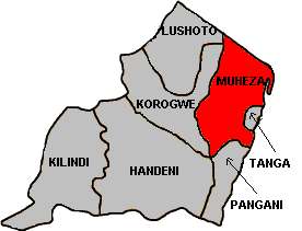
Muheza

Muheza
Muheza
—  District  —
230px
Muheza District in Tanga Region
Muheza is located in Tanzania
Muheza
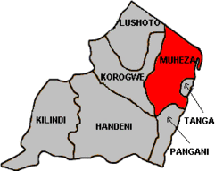
Location in Tanzania
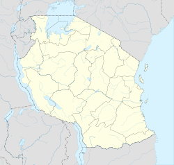
Coordinates: 05°00′00″S 38°55′00″E / 5°S 38.9166667°E / -5; 38.9166667Coordinates: 05°00′00″S 38°55′00″E / 5°S 38.9166667°E / -5; 38.9166667
Country  Tanzania
Region Tanga Region
Government
 - Type District Council
 - District Commissioner Mathew Nasei
Population (2002)
 - Total 278,405
Ethnicity
 - Bondei
 - Sambaa
 - Digo
 - Zigua
 - Segeju
Time zone EAT (UTC+3)
 - Summer (DST) not observed (UTC+3)
Area code(s) 027
Website tanga.go.tz

Muheza is one of the eight districts of Tanga Region in Tanzania. It is bordered to the north by Kenya, to the east by the Tanga and the Indian Ocean, to the south by the Pangani District, and to the west by the Lushoto and Korogwe Districts.

According to the 2002 Tanzania National Census, the population of the Muheza District was 279,423.[1]

Wards

The Muheza District is administratively divided into 35 wards:

  • Bwembwera
  • Daluni
  • Duga
  • Gombero
  • Kicheba
  • Kigongoi
  • Lusanga
  • Kigombe
  • Kilulu
  • Kisiwani (English Meaning: on the island)
  • Kwafungo
  • Kwale
  • Magila
  • Magoroto
  • Majengo (English Meaning: buildings)
  • Manza
  • Maramba
  • Masuguru
  • Mbaramo
  • Mhinduro
  • Misilai
  • Misozwe
  • Mkinga
  • Mkuzi
  • Moa
  • Mtimbwane
  • Mtindiro
  • Mwakijembe
  • Ngomeni
  • Nkumba
  • Pande
  • Potwe
  • Songa
  • Tingeni
  • Zirai

Sources


Wikimedia Foundation. 2010.

Игры ⚽ Поможем написать реферат

Look at other dictionaries:

  • Muheza — Original name in latin Muheza Name in other language Mubeza, Muheza State code TZ Continent/City Africa/Dar es Salaam longitude 5.16667 latitude 38.78333 altitude 183 Population 17000 Date 2012 01 17 …   Cities with a population over 1000 database

  • Muheza District — Admin ASC 2 Code Orig. name Muheza District Country and Admin Code TZ.18.152629 TZ …   World countries Adminstrative division ASC I-II

  • Tanga (Region) — Tanga Basisdaten Staat Tansania …   Deutsch Wikipedia

  • Mkinga —   District   …   Wikipedia

  • Shambala language — Infobox Language name=Shambala nativename=kishambaa familycolor=Niger Congo states=Tanzania speakers= 664,000 fam1=Niger Congo fam2=Atlantic Congo fam3=Volta Congo fam4=Benue Congo fam5=Bantoid fam6=Southern fam7=Narrow Bantu fam8=Central fam9=G… …   Wikipedia

  • Pangani District — Pangani is one of the 7 districts of the Tanga Region. It is bordered to the North by the Muheza District, to the East by the Indian Ocean, to the South by the Pwani Region and to the West by the Handeni District.The center is Pangani.According… …   Wikipedia

  • Korogwe — Infobox Settlement official name = Korogwe other name = native name = nickname = settlement type = motto = imagesize = 300px image caption = St Michael s Cathedral, Korogwe flag size = image seal size = image shield = shield size = image blank… …   Wikipedia

  • Tanga Region — is one of the 26 regions of Tanzania. Its Regional Headquarters is in Tanga.According to the 2002 Tanzania National Census, the region has a population of 1,642,015 people. The Regional Commissioner for Tanga is Abdulaziz Mohamed.The region is… …   Wikipedia

  • Lushoto — (German: Wilhelmtal , William s Valley named after Emperor Wilhelm II) is one of the seven districts of the Tanga Region of Tanzania. It is bordered to the northeast by Kenya, to the east by the Muheza District, to the northwest by the… …   Wikipedia

  • Districts of Tanzania — Tanzania This article is part of the series: Politics and government of Tanzania President (List) Jakaya Kikwete …   Wikipedia

Share the article and excerpts

Direct link
Do a right-click on the link above
and select “Copy Link”