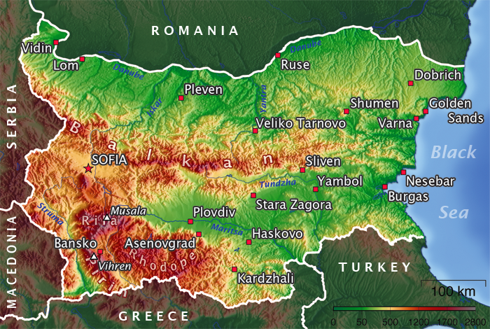
- Geography of Bulgaria
-
Bulgaria 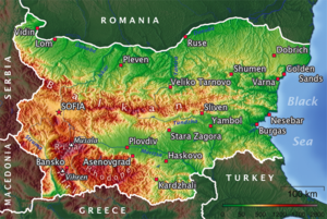
Continent Europe Subregion Balkan Peninsula Geographic coordinates 43°00′N 25°00′E / 43°N 25°E Area
- Total
- WaterRanked 104
110,879 km2
2,390 km2Coastline 354 km Land boundaries 1,808 km Countries bordered Romania 608 km, Serbia 318 km, Republic of Macedonia 148 km, Greece 494 km, Turkey 240 km Maritime claims 200 nm Highest point Musala, 2,925 m Lowest point Black Sea, 0 m Longest river Iskar River, 368 km Largest lake Lake Burgas 27 km2 Land Use
- Arable land
- Permanent
crops
- Forests and
woodlands
- Other
29,9 %
1,9 %
34 %
34,2 % (2005 est.)Climate: Temperate; cold, damp winters; hot, dry summers Terrain: mostly mountains with lowlands in north and southeast Natural resources bauxite, copper, lead, zinc, coal, timber, arable land Natural hazards earthquakes (in certain areas), landslides Environmental issues air and water pollution, deforestation, soil contamination Bulgaria is a country situated in south-eastern Europe, bordering Romania, Serbia, the Republic of Macedonia, Greece, Turkey and the Black Sea. Its northern border with Romania follows the Danube river until Silistra. The land area of Bulgaria is 110,550 square kilometers, slightly larger than that of Iceland or the U.S. state of Tennessee. The country is situated on the west coast of the Black Sea, with Romania to the north, Greece and Turkey to the south, and Serbia and Macedonia to the west. Considering its small size, Bulgaria has a great variety of topographical features. Even within small parts of the country, the land may be divided into plains, plateaus, hills, mountains, basins, gorges, and deep river valleys. The geographic center of Bulgaria is located in Uzana.
Bulgaria features notable diversity with the landscape ranging from the Alpine snow-capped peaks in Rila, Pirin and the Balkan Mountains to the mild and sunny Black Sea coast; from the typically continental Danubian Plain (ancient Moesia) in the north to the strong Mediterranean climatic influence in the valleys of Macedonia and in the lowlands in the southernmost parts of Thrace.
Phytogeographically, Bulgaria straddles the Illyrian and Euxinian provinces of the Circumboreal region within the Boreal kingdom. According to the WWF and to the European Environment Agency's Digital Map of European Ecological Regions, the territory of Bulgaria subdivides into two main ecoregions: the Balkan mixed forests and Rhodope montane mixed forests. Small parts of four other ecoregions also occur on Bulgarian territory.
Geographic coordinates: 43°N 25°E / 43°N 25°ECoordinates: 43°N 25°E / 43°N 25°E
Contents
Boundaries
Although external historical events often changed Bulgaria's national boundaries in its first century of existence, natural terrain features defined most boundaries after 1944, and no significant group of people suffered serious economic hardship because of border delineation. Postwar Bulgaria contained a large percentage of the ethnic Bulgarian people, although numerous migrations into and out of Bulgaria occurred at various times. None of the country's borders was officially disputed in 1991, although nationalist Bulgarians continue to claim that Bulgaria's share of Macedonia—which it shares with both Republic of Macedonia and Greece—is less than just because of the ethnic connection between Macedonians and Bulgarians.
Bulgaria has a total border of about 2,264 km. Rivers account for about 680 km and the Black Sea coast for 400 km; the southern and western borders are mainly defined by ridges in high terrain. The western and northern boundaries are shared with Serbia and Romania, respectively, and the Black Sea coastline constitutes the entire eastern border. The Romanian border follows the Danube for 464 km from the northwestern corner of the country to the city of Silistra and then cuts to the east-southeast for 136 km. The Danube, with steep bluffs on the Bulgarian side and a wide area of swamps and marshes on the Romanian side, is one of the most effective river boundaries in Europe. The line through Dobruja is arbitrary and was redrawn several times according to international treaties. In that process, most inhabitants with strong national preferences resettled in the country of their choice. Borders to the south are with Greece and Turkey, the border with Greece being 491 kilometres long, and the Turkish border having a length of 240 kilometres.
Topography
The relief of Bulgaria is varied. In the relatively small territory of the country there are extensive lowlands, plains, hills, low and high mountains, many valleys and deep gorges. The main characteristic of Bulgaria's topography is alternating bands of high and low terrain that extend east to west across the country. From north to south, those bands (called geomorphological regions) are the Danubian Plain, Stara Planina, the Transitional region and the Rilo-Rhodope Massif. The easternmost sections near the Black Sea are hilly, but they gradually gain height to the west until the westernmost part of the country is entirely high ground.
 View from Ray Resthouse towards the Central Balkan Mountains. The Raysko Praskalo waterfall is in the middle.
Table showing the distribution of the height zones in Bulgaria[1]:
Height zones Height (m) Area (km2) Area (%) Lowlands 0-200 34,858 31,42 Hills 200-600 45,516 41,00 Low mountains 600-1000 16,918 15,24 Medium-high mountains 1000-1600 10,904 9,82 High mountains 1600-2925 2,798 2,52 More than two-thirds of the country is plains, plateaus, or hilly land at an altitude less than 600 m. Plains (below 200 m) make up 31 % of the land, plateaus and hills (200 to 600 m) 41 %, low mountains (600 to 1,000 m) 10 %, medium-sized mountains (1,000 to 1,500 m) 10 %, and high mountains (over 1,500 m) 3 %. The average altitude in Bulgaria is 470 m.
The contemporary relief of the country is a result of continuous geological evolution. Due to that evolution there are magmatic, sedimentary and metamorphic rocks of different origin, age and composition. Their formation began more than 500 million years ago during the Precambrian and continues till now. The Bulgarian lands were often submerged by ancient seas and lakes, some land layers rose others sank. Volcanic eruptions were common both on land and in the water basins.
Danubian plain
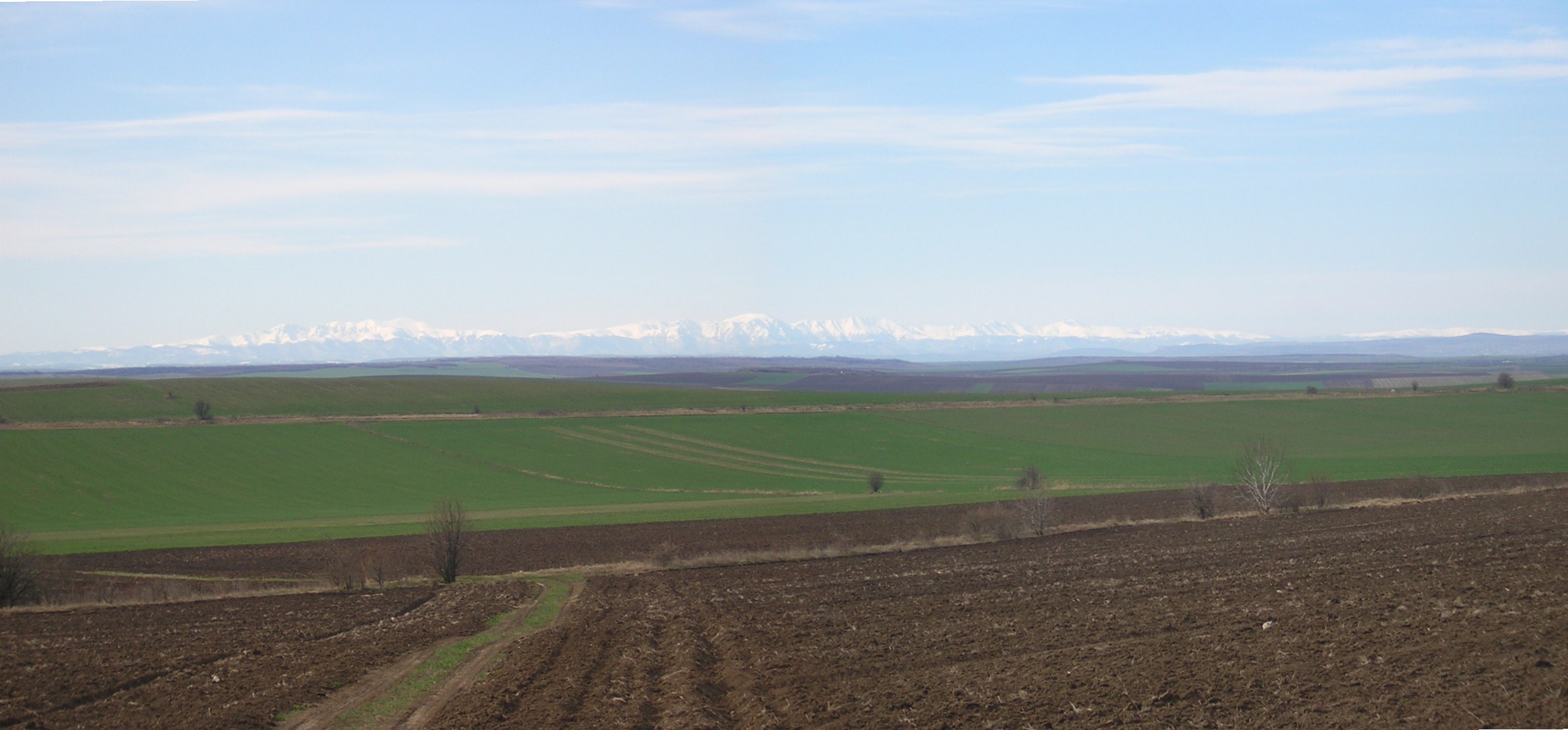
 View across the Danubian Plain towards the central Balkan Mountains 90 km away
The Danubian Plain extends from the western borders to the Black Sea. It encompasses the area between the Danube River, which forms most of the country's northern border, and Stara Planina to the south. It covers the Moesian plate. As a result of the rock weathering processes the relief is uneaven with flat rising grounds along the valleys and plateaus to the east. The plateau slopes gently from cliffs along the river, then it abuts into the low northern mountains of the Balkan range. The highest point is Tarnov Dyal (502 m) in the Shumen Plateau. The valleys of Vit and Yantra divide the Danubian plain into three parts - western, central and eastern. The altitude rises from west to east. To the north the plain has steep shores along the Danube or forms fertile alluvial plains (Vidinska, Chernopolska, Belenska, Pobrezhie, Aidemirska).
Hilly heights and plateaus are typical for the topography of plain. Most of the heights and all plateaus are situated into the eastern parts. There are 14 basalt mounds between Svishtov and the village of Dragomirovo.
Stara Planina
 A view of Stara Planina from Pirdop
The southern edge of the Danubian Plain blends into the foothills of Stara Planina, sometimes thought of as the Bulgarian part of the Carpathian Mountains. The Carpathians resemble a reversed S as they run eastward from the Czech Republic and Slovakia across the northern portion of Romania, swinging southward to the middle of Romania and then running westward, where they are known as the Transylvanian Alps. The mountains turn eastward again at the Iron Gate, a gorge of the Danube River at the Romanian-Serbian border. At that point, they become Stara Planina of Bulgaria.
Stara Planina originates at the Timok Valley in Serbia and run southward towards the Sofia Basin in west central Bulgaria. From there they run east to the Black Sea. The Balkans are about 600 km long and 30 to 50 km wide. They retain their height well into central Bulgaria, where Botev Peak, the highest point in the Balkan Mountains, rises to about 2,376 m. The range then continues at lower altitude to the cliffs of the Black Sea. Through most of Bulgaria, the Balkans form the watershed from which rivers drain north to the Danube River or south to the Aegean Sea. Some smaller rivers in the east drain directly to the Black Sea. The Sredna Gora is a narrow ridge about 160 km long and 1,600 m high, running east to west parallel to the Balkans. Nested between both ranges is the Rose Valley, famous for rose oil used in perfume and liqueurs.
Subbalkan Valleys and Thracian Plain
The southern slopes of the Balkan Mountains and the Sredna Gora give way to the Thracian Plain and the Sofia Basin. Roughly triangular in shape, the Thracian Plain originates at a point east of the mountains near Sofia and broadens eastward to the Black Sea. It includes the Maritsa valley and the lowlands that extend from the river to the Black Sea. Like the Danubian Plateau, much of the Thracian Plain is somewhat hilly and not a true plain. Most of its terrain is moderate enough to cultivate.
The largest basin in Bulgaria is the Sofia Basin. About 24 km wide and 96 km long, the basin contains the capital city and the area immediately surrounding it. The route through basins and valleys from Belgrade to Istanbul (formerly Constantinople) via Sofia has been historically important since Roman times, determining the strategic significance of the Balkan Peninsula. Bulgaria's largest cities were founded on this route. Paradoxically, although the mountains made many Bulgarian villages and towns relatively inaccessible, Bulgaria has always been susceptible to invasion because no natural obstacle blocked the route through Sofia.
Rilo-Rhodope massif
 Panorama of Pirin
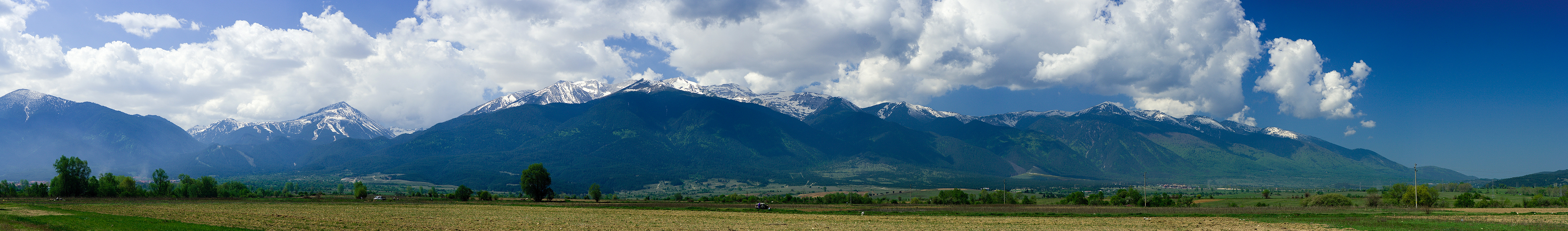
Relatively high mountains occupy the area between the Thracian Plain and Sofia Basin and the Greek border to the south. The western parts consist of three ranges: the Vitosha Mountain south of Sofia, the Rila Mountains further south, and the Pirin Mountains in the southwestern corner of the country. They are the most outstanding topographic feature of Bulgaria and of the entire Balkan Peninsula. The Rila range includes Mount Musala, whose 2,925-metre peak is the highest in any Balkan country. About a dozen other peaks in Rila are over 2,600 meters. The highest peaks are characterized by sparse bare rocks and remote lakes above the tree line. The lower peaks, however, are covered with alpine meadows that give the range an overall impression of green beauty. The Pirin range is characterized by rocky peaks and stony slopes. Its highest peak is Mount Vihren, at 2,915 meters the second-highest peak in Bulgaria. Further east are the extensive Rhodope Mountains.
A significant part of Bulgaria's land is prone to earthquakes. Two especially sensitive areas are the borders of the North Bulgarian Swell (rounded elevation), the center of which is in the Gorna Oryahovitsa area in north-central Bulgaria, and the West Rhodopes Vault, a wide area extending through the Rila and northern Pirin regions to Plovdiv in south-central Bulgaria. Especially strong tremors also occur along diagonal lines running between Skopje in the Republic of Macedonia and Razgrad in northeast Bulgaria, and from Albania eastward across the southern third of Bulgaria through Plovdiv. Sixteen major earthquakes struck Bulgaria between 1900 and 1986, the last two in Strazhitsa on the Skopje-Razgrad fault line. Together the two quakes damaged over 16,000 buildings, half of them severely. One village was almost completely leveled, others badly damaged. Many inhabitants were still living in temporary housing four years later.
Hydrography
Bulgaria has a dense network of about 540 rivers, but with the notable exception of the Danube, most have short lengths and low water-levels.[2]
Most rivers flow through mountainous areas; fewer in the Danubian Plain, Upper Thracian Plain and especially Dobrudzha. Two catchment basins exist: the Black Sea (57% of the territory and 42% of the rivers) and the Aegean Sea (43% of the territory and 58% of the rivers) basins. The longest river located solely in Bulgarian territory, the Iskar River, has a length of 368 km (229 mi). Other major rivers include the Struma and the Maritsa River in the south.
The Balkan Mountains divide Bulgaria into two nearly equal drainage systems. The larger system drains northward to the Black Sea, mainly by way of the Danube River. This system includes the entire Danubian Plateau and a stretch of land running forty-eight to eighty kilometers inland from the coastline. The second system drains the Thracian Plain and most of the higher lands of the south and southwest to the Aegean Sea. Although only the Danube is navigable, many of the other rivers and streams in Bulgaria have a high potential for the production of hydroelectric power and are sources of irrigation water.
Of the Danube's Bulgarian tributaries, all but the Iskar River rise in the Balkan Mountains. The Iskur flows northward to the Danube from its origin in the Rila Mountains, passing through Sofia's eastern suburbs and through a Balkan Mountain valley.
The Danube gets slightly more than 4 % of its total volume from its Bulgarian tributaries. As it flows along the northern border, the Danube averages 1.6 to 2.4 kilometers in width. The river's highest water levels usually occur during June floods; it is frozen over an average of forty days per year.
Several major rivers flow directly to the Aegean Sea. Most of these streams fall swiftly from the mountains and have cut deep, scenic gorges. Maritsa with its tributaries is by far the largest draining all of the western Thracian Plain, all of the Sredna Gora, the southern slopes of the Balkan Mountains, and the northern slopes of the eastern Rhodopes. After it leaves Bulgaria, the Maritsa forms most of the Greek-Turkish border. Struma and the Mesta (which separate the Pirin Mountains from the main Rhodopes ranges) are the next largest Bulgarian rivers flowing to the Aegean. Struma and Mesta reach the sea through Greece.
The Rila and Pirin mountain ranges feature around 260 glacial lakes; the country also has several large lakes on the Black Sea coast and more than 2,200 dam lakes. Many mineral springs exist, located mainly in the south-western and central parts of the country along the faults between the mountains.
The Bulgarian word for spa, баня, transliterated as banya, appears in some of the names of more than 50 spa towns and resorts including Sapareva Banya, Hisarya, Sandanski, Bankya, Varshets, Pavel Banya, Devin, Velingrad and many others.
Climate
 A satellite photo of Bulgaria in December.
Considering its small area, Bulgaria has an unusually variable and complex climate. The country lies between the strongly contrasting continental and Mediterranean climatic zones. Bulgarian mountains and valleys act as barriers or channels for air masses, causing sharp contrasts in weather over relatively short distances. The continental zone is predominant, because continental air masses flow easily into the unobstructed Danubian Plain. The continental influence, stronger during the winter, produces abundant snowfalls; the Mediterranean influence increases during the second half of summer and produces hot and dry weather. The barrier effect of the Balkan Mountains is felt throughout the country: on the average, northern Bulgaria is about one degree cooler and receives about 192 millimetres (7.6 in) more rain than lowlands of southern Bulgaria. Because the Black Sea is too small to be a primary influence over much of the country's weather, it only affects the immediate area along its coastline.
The Balkan Mountains are the northern boundary of the area in which continental air masses circulate freely. The Rhodope Mountains mark the northern limits of domination by Mediterranean weather systems. The area between, which includes the Northern Thracian Plain, is influenced by a combination of the two systems, with the continental predominating. This combination produces a plains climate resembling that of the Corn Belt in the United States, with long summers and high humidity. The climate in this region is generally more severe than that of other parts of Europe in the same latitude. Because it is a transitional area, average temperatures and precipitation are erratic and may vary widely from year to year.
 The north-western Danubian Plain in May
Average precipitation in Bulgaria is about 630 millimetres (24.8 in) per year. Dobrudja in the northeast, the Black Sea coastal area, and small part of the Northern Thracian Plain usually receive less than 500 millimetres. The remainder of the Northern Thracian Plain and the Danubian Plateau get less than the country average; the Northern Thracian Plain is often subject to summer droughts. Higher elevations, which receive the most rainfall in the country, may average over 2,540 millimetres (100 in) per year.
 A view of Aldomirovtsi marsh, with approaching stormclouds surrounding the nearby mountains
The many valley basins scattered through the uplands have temperature inversions resulting in stagnant air. Sofia is located in such a basin, but its elevation (about 530 metres / 1,739 feet) tends to moderate summer temperature and relieve oppressive high humidity. Sofia is also sheltered from the northern European winds by the mountains that surround its troughlike basin. Temperatures in Sofia average −3 °C (26.6 °F) in January and about 28 °C (82.4 °F) in August. The city's rainfall is near the country average, and the overall climate is pleasant.
In summer, temperatures in the southest Bulgaria often exceed 40 °C (104 °F) but remain cooler by the coast. The town of Sadovo, near Plovdiv, has recorded the highest known temperature: 45.2 °C (113.4 °F). The recorded absolute minimum temperature of −39.3 °C (−38.7 °F) occurred west of Sofia, near the town of Trun. The usual temperature around the Stara Planina region averages 10 °C (50 °F) to 15 °C (59 °F).
The highest mountains – over 900 or 1,000 metres (2,953 or 3,281 ft) above sea-level – have an alpine climate. The lowest parts of the Struma and Maritza river valleys are subjected to subtropical (Mediterranean) influence, as are the Eastern Rhodope or Low Rhodope mountains. The extreme south-west part of Bulgaria (near the towns of Sandanski and Petrich) has one of the warmest climates in the country.
The coastal climate is moderated by the Black Sea, but strong winds and violent local storms are frequent during the winter. Winters along the Danube River are bitterly cold, while sheltered low valleys opening to the south along the Greek and Turkish borders may be as mild as areas along the Mediterranean or Aegean coasts.
Environment
Like other former European members of the Council for Mutual Economic Assistance, Bulgaria saw unimpeded industrial growth as a vital sign of social welfare and progress toward the socialist ideal. Because this approach made environmental issues a taboo subject in socialist Bulgaria, the degree of damage by postwar industrial policy went unassessed until the government of Todor Zhivkov (1962–1989) was overthrown in late 1989. The Zhivkov government's commitment to heavy industry and lack of money to spend on protective measures forced it to conceal major environmental hazards, especially when relations with other countries were at stake. Factories that did not meet environmental standards paid symbolic fines and had no incentive to institute real environmental protection measures.
In 1991 Bulgarian environmentalists estimated that 60 % of the country's agricultural land was damaged by excessive use of pesticides and fertilizers and by industrial fallout. In 1991 two thirds of Bulgarian rivers were polluted, and the Yantra River was classified as the dirtiest river in Europe. By that time, about two-thirds of the primary forests had been cut. However, despite its recognition of the need for greater environmental protection, Bulgaria budgeted only 10.4 billion leva.
 Forests and woodlands account for about 38% of Bulgaria's territory. This is a forest in Stara Planina
Perhaps the most serious environmental problem in Bulgaria was in the Danube port city of Rousse. From 1981 to 1989, the chemical pollution that spread from a chlorine and sodium plant across the Danube in Giurgiu, Romania, was a forbidden subject in Bulgaria because it posed a threat to good relations between two Warsaw Pact countries. Chemical plants in Rousse also contributed to the pollution. Citizen environmentalists opposing the situation in Rousse organized the first demonstrations and the first independent political group to oppose the Zhivkov regime. During the Giurgiu plant's first year of operation, chlorine levels in Rousse almost doubled, reaching two times the permissible maximum in the summer of 1990. Over 3,000 families left the city in the 1980s despite government restrictions aimed at covering up the problem. Besides chlorine and its byproducts, the plant produced chemical agents for the rubber industry, and in 1991 some sources reported that the plant was processing industrial waste from Western countries—both activities likely to further damage Rousse's environment. International experts claimed that half of Rousse's pollutants came from Giurgiu, and the others came from Bulgarian industries. In response to the formidable Bulgarian environmental movement, some Bulgarian plants have been closed or have added protective measures; the Giurgiu plant, however, was planning to expand in 1991.
Pollution of agricultural land from a copper plant near the town of Srednogorie provoked harsh public criticism. The plant emitted toxic clouds containing copper, lead, and arsenic. In 1988 it released toxic wastewater into nearby rivers used to irrigate land in the Plovdiv-Pazardzhik Plain, which includes some of Bulgaria's best agricultural land. The groundwater beneath the plain also was poisoned. Work has begun on a plan to drain toxic wastewater from the plant's reservoir into the Maritsa River. Environmental improvements for the copper plant and three other factories in the Plovdiv area (a lead and zinc factory, a chemical factory, and a uranium factory) also were planned, but they would take years to implement.
None of Bulgaria's large cities escaped serious environmental pollution. Statistics showed that 70 to 80 % of Sofia's air pollution is caused by emissions from cars, trucks, and buses. Temperature inversions over the city aggravated the problem. Two other major polluters, the Kremikovtzi AD Metallurgy Works and the Buhovo uranium mine (both in southwestern Bulgaria), contaminated the region with lead, sulfur dioxide, hydrogen sulfide, ethanol, and mercury. The city of Kardzhali became heavily polluted with lead from its lead and zinc complex. In 1973 the petroleum and chemical plant near the Black Sea port of Burgas released large amounts of chlorine in an incident similar to the one in Srednogorie. Environmentalists estimated that the area within a thirty-kilometer radius of the plant was rendered uninhabitable by that release. The air in Burgas was also heavily polluted with carbon and sulfur dioxide in 1990.
In 1990 environmental scientists claimed that two-thirds of Bulgaria's population suffered from the polluted environment to some degree. In 1991 Bulgaria began seeking international assistance in solving environmental problems. Besides joining Romania, Turkey, and Russia in joint scientific studies of the critically polluted Black Sea, Bulgaria actively sought environmental technology and expertise from Western Europe and the United States.
Political geography
Bulgaria's political geography has changed greatly since the restoration of statehood in 1878. Russia, whose military victories had led to its creation, pushed for a "big Bulgaria" that would include much of Macedonia. At the Congress of Berlin, however, the powers insisted upon a much reduced area, divided until 1885 between the principalities of Bulgaria proper and Eastern Rumelia.
An independent kingdom from 1908 to 1946 and thereafter a republic, Bulgaria sought to expand its territory in the two Balkan Wars of 1912-13 and in World Wars I and II. Defeat in the last three conflicts led to a large loss of territory in 1913 and 1919, though the 1940 recovery of the Southern Dobruja was confirmed by the Paris Peace Treaty of 1947.
Natural hazards: earthquakes, landslides
Environment - current issues: air pollution from industrial emissions; rivers polluted from raw sewage, heavy metals, detergents; deforestation; forest damage from air pollution and resulting acid rain; soil contamination from heavy metals from metallurgical plants and industrial wastes
Environment - international agreements:
party to: Air Pollution, Air Pollution-Nitrogen Oxides, Air Pollution-Sulphur 85, Air Pollution-Volatile Organic Compounds, Antarctic-Environmental Protocol, Antarctic Treaty, Biodiversity, Climate Change, Climate Change-Kyoto Protocol, Endangered Species, Environmental Modification, Hazardous Wastes, Law of the Sea, Nuclear Test Ban, Ozone Layer Protection, Ship Pollution (MARPOL 73/78), Wetlands
signed, but not ratified: Air Pollution-Persistent Organic Pollutants, Air Pollution-Sulphur 94Area and boundaries
Area:
total: 110,910 km2
land: 110,550 km2
water: 360 km2Area - comparative: slightly larger than Tennessee
Land boundaries:
total: 1,808 km
border countries: Greece 494 km, The Republic of Macedonia 148 km, Romania 608 km, Serbia 318 km, Turkey 240 kmCoastline: 354 km
Maritime claims:
contiguous zone: 24 nmi (44.4 km; 27.6 mi)
exclusive economic zone: 200 nmi (370.4 km; 230.2 mi)
territorial sea: 12 nmi (22.2 km; 13.8 mi)Elevation extremes:
lowest point: Black Sea 0 m
highest point: Musala 2,925 mResources and land use
Natural resources: bauxite, copper, lead, zinc, uranium, bismuth, nickel, coal, timber, arable land
Land use:
arable land: 43%
permanent crops: 2%
permanent pastures: 14%
forests and woodland: 38%
other: 3% (1999 est.)Irrigated land: 12,370 km2 (1993 est.)
Geography - note: strategic location near Turkish Straits; controls key land routes from Europe to Asia
See also
- Bulgaria
- Extreme points of Bulgaria
- Reservoirs and dams in Bulgaria
- Rivers of Bulgaria
- List of cities in Bulgaria
- List of islands of Bulgaria
- Geography of Europe
References
 This article incorporates public domain material from websites or documents of the Library of Congress Country Studies.
- This article incorporates public domain material from websites or documents of the CIA World Factbook.
Footnotes
Geography of Europe Sovereign
states- Albania
- Andorra
- Armenia
- Austria
- Azerbaijan
- Belarus
- Belgium
- Bosnia and Herzegovina
- Bulgaria
- Croatia
- Cyprus
- Czech Republic
- Denmark
- Estonia
- Finland
- France
- Georgia
- Germany
- Greece
- Hungary
- Iceland
- Ireland
- Italy
- Kazakhstan
- Latvia
- Liechtenstein
- Lithuania
- Luxembourg
- Macedonia
- Malta
- Moldova
- Monaco
- Montenegro
- Netherlands
- Norway
- Poland
- Portugal
- Romania
- Russia
- San Marino
- Serbia
- Slovakia
- Slovenia
- Spain
- Sweden
- Switzerland
- Turkey
- Ukraine
- United Kingdom
- (England
- Northern Ireland
- Scotland
- Wales)
- Vatican City
States with limited
recognitionDependencies
and other territories- Åland
- Faroe Islands
- Gibraltar
- Guernsey
- Jan Mayen
- Jersey
- Isle of Man
- Svalbard
Other entities Climate of Europe Sovereign
states- Albania
- Andorra
- Armenia
- Austria
- Azerbaijan
- Belarus
- Belgium
- Bosnia and Herzegovina
- Bulgaria
- Croatia
- Cyprus
- Czech Republic
- Denmark
- Estonia
- Finland
- France
- Georgia
- Germany
- Greece
- Hungary
- Iceland
- Ireland
- Italy
- Kazakhstan
- Latvia
- Liechtenstein
- Lithuania
- Luxembourg
- Macedonia
- Malta
- Moldova
- Monaco
- Montenegro
- Netherlands
- Norway
- Poland
- Portugal
- Romania
- Russia
- San Marino
- Serbia
- Slovakia
- Slovenia
- Spain
- Sweden
- Switzerland
- Turkey
- Ukraine
- United Kingdom
- (England
- Northern Ireland
- Scotland
- Wales)
- Vatican City
States with limited
recognition- Abkhazia
- Kosovo
- Nagorno-Karabakh
- Northern Cyprus
- South Ossetia
- Transnistria
Dependencies
and other territoriesOther entities - European Union
- Sovereign Military Order of Malta
The Danube Countries 
Cities Tributaries Islands List of crossings Categories:


Wikimedia Foundation. 2010.