- Douglas Municipal Airport (Arizona)
-
For other airports with this name, see Douglas Municipal Airport (disambiguation).
Coordinates: 31°20′33″N 109°30′23″W / 31.3425°N 109.50639°W
Douglas Municipal Airport 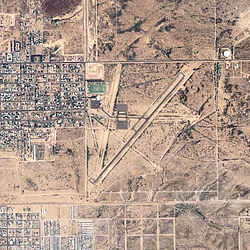
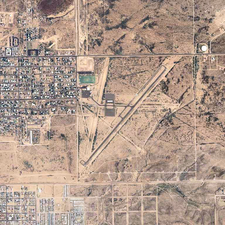
2006 USGS photo IATA: DGL – ICAO: KDGL – FAA LID: DGL Summary Airport type Public Owner City of Douglas Serves Douglas, Arizona Elevation AMSL 4,173 ft / 1,272 m Runways Direction Length Surface ft m 3/21 5,760 1,756 Asphalt 18/36 4,095 1,248 Dirt Statistics (2005) Aircraft operations 7,500 Source: Federal Aviation Administration[1] 
 Douglas MAPLocation of Douglas Municipal Airport, Arizona
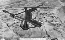 Oblique June 1943 photo of Douglas Army Airfield
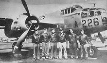 B-25 Aircrew training at Douglas AAF, 1944
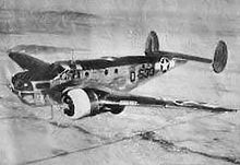 Douglas C-45 Expeditor trainer, 1944
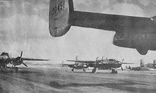 B-25s on the Douglas AAF parking apron, 1944
Douglas Municipal Airport (IATA: DGL, ICAO: KDGL, FAA LID: DGL) is a public airport located two miles (3 km) east of the central business district of Douglas, a city in Cochise County, Arizona, United States. The airport is owned by the city of Douglas.[1] It is not served by any commercial airlines at this time.
Contents
Facilities and aircraft
Douglas Municipal Airport covers an area of 640 acres (260 ha) which contains two runways: 3/21 has an asphalt pavement measuring 5,760 x 75 ft (1,756 x 23 m) and 18/36 has a dirt surface measuring 4,095 x 100 ft (1,248 x 30 m). For the 12-month period ending July 31, 2005, the airport had 7,500 general aviation aircraft operations, an average of 20 per day.[1]
There is also an Arizona State Prison on the site. The area is all flat desert land.
History
World War II
Construction began on Douglas Municipal Airport in June 1942 for the United States Army Air Forces. Land for the airfield was leased from several ranches by the United States Government from several ranches using War Emergency Powers and turned over to the War Department. Some 2,600 acres were set aside for military use.
Known as Douglas Army Airfield, the base included seven operational runways, all over 7,000' in length. The runways included 17L-35R, 17R-35L, 8L-26R, 8R-26L, 3L-21R, 3R-21L, and 12-30. The base had 141 buildings, including personnel barracks, warehouses, aircraft storage hangars, a commissary, civilian quarters, service clubs for officers and enlisted men, a small base hospital, as well as vehicular maintenance shops, recreational facilities, supply storage, specialty training, and ordinance buildings. In addition to the main base, five auxiliary airfields were constructed in the area for emergency and overflow use:
- McNeal Field (Aux #1) 31°36′21″N 109°39′09″W / 31.60583°N 109.6525°W
- Forrest Field (Aux #2) 31°22′27″N 109°40′30″W / 31.37417°N 109.675°W
- Webb Coutland (Elfrida) Field (Aux #3) 31°46′24″N 109°41′49″W / 31.77333°N 109.69694°W
- Hereford Army Airfield (Aux #5) 31°24′57″N 110°08′51″W / 31.41583°N 110.1475°W
Records of Auxiliary Airfield #4 have been lost to time.
Douglas Army Air Field was an advanced flying training school where aviation cadets received their pilot wings and commissions as second lieutenants or appointments as flight officers in the Army Air Force. The base came under the command of 83d Flying Training Wing (Advanced Twin-Engine), Army Air Forces Western Flying Training Command, headquartered at Santa Ana, California. Graduates were then sent to III Bomber Command airfields in the southeast for group assignments on B-26 Marauder or B-25 Mitchell medium bombers, or twin-engined P-38 Lightning IV Fighter Command airfields along the West Coast. Others went to I Troop Carrier Command or Air Transport Command for transport pilot duty.
During World War II, there were about 5,500 troops stationed at Douglas at any one time. It was one of four Army Air Fields in the United States to have both African-American soldiers and WACs, and was the second air field to receive black WACs.
Aircraft assigned to the base were BT-14's, AT-6's, UC-78's, AT-9's, AT-17's, and B-25's
Bisbee-Douglas International Airport
After the war, the facility was inactivated by the War Department on 31 October 1945. After the war, the War Assets Administration was set up to dispose of surplus items, including ships, vehicles, aircraft, and real estate - including many army airfields.
On May 13, 1949, the U.S. government, acting through the War Assets Administration deeded the Douglas Army Airfield to Cochise County. The airfield was named Bisbee-Douglas International Airport and plans were made by the county to prepare the airport to serve as the major air commerce facility in the region.
In 1949-50, the base administration building was remodeled to serve as an airline terminal building. It included offices for airport and airline administration, a passenger lobby, restaurant, rest rooms, and a Flight Service Station. The terminal building remains today, for the most part, in its 1950's vintage configuration
The first Airport Layout Plan (ALP) record drawing for the Bisbee-Douglas International Airport was prepared by Johannessen &. Girand Engineers - Phoenix, Arizona in 1956. The 1956 ALP recommended that Runways 17L-35R, 12-30, and 8R-26L be phased out, along with many taxiways and some of the bituminous aircraft parking aprons. The 1956 plan also recommended development of an industrial area where the current state prison now resides.
The ALP was updated by Blanton & Company of Tucson, Arizona in 1967. By this time, the three runways and their serving taxiways had been phased out. During the 1960's, BDI had scheduled airline service. The critical aircraft being used was the Boeing 727 and Douglas DC-7. The ALP reflected design for these types, and recommended ultimate design for use by the Boeing 747. Recommendations also included extension of Runway 17-35 to an ultimate length of 10,290' (existing length is 7,290').
The ALP was again updated by Blanton &. Company in 1974. This document indicates that the three "phased out" runways were again active, although they were probably not actually useable because of their condition. The recommended extension of Runway 17-35 is continued, along with ultimate installation of an Instrument Landing System (ILS) approach to Runway 17. In 1974, a new 25,000 gallon elevated water tower was constructed. The tower is 140 feet tall, and is lighted with double-fixture obstruction lights.
A 1975 improvement project (ADAP 7-04-0013-01) included replacement of the Medium Intensity Runway Lighting (MIRL) system for Runways 17-35 and 8-26. The electrical vault was rehabilitated at this time, and taxiway guidance signs and a Visual Approach Slope Indicator (VASI-2) system was installed on Runway 17-35. Project engineers were Blanton & Company.
Over recent years, there has been relatively little development activity at the Bisbee-Douglas International Airport.
See also
References
 This article incorporates public domain material from websites or documents of the Air Force Historical Research Agency.
- Shaw, Frederick J. (2004), Locating Air Force Base Sites History’s Legacy, Air Force History and Museums Program, United States Air Force, Washington DC, 2004.
- Manning, Thomas A. (2005), History of Air Education and Training Command, 1942–2002. Office of History and Research, Headquarters, AETC, Randolph AFB, Texas ASIN: B000NYX3PC
External links
- Douglas Municipal Airport (DGL) at Arizona DOT airport directory
- Douglas Army Airfield in World War II
- Resources for this airport:
- AirNav airport information for DGL
- ASN accident history for DGL
- FlightAware airport information and live flight tracker
- SkyVector aeronautical chart for DGL
 Army Air Forces Training Command
Flying Training Flying Schools Eastern Flying Training Command · Central Flying Training Command · Western Flying Training CommandSpecialized Schools Bombardier · Contract Flying · Glider Training · Gunnery · Navigator
Technical Training Eastern Technical Training Command · Central Technical Training Command · Western Technical Training CommandCategories:- 1942 establishments
- Airports in Cochise County, Arizona
- Buildings and structures on the National Register of Historic Places in Arizona
- World War II Desert Airfields
- Airfields of the United States Army Air Forces in Arizona
- USAAF West Coast Training Center


Wikimedia Foundation. 2010.