- Church of All Saints, Leighton Buzzard
-
All Saints Church Church of All Saints, Leighton Buzzard 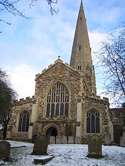
Country England Denomination Church of England Churchmanship Anglo-Catholic Website http://www.allsaintslb.org.uk History Dedication All Saints Architecture Status Church Functional status Active Administration Parish Ouzel Valley Deanery Dunstable Archdeaconry Bedford Diocese St Albans Province Canterbury All Saints Church, Leighton Buzzard is the fine Early English parish church for the town of Leighton Buzzard in the English county of Bedfordshire.
The church is dedicated to All Saints and has a 190 ft spire and some outstanding medieval ironwork, graffiti and roofs "aflutter" with carved angels gifted in the mid 15th century by Alice de la Pole, Countess of Suffolk and grand daughter of Geoffrey Chaucer. It has been described as the cathedral of South Bedfordshire and is probably the finest church in the county. Dating from 1277 it is the second church on the site. Such an old structure requires constant attention through its Preservation Trust.
The Church was severely damaged by fire in 1985. The fire happened just as a restoration programme was nearing completion. It destroyed most of the nave and chancel roofs and caused serious structural damage to the tower, spire, and the vestry areas and a number of the windows were damaged beyond repair. The ring of ten bells was lost as were both the organs. The total cost of the damage exceeded £1.5 million pounds (US$2.4 million dollars). Within 24 hours of the blaze the congregation had begun its second restoration programme in as many years. The 15th century roofs, described as the church’s tour de force, have been repaired and the fine carvings of angels and saints which adorned them have been repaired or replaced. The spire has been stitched and relined with fresh stone. The tower has been stabilised with a massive internal ring beam.
Misericords
All Saints' has 25, late 14th century misericords, the weathering on the stalls probably indicates that they were in a builder's yard for some time - which is not as unusual as it may seem - they are thought to have originated at St Albans Abbey, which was pretty much gutted at the time of the Dissolution of the Monasteries. It is also worth noting that the fan shaped slots at the free ends of the stalls are indicative that they have been shortened at some point.
External links
Coordinates: 51°54′53″N 0°39′55″W / 51.9147°N 0.6652°W
Categories:- Church of England churches in Bedfordshire
- United Kingdom church stubs

Wikimedia Foundation. 2010.