- Columbus Municipal Airport (Indiana)
-
Columbus Municipal Airport 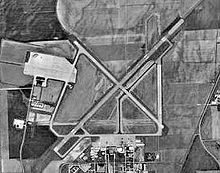
USGS aerial photo - 7 Aug 1997 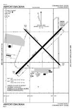
FAA airport diagram IATA: CLU – ICAO: KBAK – FAA LID: BAK Summary Airport type Public Owner City of Columbus Location Columbus, Indiana Elevation AMSL 656 ft / 200 m Coordinates 39°15′43″N 085°53′47″W / 39.26194°N 85.89639°W Runways Direction Length Surface ft m 5/23 6,400 1,951 Asphalt 14/32 5,000 1,524 Asphalt Statistics (2005) Aircraft operations 39,155 Based aircraft 68 Source: Federal Aviation Administration[1] - For the military use of this facility, see Bakalar Air Force Base
Columbus Municipal Airport (IATA: CLU, ICAO: KBAK, FAA LID: BAK) is a city-owned public-use airport located three nautical miles (6 km) north of the central business district of Columbus, a city in Bartholomew County, Indiana, United States.[1]
Although most U.S. airports use the same three-letter location identifier for the FAA and IATA, this airport is assigned BAK by the FAA and CLU by the IATA. The airport's ICAO identifier is KBAK.[2]
 Airport terminal and control tower
Contents
History
Columbus Municipal Airport is on the site of the former World War II Atterbury Army Airfield and United States Air Force Bakalar Air Force Base.
Facilities and aircraft
Columbus Municipal Airport covers an area of 2,000 acres (810 ha) at an elevation of 656 feet (200 m) above mean sea level. It has two asphalt paved runways: 5/23 is 6,400 by 150 feet (1,951 x 46 m) and 14/32 is 5,000 by 100 feet (1,524 x 30 m).[1]
For the 12-month period ending December 31, 2005, the airport had 39,155 aircraft operations, an average of 107 per day: 91% general aviation and 9% military. At that time there were 68 aircraft based at this airport: 72% single-engine, 16% multi-engine, 7% jet and 4% helicopter.[1]
References
- ^ a b c d FAA Airport Master Record for BAK (Form 5010 PDF), effective 2009-05-07.
- ^ Great Circle Mapper: CLU / KBAK - Columbus, Indiana
External links
- Columbus Municipal Airport
- Aerial photo from Indiana Department of Transportation
- FAA Airport Diagram for Columbus Municipal (BAK) (PDF), effective 20 October 2011
- FAA Terminal Procedures for Columbus Municipal (BAK), effective 20 October 2011
- Resources for this airport:
- AirNav airport information for KBAK
- ASN accident history for CLU
- FlightAware airport information and live flight tracker
- NOAA/NWS latest weather observations
- SkyVector aeronautical chart, Terminal Procedures for KBAK
Airports in Indiana Primary Relief General Anderson Municipal Airport · Arens Field · Columbus Municipal Airport · Crawfordsville Municipal Airport · DeKalb County Airport · Delaware County Airport · Delphi Municipal Airport · Elkhart Municipal Airport · Frankfort Municipal Airport · Freeman Municipal Airport · French Lick Municipal Airport · Fulton County Airport · Gary/Chicago International Airport · Goshen Municipal Airport · Greensburg-Decatur County Airport · Greenwood Municipal Airport · Virgil I. Grissom Municipal Airport · Huntingburg Airport · Huntington Municipal Airport · Indianapolis Downtown Heliport · Jasper County Airport · Kendallville Municipal Airport · Kentland Municipal Airport · Kokomo Municipal Airport · La Porte Municipal Airport · Logansport/Cass County Airport · Madison Municipal Airport · Marion Municipal Airport · Mettel Field · Michigan City Municipal Airport · Monroe County Airport · New Castle-Henry County Municipal Airport · North Vernon Airport · Paoli Municipal Airport · Perry County Municipal Airport · Peru Municipal Airport · Plymouth Municipal Airport · Porter County Regional Airport · Portland Municipal Airport · Purdue University Airport · Putnam County Airport · Randolph County Airport · Richmond Municipal Airport · Salem Municipal Airport · Shelbyville Municipal Airport · Sheridan Airport · Smith Field · Starke County Airport · Tri-State Steuben County Airport · Sullivan County Airport · Terre Haute International Airport · Wabash Municipal Airport · Warsaw Municipal Airport · White County Airport
Categories:- Airports in Indiana
- Buildings and structures in Bartholomew County, Indiana
- Transportation in Bartholomew County, Indiana


Wikimedia Foundation. 2010.