- Naburn
-
Coordinates: 53°54′09″N 1°05′21″W / 53.90263°N 1.08919°W
Naburn 
 Naburn
Naburn shown within North YorkshirePopulation 470 OS grid reference SE599455 Parish Naburn Unitary authority City of York Ceremonial county North Yorkshire Region Yorkshire and the Humber Country England Sovereign state United Kingdom Post town YORK Postcode district YO19 Dialling code 01904 Police North Yorkshire Fire North Yorkshire Ambulance Yorkshire EU Parliament Yorkshire and the Humber UK Parliament York Outer List of places: UK • England • Yorkshire Naburn is a small village and civil parish in the unitary authority of the City of York in North Yorkshire, England. It lies on the eastern side of the River Ouse about 4 miles (6.4 km) south of York. According to the 2001 census the parish had a population of 470. Prior to 1996 it had been part of the Selby district.
Contents
History
Naburn was the site of Naburn Hospital, a psychiatric hospital ,formerly known as York City Asylum, until its closure in 1988. Both Acres and Lodge farms belonged to Naburn Hospital, the former York City Lunatic Asylum, for which they were acquired in 1899 and 1914 respectively. The site also included a maternity hospital.[1][2]
In 1739 a ferry was situated just to the west of Naburn Hall, but by the early 19th century was in competition with a horse and foot road that led from the village street past the hall and across the ings to a ferry close to Acaster Malbis village. The latter ferry is said to have been started by the Thompsons of Escrick after Beilby Thompson married Dame Sarah Dawes to provide a connexion with her estate at Acaster. Due to increased traffic, it proved a nuisance to the Palmes family at Naburn Hall. In 1824 they closed the road with the ferry moving to a point near the middle of the village. The new ferry, for passengers and vehicles, was later worked by wheel and chain and was closed in 1956.[1]
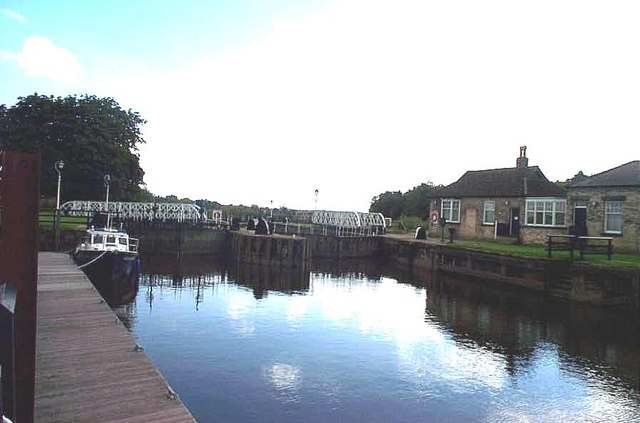
A weir was made at Naburn, a mile downstream from the village, in 1741 and a 'dam' or weir and a lock were opened in 1757. As a result this created an island on which a water-mill was later built. A second, larger, lock was constructed beside the old one in 1888 and opened by Prince Albert Victor. The York-Selby railway line crossed the River Ouse just north of the village by way of a swing bridge built in 1871. Naburn station was closed to passengers in 1953 and to goods in 1964, and in 1983 the Selby Diversion was opened and the line via Naburn was closed and turned into a cycle track.[1]
There were three alehouses in Naburn in the 1750s and 1760s, but by 1822 only the "Horse Shoe" remained. In 1872 it was renamed the "Blacksmiths' Arms".[1]
A sewerage works for York, covering about 20 acres, was opened beside the river in Naburn in 1895 and has been extended several times.[1]
Before the Norman Conquest, Naburn was held by two Saxons, named Turgot and Turchil. After the Conquest, it was given, to Robert de Todeni, one of the Conquerors standard-bearers, from whom the Rutland family is descended.[3] In 1086 there were two main estates recorded at Naburn, the one belonging to Robert de Todeni and the other to the King. The larger estate passed by way of marriage to the Aubignys until it passed, in 1284-5, to Robert de Ros. The Ros interest was mentioned as late as 1434. About 1200 the Watervill were lords of the manor of Naburn under the Aubignys. Richard de Watervill assigned the manor to William Palmes in 1226 and the estate remained in the Palmes Family until the death of Commander George Bryan Palmes in 1974. The current head of the Palmes family is Antony Bryan Palmes (born 4/5/1930).[1]
Geography
Most of the parish is a little over 25 feet (7.6 m) above sea level with the extensive nearby ings being even lower. The village is surrounded by arable farmland and patches of woodland.[1]
The soil consists of the alluvium of the Ouse flood-plain and patches of glacial sand and gravel east of the village and in the north-west is covered with outwash sand and clay.[1]
Streams draining into the Ouse include Wood Dike, which forms a short section of the southern parish boundary, and Howden Dike, which joins the river at the north end of the village. The Ouse forms the entire parish boundary on the west.[1]
Naburn is 2.5 miles north west of Deighton, and about the same distance west of Crockey Hill, though the road distance is a mile longer. To the west of Naburn, the lack of a road crossing over the River Ouse means a long road journey to the relatively close villages of Acaster Malbis and Bishopthorpe. Naburn is 3 miles north of Stillingfleet and 4 miles south of York.
Governance
Naburn lies in the Wheldrake Ward of the City of York unitary authority. As of 2010, it is represented by Christian Vassie, aa member of the lcoal Liberal Democrat Party.[4] The village also has its own Parish Council.[5]
Demography
The population in 1801 was 363, increasing to 574 in 1901. The total had fallen to 537 by 1951, 473 by 1961, and 371 by 1971.[1] According to the 2001 census the parish had a population of 470.
Economy
Naburn has one public house, the Blacksmiths Arms and a small sub post office.
Transport
Arriva run a bus service that stops in the village as part of its York to Selby route.[6]
Education
There has been a school in the village since 1743. The school was replaced by a National school, built nearby in Back Lane, in 1871, and enlarged in 1889.[1] It is now a Church of England Primary School.[7] As of 2010, the school falls within the catchement area of Fulford School for secondary education.[8]
Religious sites
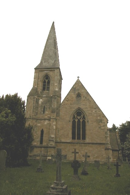
A farm-house called Naburn Hill or White Cock Hall, beside the York road in the north-east of the parish, was used for Wesleyan Methodist worship in 1851 and was registered for the purpose in 1853, but by 1896 had fallen into disuse. The church of St. Matthew was rebuilt on its present site in 1854.[3]
Sports and leisure
The Yorkshire Ouse Sailing Club, founded in 1938, has a club house near the former ferry. At the north end of the village, a marina was opened in 1970.[1]
Landmarks
Naburn Hall is a Grade II listed building.[9] Naburn Hall had been in possession of the Palmes family since 1226 and was passed down the generations until 1974. The house was rebuilt in 1735 and underwent alterations in 1818 and enlargement 1870. It consists of a three-storeyed square main block, with a two-storeyed wing. The 18th-century coach-house has a clock turret and bellcot.[1]
Acres House was built in 1774 and formed part of the old hospital.[1]
Gallery
Views of Naburn 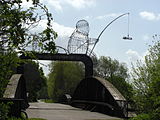 Naburn railway bridge near York, showing "The Fisherman" iron cage sculpture
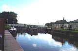 Naburn Locks looking south.
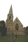 Naburn Church
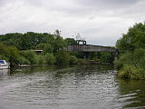 Naburn Bridge
 River Ouse at Naburn.
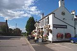 Naburn, The Blacksmiths Public House
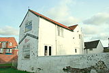 The Yorkshire Ouse Sailing Club at Naburn
References
- ^ a b c d e f g h i j k l m n "Village History". http://www.british-history.ac.uk/report.aspx?compid=23009. Retrieved 2010-12-07.
- ^ "Asylum". http://www.countyasylums.com/mentalasylums/naburn.htm. Retrieved 2010-12-04.
- ^ a b Bulmer's Topography, History and Directory (Private and Commercial) of North Yorkshire 1890. S&N Publishing. 1890. ISBN 1861502990.
- ^ "Councillor". http://democracy.york.gov.uk/mgFindCouncillor.aspx?XXR=0&AC=WARD&WID=369. Retrieved 2010-12-04.
- ^ "Parish Council". http://democracy.york.gov.uk/mgParishCouncilDetails.aspx?ID=292. Retrieved 2010-12-04.
- ^ "Bus service". http://www.arrivabus.co.uk/serviceInformation.aspx?id=2591. Retrieved 2010-12-04.
- ^ "Primary School". http://www.naburnschool.com/. Retrieved 2010-12-04.
- ^ "Secondary education". http://www.york.gov.uk/content/45255/31906/Secondary_school_places/FULFORD_SCHOOL.pdf. Retrieved 2010-12-04.
- ^ "Naburn Hall". http://www.britishlistedbuildings.co.uk/en-326195-naburn-hall-naburn. Retrieved 2010-12-07.
External links
 Media related to Naburn at Wikimedia CommonsCategories:
- Villages in North Yorkshire
- Villages and areas in the City of York
- Civil parishes in North Yorkshire


Wikimedia Foundation. 2010.