- Geography of Sweden
-
Sweden 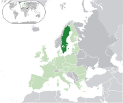
Continent Europe Subregion Scandinavia Geographic coordinates 62°00′N 15°00′E / 62°N 15°E Area
- total
- waterRanked 56th
450,295 km²
39,960- km² (8.69%)Coastline 3,218 km (2,000 mi) Land boundaries 2,333 km (1,550 mi) Countries bordered Norway 1,619 km
Finland 614 kmHighest point Kebnekaise, 2,111 m / 6,926 ft Lowest point Kristianstad, -2.41 m Longest river Klarälven-Göta älv, 720 km (447.4 mi) Largest inland body of water Vänern 5,648 km² (3,510 sq mi) Land use
- Arable land
- Permanent
crops
- Other
5.93 %
0.01 %
94.06 % (2005 est.)Irrigated land 1,150 km² (2003) Climate: Temperate to subarctic Terrain: Flat lowlands, mountains Natural resources Iron ore, copper, lead, zinc, gold, silver, tungsten, uranium, arsenic, feldspar, timber, hydropower Natural hazards Ice flow Environmental issues Acid rains, eutrophication Sweden is a country in Northern Europe on the Scandinavian Peninsula. Its borders are Norway to the west; Finland to the northeast; and the Baltic Sea and Gulf of Bothnia to the east and south.
Sweden has a long coastline on the eastern side and the Scandinavian mountain chain (Skanderna) on the western border, a range that separates Sweden from Norway. It has maritime borders with Denmark, Germany, Poland, Russia, Lithuania, Latvia and Estonia, and it is also linked to Denmark (southwest) by the Öresund Bridge. At 450,295 km2 (173,860 sq mi), Sweden is the 55th largest country in the world. It is the 5th largest in Europe and the largest in Northern Europe.
Contents
Terrain
 Map of Sweden.
Much of Sweden is heavily forested, with 78% of the country being forest and woodland, while farmland constitutes only 8% of land use. Southern Sweden is predominantly agricultural, with increasing forest coverage northward. Mountains and hills are dominant in the west. About 15% of Sweden lies north of the Arctic Circle.
The lowest elevation in Sweden is in the bay of Lake Hammarsjön, near Kristianstad at
−2.41 m (−7.91 ft) below sea level. The highest point is Kebnekaise at 2,111 m (6,926 ft) above sea level.The highest population density is in the Öresund region in southern Sweden and in the valley of lake Mälaren near to Stockholm. Gotland and Öland are Sweden's largest islands; Vänern and Vättern are its largest lakes. Vänern is the third largest in Europe, after Lake Ladoga and Lake Onega in Russia.
Sweden consists of 39,960 km² of water area, constituting around 95,700 lakes.[1] The lakes are sometimes used for water power plants, especially the large northern rivers and lakes. The two largest islands are Gotland and Öland in the southeast. They each have their own culture, most notably Gotland with the old, largely intact and heritage-filled city Visby.
Political divisions
Provinces
Main articles: Provinces of Sweden and Lands of SwedenSweden has 25 provinces or landskap (landscapes), based on culture, geography and history: Bohuslän, Blekinge, Dalarna, Dalsland, Gotland, Gästrikland, Halland, Hälsingland, Härjedalen, Jämtland, Lapland, Medelpad, Norrbotten, Närke, Skåne, Småland, Södermanland, Uppland, Värmland, Västmanland, Västerbotten, Västergötland, Ångermanland, Öland and Östergötland.
While these provinces serve no political or administrative purpose, they play an important role for people's self-identification. The provinces are usually grouped together in three large lands (landsdelar): the northern Norrland, the central Svealand and southern Götaland. The sparsely populated Norrland encompasses almost 60% of the country.
Counties
Main article: Counties of Sweden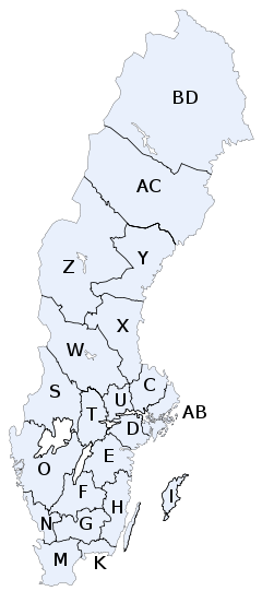
Administratively Sweden is divided into 21 counties or län. In each county there is a County Administrative Board or länsstyrelse which is appointed by the government.
In each county there is also a separate County Council or landsting, which is the municipal representation appointed by the county electorate.
- K = Blekinge County
- W = Dalarna County
- I = Gotland County
- X = Gävleborg County
- N = Halland County
- Z = Jämtland County
- F = Jönköping County
- H = Kalmar County
- G = Kronoberg County
- BD = Norrbotten County
- M = Skåne County
- AB = Stockholm County
- D = Södermanland County
- C = Uppsala County
- S = Värmland County
- AC = Västerbotten County
- Y = Västernorrland County
- U = Västmanland County
- O = Västra Götaland County
- T = Örebro County
- E = Östergötland County
The letters shown were on the vehicle registration plates until 1973 .
Municipalities
Main article: Municipalities of Sweden Lapporten mountain pass in Lapland
Each county is further divided into municipalities or kommuner, ranging from only one (in Gotland County) to forty-nine (in Västra Götaland County). The total number of municipalities is 290.
The northern municipalities are often large in size, but have small populations – the largest municipality is Kiruna with an area as large as the three southern provinces in Sweden (Scania, Blekinge and Halland) combined, but it only has a population of 25,000, and its density is about 1 / km².
 Population density in the counties of Sweden.
people/km²
0-9.910-24.925-49.950-99.9100-199.9200+Population
Sweden has a population of about 9 million. The north is less populated than the southern and central parts, mostly because of its colder climate.
Cities
Main articles: Cities in Sweden and Urban areas in SwedenCities and towns in Sweden are not political or administrative entities but localities or urban areas, independent of the municipal subdivision. The largest city, in terms of population, is the capital Stockholm, in the east, the dominant city for culture and media, with a population of 1,250,000. The second largest city is Gothenburg, with 510,500, in the west. The third largest is Malmö in the south, with 258,000. The largest city in the north is Umeå with 76,000 inhabitants.
Natural resources
Sweden's natural resources include copper, gold, hydropower, iron ore, lead, silver, timber, uranium, and zinc.
Environment
Acid rain has become an issue because it is damaging soils and lakes and polluting the North Sea and the Baltic Sea. The HBV hydrology transport model has been used to analyze nutrient discharge to the Baltic from tributary watersheds.
Extreme points
 KebnekaiseSmygehukStora DrammenKatajaTreriksrösetVattenriketExtreme points of Sweden
The extreme points of Sweden include the coordinates that are farthest north, south, east and west in Sweden, and the ones that are at the highest and the lowest elevations in the country. The northern-most point in Sweden is Treriksröset, where the borders of Sweden, Norway, and Finland meet. The southern-most point is Smygehuk; the western-most is Stora Drammen, and the eastern-most is Kataja. The highest point in Sweden is Kebnekaise at 2,104 metres (6,903 ft). The lowest point is in the Kristianstads Vattenrike Biosphere Reserve, and it is 2.41 metres (7.91 ft) below sea level.
The latitude and longitude are expressed in decimal degree notation, in which a positive latitude value refers to the northern hemisphere, and a negative value refers to the southern hemisphere. Additionally, a negative elevation value refers to land below sea level. The coordinates used in this article are sourced from Google Earth, which makes use of the World Geodetic System (WGS) 84, a geodetic reference system.
Latitude and longitude
 Treriksröset, Sweden's northern-most point
 Signpost in the harbour of Smygehuk, Sweden's southern-most point
Sweden's northern-most point is Treriksröset, in the Lapland province,[2] where the borders of Sweden, Norway, and Finland meet. The closest Swedish city to the area is Kiruna, which is Sweden's northern-most city.[3] Sweden's southern-most point is in the harbour of the fishing village Smygehuk, near the city of Trelleborg,[4] which borders the Baltic Sea.[5] At the pier of the harbour, a signpost displays the exact position of the point, as well as the distance to Treriksröset, Stockholm, Berlin, Paris, and Moscow.[4]
Sweden's western-most point is on Stora Drammen, an islet in Skagerrack outside the coast of Bohuslän.[6] Seabirds and harbor seals have colonies on the islet, but it is uninhabited by humans.[7] Sweden's eastern-most point is on Kataja,[6] an islet south of Haparanda in the Bothnian Bay.[8][dead link] The islet is divided between Sweden and Finland. The border was established in 1809, after the Finnish War, between what was previously two islets, a Swedish one called Kataja and a smaller Finnish one called Inakari. Since 1809, post-glacial rebound has caused the sea level in the region to drop relative to land level, joining the two islets.[9] If counting the mainland only, Stensvik in Strömstad is Sweden's western-most point,[10] and Sundholmen in Haparanda is the eastern-most point.[11]
Heading Location Province Bordering entity Coordinates[12] Ref North Treriksröset, Kiruna Lapland Troms, Norway, and Lapland, Finland 69°03′36″N 20°32′55″E / 69.06°N 20.548611°E [6][3][13] South Smygehuk, Trelleborg Scania Baltic Sea 55°20′13″N 13°21′34″E / 55.336944°N 13.359444°E [6][5][14] West Stora Drammen, Strömstad Bohuslän Skagerrak 58°55′43″N 10°57′27″E / 58.928611°N 10.9575°E [6][15][16] West (mainland) Stensvik, Strömstad Bohuslän Skagerrak 58°59′50″N 11°06′47″E / 58.997222°N 11.113056°E [10][17][18] East Kataja, Haparanda Norrbotten Bothnian Bay 65°42′39″N 24°09′21″E / 65.710833°N 24.155833°E [6][19][20] East (mainland) Sundholmen, Haparanda Norrbotten Torne River, and the Bothnian Bay 65°48′54″N 24°09′02″E / 65.815°N 24.150556°E [11][21][13] Elevation
 At 2,104 metres (6,903 ft), Kebnekaise is Sweden's highest point.
The highest point in Sweden is Kebnekaise, which stands at 2,104 metres (6,903 ft). It is in the Scandinavian Mountains chain, in the province of Lapland.[22][23] The mountain has two peaks, of which the glaciated southern one is the highest at 2,104 metres (6,903 ft).[22] The northern peak, which stands at 2,096 metres (6,877 ft), is free of ice. Although the south top is traditionally said to be 2,111 metres (6,926 ft) high,[2] new measurements have shown that the glacier has shrunk; therefore the summit is not as high as earlier.[22] Other points of comparable height in the vicinity of Kebnekaise include Sarektjåkka at 2,089 metres (6,854 ft), and Kaskasatjåkka at 2,076 metres (6,811 ft).[6]
Sweden's lowest point, which is 2.41 metres (7.91 ft) below sea level, is in the Kristianstads Vattenrike Biosphere Reserve in the city of Kristianstad.[2] The point is at the bottom of what was once Nosabyviken, a bay on the lake of Hammarsjön. The bay was drained in the 1860s by John Nun Milner, an engineer, to get more arable land for Kristianstad.[24]
Extremity Name Elevation Location Province Coordinates[12] Ref Highest Kebnekaise 2,104 metres (6,903 ft) Scandinavian Mountains Lapland 67°54′00″N 18°31′00″E / 67.9°N 18.516667°E [22][23][25] Lowest Kristianstads Vattenrike Biosphere Reserve −2.41 metres (−7.91 ft) Kristianstad Scania 56°01′18″N 14°10′44″E / 56.021581°N 14.178878°E [2][8][24] See also
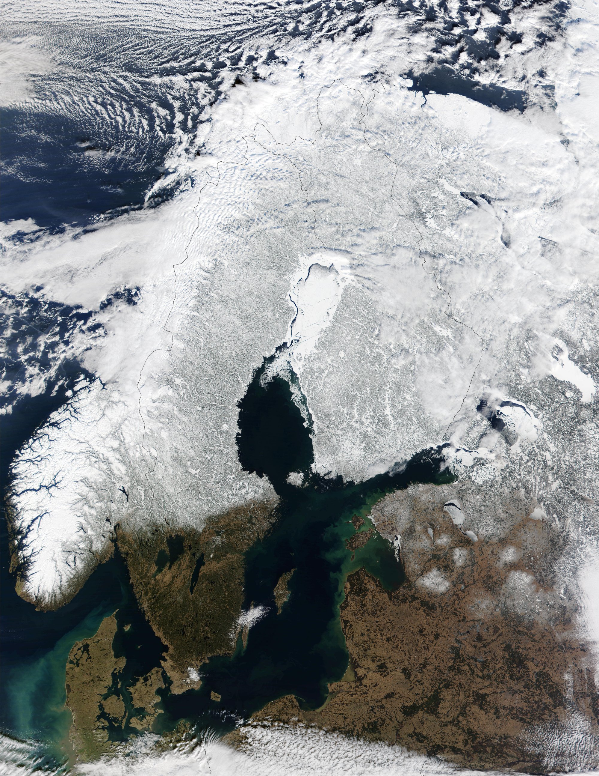
 In this true-color scene on March 15, 2002, much of Sweden can be seen covered by snow.
- Geographical center of Sweden
- List of cities in Sweden
- List of islands of Sweden
- List of lakes in Sweden
- List of municipalities of Sweden
- List of national parks of Sweden
- List of rivers in Sweden
- Climate of Sweden
References
- ^ [1]
- ^ a b c d "Sweden: Geography". CIA – The World Factbook. https://www.cia.gov/library/publications/the-world-factbook/geos/sw.html. Retrieved 2008-10-28.
- ^ a b "Google Maps (Treriksröset)". Google. http://maps.google.com/maps?ll=69.06,20.548611&spn=0.01,0.01&q=69.06,20.548611. Retrieved 2008-10-28.
- ^ a b "Trelleborgs kommun - Smygehuk" (in Swedish). Trelleborg.se. May 15, 2003. http://www.trelleborg.se/Lar-kanna-Trelleborg/Upptack-Trelleborg/Utflyktsmal/Smygehuk/. Retrieved 2008-10-28.
- ^ a b "Google Maps (Smygehuk)". Google. http://maps.google.com/maps?ll=55.336944,13.359444&spn=0.01,0.01&q=55.336944,13.359444. Retrieved 2008-10-28.
- ^ a b c d e f g "Geografiska uppgifter (Geographical data)" (in Swedish and English) (PDF). Statistiska centralbyrån (Statistics Sweden). http://www.scb.se/statistik/AA/OV0904/2000I02/A01S%C3%850201_03.pdf. Retrieved 2008-10-28.
- ^ "Reportage - Stora Drammen" (in Swedish). Sweden Offroad Tour. http://www.swedenoffroad.com/sv/reportage/pic6.html. Retrieved 2008-10-28.
- ^ a b "Svenskt ortnamnsregister" (in Swedish). Sverigeatlas.se. http://www.sverigeatlas.se/. Retrieved 2008-10-28.
- ^ Tingbrand, Per (1984) (in Swedish). Kataja - Sveriges östligaste skär. Västkustrapsodi. Borås: Svenska Kryssarklubben. ISBN 91-86069-07-7.
- ^ a b "Eniro Maps (Stensvik)" (in Swedish). Eniro. http://kartor.eniro.se/query?what=map&mapstate=8;11.113056;58.997222. Retrieved 2008-10-29.
- ^ a b "Sundholmen är ett internationellt centrum i Bottenviksbågen och Barentsområdet" (in Swedish). Haparanda.se. Archived from the original on May 3, 2008. http://web.archive.org/web/20080503221325/http://www.haparanda.se/topplankar/forvaltning/kommunledningsforvaltning/samhallsbyggnadskontor/planer/arkiv/sundholmen.4.19caa05410ae9b91f5a8000531.html. Retrieved Mar 03, 2008.
- ^ a b Coordinates obtained from Google Earth. Google Earth makes use of the WGS84 geodetic reference system.
- ^ a b Almqvist & Wiksells stor-atlas, p. 4
- ^ Almqvist & Wiksells stor-atlas, p. 7
- ^ "Google Maps (Stora Drammen)". Google. http://maps.google.com/maps?ll=58.928611,10.9575&spn=0.01,0.01&q=58.928611,10.9575. Retrieved 2008-10-11.
- ^ "Eniro Maps (Stora Drammen)" (in Swedish). Eniro. http://kartor.eniro.se/query?what=map&mapstate=8;10.9575;58.928611. Retrieved 2008-10-29.
- ^ Almqvist & Wiksells stor-atlas, p. 6
- ^ "Förutsättningar, analys och överväganden" (in Swedish) (PDF). Strömstad.se. http://www.stromstad.se/download/18.3eb156c911583e457c4800012463/F%C3%B6ruts%C3%A4ttningar%2Banalyser%2Boch%2B%C3%B6verv%C3%A4ganden.pdf. Retrieved 2008-10-29.
- ^ "Google Maps (Kataja)". Google. http://maps.google.com/maps?ll=65.710833,24.155833&spn=0.01,0.01&q=65.710833,24.155833. Retrieved 2008-10-29.
- ^ "Eniro Maps (Kataja)" (in Swedish). Eniro. http://kartor.eniro.se/query?what=map&mapstate=8;24.155833;65.710833. Retrieved 2008-10-29.
- ^ "Google Maps (Sundholmen)". Google. http://maps.google.com/maps?ll=65.815,24.150556&spn=0.01,0.01&q=65.815,24.150556. Retrieved 2008-10-29.
- ^ a b c d Annika, Rydman (Augusti 18, 2008). "Sydtoppen fortfarande högst i Sverige" (in Swedish). Dagens Nyheter. http://www.dn.se/DNet/jsp/polopoly.jsp?d=597&a=817545. Retrieved 2008-10-27.
- ^ a b "Google Maps (Kebnekaise)". Google. http://maps.google.com/maps?ll=67.9,18.516667&spn=0.1,0.1&q=67.9,18.516667. Retrieved 2008-10-11.
- ^ a b "Lägsta punkten (Lowest point)" (in Swedish). Kristianstad.se. Archived from the original on Mar 6, 2008. http://web.archive.org/web/20080306131149/http://www.vattenriket.kristianstad.se/plats/lagsta_punkten.htm. Retrieved Mar 06, 2008.
- ^ Almqvist & Wiksells stor-atlas, p. 18
- (in Swedish) Almqvist & Wiksells stor-atlas. Stockholm: Liber AB. November 2003. ISBN 9121206805. OCLC 243941349.
Geography of Europe Sovereign
states- Albania
- Andorra
- Armenia
- Austria
- Azerbaijan
- Belarus
- Belgium
- Bosnia and Herzegovina
- Bulgaria
- Croatia
- Cyprus
- Czech Republic
- Denmark
- Estonia
- Finland
- France
- Georgia
- Germany
- Greece
- Hungary
- Iceland
- Ireland
- Italy
- Kazakhstan
- Latvia
- Liechtenstein
- Lithuania
- Luxembourg
- Macedonia
- Malta
- Moldova
- Monaco
- Montenegro
- Netherlands
- Norway
- Poland
- Portugal
- Romania
- Russia
- San Marino
- Serbia
- Slovakia
- Slovenia
- Spain
- Sweden
- Switzerland
- Turkey
- Ukraine
- United Kingdom
- (England
- Northern Ireland
- Scotland
- Wales)
- Vatican City
States with limited
recognitionDependencies
and other territories- Åland
- Faroe Islands
- Gibraltar
- Guernsey
- Jan Mayen
- Jersey
- Isle of Man
- Svalbard
Other entities Categories:


Wikimedia Foundation. 2010.