- Brattleboro, Vermont
-
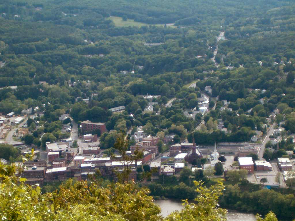
Brattleboro, Vermont — Town — View of downtown Brattleboro from Mount Wantastiquet in New Hampshire Location in Vermont
Coordinates: 42°51′0″N 72°34′56″W / 42.85°N 72.58222°WCoordinates: 42°51′0″N 72°34′56″W / 42.85°N 72.58222°W Country United States State Vermont County Windham Chartered 1753 Area – Total 32.4 sq mi (84.0 km2) – Land 32.0 sq mi (82.9 km2) – Water 0.5 sq mi (1.2 km2) Elevation 633 ft (193 m) Population (2010) – Total 12,046 – Density 375.3/sq mi (144.9/km2) Time zone Eastern (EST) (UTC-5) – Summer (DST) EDT (UTC-4) ZIP codes 05301-05304 Area code(s) 802 FIPS code 50-07900[1] GNIS feature ID 1462049[2] Website brattleboro.org Brattleboro, originally Brattleborough,[3] is a town in Windham County, Vermont, United States, located in the southeast corner of the state, along the state line with New Hampshire. The population was 12,046 at the 2010 census. It is situated along the Connecticut River, at the mouth of the West River.[4]
Brattleboro is the oldest town in the state, and noted for its vibrant arts community, as well as the renowned Brattleboro Retreat, a psychiatric hospital and convalescent center.
Contents
History
Abenaki Land
Once known as Wantastiquet, the area now known as Brattleboro lies at the confluence of the West River and the Connecticut River. The West River was called Wantastiquet in the Abenaki language, a word meaning 'river which leads to the west', and is marked by Mount Wantastiquet at its mouth and the Wantastiquet Ponds at its source. The Abenaki would transit this area annually between Missisquoi, their summer hunting grounds in northwestern Vermont, and Squakheag, their winter settlements near what is now Northfield, Massachusetts. The band of Abenaki who frequented this area were called Sokoki, which means 'people who go their own way' or 'people of the lonely way'. The Abenaki vigorously defended their land 'Ndakinna' against European settlement in the 17th and 18th centuries, including during Gray Lock's War, also known as Dummer's War. When most Abenaki sided with the French in the mid-1700s, many or most of them were driven north into Quebec, opening the way for untrammeled English, and later United States, settlements northward into what is now Vermont.
Frontier fort
 Bird's-eye view in 1905
To defend Massachusetts during the French and Indian Wars, the General Court voted on December 27, 1723 to build a blockhouse and stockade at what would become Brattleboro. Lieutenant-governor William Dummer signed the measure, so construction of Fort Dummer began on February 3, 1724 and was completed before summer. On October 11, the French attacked the fort and killed some soldiers, but left before reinforcements could arrive.[5]
In 1725, Dummer's War ended, so in 1728 the fort was converted into a trading post for lucrative commerce with friendly Indians. But in 1744, King George's War broke out and lasted until 1748. Massachusetts kept a small body of troops at the fort until 1750, after which it was considered unnecessary. The township became one of the New Hampshire grants, chartered on December 26, 1753 by Governor Benning Wentworth and named Brattleborough after Colonel William Brattle, Jr. of Boston, a principal proprietor. Settlement was tentative until after the 1763 Treaty of Paris, when France abandoned New France.[5]
With hostilities ceased, Brattleboro developed quickly, and soon was second to none in the state for business and wealth. In 1771, Stephen Greenleaf opened Vermont's first store in the east village, and in 1784, a post office was established. A bridge was built across the Connecticut River to Hinsdale, New Hampshire in 1804.[6] In 1834, the Brattleboro Retreat for the mentally ill was founded by bequest of Anna Marsh. The postmaster issued the first postal stamps in the United States in 1846, two years after the Brattleboro Hydropathic Establishment was opened by Dr. Robert Wesselboeft in 1843-1844. This was the third water cure establishment in the country. Pure spring water was discovered near Whetstone Brook, and until "The Water Cure" closed in 1871, the town was a curative health resort.[3][7][8]
Mill town
 Whetstone Falls in 1907
Whetstone Falls provided water power for watermills, beginning with a sawmill and gristmill. By 1859, when the population had reached 3,816, Brattleboro had a woolen textile mill, a paper mill, a manufacturer of papermaking machinery, a factory making melodeons, two machine shops, a flour mill, a carriage factory, and four printing establishments.[5] Connected by the Vermont & Massachusetts Railroad and the Vermont Valley Railroad, the town prospered from the trade of grain, lumber, turpentine, tallow and pork.[9] In 1888, postal authorities decided that all towns ending in borough should be shortened to boro, and Vermont complied. The first person ever to receive a Social Security benefit check, issued on January 31, 1940 was Ida May Fuller from Brattleboro. Her check number was 00-000-001 and it was for $22.54.[10]
Public nudity
Public nudity, although not always welcomed by the denizens of the town, was not forbidden by any Vermont statute or Brattleboro ordinance until July 17, 2007. The town had drawn national attention when nudists made a visit to take advantage of the situation.[11][12] On July 17, 2007, Brattleboro town officials passed an emergency rule by a 3–2 margin, temporarily "banning nudity on the main roads and within 250 feet of any school or place of worship, among other places" due to a number of complaints.[13][14] On August 22, 2007, the Brattleboro Selectboard decided not to make the ban on nudity permanent, once again allowing nudity in the town when the temporary statute ran out in September. On December 4, 2007 the ban was made permanent, however.[15] , [16]
Petition against Bush and Cheney
 Main Street Bridge over Whetstone Brook
 United States Navy Seabees Bridge over the Connecticut River
On January 25, 2008, the town council by a 3-2 vote approved a petition to be placed on a March 4 ballot, calling for the indictment of President George W. Bush and Vice President Dick Cheney for crimes against the United States Constitution. The petition reads: "Shall the Selectboard instruct the Town Attorney to draft indictments against President Bush and Vice President Cheney for crimes against our Constitution, and publish said indictments for consideration by other authorities and shall it be the law of the Town of Brattleboro that the Brattleboro Police, pursuant to the above-mentioned indictments, arrest and detain George Bush and Richard Cheney in Brattleboro if they are not duly impeached, and prosecute or extradite them to other authorities that may reasonably contend to prosecute them?"[17]
The town council issued a statement on the petition, which the town voted on as a town meeting article on March 4, and passed.[18]
“ On January 25 the Town Clerk's office received a petition from Brattleboro resident Kurt Daims. Per Town Charter, a petition containing signatures from 5% of Brattleboro voters can be placed on the ballot for a Town-wide vote. Mr. Daims' petition did contain the required number of signatures. At a meeting on January 25, the Brattleboro Selectboard voted 3-2 to place the petition on the ballot. Reasons given by Board members voting in the affirmative centered on the belief that if a petition contained the required signatures, the voters should have the opportunity to vote on the matter. Reasons given by Board members voting on the dissent centered on the belief that articles outside the scope and authority of the Town should not go before the voters of the Town. The Brattleboro Town Attorney has stated that the petition has no legal standing, as the Town Attorney has no authority to write an indictment and the Town Police Department has no authority to attempt an arrest of the President of the United States. ” Geography
 Brattleboro landscape
Brattleboro is located at 42°51′15″N 72°33′31″W / 42.85417°N 72.55861°W. Due to its location in the southernmost part of Vermont, the town is actually geographically closer to the state capitals of Albany, Hartford, Boston, and Concord than to its own state capital, Montpelier.
According to the United States Census Bureau, the town has a total area of 32.5 square miles (84.0 km2), of which 32.0 square miles (82.9 km2) is land and 0.5 square mile (1.2 km2, 1.42%) is water. Brattleboro is drained by the West River, Ames Hill Brook and Whetstone Brook. The town is in the Connecticut River Valley; the eastern boundary (and Vermont state line) is the western bank of the Connecticut River. Hills and mountains surround the town.
Brattleboro is crossed by
 Interstate 91,
  U.S. Route 5,
  Vermont Route 9 and
  Vermont Route 30.
Development
Brattleboro, being the first major town from the Massachusetts border on Interstate 91, offers a mix of a rural atmosphere and urban amenities such as a large number of hotels. Brattleboro is a host to a number of art galleries and stores.
In 2007, Brattleboro passed a resolution designating itself a Fair Trade Town, becoming the second Fairtrade certified town in the nation after Media, Pennsylvania.
The town's densely populated center is at the very bottom of the Connecticut river valley. Because of the area's hilly terrain, and relatively little flat land, many buildings are on steep grades, closely bunched together; the topography has helped to create an semi-urban atmosphere.
Since the 1950s, there was suburban development outside of the traditional downtown in the west, south, and north of the township. The southern section of the town is predominantly one or two family houses with a mix of triple deckers. Commercial and industrial operations are concentrated on the U.S. Route 5/Canal Street artery that cuts through the area. The town's high school and the Regional Career Center are located in this section.
The western section of town, which formally became a village in 2005, is mostly residential, with the state's largest mobile home park and several large planned developments.
The northern section of Brattleboro developed in the 1960s and 1970s. The area has little residential development and is dominated by large commercial and industrial establishments along Putney Road, including about seven hotels located within a short distance of each other. C&S Wholesale Grocers made its headquarters here until moving them to Keene, New Hampshire in 2005; however, because of close proximity to Interstate 91, C&S has kept large shipping and warehouse operations in Brattleboro.
The outskirts of Brattleboro have a decidedly rural feel, with little housing development and boasting the last farms left in Brattleboro after the collapse of the dairy industry in the 1970s. At its peak, the area had over 170 farms; there are now only nine left.[citation needed] Brattleboro is also the headquarters of the Holstein Association.
Demographics
Historical populations Census Pop. %± 1840 2,624 — 1850 3,816 45.4% 1860 3,855 1.0% 1870 4,933 28.0% 1880 5,880 19.2% 1890 6,862 16.7% 1900 6,640 −3.2% 1910 7,541 13.6% 1920 8,332 10.5% 1930 9,816 17.8% 1940 10,983 11.9% 1950 11,522 4.9% 1960 11,734 1.8% 1970 12,239 4.3% 1980 11,886 −2.9% 1990 12,241 3.0% 2000 12,005 −1.9% 2010 12,046 0.3%  Downtown Brattleboro, as seen across the Connecticut River, from New Hampshire
As of the census[1] of 2000, there were 12,005 people, 5,364 households, and 2,880 families residing in the town. Almost all of the population is concentrated in two census-designated places identified in the town: Brattleboro and West Brattleboro.
The population density of the town was 375.3 people per square mile (144.9/km2). There were 5,686 housing units at an average density of 177.7 per square mile (68.6/km2). The racial makeup of the town was 94.06% White, 1.13% Black or African American, 0.26% Native American, 1.67% Asian, 0.04% Pacific Islander, 0.55% from other races, and 2.28% from two or more races. Hispanic or Latino of any race were 1.67% of the population.
There were 5,364 households out of which 27.2% had children under the age of 18 living with them, 37.8% were married couples living together, 12.8% had a female householder with no husband present, and 46.3% were non-families. 37.8% of all households were made up of individuals and 13.3% had someone living alone who was 65 years of age or older. The average household size was 2.15 and the average family size was 2.84.
In the town the population was spread out with 22.3% under the age of 18, 6.6% from 18 to 24, 29.2% from 25 to 44, 25.3% from 45 to 64, and 16.6% who were 65 years of age or older. The median age was 40 years. For every 100 females there were 84.0 males. For every 100 females age 18 and over, there were 79.9 males.
The median income for a household in the town was $31,997, and the median income for a family was $44,267. Males had a median income of $31,001 versus $25,329 for females. The per capita income for the town was $19,554. About 9.2% of families and 13.1% of the population were below the poverty line, including 18.0% of those under age 18 and 9.2% of those age 65 or over.
Government
Brattleboro employs a Representative Town Meeting local government, wherein its citizens are represented at-large by a Select Board of five members, and by several dozen Town Representatives elected from three municipal districts. The Select Board is considered the 'executive branch' of town government; its five members are elected to fill three one-year positions and two three-year positions. In turn, the Select Board hires and supervises a Town Manager.[19] The town's three districts also each elect a representative to the Vermont State Legislature.
Transportation
 Amtrak train in Brattleboro
Rail
See also: Brattleboro (Amtrak station)Amtrak, the national passenger rail system, operates its Vermonter service daily through Brattleboro, between Washington, D.C. and St. Albans, Vermont.
Bus
The Brattleboro BeeLine operates throughout the town between 6:00 a.m. and 6:30 p.m., and is composed of the Red Line and Blue Line buses, which work in conjunction with each other to move residents throughout the T shaped street map of the town. Bus services, including the Current and the Moover, also run daily between Brattleboro and Bellows Falls, between Brattleboro and Whitingham, and along Vermont Route 30 to the northwest. In addition, Brattleboro is serviced daily by the national bus service Greyhound, which stops at a franchised terminal on Route 5.
Highway
Brattleboro is served by three highways and one Interstate route. Vermont Route 9 runs from the New York border with Vermont, west of Bennington, traveling east through downtown Brattleboro, then running north to the New Hampshire border. Route 9's local names within Brattleboro include Molly Stark Trail, Marlboro Road, Western Avenue, High Street, Main Street, and Putney Road. Route 9 runs concurrently with U.S. Route 5 from the intersection of Main and High Streets north to meet Interstate 91 Exit 3.
U.S. Route 5 enters Brattleboro at its border with the town of Guilford and runs northerly, through downtown, and eventually exits Brattleboro at its border with Dummerston, Vermont. Route 5's local names are as follows (from beginning to end in Brattleboro) Canal Street, Main Street, Putney Road. Southbound, Route 5 also runs along Park Place and a part of Linden Street, following a one-way triangle at the north end of Main Street.
Vermont Route 30, considered one of the most scenic roads in Vermont, runs to the northwest along the southern bank of the West River. It has its southern terminus in Brattleboro at the intersection of Park Place and Linden Street, and exits Brattleboro at its border with Dummerston. Route 30's local names within Brattleboro are Linden Street and West River Road.
Interstate 91, originating in Connecticut and terminating at the Canadian border, runs through town in a semi-circumferential north-south manner around the town center. Exit one serves the southern part of town; exit two serves the western section of town connecting to local ski areas via Route 9; exit three serves the northern section of town and New Hampshire.
Culture
Print media
The town is home to the Brattleboro Reformer, a daily newspaper with a circulation of about 11,000, and the Commons, a nonprofit community weekly newspaper with a circulation of 5,900.[20] The Parent Express, a community newspaper circulates in Brattleboro, Keene, New Hampshire, and throughout Windham County, Vermont and Cheshire County, New Hampshire.[21]
Online media
Brattleboro has one of the country's oldest citizen journalism web sites, iBrattleboro.com, providing local news and information written by residents.[citation needed]
Radio
There are several radio stations which broadcast in Brattleboro.
FM
- WKVT-FM 92.7.[22]
- WRSI 101.5 (repeater station at Marlboro, Vermont of station broadcasting from Deerfield, Massachusetts on 93.9, with studios in Northampton, Massachusetts).[23][24]
- WTSA-FM 96.7.[25]
- WVEW-LP 107.7 (community-supported low power station).[26]
AM
Arts and events
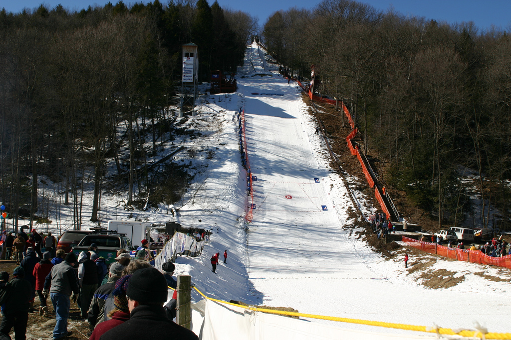
 Harris Hill, ski jumping venue
 A contestant airborne
Brattleboro has a thriving arts community. The town is listed in John Villani's book The 100 Best Small Art Towns in America, in which it ranks number nine among towns with a population of 30,000 or under.[citation needed]
On the first Friday of every month, an event known as the Gallery Walk[27] is held, in which galleries, artists, and arts organizations open their doors to the public to display new work or hold performances. Included in the organizations that participate are the Brattleboro Museum and Art Center,[28] the Hooker-Dunham Theater and Gallery,[29] the In-Sight Photography Project,[30] River Gallery School,[31] Through the Music,[32] and the Windham Art Gallery.[33]
Other notable arts organizations in Brattleboro include the Brattleboro Music Center,[34] the Vermont Theatre Company,[35] the New England Youth Theater,[36] the Brattleboro Women's Chorus,[37] the Brattleboro School of Dance,[38] Luminz Studio dance and performing arts center,[39] and the New England Center for Circus Arts (NECCA).[40]
Annual events in Brattleboro include:
- The Winter Carnival in February.[41]
- Harris Hill ski-jumping competition in February.[42]
- Women's Film Festival in March. http://www.womensfilmfestival.org/[43]
- Easter Egg Hunt in April (for residents only).
- Maple Open House Weekend in March.[44]
- River Gallery School benefit auction in March.[45]
- Taste of the Town in May.[46]
- Strolling of the Heifers the first weekend in June.[47]
- Brattleboro Fest music festival in mid-June.[citation needed]
- Vermont Theatre Company's Shakespeare-in-the-Park in June and July.[48]
- Brattleboro Animation Festival on the first Friday in July.[citation needed]
- Brattleboro Free Folk Festival, begun in 2003.[citation needed]
- Brattleboro Literary Festival in September.[49]
- World Solstice Celebration in December.[citation needed]
Literary
Brattleboro has an important literary history. Brattleboro's first bookstore opened in 1795. The first Bible to be printed in Vermont was printed in the town, in 1812.[citation needed] The Brattleboro Literary Festival has been held every fall since 2001.[citation needed] Brattleboro was the site of the first U.S. printing of the first Harry Potter book. For several years, Brattleboro was also the home of the world-famous writer Rudyard Kipling, who married a young woman from the Town and built a home called Naulakha on its northern border with the Town of Dummerston.
Cultural references
- Brattleboro is the setting for much of H. P. Lovecraft's story The Whisperer in Darkness.[citation needed]
- Brattleboro is mentioned repeatedly in David Foster Wallace's novel Infinite Jest.[50]
- The popular Joe Gunther mystery series written by Archer Mayor is largely set in Brattleboro.[citation needed]
- Brattleboro is where the title character in Tom Taylor's play Our American Cousin meets his English relatives, leading to his trip to England where the events of the play take place.[citation needed]
- In the comedy movie Super Troopers, Lieutenant Arcot "Thorny" Ramathorn suggests that Brattleboro would be a good town to move to since his station is going to be shut down.
- The psychiatric hospital in the 2011 action movie Sucker Punch is located in Brattleboro.
Sites of interest
- Brattleboro Historical Society & Museum
- Brattleboro Museum & Art Center
- Fort Dummer State Park
- Hooker-Dunham Theater & Gallery
- New England Youth Theatre
- Vermont Theatre Company
- New England Center for Circus Arts (NECCA)
- Strolling of the Heifers
See also
- List of people from Brattleboro, Vermont
- Marlboro College Graduate School
- School for International Training
- Union Institute & University
References
- ^ a b "American FactFinder". United States Census Bureau. http://factfinder.census.gov. Retrieved 2008-01-31.
- ^ "US Board on Geographic Names". United States Geological Survey. 2007-10-25. http://geonames.usgs.gov. Retrieved 2008-01-31.
- ^ a b Virtual Vermont -- Brattleboro
- ^ DeLorme (1996). Vermont Atlas & Gazetteer. Yarmouth, Maine: DeLorme. ISBN 0-89933-016-9.
- ^ a b c A. J. Coolidge & J. B. Mansfield, A History and Description of New England; Boston, Massachusetts 1859
- ^ Brattleboro in 1824
- ^ Nichols, Mary S. Gove (1855). "Experience in the Water Cure: A familiar exposition of the Principles and Results of Water Treatment, in the Cure of Acute and Chronic Diseases". in Fowlers and Wells' Water-Cure Library: Embracing all the most popular works on the subject. Vol. 2 of 7. New York: Fowlers and Wells. p. 30 (n85 in electronic page field). http://www.archive.org/stream/anintroductiont01nichgoog#page/n56/mode/1up. Retrieved 2009-10-29. Full text at Internet Archive (archive.org).
- ^ Cabot, Mary R. (Ed.) (1922). The Annals of Brattleboro 1681-1895. Vol. 2 of 2. Brattleboro, Vermont: E.L. Hildreth & Co.. http://www.archive.org/details/annalsbrattlebo01cabogoog. Retrieved 14 December 2009. Full text at Internet Archive (archive.org).
- ^ Hayward's New England Gazetteer of 1839
- ^ Social Security Online. "The First Social Security Beneficiary". Social Security Administration. http://www.ssa.gov/history/imf.html. Retrieved June 28, 2007.
- ^ Associated Press (May 17, 2007). "Spring Thaw Brings Out Nudity in Small Vermont Town". Fox News. http://www.foxnews.com/story/0,2933,273216,00.html. Retrieved May 17, 2007.
- ^ Daily Telegraph newspaper, pp.15, 07-16-07.
- ^ Reuters (July 18, 2007). "Vermont town bans public nudity after brash displays". Reuters. http://www.reuters.com/article/domesticNews/idUSN1823185120070718?feedType=RSS&rpc=22&sp=true. Retrieved 2007-07-18.
- ^ Bob Audette. "Cover up: Anti-nudity rule passes". Brattleboro Reformer. http://www.reformer.com/headlines/ci_6401076. Retrieved 2007-07-18.
- ^ Associated Press. "Go Ahead, Drop Those Drawers". http://customwire.ap.org/dynamic/stories/O/ODD_NAKED_TOWN?SITE=MABOC&SECTION=HOME&TEMPLATE=DEFAULT. Retrieved 22 August 2007.
- ^ 2007 Year in Review [1] - Brattleboro Reformer
- ^ Vermont Anti-Bush Petition Sparks Anger, Associated Press, January 30, 2008.
- ^ Reuters (March 5, 2008). "Vermont Towns vote to arrest Bush and Cheney". http://www.reuters.com/article/oddlyEnoughNews/idUSN0551104720080305?feedType=RSS&feedName=oddlyEnoughNews&rpc=92&sp=true. Retrieved March 6, 2008.
- ^ Brattleboro Town Charter. "Town Charter". http://www.brattleboro.org. Retrieved June 29, 2007.
- ^ [1]
- ^ Parent Express
- ^ a b WKVT radio station.
- ^ Radio-Locator database.
- ^ WRSI radio station.
- ^ a b WTSA radio station.
- ^ WVEW radio station.
- ^ Gallery Walk, Brattleboro, Vermont - a Monthly First-Friday Celebration!
- ^ Brattleboro Museum & Art Center » home
- ^ Hooker-Dunham Theater - Great Stuff's Happening!
- ^ http://www.insight-photography.org
- ^ http://rivergalleryschool.org
- ^ Welcome to Through the Music
- ^ Windham Art Gallery - May, 2008
- ^ Brattleboro Music Center - Music School, Summer Music Camps, Chamber Music, Music For Hire, Southeastern Vermont
- ^ Vermont Theatre Company - Home
- ^ New England Youth Theater
- ^ Brattleboro Women's Chorus
- ^ School of Dance
- ^ [2]
- ^ New England Center for Circus Arts (NECCA)
- ^ [3]
- ^ Harris Hill Ski Jump
- ^ Women's Film Festival 2008 - Home
- ^ Annual Maple Open House Weekend - Vermont Maple Sugar Makers' Association & Vermont Maple Foundation
- ^ Benefit Auction at the Brattleboro Museum and Art Center
- ^ The Winston Prouty Center for Child Development
- ^ Strolling of the Heifers: Friday, June 4 – Sunday, June 6, 2010
- ^ Vermont Theatre Company - Home
- ^ Welcome to the 2007 Brattleboro Literary Festival
- ^ Infinite Jest, pp. 901: "C.T. was the infant son she'd brought to the new union, his father a ne'er-do-well killed in a freak accident playing competitive darts in a Brattleboro tavern just as they were trying to adjust the obstetric stirrups for the achondroplastic Mrs. Tavis's labor and delivery."
Further reading
- Cabot, Mary R. (Ed.) (1922). The Annals of Battleboro 1681-1895. Vol. 2 of 2. Battleboro, Vermont: E.L. Hildreth & Co.. http://www.archive.org/details/annalsbrattlebo01cabogoog. Retrieved 14 December 2009.
External links
- Brattleboro, Vermont at the Open Directory Project
- Brattleboro Area Chamber of Commerce
- Brattleboro Historical Society
Municipalities and communities of Windham County, Vermont Towns Athens | Brattleboro | Brookline | Dover | Dummerston | Grafton | Guilford | Halifax | Jamaica | Londonderry | Marlboro | Newfane | Putney | Rockingham | Somerset‡ | Stratton | Townshend | Vernon | Wardsboro | Westminster | Whitingham | Wilmington | Windham

Villages CDPs Other
communitiesFootnotes ‡ Disincorporated
Categories:- Towns in Vermont
- Brattleboro, Vermont
- Populated places on the Connecticut River
- Populated places in Windham County, Vermont


Wikimedia Foundation. 2010.