- Wilbraham, Massachusetts
-
Wilbraham, Massachusetts — Town — Wilbraham Center Location in Hampden County in Massachusetts
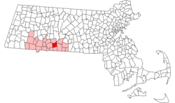
Coordinates: 42°07′25″N 72°25′55″W / 42.12361°N 72.43194°WCoordinates: 42°07′25″N 72°25′55″W / 42.12361°N 72.43194°W Country United States State Massachusetts County Hampden Settled 1730 Incorporated 1763 Government – Type Open town meeting Area – Total 22.4 sq mi (58.1 km2) – Land 22.2 sq mi (57.5 km2) – Water 0.2 sq mi (0.5 km2) Elevation 290 ft (88 m) Population (2010) – Total 14,868 – Density 640.5/sq mi (247.3/km2) Time zone Eastern (UTC-5) – Summer (DST) Eastern (UTC-4) ZIP code 01095 Area code(s) 413 FIPS code 25-79740 GNIS feature ID 0619390 Website http://www.wilbraham-ma.gov/ Wilbraham is a town in Hampden County, Massachusetts, United States. It is also a suburb of the City of Springfield, Massachusetts and part of the Springfield Metropolitan Statistical Area. The population was 14,868 at the 2010 census. Wilbraham is bordered by the City of Springfield to the west, Town of Ludlow to the north, Towns of Palmer and Monson to the east, Town of Hampden to the South and the Town of East Longmeadow to the southwest.
Wilbraham was originally divided between North Wilbraham and Wilbraham. North Wilbraham was home to the industrial side of the town along with the Boston & Albany Railroad Line which is still in use today. Wilbraham was home to the farms and the Wilbraham & Monson Academy. At one time North Wilbraham even had its own zip code which was 01067. However the term North Wilbraham is now rarely used by town residents and has been replaced by just Wilbraham.
Part of the town comprises the census-designated place of Wilbraham.
In 1928, author H. P. Lovecraft visited Wilbraham, after which he modeled the fictional town of Dunwich in his story The Dunwich Horror.
Contents
History
Wilbraham was first settled in 1730 by Nathaniel Hitchcock along with what is now Hampden, Massachusetts as the Fourth District of Springfield. It was also known as the Outward Commons, Mountains or Springfield Mountain. Hitchcock built a log hut along what is now Main St. Hunting and logging occurred in the late 17th century. The town was officially incorporated as the independent "Wilbraham" in 1763, when its population was about 400. Wilbraham was made a separate town because the nearest church was located in Springfield and due to the long walk it was decided that Wilbraham would become its own town with its own church. Its first church was the First Congregational Church which was organized on June 24, 1741. This church would later merge into the Wilbraham United Church. The first minister of the town was Mr. Noah Merrick. The first three selectmen were Lieutenant Thomas Mirick, Deacon Nathaniel Warriner and Stephen Stebbins.[1][2]
The Native Americans did not maintain any villages prior to the colonials' arrival in the Outward Commons; however, they did hunt and fish along the Chicopee River as it was and still is considered good fishing grounds. A soap stone quarry existed on Glendale Road and arrowheads can be found throughout Wilbraham. The poplar trees located along the Chicopee River made excellent canoes, and a couple have been found carved out along the Chicopee River over the years. In fact the Native Americans referred to this area as "Minnechaug" which means Berryland.
Wilbraham is situated in such a way that its area lies within two broad physiographic provinces that cross Massachusetts from north to south. The Wilbraham Mountains which dominate the geography of the town are part of the Central Upland of Massachusetts, while the portion of town west of the mountains lies within the Connecticut Valley Lowland. In fact millions of years ago the flat area of Wilbraham west of the mountains were once part of a shallow inland sea.
Many town residents took part in both the French and Indian War and Revolutionary War and at one time Wilbraham even had its own militia which happened at one point to be a Field Artillery Battery which much of the time supported the Hampshire Regiment. It is important to note that the main regiment that Wilbraham residents were usually assigned to was the Hampshire Regiment which happened to be established in the City of Springfield on May 14, 1639. Wilbraham residents have also served in the War of 1812, American Civil War, Spanish-American War, World War I, World War II, Korean War, Vietnam War, Desert Storm, Kosovo as well as in Iraq and Afghanistan in the 21st century.
The Wilbraham town center is among the largest designated historical areas in the country, with fine examples of colonial and Victorian homes from as early as the 1730s along the historical areas of main street. The oldest Methodist meeting house in New England is located in the town's center, as is the campus of Wilbraham & Monson Academy, founded in 1804.
In 1878, the south end of Wilbraham officially broke away from Wilbraham and formed the Town of Hampden.
Wilbraham is made up of several neighborhoods called Wilbraham Center, North Wilbraham, East Wilbraham, Wilbraham Mountain, South Wilbraham, Boston Rd Corridor and the Pines Section.
North Wilbraham was the industrialized area of the town and was home to the Collins Manufacturing Company and other businesses. The Collins Manufacturing Company was once the main employer of the town. The building also known as the Collins Paper Mill (which still stands today) was located was built around 1872. It made fine writing paper and, for a short time, it made government currency paper. The mill officially closed down in 1940 but some part continued operating into the 1950s. A fire in 1945 did severe damage to the building. The building now stands vacant.
Wilbraham Center was the farming area of town and was home to Bennett's Turkey Farm, Pheasant Farm and Rice's Fruit Farm which grew the peaches later celebrated during the Peach Festival. Wilbraham had several potato farms in the south end of town around the time of World War II. Sadly, none of those farms, as well as many others once located in town, are in operation today.
Wilbraham is also the home of Friendly's. Although this restaurant and ice cream corporation was started in Springfield, Massachusetts, it is currently headquartered in Wilbraham. On the Massachusetts Turnpike, hedges along the side of the "Pike" have been trimmed to welcome drivers to "Wilbraham, home of Friendly's Ice Cream."
On August 7, 1761 on Wilbraham Mountain a young man named Timothy Merrick was bitten by a rattlesnake. He died soon afterward. Folklore and legend has made its way over the years about this incident including a song titled "On Springfield Mountain". In fact many say that the incident did not occur in Wilbraham, but rather in Hampden, MA, or possibly Connecticut. This song was one of the earliest of the American ballads.
On April 29, 1799 a tragedy on Nine Mile Pond took the lives of six people, including three 16 year old girls. The boat that they were traveling in overturned. One of the victims was not found for sixteen days and a ditch had to be dug in order to drain the pond to find her. This ditch located across the street on Boston Rd became the first town dump. Today it is open space but only certain back sections can be built upon due to the instability from the trash and other things collected there over the years.
The Bay Path trail once ran through the north end of the town. It was this trail that Henry Knox used when he moved the cannons that he captured at Fort Ticonderoga in 1775. These cannons were brought to Boston (being pulled by oxen) and placed on Dorchester Heights and used against the British. Knox led the artillery train through the town.
The first President of the United States, General George Washington, traveled through the town and slept at a home along the Bay Path in 1790 while on his way to Boston.
The Underground Railroad ran through the town and several houses along Main St and on Wilbraham Mountain had hiding places.
During World War I the town suffered the loss of five soldiers who were killed while fighting overseas. They were George M. Kingdon, Clarence E. Green, Nelson Vincent, Edward F. Powers and John Wojnick.
The Hurricane of 1938 did considerable damage to the town and destroyed the old covered bridge over the Chicopee River on Cottage Ave. A steel bridge rests there today.
Wilbraham was once of the home of a speakeasy called "Worlds End" on Burleigh Rd. It was destroyed by a fire in the mid 1930's.
The Flood of 1955 washed out many of the roads in the town. The dam near the Chicopee River gave way washing out the railroad tracks and parts of Mountain Rd and Boston Rd.
Wilbraham once had a drive in movie theatre called Parkway. It was located on Boston Rd where the Home Depot is now located.
Wilbraham was once the home of Bowling Alley called 10-Pin Bowling Alley. It was a very popular place in town. There were weekly leagues and a lot of people from the town used to hang out there on Friday and Saturday nights. Big Y Supermarket is now located in its spot which opened in June of 2008
Wilbraham has both a Fire Department and Police Department. The Fire Department was formed in 1919 as the George M. Kingdon Fire Company. The fire company was named in honor of Mr. Kingdon as he was one of the Wilbraham residents who was killed in France during World War I. The Wilbraham Fire Department was originally a volunteer force and had 32 members. The first Fire Chief was Andrew D. Macauley and the Assistant Chief was Augustus F. "Gus" Friend who also happened to be one of the town constables and was known by many for breaking up brawls no matter its size and his only weapons were his fists. It has recently been found that a Hook & Ladder truck most likely utilized to protect the students at the Wilbraham & Monson Academy existed in Wilbraham Center in the mid-19th century. The barn burned in the Fire of 1877 which destroyed much of the center of town. The department once had two brothers who served as Fire Chief, the first being Paul E. Tupper in the 1930s and Ralph E. Tupper from 1943 to 1965. Today the Fire Department is a full time force with two fire stations, one is located in North Wilbraham (Fire Headquarters) and the other one is located in Wilbraham Center. The Police Department was formed in 1954 to assist the State Police in patrolling and responding to emergencies in the town during certain night hours. Today it has over twenty full time officers and a K-9 unit. Its first police chief was William Pollitt.
Wilbraham has a Board of Selectmen. They each serve for a two year term. The town has an open town meeting rule rule and an annual town meeting is held every spring.
In 1995 the Stanley Cup which is won every year by a National Hockey League team came to town after New Jersey Devils player and Wilbraham native Bill Guerin helped win the award. The cup was present at the Wilbraham & Monson Academy and Guerin and the cup were the main attraction at the 1995 Peach Festival Parade.
The Peach Festival has been held every year since 1984 in middle August. It was held originally at the High School but now is held at the Pheasant Farm. A pancake breakfast occurs on Sunday morning along with a Road Race. A fireworks show occurs that Saturday night. For every Peach Festival a Peach Queen and her court has been selected along with a Peach King.
Wilbraham has a centrally located Library and a Regional School District called the Hampden-Wilbraham Regional School District. There is a Grange Hall in the town but it is no longer used.
Wilbraham also has the beautiful Wilbraham Mountain Range which starts at the north end of town and goes all the way down into Hampden. The highest point in town is Mt. Chapin at 937 feet above sea level.
Wilbraham at one time was very famous for its peach orchards and some are still grown on the slope of the Wilbraham Mountain Range. Apples were also grown on the slopes and Rices Fruit Farm which used to own a store which unfortunately closed in 2008 used to sell fresh apples, apple cider, apple pies and other delicious items.
Wilbraham will be celebrating its 250th anniversary in 2013. Lots of fun activities are being planned to be staged throughout the year by the 250th anniversary committee.
The name of Wilbraham comes from the villages of Little Wilbraham and Great Wilbraham located near Cambridge, England. Those two villages came into existence because Alfred the Great, an English King who upon hunting wild boar in a very good spot about 60 miles northeast of London, designated that spot as Wild Boar Haven. However Haven was later changed to Ham and over the years the three separate words became combined and distorted until you had Wilbraham. However it is said that the name Wilbraham may have also came from Sir Thomas Wilbraham a bitter royalist and anti-Puritan.[citation needed]
On the afternoon of June 1, 2011 two tornados struck Wilbraham an EF-1 and an EF-3. The EF-3 which originated in Westfield and traveled through West Springfield and Springfield caused extensive damage to the Tinkham Road corridor of the town. Heavy structural damage to homes, power poles, and trees was experienced. That tornado then moved eastward to cause more extensive damage to the towns of Monson, Brimfield, and Sturbridge. The EF-1 formed after the EF-3 and primarily caused damage to power poles and trees along a section from Stony Hill Rd east crossing Main St. just south of St. Cecilias Church to Crane Hill Rd.
Geography

Springfield Ludlow Palmer Springfield 
Monson  Wilbraham, Massachusetts

East Longmeadow Hampden Monson According to the United States Census Bureau, the town has a total area of 22.4 square miles (58.1 km²), of which, 22.2 square miles (57.5 km²) of it is land and 0.2 square miles (0.5 km²) of it (0.89%) is water. Wilbraham is bordered by Springfield on the west, Ludlow on the north, Palmer on the northeast, Monson on the east, Hampden on the south, and East Longmeadow on the southwest.
Demographics
Historical populations Year Pop. ±% 1850 2,127 — 1860 2,081 −2.2% 1870 2,330 +12.0% 1880 1,628 −30.1% 1890 1,814 +11.4% 1900 1,595 −12.1% 1910 2,332 +46.2% 1920 2,780 +19.2% 1930 2,719 −2.2% 1940 3,041 +11.8% 1950 4,003 +31.6% 1960 7,387 +84.5% 1970 11,984 +62.2% 1980 12,053 +0.6% 1990 12,635 +4.8% 2000 13,473 +6.6% 2010 14,868 +10.4% As of the census[3] of 2000, there were 13,473 people, 4,891 households, and 3,873 families residing in the town. The population density was 606.3 people per square mile (234.1/km²). There were 5,048 housing units at an average density of 227.2 per square mile (87.7/km²). The racial makeup of the town was 96.40% White, 1.19% Black or African American, 0.06% Native American, 1.26% Asian, 0.06% Pacific Islander, 0.25% from other races, and 0.77% from two or more races. Hispanic or Latino of any race were 1.40% of the population.
There were 4,891 households out of which 37.2% had children under the age of 18 living with them, 68.7% were married couples living together, 8.0% had a female householder with no husband present, and 20.8% were non-families. 17.9% of all households were made up of individuals and 10.4% had someone living alone who was 65 years of age or older. The average household size was 2.71 and the average family size was 3.09.
In the town the population was spread out with 26.9% under the age of 18, 4.3% from 18 to 24, 24.4% from 25 to 44, 27.6% from 45 to 64, and 16.9% who were 65 years of age or older. The median age was 42 years. For every 100 females there were 92.5 males. For every 100 females age 18 and over, there were 88.3 males.
The median income for a household in the town was $65,014, and the median income for a family was $73,825. Males had a median income of $55,600 versus $36,922 for females. The per capita income for the town was $29,854. About 3.2% of families and 5.1% of the population were below the poverty line, including 5.5% of those under age 18 and 9.0% of those age 65 or over.
Library
The Wilbraham Free Public Library was established in 1892.[4][5] In fiscal year 2008, the town of Wilbraham spent 2.32% ($677,591) of its budget on its public library—some $48 per person.[6]
Notable residents
- Former NHL player and US Olympian Bill Guerin
- NASCAR driver Erin Crocker.
- Birthplace of American novelist, Raymond Kennedy
- Former Major League Baseball Pitcher Mike Trombley
- Edith Miniter (1867–1934), author of Our Natupski Neighbors
- NASCAR Modified Racer Mike Stefanik
References
- ^ A Brief History of Wilbraham, from Wilbraham Bicentennial program, 1963
- ^ http://www.wilbraham-ma.gov/index.cfm?fuseaction=category.display&category_id=134
- ^ "American FactFinder". United States Census Bureau. http://factfinder.census.gov. Retrieved 2008-01-31.
- ^ Report of the Free Public Library Commission of Massachusetts. v.9 (1899)
- ^ http://www.wilbrahamlibrary.org/ Retrieved 2010-11-09
- ^ July 1, 2007 through June 30, 2008; cf. The FY2008 Municipal Pie: What’s Your Share? Commonwealth of Massachusetts, Board of Library Commissioners. Boston: 2009. Available: Municipal Pie Reports. Retrieved 2010-08-04
Municipalities and communities of Hampden County, Massachusetts Cities Agawam | Chicopee | Holyoke | Palmer | Springfield | West Springfield | Westfield
Towns Blandford | Brimfield | Chester | East Longmeadow | Granville | Hampden | Holland | Longmeadow | Ludlow | Monson | Montgomery | Russell | Southwick | Tolland | Wales | Wilbraham
CDPs Other
villageFootnotes ‡This populated place also has portions in an adjacent county or counties
Categories:- Towns in Hampden County, Massachusetts
- Springfield, Massachusetts metropolitan area


Wikimedia Foundation. 2010.