- Berat
Infobox Settlement
official_name = Berat
native_name =
settlement_type = Town
motto =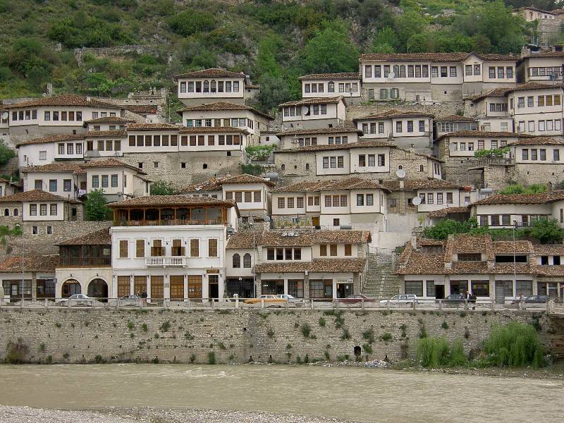
imagesize =
image_caption = Berat old town and river Osum
image_
seal_size =
image_shield =
shield_size =
city_logo =
citylogo_size =
mapsize =
map_caption =
mapsize1 =
map_caption1 =
image_dot_
dot_mapsize =
dot_map_caption =
dot_x = |dot_y =
pushpin_
pushpin_label_position =
pushpin_map_caption =
pushpin_mapsize =
subdivision_type = Country
subdivision_name = ALB
subdivision_type1 = County
subdivision_name1 =Berat County
subdivision_type2 = District
subdivision_name2 =Berat District
subdivision_type3 =
subdivision_name3 =
subdivision_type4 =
subdivision_name4 =
government_footnotes =
government_type =
leader_title = Mayor
leader_name =Fadil Nasufi (PS)
leader_title1 =
leader_name1 =
leader_title2 =
leader_name2 =
leader_title3 =
leader_name3 =
leader_title4 =
leader_name4 =
established_title = Founded
established_date = 6th Century BC
established_title2 =
established_date2 =
established_title3 =
established_date3 =
area_magnitude =
unit_pref = Metric
area_footnotes =
area_total_km2 = 6.3
area_land_km2 =
area_water_km2 =
area_total_sq_mi =
area_land_sq_mi =
area_water_sq_mi =
area_water_percent =
area_urban_km2 =
area_urban_sq_mi =
area_metro_km2 =
area_metro_sq_mi =
population_as_of = 2006
population_footnotes =
nickname =
population_total = 65000
population_density_km2 = 10317
population_density_sq_mi =
population_metro =
population_density_metro_km2 =
population_density_metro_sq_mi =
population_urban =
population_density_urban_km2 =
population_density_urban_sq_mi =
population_blank1_title =
population_blank1 =
population_density_blank1_km2 =
population_density_blank1_sq_mi =
timezone = Central European Time
utc_offset = +1
timezone_DST = CEST
utc_offset_DST = +2
latd=40|latm=47|lats=|latNS=N
longd=19 |longm=57|longs=|longEW=E
elevation_footnotes =
elevation_m = 58
elevation_ft =
postal_code_type =
postal_code =
area_code = 32
blank_name = Car Plates
blank_info = BR
blank1_name =
blank1_info =
website = * [http://www.bashkiaberat.net]
footnotes = Infobox World Heritage Site
WHS = Historic Centres of Berat and Gjirokastra (well-preserved southern Albanian towns bearing outstanding testimony to the Ottoman period in the Balkans)
State Party = ALB
Type = Cultural
Criteria = iii, iv
ID = 569
Region = Europe and North America
Year = 2005
Session = 29th
Extension = 2008
Link = http://whc.unesco.org/en/list/569Berat (also known in Albanian as "Berati", Greek "Bulcheriòpolis"-"Πουλχεριοπολις", "Antipàtrea"-"Αντιπατρια", "Veràtion"-"Βερατιον") is a town located in south-central
Albania . It has a population of around 45,500 people (2003 est). It is the capital of both theDistrict of Berat and the largerCounty of Berat . The old town was inscribed on theWorld Heritage List in July 2008.Berat lies on the right bank of the river Osum, a short distance from the point where it is joined by the
Molisht river. It is remarkable Ottoman town, with a wealth of beautiful buildings of the highest architectural and historical interest. The pine forests above the city, on the slopes of the towering Tomori mountains, provide a backdrop of appropriate grandeur. The Osumi river has cut a 915-metre deep gorge through the limestone rock on the west side of the valley to form a precipitous natural fortress, around which the town was built on several river terraces.According to legend, the Tomorr mountain was originally a giant, who fought with another giant, called Shpirag over a young woman. They killed each other and the girl drowned in her tears, which then became the Osum river.
Mount Shpirag, named after the second giant, is on the left bank of the gorge, above the district of Gorica. Berati is known to Albanians as 'The City of a Thousand Windows' a similar epithet to that sometimes applied to
Gjirokastra , The City of Two Thousand Steps, and has a mixture of Orthodox, Muslim inhabitants. It was proclaimed a 'Museum City' by the dictatorEnver Hoxha in June 1961. It`s population is entirely Albanian. [http://www.coe.int/t/e/human_rights/minorities/2._framework_convention_%28monitoring%29/2._monitoring_mechanism/3._state_reports_and_unmik_kosovo_report/2._second_cycle/PDF_2nd_SR_Albania_Annexes_en.pdf]History
The town is thought to be one of the oldest in Albania, with a settlement having existed there since at least the 6th century BC, when it was a fortress-settlement of the Greek
Dassaretae cite book | first= William | last= Smith | title= A New Classical Dictionary of Greek and Roman Biography, Mythology and Geography | publisher= Kessinger Publishing, LLC | location= Whitefish, MT, USA | year= 2006 | pages=page 423] tribe on the old border betweenIllyria and Epirus.The founder of the town may have been the King ofMacedon ,Cassander , who named it after his fatherAntipater at 314 BC. Known as "Antipatrea ", it was captured by the Romans in the 2nd century BC. The town became part of the unstable frontier of theByzantine Empire following the fall of theRoman Empire and, along with much of the rest of theBalkan peninsula , it suffered from repeated invasions by Slavs and other "barbarian" tribes. During the Byzantine period, it was known as "Pulcheriopolis".The
Bulgarians under Simeon I captured the town in the 9th century and renamed it "Beligrad" (White City).They were eventually driven out in the 11th century. During the 13th century, it fell toMichael I Ducas , the ruler of theDespotate of Epirus .Latter in the 13th century Berat again fell under the control of the Byzantine Empire. In 1280-1281 the Sicilian forces under
Hugh the Red of Sully laid siege to Berat. In March 1281 a relief force fromConstantinople under the command ofMichael Tarchaneiotes was able to drive off the besiging Sicilian army. [Norwich, John Julius. "The Decline and Fall of the Byzantine Empire". (New York: Alfred A. Knopf, 1996) p. 246-247] It passed to theSerbs in 1345.The
Ottoman Empire conquered it in 1450 and retained it until 1912. However, it did not retain direct control for the whole of this period – in 1809, the tyrannicalAli Pasha , who was himself of Albanian origins, seized the town and refortified it. In 1867, Berat became asanjak inJanina (Yanya) vilayet.During the early period of Ottoman rule, Berat fell into severe decline. By the end of the 16th century it had only 710 houses. However it began to recover by the 17th century and became a major craft centre in the Ottoman Balkans specialising in wood carving. During the 19th century, Berat played an important part in the Albanian national revival. It became a major base of support for the
League of Prizren , the late 19th century Albanian nationalist alliance. In November 1944, the communist-controlledAnti-Fascist National Liberation Council of Albania declared in Berat that it was the provisional government of the country, signalling the beginning of the long dictatorship ofEnver Hoxha .Attractions
The Fortress, is built on a rocky hill on the left bank of the river Osum and is accessible only from the south. After being burned down by the Romans in 200 B.C. the walls were strengthened in the fifth century under Byzantine Emperor Theodosius II, and were rebuilt during the 6th century under the Emperor Justinian and again in the 13th century under the Despot of Epirus, Michael Angelus Comnenus, cousin of the Byzantine Emperor. The main entrance, on the north side, is defended by a fortified courtyard and there are three smaller entrances. The fortress of Berat in its present state, even though considerably damaged, remains a magnificent sight. The surface that it encompasses made it possible to house a considerable portion of the cities inhabitants. The buildings inside the fortress were built during the 13th century and because of their characteristic architecture are preserved as cultural monuments. The population of the fortress was Christian, and it had about 20 churches (most built during the 13th century) and only one mosque, for the use of the Turkish garrison, (of which there survives only a few ruins and the base of the minaret). The churches of the fortress were damaged through years and only some have remained.
The Church of St. Mary of Vllaherna dating from the 13th century, has 16th century mural paintings by Nikolla, son of the Albania's most famous medieval painter, Onufri. In a small tree - planted square, on a hillside inside the walls of the fortress, stands the fourteenth century Church of the Holy Trinity. It is built in the form of a Greek cross and has Byzantine murals. Outside the ramparts is the Church of St. Michael (Shen Mehill), Built in the thirteenth century. This church is reached by a steep but perfectly safe path. Near the entrance, after a guardhouse, is the little Church of St. Theodore (Shen Todher), which have wall paintings by Onufri himself. The most interesting is the cathedral of St. Nicholas, which has been well restored and is now a museum dedicated to Onufri. Onufri was the greatest of the 16th century painters in Albania. Not only was he a master of the techniques of fresco and icons, but he was the first to introduce a new colour in painting, pink, which the French called "Onufri's Red". In addition, Onufri introduced a certain realism and a degree of individuality in facial expression.
The first inscription recording Onufri's name was found in 1951, in the Shelqan church. The Kastoria church has a date 23 July 1547 and a reference to Onufri's origin : Une jam Onufri, dhe vij nga qyteti i shkelqyer i Beratit (I am Onufri, and come from the town of Berat). Onufri's style in painting was inherited by his son, Nikolla (Nicholas), though not so successful as his father. In Onufri's museum are to be found works of Onufri, his son, Nikolla and other painters'. There are also numbers of icons and some fine examples of religious silversmith's work (sacred vessels, icon casings, covers of Gospel books, etc). Berat Gospels, which date from the forth century, are copies (the originals are preserved in the National Archives in Tirana). The church itself has a magnificent iconostasis of carved wood, with two very fine icons of Christ and the Virgin Mary. The bishop's throne and the pulpit are also of considerable quality. Near the street running down from the fortress is the Bachelors' Mosque (Xhami e Beqareve), built in 1827. This has a handsome portico and an interesting external decoration of flowers, plants, houses, etc. The 'Bachelors' were the young shop-assistants (in practice generally unmarried), whom the merchants in Berat used as their own private militia. The Sultan's Mosque (Xhamia e Mbretit), the oldest in the town built in the reign of Bayazid II (1481 - 1512), is notable for its fine ceiling.
The Leaden Mosque (Xhamia e Plumbit), built in 1555 and so called from the covering of its cupola. This mosque is the centre of the town. The Tekke of the Helveti (Teqe e Helvetive), of 1790, with a handsome porch and a carved and gilded ceiling. Near of tekke is purported to be the grave of
Shabbatai Zevi , a Turkish Jew who had been banished to Dulcigno (present day Ulcinj) who created controvery among his followers upon his conversion to Islam.ights in Berat
The town is still renowned for its historic architecture and scenic beauty and is known as the "Town of a Thousand Windows", due to the many large windows of the old decorated houses overlooking the town.It is unclear whether it really means "Thousand" (një mijë) or "One over Another" (një mbi një) windows. Indeed, the quarter is built in a very steep place and windows seem to be one over another. Same views can be admired also in Gjrokastër (Albania) and Catanzaro (Italy) where once an Albanian minority lived.The Citadel overlooks the river and the modern city as well as the old Christian quarter across the river. It is a well preserved area containing narrow streets, Turkish houses and Orthodox churches.
Modern Berat consists of three parts divided by the
Ossum River : Goritsa ("little mountain" inOld Slavonic , Mangalem and Kalaja, the latter being a residential quarter within the old Byzantine citadel that overlooks the town. The town also has a 15th century mosque and a number of churches of theAlbanian Orthodox Church , whoseautocephaly was proclaimed there in 1922. Several of the churches house works by the renowned 16th century painterOnufri .Trivia
* The
football (soccer) club isKS Tomori Berat .ee also
*
List of Cities, towns and villages in Albania
*Tourism in Albania References
External links
* [http://www.beratmonument.org.al Berat Official Site]
* [http://www.shqiperia.com/foto/berati.php Photos]

Wikimedia Foundation. 2010.