- Nagpur district
-
This article is about the district. For its eponymous headquarters, see Nagpur.
Nagpur district
नागपूर जिल्हा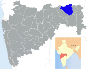
Location of Nagpur district in MaharashtraState Maharashtra,  India
IndiaAdministrative division Nagpur Division Headquarters Nagpur Area 9,897 km2 (3,821 sq mi) Population 46,53,171 (2011) Population density 470 /km2 (1,200 /sq mi) Urban population 64.26% Literacy 89.5% Sex ratio 948 Tehsils 1. Ramtek, 2. Umred, 3. Kalameshwar, 4. Katol, 5. Kamthi, 6. Kuhi, 7. Narkhed, 8. Nagpur, 9. Nagpur (Rural), 10. Parseoni, 11. Bhiwapur, 12. Mouda, 13. Savner, 14. Hingna Lok Sabha Constituencies 1. Nagpur, 2. Ramtek (SC) (Based on Election Commission website) Major highways NH-6, NH-7 Average annual precipitation 1205 mm Official website Nagpur district (Marathi: नागपूर जिल्हा) is a district in the Vidarbha region of Maharashtra state in central India. The city of Nagpur is the district headquarters. The district is part of Nagpur Division.
Nagpur district is bounded by Bhandara district on the east, Chandrapur district on the southeast, Wardha district on the southwest, Amravati district on the northwest and Chhindwara district of Madhya Pradesh state on the north.
Contents
History
In 1853, after the death of Raghoji III, the princely state of Nagpur was annexed by the British and the territory occupied by the present district became part of Nagpur Province. In 1861, it was merged with the Central Provinces and Nagpur district became a part of one of its divisions, Nagpur division. In 1903, it became part of the Central Provinces and Berar. In 1950, Nagpur district became part of the newly-formed Madhya Pradesh state and Nagpur became its capital. In 1956, after the reorganization of states, Nagpur district was incorporated in Bombay state. In 1 May 1960, it became a district of Maharashtra state.
Geography
 Map of Nagpur district with major towns and rivers.
Climate
Nagpur Climate chart (explanation) J F M A M J J A S O N D 1029121232151836191340241643281723826304322429230241943223513320123015172812Average max. and min. temperatures in °C Precipitation totals in mm Source: World Weather Information Service Imperial conversion J F M A M J J A S O N D 0.483540.590590.797660.5104750.6109826.8100791289751187747.68973291680.587590.78354Average max. and min. temperatures in °F Precipitation totals in inches Climate data for Nagpur Month Jan Feb Mar Apr May Jun Jul Aug Sep Oct Nov Dec Year Record high °C (°F) 33
(91)37
(99)41
(106)47
(117)48
(118)45
(113)38
(100)40
(104)39
(102)37
(99)35
(95)32
(90)48
(118)Average high °C (°F) 28.6
(83.5)32.1
(89.8)36.3
(97.3)40.2
(104.4)42.6
(108.7)37.8
(100.0)31.5
(88.7)30.4
(86.7)31.8
(89.2)32.6
(90.7)30.4
(86.7)28.2
(82.8)33.5 Average low °C (°F) 12.4
(54.3)15.0
(59.0)19.0
(66.2)23.9
(75.0)27.9
(82.2)26.3
(79.3)24.1
(75.4)23.6
(74.5)22.9
(73.2)19.8
(67.6)14.9
(58.8)12.1
(53.8)20.2 Record low °C (°F) 7
(45)8
(46)12
(54)17
(63)18
(64)20
(68)20
(68)20
(68)19
(66)11
(52)5
(41)5.5
(41.9)5.9
(42.6)Precipitation mm (inches) 10.2
(0.402)12.3
(0.484)17.8
(0.701)13.2
(0.52)16.3
(0.642)172.2
(6.78)304.3
(11.98)291.6
(11.48)194.4
(7.654)51.4
(2.024)11.8
(0.465)17.2
(0.677)1,112.7
(43.807)Source: [1] Divisions
Nagpur district is divided into 14 talukas: Ramtek, Umred, Kalameshwar, Katol, Kamthi, Kuhi, Narkhed, Nagpur, Nagpur (Rural), Parseoni, Bhiwapur, Mouda, Savner and Hingna.
Nagpur district has 12 Vidhan Sabha constituencies: Nagpur South West, Nagpur South, Nagpur East, Nagpur Central, Nagpur West, Nagpur North, Katol, Savner, Hingna, Umred, Kamthi and Ramtek. The first six constituencies are part of Nagpur Lok Sabha constituency and rest are part of Ramtek Lok Sabha constituency.[2]
Demographics
According to the 2011 census Nagpur district has a population of 4,653,171,[3] roughly equal to the nation of Ireland[4] or the US state of South Carolina.[5] This gives it a ranking of 29th in India (out of a total of 640).[3] The district has a population density of 470 inhabitants per square kilometre (1,200 /sq mi) .[3] Its population growth rate over the decade 2001-2011 was 14.39 %.[3] Nagpur has a sex ratio of 948 females for every 1000 males,[3] and a literacy rate of 89.52 %.[3]
The district had a population of 4,653,171 of which 64.26% were urban as of 2011.[6] The current District Collector is Sanjay Mukherjee. Nagpur district has following administrative bodies which have jurisdiction over different areas[7] -
- Nagpur Municipal Corporation
- Nagpur Improvement Trust
- Narkhed Municipal Council
- Katol Municipal Council
- Saoner Municipal Council
- Ramtek Municipal Council
- Mowad Municipal Council
- Khapa Municipal Council
- Umred Municipal Council
- Narkhed Municipal Council
- Kamptee Municipal Council
- Kalmeshwar Municipal Council
Transport
Dr. Babasaheb Ambedkar International Airport in Sonegaon, Nagpur is a domestic and international airport in this district, which connects Nagpur to Mumbai, Delhi, Sharjah, Dubai and Doha.
References
- ^ "Nagpur, India". Whetherbase. http://www.weatherbase.com/weather/weather.php3?s=35334&refer=&units=metric. Retrieved 2010-07-01.
- ^ "District wise List of Assembly and Parliamentary Constituencies". Chief Electoral Officer, Maharashtra website. http://ceo.maharashtra.gov.in/acs.php. Retrieved 1 November 2010.
- ^ a b c d e f "District Census 2011". Census2011.co.in. 2011. http://www.census2011.co.in/district.php. Retrieved 2011-09-30.
- ^ US Directorate of Intelligence. "Country Comparison:Population". https://www.cia.gov/library/publications/the-world-factbook/rankorder/2119rank.html. Retrieved 2011-10-01. "Ireland 4,670,976 July 2011 est."
- ^ "2010 Resident Population Data". U. S. Census Bureau. http://2010.census.gov/2010census/data/apportionment-pop-text.php. Retrieved 2011-09-30. "South Carolina 4,625,364"
- ^ Census of India
- ^ "Planning Authority of Nagpur district". Government of Maharashtra. http://www.nagpur.nic.in/tp/planningauthorities.htm. Retrieved 2009-01-08.
External links

Chhindwara district, Madhya Pradesh Seoni district, Madhya Pradesh Balaghat district, Madhya Pradesh Amravati district 
Bhandara district  Nagpur district

Wardha district Chandrapur district Nagpur district topics History 
Geography Cities and towns Monuments Deekshabhoomi · Sitabuldi FortEducation Transport Lok Sabha constituencies Vidhan Sabha constituencies Divisions and Districts of Maharashtra Amravati Division Konkan Division Aurangabad Division Nagpur Division Nashik Division Pune Division  State of Maharashtra
Capital : Mumbai Topics Regions Desh · Khandesh · Konkan · Mumbai Metropolitan Region · Marathwada · Vidarbha
Districts Ahmednagar · Akola · Amravati · Aurangabad · Beed · Bhandara · Buldhana · Chandrapur · Dhule · Gadchiroli · Gondia · Hingoli · Jalgaon · Jalna · Kolhapur · Latur · Mumbai (City) · Mumbai (Suburban) · Nagpur · Nanded · Nandurbar · Nashik · Osmanabad · Parbhani · Pune · Raigad · Ratnagiri · Sangli · Satara · Sindhudurg · Solapur · Thane · Wardha · Washim · Yavatmal
Million-plus Cities
in MaharashtraMumbai · Pune · Nagpur · Thane · Pimpri-Chinchwad · Nashik · Kalyan-Dombivali · Navi Mumbai · Aurangabad · Solapur
Other Cities with
Municipal CorporationsAhmednagar · Akola · Amravati · Bhiwandi · Dhule · Jalgaon · Malegaon · Mira-Bhayandar · Ulhasnagar · Vasai-Virar · Kolhapur · Nanded
Portal : Maharashtra


Wikimedia Foundation. 2010.