- Nanded District
-
Nanded district
नांदेड जिल्हा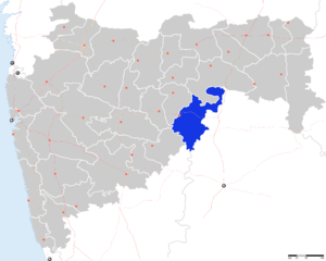
Location of Nanded district in MaharashtraState Maharashtra,  India
IndiaAdministrative division Aurangabad Division Headquarters Nanded Area 10,422 km2 (4,024 sq mi) Population 28,76,259 (2001) Population density 275.98 /km2 (714.8 /sq mi) Urban population 28.29% Literacy 68.52% Sex ratio 942 Tehsils Lok Sabha Constituencies 1. Nanded,
2. Hingoli (shared with Hingoli District)
(Based on Election Commission official website)Major highways NH-222 Average annual precipitation 954 mm Official website Nanded district (Marathi: नांदेड जिल्हा) is a district of Maharashtra state in central India. The city of Nanded is the district headquarters.
Contents
Overview
The district has an area of 10,502 km² while according to 2001 census its population is 2,876,259 of which 23.96% were urban.[1] The Godavari River flows through the district.
Nanded District lies in the eastern portion of Marathwada region, which corresponds to Aurangabad Division of Maharashtra. The district is bounded by Nizamabad, Medak and Adilabad districts of Andhra Pradesh on the east, by Bidar District of Karnataka falls on the south, by Parbhani and Latur districts of Marathwada on the west, and Yavatmal District of Maharashtra's Vidarbha region on the north. The influence of Andhra, Karnataka and Vidarbha can be seen on the language, behaviour and general conduct of the people of Nanded.
Geographical Area : 10,502 km²
Total Population : 28,68,158
Male : 14.76 Lakhs
Female : 13.91 Lakhs
Urban to Total Population : 28.29 %
Normal Rainfall : 901 mm
Taluka : 16
Per Capita Income : Rs.2,123
Population (1991 Census, in 1000s) : 2,330 (Males=1,198 Females=1,132)
Density : 220 per km²
Literacy : 68.52%
Male Literacy : 81.14%
Female Literacy : 55.12 %
Amenities and infrastructural facilitiesTotal inhabited villages: 1,546
Amenities No. of villages
Drinking water facilities: 1,538
Important Towns (Largest three) Safe Drinking water: 1,537
Population Electricity (Power Supply): 1,531
Primary school: 1,536
Middle schools: 768
Secondary/Sr Secondary schools: 504
College: 26
Medical facility: 209
Primary Health Centre: 71
Primary Health Sub-Centre: 111
Bus services: 1,141
Paved approach road: 1,049
Mud approach road: 4
Historical Importance : Sachkhand Hazursahib Gurudwara, Renuka Devi Mandir Mahur Dargah at Kandhar
Commercial Banks : 132
Industrial Estates : Nanded, Dharmabad, Loha, Degloor, Kinwat.
Cinema Theatres : 6History
Even though Nanded is only mentioned in historical accounts since 4th century, the evidence of human habitation in this area has been found for the past 40 to 50 thousand years[citation needed].
Upon reorganization of states in 1956, the district of Nanded came to comprise six talukas namely Kandhar, Hadgaon, Biloli, Degloor, Mudhol whereas Mukhed and Bhokar were called Mahals (revenue head quarters). As a result of reorganization of states, Bichkunda, Jukkal villages of Degloor taluka as well as the whole of Mudhol taluka (excluding Dharmabad) were merged with Nizamabad District of Andhra Pradesh. In lieu of them, Kinwat and Islapur villages were separated from Adilabad District and made part of Nanded District again. Islapur village was combined with Kinwat taluka and Dharmabad came to be merged with Biloli taluka.
Nanded is mentioned in the Ramayana, as the place where Bharat's mother came from. The 10th and last living guru of Sikhs, Shri. Guru Gobind Singhji stayed in Nanded for a long time and it is from here that he transferred the title of Guru to "Guru Granthsahib". Recently Mahur was declared as a Taluka. Mahur has religious importance.
One can reach Nanded from Delhi by trains named Sachakhand Express and SriGanganager Express. From Mumbai there are three trains, Devgiri Express, Nandigram Express and Tapovan Express. It is also well connected with southern part of India. Devgiri express is extends its journey till Hyderabad and Bangalore Express runs from Nanded to Bangalore.
Economy
In 2006 the Ministry of Panchayati Raj named Nanded one of the country's 250 most backward districts (out of a total of 640).[2] It is one of the twelve districts in Maharashtra currently receiving funds from the Backward Regions Grant Fund Programme (BRGF).[2]
Demographics
According to the 2011 census Nanded District has a population of 3,356,566 ,[3] roughly equal to the nation of Uruguay[4] or the US state of Connecticut.[5] This gives it a ranking of 99th in India (out of a total of 640).[3] The district has a population density of 319 inhabitants per square kilometre (830 /sq mi) .[3] Its population growth rate over the decade 2001-2011 was 16.7 %.[3] Nanded has a sex ratio of 937 females for every 1000 males,[3] and a literacy rate of 76.94 %.[3]
Languages
Languages used in the district include Andh, an Indo-Aryan language spoken by 100 000 people.[6]
References
- ^ [1]
- ^ a b Ministry of Panchayati Raj (September 8, 2009). "A Note on the Backward Regions Grant Fund Programme". National Institute of Rural Development. http://www.nird.org.in/brgf/doc/brgf_BackgroundNote.pdf. Retrieved September 27, 2011.
- ^ a b c d e f "District Census 2011". Census2011.co.in. 2011. http://www.census2011.co.in/district.php. Retrieved 2011-09-30.
- ^ US Directorate of Intelligence. "Country Comparison:Population". https://www.cia.gov/library/publications/the-world-factbook/rankorder/2119rank.html. Retrieved 2011-10-01. "Uruguay 3,308,535 July 2011 est."
- ^ "2010 Resident Population Data". U. S. Census Bureau. http://2010.census.gov/2010census/data/apportionment-pop-text.php. Retrieved 2011-09-30. "Connecticut 3,574,097"
- ^ M. Paul Lewis, ed (2009). "Andh: A language of India". Ethnologue: Languages of the World (16th edition ed.). Dallas, Texas: SIL International. http://www.ethnologue.com/show_language.asp?code=anr. Retrieved 2011-09-28.
External links

Hingoli district Yavatmal district Adilabad district, Andhra Pradesh Parbhani district 
Nizamabad district, Andhra Pradesh  Nanded district

Latur district Bidar district, Karnataka Divisions and Districts of Maharashtra Amravati Division Konkan Division Aurangabad Division Nagpur Division Nashik Division Pune Division  State of Maharashtra
Capital : Mumbai Topics Regions Desh · Khandesh · Konkan · Mumbai Metropolitan Region · Marathwada · Vidarbha
Districts Ahmednagar · Akola · Amravati · Aurangabad · Beed · Bhandara · Buldhana · Chandrapur · Dhule · Gadchiroli · Gondia · Hingoli · Jalgaon · Jalna · Kolhapur · Latur · Mumbai (City) · Mumbai (Suburban) · Nagpur · Nanded · Nandurbar · Nashik · Osmanabad · Parbhani · Pune · Raigad · Ratnagiri · Sangli · Satara · Sindhudurg · Solapur · Thane · Wardha · Washim · Yavatmal
Million-plus Cities
in MaharashtraMumbai · Pune · Nagpur · Thane · Pimpri-Chinchwad · Nashik · Kalyan-Dombivali · Navi Mumbai · Aurangabad · Solapur
Other Cities with
Municipal CorporationsAhmednagar · Akola · Amravati · Bhiwandi · Dhule · Jalgaon · Malegaon · Mira-Bhayandar · Ulhasnagar · Vasai-Virar · Kolhapur · Nanded
Portal : Maharashtra Categories:- Districts of Maharashtra
- Nanded district
- Aurangabad division

Wikimedia Foundation. 2010.