Nonington

Nonington

Coordinates: 51°13′38″N 1°13′42″E / 51.2271°N 1.2283°E / 51.2271; 1.2283

Nonington
Nonington village hall, Kent.jpg
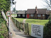
Nonington youth club
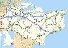
Nonington is located in Kent
Nonington

 Nonington shown within Kent
OS grid reference TR255525
District Dover
Shire county Kent
Region South East
Country England
Sovereign state United Kingdom
Postcode district CT15
Police Kent
Fire Kent
Ambulance South East Coast
EU Parliament South East England
UK Parliament Dover
List of places: UK • England • Kent

Nonington, also, variously, Nonnington, Nunyngton, Nonnyngton, Nunnington, is a small village in the southeast corner of Kent, situated halfway between the historic city of Canterbury and the channel port town of Dover. The parish of Nonington was once made up of the now separate parishes of Nonington and Aylesham.It also has a Baptist chapel, linked to Eythorne Baptist Church. It is home to The Bruderhof who have taken over the old Nonington College of Physical Education, previously St. Alban's Court, the home of the Hammond family from the Reformation until the late 1930's. Nonington has its own primary school; Nonington CE Primary School.

Nonington has been in the Guinness Book of Records for their Majesty Oak, the largest maiden oak tree in the UK which can be found in Fredville Park.

External links

http://www.nonington.org.uk


Wikimedia Foundation. 2010.

Игры ⚽ Нужен реферат?

Look at other dictionaries:

  • List of schools in Kent — List of primary schools, middle schools, secondary schools, special schools, further education colleges and universities in the ceremonial county of Kent, England. [cite web | title = UK Schools Colleges Database | publisher = Schools Web… …   Wikipedia

  • Dover (district) — Dover District   Non metropolitan district   Dover shown within Kent Sovereign state …   Wikipedia

  • List of Grade I listed buildings in Kent — There are over 6000 Grade I listed buildings in England. This page is a list of these buildings in the county of Kent.Ashford* Church of St Martin, Aldington * Church of SS Peter Paul, Appledore * Church of St Margaret, Bethersden * 3 High St,… …   Wikipedia

  • Barfrestone — Église St Nicholas Administration Pays …   Wikipédia en Français

  • Sandwich, Kent — Coordinates: 51°16′29″N 1°20′20″E / 51.27472°N 1.33889°E / 51.27472; 1.33889 For other uses, see Sandwich (di …   Wikipedia

  • Deal, Kent — Coordinates: 51°13′21″N 1°24′02″E / 51.2226°N 1.4006°E / 51.2226; 1.4006 …   Wikipedia

  • Drellingore — Coordinates: 51°07′26″N 1°12′00″E / 51.124°N 1.2°E / 51.124; 1.2 …   Wikipedia

  • Maxton, Kent — Coordinates: 51°07′13″N 1°17′20″E / 51.1204°N 1.2889°E / 51.1204; 1.2889 …   Wikipedia

  • Martin, Kent — For other places with the same name, see Martin (disambiguation). Coordinates: 51°10′44″N 1°20′22″E / 51.1790°N 1.3394°E / 51.1790; 1.3394 …   Wikipedia

  • Martin Mill — Coordinates: 51°10′11″N 1°21′11″E / 51.1696°N 1.3530°E / 51.1696; 1.3530 …   Wikipedia

Share the article and excerpts

Direct link
Do a right-click on the link above
and select “Copy Link”