- Clayton/Tamm, St. Louis
-
Clayton/Tamm ("Dogtown")
Neighborhoods of St. Louis, Missouri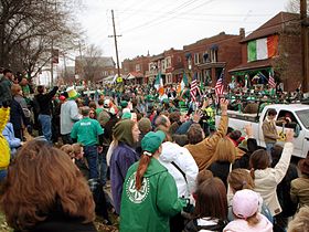
Clayton-Tamm is home to the popular Ancient Order of Hibernians Parade in Dogtown. Government Country United States State Missouri City St. Louis Wards 24 Statistics Total area 0.36 sq mi (0.93 km2) Population (2010) 2,251[1] Density 6,252 /sq mi (2,414 /km2) Miscellaneous ZIP code(s) Part of 63139 Area code(s) 314 Website http://stlouis.missouri.org/claytontamm/ Location 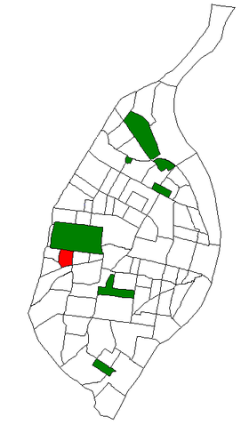
Location of Clayton/Tamm (Dogtown) within St. Louis. For other uses, see Dogtown (disambiguation).Clayton-Tamm is a traditionally Irish-American neighborhood located near the western border of St. Louis, Missouri, USA, just south of Forest Park.
Its borders are Hampton Avenue to the east, Manchester Road to the south, McCausland Avenue on the west and Oakland/Highway 40/64 to the north.
Its name is derived from the intersecting streets of Clayton Ave and Tamm Ave (Lat: 38.628599, Lon: -090.292882), which is the center of the neighborhood's business district. The Clayton-Tamm neighborhood is one of three (with Franz Park and the Ellendale) which make up the widely renowned Irish section of St. Louis called "Dogtown".
The earliest development in the (not yet) neighborhood was by Charles Gratiot, who in 1785 requested use of the land from Spanish authorities in the French-owned land before the Louisiana Purchase "to cultivate wheat, hemp, corn, tobacco, etc., etc." (Requoted from McCune Gill by Bob Corbett, 2000) The grant was formalized by the Spanish governor in 1798 and reaffirmed in 1808 by the US after the Louisiana Purchase. After Charles' Death his large land grant was divided into 12 strips and given as inheritance.
Major growth in Cheltenham (Dogtown) defined the region in the late 19th century as it developed into a coal and clay mining community. Growth was further accelerated by preparations and construction for the 1904 World's Fair, "The Louisiana Purchase Exposition" held in nearby Forest park.
While there are a number of theories as to why this neighborhood is known as Dogtown, the most credible account describes a group of coal miners working in what is today Forest Park. When the city acquired the land to build the park in 1876, these people found sparsely populated areas south of the new park and built shacks to live in as they found new work. In order to secure their ramshackle homes, many of the squatters used watchdogs, which would defend their territory.
Dogtown is home to the annual St. Patrick's Day Parade, which is the more authentic of the two St. Louis parades for this holiday. On March 17th, thousands gather to watch the Ancient Order of Hibernians' parade, which runs down Tamm Avenue and features many local Irish Schools of Dance.
References
External links
Categories:- Irish-American neighborhoods
- Neighborhoods in St. Louis, Missouri


Wikimedia Foundation. 2010.