- Tikamgarh District
-
This article is about the district. For its eponymous headquarters, see Tikamgarh.
Tikamgarh district
टीकमगढ़ जिला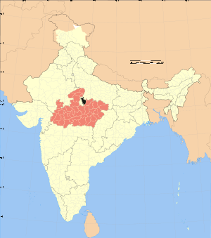
Location of Tikamgarh district in Madhya PradeshState Madhya Pradesh,  India
IndiaAdministrative division Sagar Headquarters Tikamgarh Area 5,048 km2 (1,949 sq mi) Population 1,202,998 (2001) Population density 297 /km2 (770 /sq mi) Urban population 30.40% Literacy 65% Sex ratio 886 Tehsils 1. Tikamgarh, 2. Prithvipur, 3. Jatara, 4. Baldeogarh, 5. Niwari and 6. Palera,7. Badagaon. Lok Sabha Constituencies Tikamgarh Assembly Seats 1. Tikamgarh, 2. Prithvipur, 3. Jatara, 4. Khargapur and 5. Niwari Major highways NH-12A ,SH-37 ,SH10 Official website Tikamgarh district (Hindi: टीकमगढ़ जिला) is one of the 50 districts of Madhya Pradesh state in central India. Tikamgarh town is the district headquarters. The district is part of Sagar Division.
It is bounded on the east and southeast by Chhatarpur District of Madhya Pradesh, and by the Uttar Pradesh districts of Lalitpur on the west and Jhansi on the north. Tikamgarh District has an area of 5048 km².
Contents
Origin of name
The district is named after its headquarters, Tikamgarh. The original name of the town was Tihri. In 1783, the ruler of Orchha Vikramajit (1776–1817) shifted his capital from Orchha to Tihri and renamed it Tikamgarh (Tikam is one of the names of Krishna).
History
The area covered by this district was part of the Princely State of Orchha till its merger with the Indian Union. The Orchha state was founded by Rudra Pratap in 1501. After merger, it became one of the eight districts of Vindhya Pradesh state in 1948. Following the reorganization of states on 1 November 1956 it became a district of the newly carved Madhya Pradesh
Orchha was founded in the 1501 AD,[1] by the Bundela chief, Rudra Pratap Singh, who became the first King of Orchha, (r. 1501-1531) and also built the Fort of Orchha.[2] He died in an attempt to save a cow from a lion. The Chaturbhuj Temple was built, during the time of Akbar, by the Queen of Orchha,[3] while Raj Mandir was built by 'Madhukar Shah' during his reign, 1554 to 1591.[4][5]
During the rule of Mughal Emperor, Jahangir, his ally, Bir Singh Deo (r. 1605-1627) reigned here, and it was during this period that Orchha reaches its height, and many extant palaces are a reminder of its architectural glory, including Jahangir Mahal (b. ca 1605) and Sawan Bhadon Mahal.[6]
In the early 17th century, Raja Jujhar Singh rebelled against the Mughal emperor Shah Jahan, whose armies devastated the state and occupied Orchha from 1635 to 1641. Orchha and Datia were the only Bundela states not subjugated by the Marathas in the 18th century. The town of Tehri, presently Tikamgarh, about 52 miles (84 km) south of Orchha, became the capital of Orchha state in 1783, and is presently the district town; Tehri was the site of the fort of Tikamgarh, and the town eventually took the name of the fort.[7]
 Flag of princely state of orchha,TKG
Hamir Singh, who ruled from 1848 to 1874, was elevated to the style of Maharaja in 1865. Maharaja Pratap Singh (born 1854, died 1930), who succeeded to the throne in 1874, devoted himself entirely to the development of his state, himself designing most of the engineering and irrigation works that were executed during his reign.
In 1901, the state had an area of 2,000 sq mi (5,200 km2), and population of 52,634. It was the oldest and highest in rank of all the Bundela states, with a 17-gun salute, and its Maharajas bore the hereditary title of First of the Prince of Bundelkhand. Vir Singh, Pratap Singh's successor, merged his state with the Union of India on January 1, 1950. The district became part of Vindhya Pradesh state, which was merged into Madhya Pradesh state in 1956. Today Orchha is almost a nondescript town with a small population, and its importance is maintained only due to its rich architectural heritage and tourism.
Books on the rich history of Orchha are available in local shops, mostly in the Hindi language. Only a thorough reading of some of this material will tell about the rich and varied history of this place.
Economy
In 2006 the Ministry of Panchayati Raj named Tikamgarh one of the country's 250 most backward districts (out of a total of 640).[8] It is one of the 24 districts in Madhya Pradesh currently receiving funds from the Backward Regions Grant Fund Programme (BRGF).[8]
Demographics
According to the 2011 census Tikamgarh District has a population of 1,444,920,[9] roughly equal to the nation of Swaziland[10] or the US state of Hawaii.[11] This gives it a ranking of 343rd in India (out of a total of 640).[9] The district has a population density of 286 inhabitants per square kilometre (740 /sq mi) .[9] Its population growth rate over the decade 2001-2011 was 20.11 %.[9] Tikamgarh has a sex ratio of 901 females for every 1000 males,[9] and a literacy rate of 62.57 %.[9]
Languages
Vernaculars used in Tikamgarh include Bharia, a Dravidian language spoken by at least 200 000 members of the Bharia tribe and written in the Devanagari script.[12]
Communication
Postage stamps of this feudatory state were prepared for use in 1897 but were never issued. First Orchha State stamps were issued in 1913. Separate stamps were discontinued on 30 April 1950 after the state was merged with the Union of India early that year.
Transportation
Tikamgarh has the biggest Bus Stand of madhya pradesh.
 Welcome gate at Jhansi Road In TKG
Roads
There are daily service of buses for every part of state.
-
- Highways Passing from Tikamgarh Are NH-12,SH-37,SH-10.
Apart it buses for new delhi, Nagpur, Kanpur, Indore, Bhopal, Gwalior, Jabalpur are also there.
Railways
The construction of railway line to Tikamgarh is in progress.... it will be completed in 2014.
Lalitpur (55 km) is the nearest railway station.
Airways
Khajuraho is the nearest (125 km) airfort from where a daily flight for Delhi & Agra.
Tourism
Tikamgarh District have many tourist places like:-
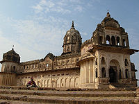
Orchha:- World famous for Ramraja Temple.
 Lakshmi Temple, Orchha.
Kundeshwar:-Famous for Lord Shiva temple.
Baldeogarh:-Baldeogarh ki TOP (तोप) is famous in Bundelkhand. Achharu mata:-Famous for Lord Durga Temple.
Civic administration
Tikamgarh City Officials MP Veerendra kumar Khatik[13] IAS Mr.Raghu Raj[14] IPS Officer Dr.Akash Jindal[14] Geography
Rivers and lakes
The Betwa River flows along the northwestern boundary of the district and Dhasan River, one of its tributaries flows along the eastern boundary of the district. Both of these rivers flow towards the northeast. The tributaries of the Betwa flowing through this district are Jamni, Bagri and Barua. new river in come to
Historical place
ORCHHA: Orchha is world famous religious & tourist places, earning the foreign currency known mainly for Ram Raja temple. Except this, few more temples and forts are worth seeing.
KUNDESHWAR: Kundeshwar is a village situated in Tikamgarh District, 5 km south of Tikamgarh, Madhya Pradesh, India. It is known for kundadev Mahadev an ancient temple on the bank of the Jamdhar river, and is the location of Kundadev Mahadev Temple. According to ethics, Banpur was the capital of Banasur the king of demons and her daughter Usha Devi was a dedicated and regular devotee of this Shiv Linga of Mahadev in midnight. Usha Devi was married to Anirudha, the grandson of Lord Krishna and son of Pradumna. It is believed, that that Shiv Linga has emerged from the Kunda of Bagwar Kshatriya, Rajput clan landlady.
Divisions
Tikamgarh district is divided into three sub-divisions, which are further divided into six tehsils. The Tikamgarh sub-division comprises Tikamgarh and Baldeogarh tehsils. Niwari and Prithvipur tehsils form Niwari sub-division while Jatara sub-division comprises Jatara and Palera tehsils. The district consists six development blocks, namely Tikamgarh, Baldeogarh, Jatara, Palera, Niwari and Prithvipur.
There are 5 Madhya Pradesh Vidhan Sabha constituencies in this district: Tikamgarh, Prithvipur, Jatara, Khargapur and Niwari. All of these are part of Tikamgarh Lok Sabha constituency
References
- ^ Orchha Tikamgarh district Official website.
- ^ .co.uk/personalisation/PHO000430S21U00011000 Mausoleum of Raja Rudra Pratap British Library.
- ^ Orchha British Library.
- ^ Genealogy of Orchha
- ^ Raj Mandir British Library.
- ^ Swan Bhadon Palace, Orcha British Library.
- ^ Orchha state The Imperial Gazetteer of India, 1909, v. 19, p. 241.
- ^ a b Ministry of Panchayati Raj (September 8, 2009). "A Note on the Backward Regions Grant Fund Programme". National Institute of Rural Development. http://www.nird.org.in/brgf/doc/brgf_BackgroundNote.pdf. Retrieved September 27, 2011.
- ^ a b c d e f "District Census 2011". Census2011.co.in. 2011. http://www.census2011.co.in/district.php. Retrieved 2011-09-30.
- ^ US Directorate of Intelligence. "Country Comparison:Population". https://www.cia.gov/library/publications/the-world-factbook/rankorder/2119rank.html. Retrieved 2011-10-01. "Swaziland 1,370,424"
- ^ "2010 Resident Population Data". U. S. Census Bureau. http://2010.census.gov/2010census/data/apportionment-pop-text.php. Retrieved 2011-09-30. "Hawaii 1,360,301"
- ^ M. Paul Lewis, ed (2009). "Bharia: A language of India". Ethnologue: Languages of the World (16th edition ed.). Dallas, Texas: SIL International. http://www.ethnologue.com/show_language.asp?code=bha. Retrieved 2011-09-28.
- ^ "Indore Parshad/Mayor". Indore Municipal Corporation. 2010-08-08. http://www.imcindore.org/parshad.jsp. Retrieved 2010-08-08.
- ^ a b "From The Collector's Desk". Indore District Administration. 2010-03-17. http://www.indore.nic.in/collector.htm. Retrieved 2010-05-13.
External links

Jhansi district, Uttar Pradesh 
 Tikamgarh district

Lalitpur district, Uttar Pradesh Chhatarpur district Divisions & Districts of Madhya Pradesh · 
Bhopal Division: Chambal Division: Gwalior Division: Ashoknagar · Datia · Guna · Gwalior · Shivpuri
Indore Division: Jabalpur Division: Narmadapuram Division: Betul · Harda · Hoshangabad
Rewa Division: Sagar Division: Chhatarpur · Damoh · Panna · Sagar · Tikamgarh
Shahdol Division: Ujjain Division: Cities and towns in Sagar Division Chhatarpur district Bada Malhera • Barigarh • Bijawar • Buxwaha • Chandla • Chhatarpur • Garhi-Malhara • Ghuwara • Harpalpur • Laundi • Maharajpur • Nowgaon • Rajnagar • SataiDamoh district Panna district Sagar district Bina Etawa • Bina Railway Colony • Deori • Dhana • Garhakota • Khurai • Makronia • Mandi Bamora • Rahatgarh • Rehli • Sagar Cantonment • Sagar • Shahgarh • ShahpurTikamgarh district Badagaon • Baldeogarh • Jatara • Jeron Khalsa • Kari • Khargapur • Lidhorakhas • Niwari • Orchha • Palera • Prithvipur • Taricharkalan • TikamgarhRelated topics Categories: -


Wikimedia Foundation. 2010.