- Monongahela Incline
-
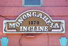
Monongahela Incline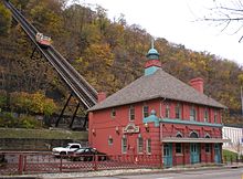
Monongahela InclineOverview Type funicular Locale Pittsburgh, PA Termini West Carson Street
Grandview AvenueStations 2 Operation Opened May 28, 1870 Owner Port Authority of Allegheny County Technical Line length 635 feet (194 m) Track gauge 5 ft (1,524 mm) Electrification 1935 Operating speed 6 mph (9.7 km/h) Coordinates: 40°25′55″N 80°00′19″W / 40.4319°N 80.0054°W
The Monongahela Incline, built by John Endres in 1870, is located near the Smithfield Street Bridge in Pittsburgh. It is the oldest continuously operating funicular in the USA. It is also one of two surviving inclines (the other is the nearby Duquesne Incline) from the original 17 passenger-carrying inclines built in Pittsburgh starting in the late 19th century. Its lower station is across the street from the Station Square shopping complex, and is easily accessible from the light rail system at the Station Square station.
Contents
History
Pittsburgh's expanding industrial base in 1860 created a huge demand for labor, attracting mainly German immigrants to the region. This created a serious housing shortage as industry occupied most of the flat lands adjacent to the river, leaving only the steep, surrounding hillsides of Mt. Washington or "Coal Hill" for housing. However, travel between the "hill" and other areas was hindered by a lack of good roads or public transport.
The predominantly German immigrants who settled on Mt. Washington, remembering the Seilbahns (cable cars) of their former country, proposed the construction of inclines along the face of Coal Hill. The result was the Monongahela Incline, which opened May 28, 1870.[1] Earlier inclines were used to transport coal in the Pittsburgh area, including the Kirk Lewis incline on Mt. Washington and the Ormsby mine gravity plane in nearby Birmingham, later annexed to the city of Pittsburgh.
It is operated by the Port Authority of Allegheny County, which operates the rest of Pittsburgh's transit system. Transfers can be made between the incline and the light rail and buses.[2]
 The incline in 1905. The Monongahela Freight Incline is to the left of the original.
Statistics
- Length: 635 feet (194 m)
- Elevation: 369.39 feet (112.59 m)
- Grade: 35 degrees, 35 minutes
- Gauge: 5 ft (1,524 mm)
- Speed: 6 mph (9.7 km/h)
- Passenger Capacity: 23 per car
- Opened: 28 May 1870
- Renovated: 1882 (with steel structure)
- Original steam power replaced with electricity: 1935
- Renovated: 1982-83 new track structure, cars and stations
- Renovated: 1994 upper, lower stations, restored cars, replaced electric motors and controls[3]
Gallery
 The view from the top, upper station on right of picture
-

Ascending -

Descending
See also
- Duquesne Incline
- Monongahela Freight Incline
- Angels Flight
- Johnstown Inclined Plane
- Funicular railway
- List of funicular railways
- Port Authority of Allegheny County: The Inclines
References
- ^ "Inclines Rise to National Landmarks". Pittsburgh Post-Gazette (Pittsburgh, Pennsylvania): p. 5. 7 May 1977. http://news.google.com/newspapers?nid=1129&dat=19770507&id=Ck4NAAAAIBAJ&sjid=Om0DAAAAIBAJ&pg=6087,858396. Retrieved 3 January 2010.
- ^ "Port Authority of Allegheny County: The Inclines". 2007. http://www.portauthority.org/PAAC/Schedules/Inclines/tabid/119/Default.aspx. Retrieved November 26, 2010.
- ^ "Monongahela and Duquesne Inclines". http://files.asme.org/ASMEORG/Communities/History/Landmarks/5533.pdf. Retrieved 2009-05-21.
External Links
Public Transportation in Greater Pittsburgh Bus Services Port Authority of Allegheny County (list of bus routes) | Beaver County Transit Authority | Butler Transit Authority | Fayette Area Coordinated Transportation | Mid Mon Valley Transit Authority | New Castle Area Transit Authority | Town & Country Transit | University of Pittsburgh Transportation System | Washington City Transit | Westmoreland County Transit Authority
Bus Rapid Transit Martin Luther King Jr. East Busway | South Busway | West Busway
Light Rail The T light rail | Red Line | Blue Line - Library | Blue Line - South Hills Village | Brown Line (suspended)
Inclines Duquesne Incline | Monongahela Incline
Intercity Rail Amtrak | Capitol Limited | Pennsylvanian
Airports U.S. National Register of Historic Places in Pennsylvania Topics 
Lists by county Adams • Allegheny • Armstrong • Beaver • Bedford • Berks • Blair • Bradford • Bucks • Butler • Cambria • Cameron • Carbon • Centre • Chester: (East | North | South) • Clarion • Clearfield • Clinton • Columbia • Crawford • Cumberland • Dauphin • Delaware • Elk • Erie • Fayette • Forest • Franklin • Fulton • Greene • Huntingdon • Indiana • Jefferson • Juniata • Lackawanna • Lancaster • Lawrence • Lebanon • Lehigh • Luzerne • Lycoming • McKean • Mercer • Mifflin • Monroe • Montgomery • Montour • Northampton • Northumberland • Perry • Philadelphia • Pike • Potter • Schuylkill • Snyder • Somerset • Sullivan • Susquehanna • Tioga • Union • Venango • Warren • Washington • Wayne • Westmoreland • Wyoming • YorkLists by city Pittsburgh • Lancaster • Philadelphia: (Center City | North | Northeast | Northwest | South | Southwest | West)Other lists Bridges (Covered Bridges) • National Historic Landmarks (Philadelphia) Category:National Register of Historic Places in Pennsylvania •
  Portal:National Register of Historic PlacesCategories:
- Buildings and structures on the National Register of Historic Places in Pennsylvania
- Funicular railways of the United States
- Transportation in Pittsburgh, Pennsylvania
- City of Pittsburgh historic designations
- Pittsburgh History & Landmarks Foundation Historic Landmarks
- Railway inclines in Pittsburgh, Pennsylvania
- Port Authority of Allegheny County
- Visitor attractions in Pittsburgh, Pennsylvania
- 5ft gauge railways


Wikimedia Foundation. 2010.