Marefield Junction railway station — Marefield Junction was a railway station in Marefield, Leicestershire. Services ran eastwards to Leicester, northwards to Nottingham and south to Market Harborough. [British Railways Atlas.1947. p.16] Former Services References … Wikipedia
Marefield Junction — A 1903 Railway Clearing House Junction Diagram showing (top centre) Marefield Junction Marefield Junction was a railway junction in Marefield, Leicestershire, England. Railway lines from the triangular junc … Wikipedia
Thomas Hooker — For the State Representative, see Thomas Hooker (Michigan politician). For the singer, see Tom Hooker. Thomas Hooker Hooker s Company reach the Connecticut, publishers: Estes Lauriat, 1879 Born July 5, 1586(1586 07 05) … Wikipedia
Great Northern and London and North Western Joint Railway — Overview= The Great Northern and London and North Western Joint Railway was a joint railway owned by the Great Northern Railway (GNR) and the London and North Western Railway (LNWR) in east Leicestershire. LocationThe joint line started from… … Wikipedia
Leicester Belgrave Road railway station — Infobox UK disused station name = Leicester Belgrave Road gridref = SK592057 caption = manager = Great Northern Railway owner = LNER locale = Leicester borough = Leicestershire platforms = 5 years = 1 January 1883 events = Opened years1 = 7… … Wikipedia
Great Northern Railway (Great Britain) — The Great Northern Railway (GNR) was a British railway company established by the London York Railway Act of 1846. The main line ran from London via Hitchin, Peterborough, and Grantham, to York, with a loop line from Peterborough to Bawtry (south … Wikipedia
Harborough — This is about the district of Harborough; there is also the Harborough constituency. Infobox UK district name = Harborough District status = District region = East Midlands admincounty = Leicestershire area = Ranked 79th 592.70 km² adminhq =… … Wikipedia
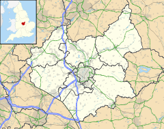
List of places in Leicestershire — Location map+|Leicestershire caption = Some of the larger settlements of Leicestershire. float = right width = 350 places = Location map |Leicestershire label = Melton Mowbray long = 0.886 lat = 52.7661 background = white Location map… … Wikipedia
Tilton on the Hill — is a village and civil parish in the Harborough district of Leicestershire. It lies some way north of the A47, on the B6047 to Melton Mowbray.Apart from Tilton proper the parish includes Marefield, Halstead and Whatborough. St. Peter s, Tilton,… … Wikipedia
List of civil parishes in Leicestershire — Blaby= *Aston Flamville 1 *Blaby 1 *Town of Braunstone 1 *Cosby 1 *Countesthorpe 1 *Croft 1 *Elmesthorpe 1 *Enderby 1 *Glenfield (Glenfields) 1 *Glen Parva 1 *Huncote 1 *Kilby 1 *Kirby Muxloe 1 *Leicester Forest East 1 *Leicester Forest West 1… … Wikipedia
 Marefield
 Riders on horseback approaching Maresfield, Leicestershire
 Media related to Marefield at Wikimedia CommonsCategories:
