- Aegean Sea
-
For the oil tanker Aegean Sea, see Aegean Sea oil spill.

The Aegean Sea[p] (Greek: Αιγαίο Πέλαγος, Egeo Pelagos [eˈʝeo ˈpelaɣos] (
 listen); Turkish: Ege Denizi or historically Turkish: Adalar Denizi[1]) is an elongated embayment of the Mediterranean Sea located between the southern Balkan and Anatolian peninsulas, i.e., between the mainlands of Greece and Turkey. In the north, it is connected to the Marmara Sea and Black Sea by the Dardanelles and Bosporus. The Aegean Islands are within the sea and some bound it on its southern periphery, including Crete and Rhodes. The Aegean Region consists of nine provinces in southwestern Turkey, in part bordering on the Aegean sea.
The sea was traditionally known as Archipelago (in Greek, Αρχιπέλαγος, meaning "chief sea"), but in English this word's meaning has changed to refer to the Aegean Islands and, generally, to any island group.
Contents
Geography
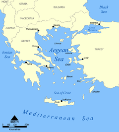
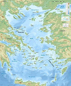
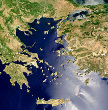
The Aegean Sea covers about 214,000 square kilometres (83,000 sq mi) in area, and measures about 610 kilometres (380 mi) longitudinally and 300 kilometres (190 mi) latitudinally. The sea's maximum depth is 3,543 metres (11,624 ft), east of Crete. The Aegean Islands are found within its waters, with the following islands delimiting the sea on the south (generally from west to east): Kythera, Antikythera, Crete, Kasos, Karpathos and Rhodes.
The Aegean Islands, which almost all belong to Greece, can be divided into seven groups:
- Northeastern Aegean Islands
- Euboea
- Northern Sporades
- Cyclades
- Saronic Islands (or Argo-Saronic Islands)
- Dodecanese (or Southern Sporades), with the exclusion of Kastelorizo
- Crete
The word archipelago was originally applied specifically to the Aegean Sea and its islands. Many of the Aegean Islands, or chains of islands, are actually extensions of the mountains on the mainland. One chain extends across the sea to Chios, another extends across Euboea to Samos, and a third extends across the Peloponnese and Crete to Rhodes, dividing the Aegean from the Mediterranean.
The bays and gulfs of the Aegean beginning and the South and moving clockwise include on Crete, the Mirabelli, Almyros, Souda and Chania bays or gulfs, on the mainland the Myrtoan Sea to the west, the Saronic Gulf northwestward, the Petalies Gulf which connects with the South Euboic Sea, the Pagasetic Gulf which connects with the North Euboic Sea, the Thermian Gulf northwestward, the Chalkidiki Peninsula including the Cassandra and the Singitic Gulfs, northward the Strymonian Gulf and the Gulf of Kavala and the rest are in Turkey; Saros Gulf, Edremit Gulf, Dikili Gulf, Çandarlı Gulf, İzmir Gulf, Kuşadası Gulf, Gulf of Gökova, Güllük Gulf.
Extent
The International Hydrographic Organization defines the limits of the Aegean Sea as follows:[2]
On the South. A line running from Cape Aspro (28°16'E) in Asia Minor, to Cum Burnù (Capo della Sabbia) the Northeast extreme of the Island of Rhodes, through the island to Cape Prasonisi, the Southwest point thereof, on to Vrontos Point (35°33'N) in Skarpanto [Karpathos], through this island to Castello Point, the South extreme thereof, across to Cape Plaka (East extremity of Crete), through Crete to Agria Grabusa, the Northwest extreme thereof, thence to Cape Apolitares in Antikithera Island, through the island to Psira Rock (off the Northwest point) and across to Cape Trakhili in Kithera Island, through Kithera to the Northwest point (Cape Karavugia) and thence to Cape Santa Maria (36°28′N 22°57′E / 36.467°N 22.95°E) in the Morea.
In the Dardanelles. A line joining Kum Kale (26°11'E) and Cape Helles.
Hydrography
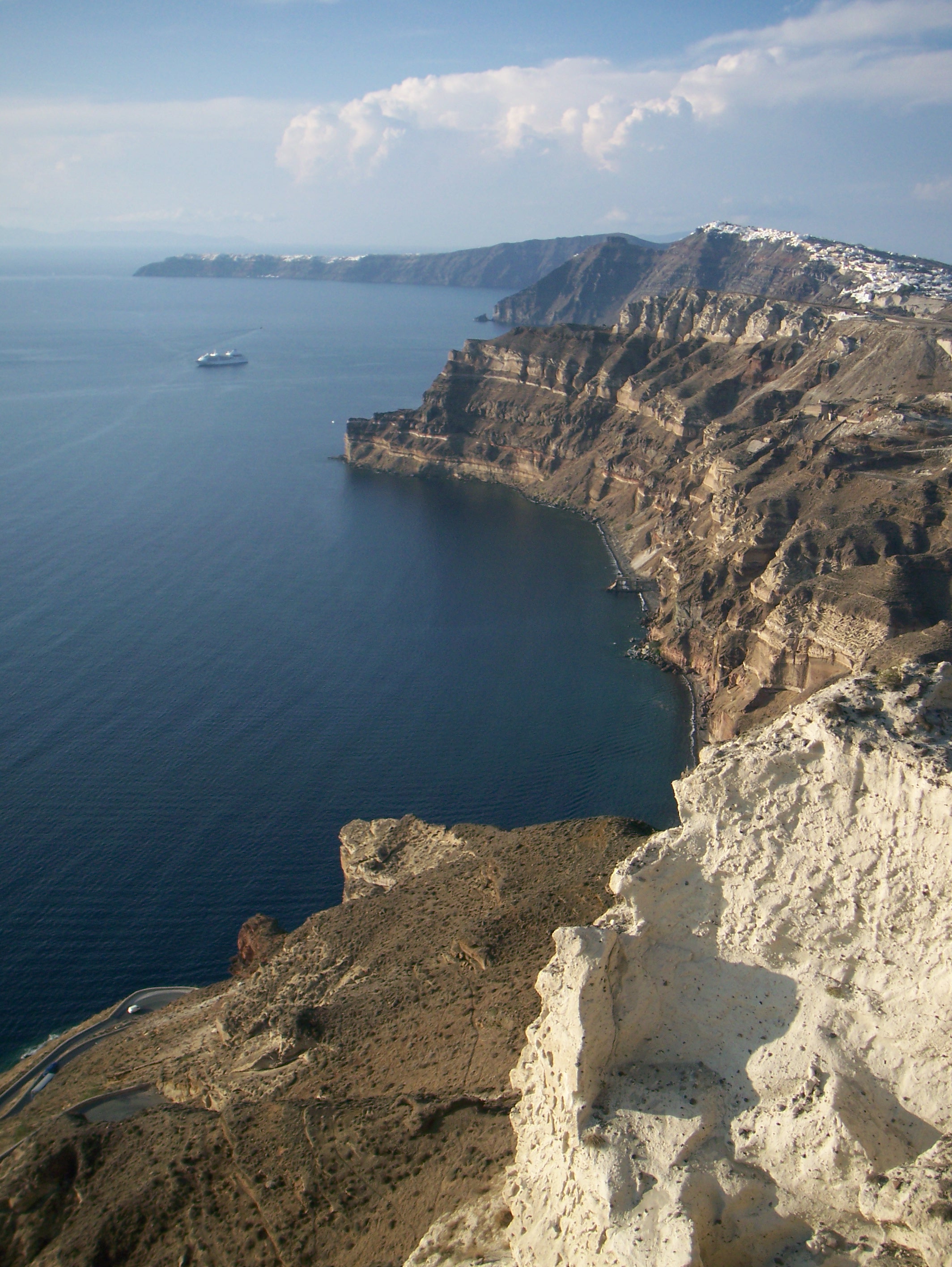
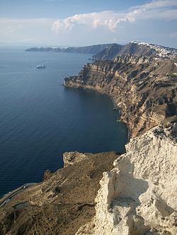 The cliffs in Santorini Island, Greece
Aegean surface water circulates in a counter-clockwise gyre, with hypersaline Mediterranean water moving northward along the west coast of Turkey, before being displaced by less dense Black Sea outflow. The dense Mediterranean water sinks below the Black Sea inflow to a depth of 23–30 metres (75–98 ft), then flows through the Dardanelles Strait and into the Sea of Marmara at velocities of 5–15 cm/s. The Black Sea outflow moves westward along the northern Aegean Sea, then flows southwards along the east coast of Greece.[3]
The physical oceanography of the Aegean Sea is controlled mainly by the regional climate, the fresh water discharge from major rivers draining southeastern Europe, and the seasonal variations in the Black Sea surface water outflow through the Dardanelles Strait.
Analysis[4] of the Aegean during 1991 and 1992 revealed 3 distinct water masses:
- Aegean Sea Surface Water – 40–50 metres (130–160 ft) thick veneer, with summer temperatures of 21–26 °C and winter temperatures ranging from 10 °C (50 °F) in the north to 16 °C (61 °F) in the south.
- Aegean Sea Intermediate Water – Aegean Sea Intermediate Water extends from 40–50 m to 200–300 metres (660–980 ft) with temperatures ranging from 11–18 °C.
- Aegean Sea Bottom Water – occurring at depths below 500–1000 m with a very uniform temperature (13–14 °C) and salinity (39.1–39.2%).
Etymology
In ancient times, there were various explanations for the name Aegean. It was said to have been named after the Greek town of Aegae, or after Aegea, a queen of the Amazons who died in the sea, or Aigaion, the "sea goat", another name of Briareus, one of the archaic Hecatonchires, or, especially among the Athenians, Aegeus, the father of Theseus, who drowned himself in the sea when he thought his son had died.
A possible etymology is a derivation from the Greek word αἶγες – aiges = "waves" (Hesychius of Alexandria; metaphorical use of αἴξ (aix) "goat"), hence "wavy sea", cf. also αἰγιαλός (aigialos = aiges (waves) + hals (sea)),[5] hence meaning "sea-shore".
History
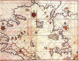 Historic map of Aegean Sea by Piri Reis
The current coastline dates back to about 4000 BC. Before that time, at the peak of the last ice age (c. 16,000 BC) sea levels everywhere were 130 metres lower, and there were large well-watered coastal plains instead of much of the northern Aegean. When they were first occupied, the present-day islands including Milos with its important obsidian production were probably still connected to the mainland. The present coastal arrangement appeared c. 7000 BC, with post-ice age sea levels continuing to rise for another 3,000 years after that.[6]
The subsequent Bronze Age civilizations of Greece and the Aegean Sea have given rise to the general term Aegean civilization. In ancient times, the sea was the birthplace of two ancient civilizations – the Minoans of Crete and the Mycenean Civilization of the Peloponnese.[7]
Later arose the city-states of Athens and Sparta among many others that constituted the Athenian Empire and Hellenic Civilization. Plato described the Greeks living round the Aegean "like frogs around a pond".[8] The Aegean Sea was later invaded by the Persians and the Romans, and inhabited by the Byzantine Empire, the Bulgarians, the Venetians, the Genoeses, the Seljuq Turks, and the Ottoman Empire. The Aegean was the site of the original democracies, and its seaways were the means of contact among several diverse civilizations of the Eastern Mediterranean.
Economics and politics
Many of the islands in the Aegean have safe harbours and bays. In ancient times, navigation through the sea was easier than travelling across the rough terrain of the Greek mainland (and to some extent the coastal areas of Anatolia). Many of the islands are volcanic, and marble and iron are mined on other islands. The larger islands have some fertile valleys and plains. Of the main islands in the Aegean Sea, two belong to Turkey – Bozcaada (Tenedos) and Gökçeada (Imbros); the rest belong to Greece. Between the two countries, there are political disputes over several aspects of political control over the Aegean space, including the size of territorial waters, air control and the delimitation of economic rights to the continental shelf.
See also
- Aegean languages
- List of traditional Greek place names
- Thracian Sea
References
[p] ^ The word "Aegean" is pronounced "i-Jee-en".[9]
- ^ Ege Denizinin Orijinal Adı Nedir?, Turkish Naval Force web site (in Turkish)
- ^ "Limits of Oceans and Seas, 3rd edition". International Hydrographic Organization. 1953. http://www.iho-ohi.net/iho_pubs/standard/S-23/S23_1953.pdf. Retrieved 7 February 2010.
- ^ Aksu, A. E., D. Yasar, et al. (1995). "LATE GLACIAL-HOLOCENE PALEOCLIMATIC AND PALEOCEANOGRAPHIC EVOLUTION OF THE AEGEAN SEA – MICROPALEONTOLOGICAL AND STABLE ISOTOPIC EVIDENCE." Marine Micropaleontology 25(1): 1–28.
- ^ Yagar, D., 1994. Late glacial-Holocene evolution of the Aegean Sea. Ph.D. Thesis, Inst. Mar. Sci. Technol., Dokuz Eyltil Univ., 329 pp. (Unpubl.)
- ^ Entry αἰγιαλός at LSI
- ^ Tjeerd H. van Andel and Judith C. Shackleton, Late Paleolithic and Mesolithic Coastlines of Greece and the Aegean, Journal of Field Archaeology, Vol. 9, No. 4 (Winter, 1982), pp. 445–454
- ^ Tracey Cullen, Aegean Prehistory: A Review (American Journal of Archaeology. Supplement, 1); Oliver Dickinson, The Aegean Bronze Age (Cambridge World Archaeology).
- ^ The familiar phrase giving rise to the title Prehistorians Round the Pond: Reflections on Aegean Prehistory as a Discipline, by John F. Cherry, Despina Margomenou, and Lauren E. Talalay.
- ^ "Aegean islands - Definition and More", Merriam-Webster.com, 2011, web:MWaegean.
External links
Articles on the Aegean Sea GeneralCountries Other Cyclades Amorgos · Anafi · Andros · Antimilos · Antiparos · Delos · Despotiko · Donoussa · Folegandros · Gyaros · Ios · Irakleia · Kardiotissa · Kea · Keros · Kimolos · Koufonisia · Kythnos · Milos · Mykonos · Nata · Naxos · Paros · Polyaigos · Rineia · Santorini · Schoinoussa · Serifopoula · Serifos · Sifnos · Sikinos · Syros · Therasia · Tinos · VousDodecanese Agathonisi · Arkoi · Armathia · Alimia · Astakida · Astypalaia · Çatalada · Chalki · Chamili · Farmakonisi · Gaidaros · Gyali · Imia/Kardak · Kalolimnos · Kalymnos · Kandelioussa · Kara Ada · Karpathos · Kasos · Kinaros · Kos · Küçük Tavşan Adası · Leros · Lipsi · Lebynthos · Nimos · Nisyros · Patmos · Pacheia · Platy · Pserimos · Rhodes · Saria · Salih Ada · Symi · Syrna · Telendos · Tilos · ZaforaNorth Aegean Agios Eustratius · Ammouliani · Ayvalık Islands · Büyük Ada · Chios · Chryse · Cunda · Foça Islands · Fournoi Korseon · Icaria · Imbros · Koukonesi · Lemnos · Lesbos · Metalik Ada · Nissiopi · Oinousses · Psara · Samiopoula · Samos · Samothrace · Tenedos · Thasos · ThymainaSaronic Sporades Adelfoi Islets · Agios Georgios Skopelou · Alonnisos · Argos Skiathou · Dasia · Erinia · Gioura · Grammeza · Kyra Panagia · Lekhoussa · Peristera · Piperi · Psathoura · Repio · Rineia Skyrou · Sarakino · Skandili · Skantzoura · Skiathos · Skopelos · Skyropoula · Skyros · Tsougria · ValaxaCretan Afendis Christos · Agia Varvara · Agioi Apostoloi · Agioi Pandes · Agioi Theodoroi · Agios Nikolaos · Anavatis · Arnaouti · Aspros Volakas · Avgo · Crete · Daskaleia · Dia · Diapori · Dionysades · Elasa · Ftena Trachylia · Glaronisi · Gramvousa · Grandes · Kalydon (Spinalonga) · Karavi · Karga · Katergo · Kavallos · Kefali · Kolokythas · Koursaroi · Kyriamadi · Lazaretta · Leon · Mavros · Mavros Volakas · Megatzedes · Mochlos · Nikolos · Palaiosouda · Peristeri · Peristerovrachoi · Petalida · Petalouda · Pontikaki · Pontikonisi · Praso Kissamou · Prosfora · Pseira · Sideros · Souda · Valenti · Vryonisi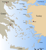
Other Earth's oceans and seas Arctic Ocean - Amundsen Gulf
- Barents Sea
- Beaufort Sea
- Bering Strait
- Chukchi Sea
- East Siberian Sea
- Fram Strait
- Greenland Sea
- Gulf of Boothia
- Kara Sea
- Kara Strait
- Laptev Sea
- Lincoln Sea
- Prince Gustav Adolf Sea
- Pechora Sea
- Wandel Sea
- White Sea
Atlantic Ocean - Adriatic Sea
- Aegean Sea
- Alboran Sea
- Archipelago Sea
- Argentine Sea
- Baffin Bay
- Balearic Sea
- Baltic Sea
- Bay of Biscay
- Bay of Bothnia
- Bay of Campeche
- Bay of Fundy
- Black Sea
- Bothnian Sea
- Caribbean Sea
- Celtic Sea
- Davis Strait
- Denmark Strait
- English Channel
- Foxe Basin
- Greenland Sea
- Gulf of Bothnia
- Gulf of Finland
- Gulf of Lion
- Gulf of Guinea
- Gulf of Mexico
- Gulf of St. Lawrence
- Gulf of Venezuela
- Great Lakes
- Hudson Bay
- James Bay
- Ionian Sea
- Irish Sea
- Irminger Sea
- Labrador Sea
- Levantine Sea
- Libyan Sea
- Ligurian Sea
- Marmara Sea
- Mediterranean Sea
- Myrtoan Sea
- North Sea
- Norwegian Sea
- Saint Lawrence Seaway
- Sargasso Sea
- Sea of Åland
- Sea of Azov
- Sea of Crete
- Sea of the Hebrides
- Thracian Sea
- Tyrrhenian Sea
Indian Ocean Pacific Ocean - Arafura Sea
- Bali Sea
- Banda Sea
- Bering Sea
- Bismarck Sea
- Bohai Sea
- Bohol Sea
- Camotes Sea
- Celebes Sea
- Ceram Sea
- Chilean Sea
- Coral Sea
- East China Sea
- Flores Sea
- Gulf of Alaska
- Gulf of California
- Gulf of Carpentaria
- Gulf of Thailand
- Gulf of Tonkin
- Halmahera Sea
- Java Sea
- Koro Sea
- Makassar Strait
- Molucca Sea
- Moro Gulf
- Philippine Sea
- Salish Sea
- Savu Sea
- Sea of Japan
- Sea of Okhotsk
- Seto Inland Sea
- Sibuyan Sea
- Solomon Sea
- South China Sea
- Sulu Sea
- Tasman Sea
- Visayan Sea
- Yellow Sea
Southern Ocean - Amundsen Sea
- Bellingshausen Sea
- Cooperation Sea
- Cosmonauts Sea
- Davis Sea
- D'Urville Sea
- King Haakon VII Sea
- Lazarev Sea
- Riiser-Larsen Sea
- Mawson Sea
- Ross Sea
- Scotia Sea
- Somov Sea
- Weddell Sea
Landlocked seas - Related navpages:
- {{Ancient Greece topics}}
Categories:- Aegean Sea
- Landforms of Greece
- Landforms of Turkey
- Seas of the Mediterranean
- European seas


Wikimedia Foundation. 2010.