- Darlinghurst, New South Wales
-
Darlinghurst
Sydney, New South Wales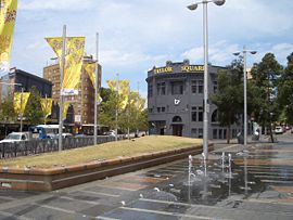
Taylor SquarePopulation: 10,128 (2006 census) • Density: 11470.0/km² (29,707.2/sq mi) Postcode: 2010 Area: 0.8 km² (0.3 sq mi) Location: 1 km (1 mi) east of Sydney CBD LGA: City of Sydney State District: Sydney Federal Division: Wentworth, Sydney Suburbs around Darlinghurst: Sydney CBD Woolloomooloo Potts Point Sydney CBD Darlinghurst Kings Cross Surry Hills Paddington Paddington Darlinghurst is an inner-city, eastern suburb of Sydney, in the state of New South Wales, Australia. Darlinghurst is located immediately east of the Sydney central business district and Hyde Park, within the local government area of the City of Sydney.[1] Darlinghurst is colloquially known as Darlo.
Darlinghurst is a densely populated suburb with the majority of residents living in apartments or terraced houses. Once a slum and red-light prostitution district, Darlinghurst has undergone urban renewal since the 1980s to become a rather upmarket, cosmopolitan and diverse area. Places such as Victoria Street (which joins Darlinghurst and Kings Cross) are known as culturally rich destinations.[citation needed] The main thoroughfare of Darlinghurst is considered to be Oxford Street which is well-known[citation needed] around the world as the centre of Sydney's gay community, and is home to a number of gay venues. In recent years, Oxford Street has garnered a reputation as being Sydney's primary "nightclub strip", popular with both gay and straight clubbers, and surpassing the notorious red-light district of Kings Cross in popularity. Subsequently, crime rates increased in the area, particularly for assaults and robberies.[2]
East Sydney is a locality in the western part of the suburb; Taylor Square is another locality within the suburb. Kings Cross is a locality on the northern border. Darlinghurst is surrounded by the suburbs of Woolloomooloo, Potts Point, Rushcutters Bay, Paddington and Surry Hills.
Contents
History
The suburb was originally known as Eastern Hill and then Henrietta Town, after Governor Lachlan Macquarie's wife, whose second name was Henrietta. The loyalties changed with the change of governors and the suburb became Darlinghurst in honour of Elizabeth Darling, the popular wife of Governor Ralph Darling, during the early 19th century. The 'hurst' is an old English word for a wooded area.[3]
Landmarks
 Darlinghurst Gaol, 1930
Darlinghurst has two of Sydney's museums: the Australian Museum (a natural history museum) and the Sydney Jewish Museum. The suburb also features St Vincent's Hospital, and is associated with the Sacred Heart Hospice on Darlinghurst Rd, and the Garvan Institute of Medical Research.
Darlinghurst Gaol
Darlinghurst Gaol, the large sandstone penal complex in the middle of Darlinghurst was built between 1836 and 1840. The large sandstone walls still bear convict markings, and the complex features six wings surrounding a circular chapel. Australian poet Henry Lawson spent time incarcerated here during some of the turbulent years of his life. The last hanging at the gaol was in 1907 (Jahn, 1997). The site became East Sydney Technical College in 1921, but was turned into the National Art School from 1995.
Darlinghurst Fire Station
Completed in 1912, this three-storey brick and stone building occupies a prominent location at the corner of Darlinghurst Road and Victoria Street. It was designed in 1910 by Walter Liberty Vernon (Jahn, 1997). It still functions as a fire station and is listed on the Register of the National Estate.
Darlinghurst Courthouse
 Darlinghurst Court House, Taylor Square (listed on the National Estate)
Darlinghurst Courthouse is an imposing sandstone building on Taylor Square. It was designed by architect Mortimer Lewis (1796–1879) in 1844, and has a Greek Revival style facade. The central block is adapted from an 1823 design in Peter Nicholson's 'The New Practical Builder' (Apperly, Irving & Reynolds, 1989).
Oxford Street
Oxford St is the major commercial street of Darlinghurst, running from the south-east corner of Hyde Park, through to Taylor Square and beyond through Paddington, Woollahra and Bondi Junction. Oxford St was originally called the South Head Road, and work was commenced on the road in 1811 (Faro, 2000). It was a toll road in its early years with the toll gates being located near present day Glenmore Road. Oxford St assumed its current name in 1875. Oxford Square is located at the intersection of Oxford Street and Burton Street. Oxford Square is also the name of the small shopping centre located opposite, at the corner of Oxford Street and Riley Street. [4]
Stanley Street
Stanley Street is one of the suburb's two secondary restaurant strips (with Victoria Street) and is often referred to as Sydney's first "Little Italy". However, the restaurants range from Japanese, Thai and Italian and the prices range from basic to moderate. There is an annual Italian Festival held here every June.
Victoria Street
Victoria Street is the other major cafe strip. Restaurants range from basic to upmarket. The majority of the cafes have outdoor seating. Several iconic restaurants are in this area, such as Tropicana and Bar Coluzzi.
Inter-War apartments
 Horizon Apartments
Kurrajong, 138 Darlinghurst Road,Darlinghurst
Mont Clair, 347 Liverpool Street, Darlinghurst
Royal Court, 227 Crown Street, Darlinghurst
The Rutland, 381 Liverpool Street, Darlinghurst
Hillcrest, 114 Burton Street, Darlinghurst
The Savoy, 2-10 Hardy Street, Darlinghurst
Claridge, 28-30 Flinders Street, Darlinghurst
Ballina, 3-5 Darley Street, Darlinghurst
Portree, 2a Darley Street, DarlinghurstThe Horizon
The Horizon, located in Forbes Street, Darlinghurst, is a 43-storey residential high rise building completed in 1998. It has a distinctive scalloped facade and is finished in rendered concrete. The building was designed by Sydney architect, Harry Seidler and is controversial in that it has caused major overshadowing of the surrounding area.
Commercial area
Darlinghurst's commercial activity is centred on Oxford Street, and extends to Victoria Street, Flinders Street, Crown Street, Cleveland Street, and Darlinghurst Road. There are a large number of cafés, restaurants and take-away food stores throughout Darlinghurst, as well as a large number of pubs and nightclubs, many of which are on Oxford Street. There is also a significant retail presence, including fashion retailers.
Transport
Darlinghurst is well-served by public transport, with many bus routes from the Eastern Suburbs converging on Oxford Street prior to entering the central business district. The 380 bus between Circular Quay and Bondi Beach travels through Darlinghurst along Oxford Street. The 333 bus runs the same route but is an express service, only servicing major stops and all passengers must have prepaid tickets. The 378 bus between Railway Square and Bronte also travels through Darlinghurst along Oxford Street. The 392, 394, 396 and 399 buses also travel through the suburb on Oxford Street. Buses that travel through the centre of Darlinghurst are the 311 and the 389 buses.
There are no train stations in Darlinghurst, however Kings Cross railway station on the CityRail Eastern Suburbs and Illawarra line is just over the northern border of the suburb. Museum station on the City Circle, is located just to the west of Darlinghurst, on the south-west corner of Hyde Park.
Schools
 Diana Bowman Performing Arts Centre (SCEGGS)
Darlinghurst Public School, located on Womerah Avenue, was opened in 1884. The Sydney Grammar School is located on College Street, across the road from Hyde Park. This school is a boys-only private school which opened in 1857.
The Sydney Church of England Girls' Grammar School (now called SCEGGS Darlinghurst) was founded in 1895 in Victoria Street, Darlinghurst. It moved to its current site in Forbes Street, in 1901. The former Marist College on Liverpool Street is now an apartment complex.
The National Art School of Australia, a specialist Art school in collaboration with Sydney TAFE, dates back to 1859.
The Notre Dame School of Medicine, Sydney is located in the historic parish buildings associated with the Sacred Heart Parish in Darlinghurst. The complex includes state of the art facilities for use by medical students such as simulated wards, practise wet laboratories and clinical skills laboratories in addition to simulated consulting rooms.
Churches
 Heritage-listed Christian Science Church
Darlinghurst has three functioning churches: God in the City, an Assemblies of God congregation affiliated with Christian City Churches; St. Pauls Lutheran congregation; St. John the Evangelist, an Anglican congregation; and the Church of Christ, Scientist. On 10 April 2010, the Sydney Morning Herald reported that the congregation of the Church of Christ, Scientist, had enlisted a real estate agent to sell the church. In 2011 the Church of Science was sold to a developer and is currently being remodeled into apartments.
St. Johns operates Rough Edges, a street outreach centre that functions as a cafe and drop-in centre. It provides a range of services to the local community, including the homeless. There is also a variety of smaller chapels and religious services attached to St Vincent's Hospital and other religious organisations in the suburb. The Sacred Heart Church on the corner of Darlinghurst Rd and Oxford St, a Catholic church, is part of a site redevelopment which involves a campus of the Notre Dame University on its site.
There is also the defunct St. Peter's Anglican church, Bourke Street, which is now part of SCEGGS Darlinghurst.
Politics
The area has often been a battleground between the two councils of the City of Sydney and the City of South Sydney. Most of the suburb belonged to South Sydney, however the New South Wales State Government moved the borders repeatedly in order to change the make-up of the city of Sydney. Many claim that these shifts have been attempted to shift the balance of power in the favour of the party in control of the State Government.
This battle has become a moot point however, with the two councils forced to amalgamate in February 2004 by the State Government. An election was held on Saturday, 27 March 2004, in order to elect a new council for the new (expanded) city of Sydney. Critics of the amalgamation have claimed that the election demonstrated strong voter backlash against the State Government for pressing the issue. The Australian Labor Party, for whom the area was usually safe, had their primary vote reduced to approximately 20%. The independent Clover Moore took the Lord Mayoral position, having campaigned against the Government's dismissal of the Council.
At a federal level, Darlinghurst falls in the electorates of the Division of Sydney and Wentworth. Its current parliamentary representatives are Tanya Plibersek (Labor) and Malcolm Turnbull (Liberal). These electorates have some of the state's strongest support for The Greens.
Heritage
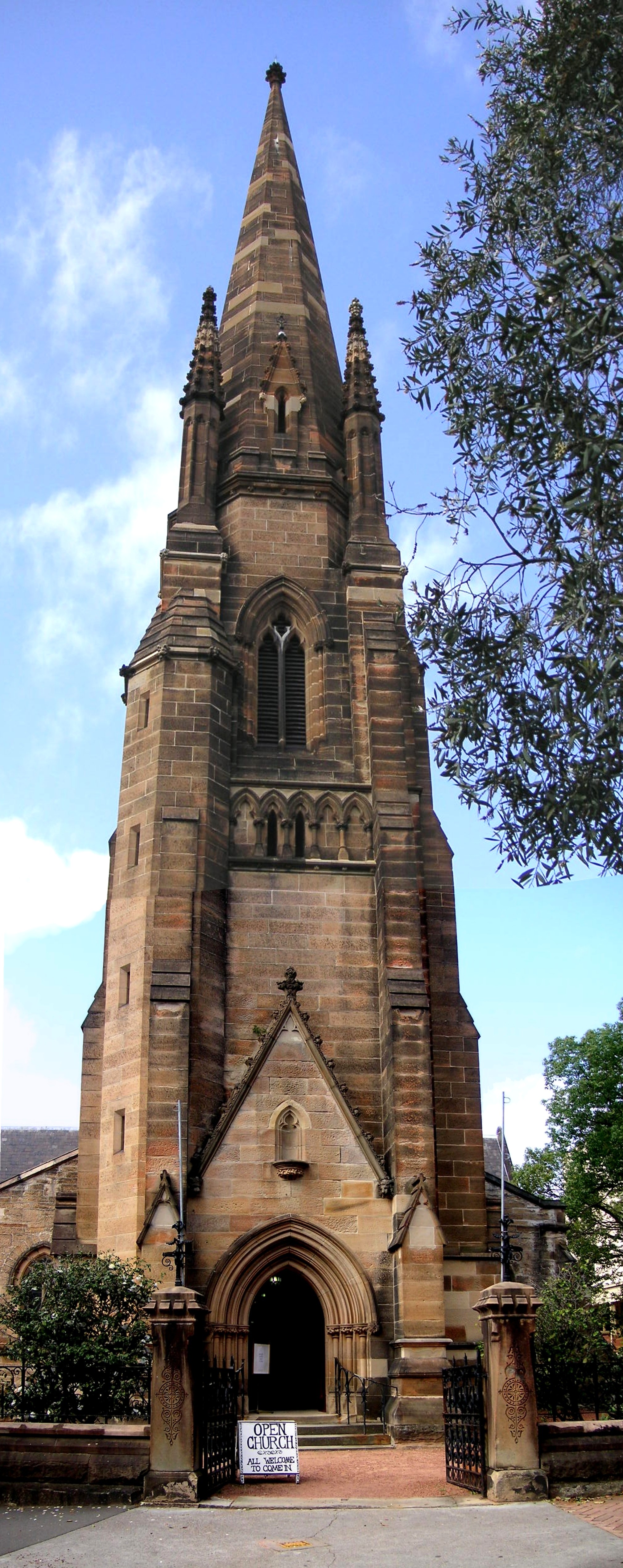
 St John's Church of England
The following buildings are listed on the Register of the National Estate.[5]
- St Peter's Church of England, Bourke Street
- Beare's Stairs, Caldwell and Surry Streets
- Hilton, Liverpool Street
- Former Marist Brothers High School, corner Liverpool and Darley Streets
- Stoneleigh, Darley Street
- Hughlings Private Hospital, Darley Street
- Novar, Darley Street
- The Grange, Liverpool Street
- St John's Church of England and Church Rectory, Darlinghurst Road
- National Art School (formerly Darlinghurst Gaol), Forbes and Burton Streets
- Barham, SCEGGS School, Forbes Street
- St Peter's Rectory, Forbes Street
- Former Belgrave Terrace, Forbes Street
- Terrace, 204-218 Liverpool Street
- Terrace, 337-345 Liverpool Street
- SILF Company Building, 10-20 Oxford Square
- Former Family Hotel, 20 Burton Street
- Former ANZ Bank, 52 Oxford Street
- G.A.Zink and Sons, 56 Oxford Street
- Presbyterian Church and Manse, Palmer and Stanley Streets
- Darlinghurst Court House, Taylor Square
- Former Police Station, Forbes Street, Taylor Square
- Darlinghurst Fire Station, corner Darlinghurst Road and Victoria Street
- Darlinghurst Public School, Womerah Avenue
Culture
The area is most famous for the annual Sydney Gay and Lesbian Mardi Gras. The parade which marks the end of this festival takes place on Oxford Street, the main street that runs through several suburbs, including Darlinghurst.
References
- ^ Gregory's Sydney Street Directory, Gregory's Publishing Company, 2007
- ^ Heath Aston."Oxford St beset with violence
- ^ The Book of Sydney Suburbs, Compiled by Frances Pollen, Angus & Robertson Publishers, 1990, Published in Australia ISBN 0-207-14495-8, page 77
- ^ Clive Faro & Garry Wotherspoon: Street Seen: A History Of Oxford Street. . Published by Melbourne University Press. Australia, 2000 ISBN 0 522 48966 0)
- ^ The Heritage of Australia, Macmillan Company, 1981
- Apperly, Richard; Irving, Robert; Reynolds, Peter (1989). A Pictorial Guide to Identifying Australian Architecture: Styles and Terms from 1788 to the Present. Sydney, Angus & Robertson. ISBN 0-207-18562-X
- Faro, Clive (2000). Street Seen: A History of Oxford St. Carlton South, Melbourne University Press. ISBN 0-522-84967-9
- Jahn, Graham (1997). Sydney Architecture. Sydney, The Watermark Press. ISBN 0-949284-32-7
External links
Coordinates: 33°53′00″S 151°13′30″E / 33.8833°S 151.2250°E
Suburbs and localities within the City of Sydney Suburbs Alexandria · Annandale · Barangaroo · Beaconsfield · Camperdown · Centennial Park · Chippendale · Darlinghurst · Darlington · Dawes Point · Elizabeth Bay · Erskineville · Eveleigh · Forest Lodge · Glebe · Haymarket · Millers Point · Moore Park · Newtown · Paddington · Potts Point · Pyrmont · Redfern · Rosebery · Rushcutters Bay · Surry Hills · Sydney CBD · The Rocks · Ultimo · Waterloo · Woolloomooloo · Zetland
Localities Categories:- Suburbs of Sydney
- Gay villages in Australia
- Entertainment districts


Wikimedia Foundation. 2010.