- U.S. Route 395
Infobox road
type=US
route=395
marker_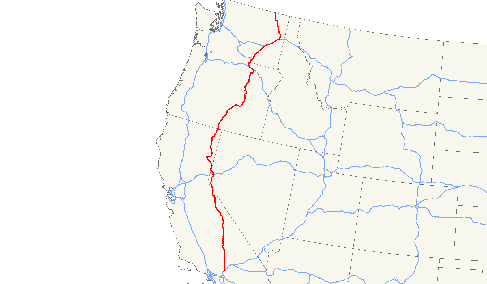
length_mi=1305
length_round=0
length_ref=
established=1926
direction_a=South
terminous_a=jct|state=CA|I|15 in Hesperia, CA
junction=jct|state=CA|US|6 in Bishop, CA
jct|state=NV|US|50 in Carson City, NV
jct|state=NV|I|80 in Reno, NV
jct|state=OR|US|20 in Burns, OR
jct|state=OR|I|84|US|30 in Pendleton, OR
jct|state=WA|I|82 in Tri-Cities, WA
jct|state=WA|I|90|US|2 in Spokane, WA
direction_b=North
terminus_b=Jct|state=BC|Hwy|395 atUS-Canada border near Laurier, WA
spur_of=95U.S. Route 395 is a
U.S. Route in the westernUnited States . The southern terminus of the route is in theMojave Desert at Interstate 15 near Hesperia. The northern terminus is at the Canadian border near Laurier, where the road becomes Highway 395 upon enteringBritish Columbia . At one time, the route extended south to San Diego.The route runs through the
U.S. state s ofCalifornia ,Nevada ,Oregon , andWashington . US 395 runs along the east side of the Sierra Nevada in theOwens Valley and crosses through theModoc Plateau along its routing.Route description
California
US-395 begins in the
Mojave Desert community of Hesperia at the junction with Interstate 15. The highway proceeds northwest across the Mojave Desert until merging with Route 14, which formerly was the south end of a concurrent run with U.S. Route 6. From here to Bishop the highway follows the easternescarpment of the Sierra Nevada mountain range. For most of this run the highway is also routed through theOwens Valley . While in this stretch US 395 has distant views of both the highest point in thecontiguous United States ,Mount Whitney and the lowest point in North America,Death Valley .cite map
publisher=Benchmark Maps
title=Nevada Road and Recreation Atlas
url=http://www.benchmarkmaps.com
edition=2003
year=2003
scale=1:250000
page=70
section = B2
isbn=0-929591-81-X]After Bishop the scenery dramatically changes as the highway ascends the Sierra Nevada, serving the ski resort town of
Mammoth Lakes, California andMammoth Mountain as well asMono Lake andJune Lake . The highway exits California atTopaz Lake to serve theReno, Nevada metropolitan area.The highway returns to California just north of Reno. This northern piece also follows the Sierra Nevada. It passes through the towns of Susanville and Alturas, also serves several points of interest along this portion, such as the
Hallelujah Junction ,Honey Lake , and theModoc Plateau .Nevada
U.S. 395 in Nevada is a major highway, the majority of which is now or is scheduled to be upgraded to
Interstate Highway standards . The portion from Carson City to Reno is also designated as Interstate 580 but is not signed as such, except on mile markers (US 395 mile markers can be seen alongside Virginia Street from Lemmon Valley to Mount Rose Highway). The highway follows the eastern edge of the Sierra Nevada from state line to state line.U.S. 395 enters Nevada at
Topaz Lake then descends toCarson Valley where it becomes the main streets of Gardnerville, Minden and Carson City. In Reno the highway is designated theMartin Luther King, Jr. Freeway. The highway returns to California just north of Reno at Bordertown.Oregon
US 395 enters
Oregon at New Pine Creek, then heads north to Lakeview. At Lakeview, it overlapsOregon Route 140 for five miles, then continues to north to Valley Falls. At Valley Falls, it turns northeast through Wagontire to Riley. Near Riley, US 395 overlaps US 20 through Hines and Burns. Approximately two miles northeast of Burns, US 395 turns north through Seneca and Canyon City to John Day. At John Day, it overlaps US 26 and heads west to Mount Vernon. At Mount Vernon, US 395 turns north through Long Creek and Pilot Rock to Pendleton. At Pendleton, it overlaps Interstate 84 and US 30 west to Stanfield. At Stanfield, US 395 turns north through Hermiston to Umatilla. East of Umatilla, it overlaps US 730 and heads west to Interstate 82. It then overlaps I-82 to theWashington state line at theColumbia River .Washington
US-395 enters
Washington withI-82 over theColumbia River . At exit 113, US 395 splits from I-82, entering the Tri-Cities area. After departing the freeway, it passes residential areas south of Kennewick. After that there is astoplight at 27th Avenue. The next major intersection is at 10th next toFred Meyer , then at West Kennewick Avenue, followed by the intersections at West Clearwater Avenue and North Yelm Street, then heads toward theColumbia River . It then passes over the Columbia River as the Blue Bridge with a view of theCable Bridge (WA-397) to the east as it proceeds towardI-182 /US-12 . The Blue Bridge has often traffic backups, especially during rush hour. US 395 joins I-182 for a short distance to Pasco, where it separates from the freeway. Past I-182, it passes the Tri-Cities Airport before resuming a north/south direction at the Oregon Avenue interchange. Outside of Pasco, US 395 crosses through farmland and little towns until it combines withI-90 at the town ofRitzville . From there it goes to Spokane (US-2 merges into I-90/US-395 as they enter the city) and splits from I-90 at the Division Street exit.US 395 currently runs north on Division Street to travel through Spokane. WSDOT is constructing the US 395 North Spokane Corridor, which is a completely new freeway that will run from I-90 (around the Thor/Freya exit) northward to the existing US 395 north of Wandermere. Construction on the new freeway began between Wandermere and Francis in 2003. The freeway will take many years to complete due to funding.
US-395 (along with US-2) proceed north through Spokane as Division Street to the north edge of the city where they split (US-2 heading Northeast to Idaho). US-395 then proceeds north to the Canadian border.
History
US Highway 395 once extended to downtown San Diego. This part of the highway is now the alignments of Interstate 15 from Hesperia to Devore and Interstate 215 from Devore to Temecula where it meets Interstate 15 again. From Temecula the old route follows Interstate 15 again to east of Fallbrook where the original US 395 still exists as a frontage road. "Old US 395" can be followed from north of State Route 76 through Escondido where it meets Interstate 15 again. Finally, State Route 163, the old routing of US 395, splits off Interstate 15 at the south end of Miramar and follows the Cabrillo Freeway into downtown San Diego.
References
External links
* [http://www.geocities.com/mapguy_annex/HwyEnds/End395/end395.htm Endpoints of US highways]
* [http://www.floodgap.com/roadgap/395/ The Three Flags Highway: US 395 at Floodgap Roadgap]
Wikimedia Foundation. 2010.