- Chaudes-Aigues
-
Chaudes-Aigues
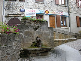
Source of the Par and museum 

 Chaudes-Aigues
Administration Country France Region Auvergne Department Cantal Arrondissement Saint-Flour Canton Chaudes-Aigues Intercommunality Caldaguès-Aubrac Mayor Madeleine Baumgartner
(2008–2014)Statistics Elevation 637–1,280 m (2,090–4,200 ft)
(avg. 750 m/2,460 ft)Land area1 53.16 km2 (20.53 sq mi) Population2 954 (2008) - Density 18 /km2 (47 /sq mi) INSEE/Postal code 15045/ 15110 1 French Land Register data, which excludes lakes, ponds, glaciers > 1 km² (0.386 sq mi or 247 acres) and river estuaries. 2 Population without double counting: residents of multiple communes (e.g., students and military personnel) only counted once. Coordinates: 44°51′19″N 3°00′17″E / 44.8552777778°N 3.00472222222°E
Chaudes-Aigues (IPA: [ʃodzɛg]; Occitan: Chaudas Aigas) is a commune in the Cantal department in south-central France. It is a spa town, famous for its hot spring waters.
Contents
Geography
The commune is situated in the Massif Central in Aubrac. Its inhabitants are called the Caldaguès, from the Latin meaning 'hot waters', or in French, eaux chaudes; hence the name of the commune, Chaudes-Aigues
As its name suggests, there are thirty natural hot water sources with temperatures ranging from 45° to more than 80°. The most famous is the source of the Par river with a water temperature of 82° - the hottest in Europe - with a flow in the region of 450,000 litres a day. The odds are that the source so-named because a pig was dressed (paré) or jointed thanks to the hot water. The waters are used all year round. In winter, they provide heat for houses and the church; from spring the waters are channeled to the spa for the treatment of rheumatics.
The Remontalou stream crosses the commune.
Population
Historical population of Chaudes-Aigues 1962 1968 1975 1982 1990 1999 2008 1218 1114 1187 1186 1110 986 954 Sites
The Château de Couffour is a ruined castle, dating back to the 15th century, situated in the commune.
See also
References
External links
- Official site (French)
Categories:- Communes of Cantal
- Spa towns in France
- Cantal geography stubs


Wikimedia Foundation. 2010.