- Forest of Dean
-
This article is about the historic Forest. For the local authority, which covers a wider area, see Forest of Dean (district).
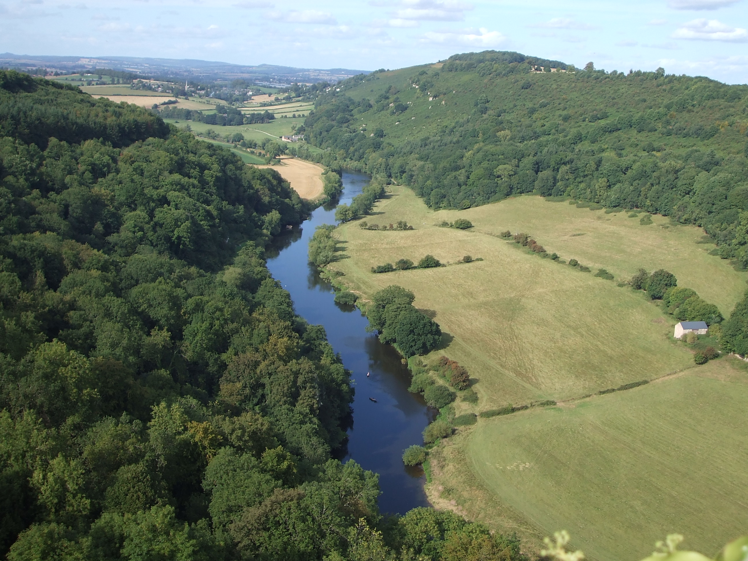
 The view north towards Ross-on-Wye from Symonds Yat Rock, a popular tourist destination in the Forest
The Forest of Dean is a geographical, historical and cultural region in the western part of the county of Gloucestershire, England. The forest is a roughly triangular plateau bounded by the River Wye to the west and north, the River Severn to the south, and the City of Gloucester to the east.
The area is characterised by over 110 square kilometres (42.5 sq mi) of mixed woodland, one of the surviving ancient woodlands in England. A large area was reserved for royal hunting before 1066, and remained as the second largest Crown forest in England, the largest being New Forest. Although the name is often used loosely to refer to that part of Gloucestershire between the Severn and Wye, the Forest of Dean proper has covered a much smaller area since mediaeval times. In 1327 it was defined to cover only the royal demesne and parts of parishes within the hundred of St Briavels,[1] and after 1668 the Forest comprised the royal demesne only. This area is now within the civil parishes of West Dean, Lydbrook, Cinderford, Ruspidge, and Drybrook.[2]
Traditionally the main sources of work in the area have been forestry – including charcoal production - iron working and coal mining. Archaeological studies have dated the earliest use of coal in the forest to Roman times, for domestic heating and industrial processes such as the preparation of iron ore.[3]
The area gives its name to the local government district, Forest of Dean, and a Parliamentary constituency, all of which cover wider areas than the historic Forest. The administrative centre of the local authority is Coleford which is also one of the main towns in the historic Forest area, together with Cinderford and Lydney.
Contents
Geology
See also: Geology of GloucestershireThe Forest of Dean is formed of a raised basin of palaeozoic rocks folded in the Variscan Orogeny, similar to the South Wales coalfield to the west. Underlain by great thicknesses of the Old Red Sandstone, the basin is filled with Carboniferous limestones, sandstones and coal measures, all of which have contributed to the industrial history of the region.
History
Prehistory
The area was inhabited in Mesolithic times,[4] and there are also remains of later megalithic monuments, including the Longstone[5] near Staunton and the Broadstone[6] at Wibdon, Stroat. Barrows have also been identified at Tidenham and Blakeney. Bronze Age field systems have been identified at Welshbury Hill near Littledean, and there are several Iron Age hill forts, notably those at Symonds Yat and Welshbury. There is also archaeological evidence of early trading by sea, probably through Lydney. Before Roman times, the area may have been occupied by the British Dobunni tribe, although few of their coins have been found in the area and control may have been contested with the neighbouring Silures.[7]
The Romans
The area was occupied by the Romans around 50 AD. They were attracted by the natural resources of the area, which included iron ore, ochre and charcoal. The coal mining industry was also probably established on a small scale in Roman times.[8] The area was governed from the Roman town of Ariconium at Weston under Penyard near Ross-on-Wye, and a road was built from there to a river crossing at Newnham on Severn and port at Lydney. The "Dean Road" still visible at Soudley is believed to be a mediaeval rebuilding of the Roman road, and would have been an important route for the transport of iron ore and finished metal products. During Roman times there were important Roman villas at Blakeney, Woolaston and elsewhere, and towards the end of the Roman period, around the year 370, a major Roman temple complex dedicated to the god Nodens was completed at Lydney. The central parts of the woodlands in the Forest are believed to have been protected for hunting since Roman times.[9]
The medieval period
 St. Briavels Castle
The history of the area is obscure for several centuries after the end of the Roman period during the so called Dark Ages, though at different times it may have been part of the Welsh kingdoms of Gwent and of Ergyng, and the Beachley and Lancaut peninsulas east of the Lower Wye remained in Welsh control at least until the 8th century.[7] Around 790 the Saxon king Offa of Mercia built his Dyke high above the Wye, to mark the boundary with the Welsh. The Forest of Dean then came under the control of the diocese of Hereford. Throughout the next few centuries Vikings conducted raids up the Severn, but by the 11th century the kingdom of Wessex had established civil government in the area.[2] The core of the forest was used by the late Anglo Saxon kings, and after 1066 the Normans, as their personal hunting ground. The area was kept stocked with deer and wild boar, but also became important for its timber, charcoal, iron ore and limestone. The name of the area originates at this time, probably derived from the dene, or valley, near Mitcheldean, with areas known as Dene Magna (large) and Dene Parva (small). The manor of Dean was the Forest's administrative centre in the late 11th century.
The Hundred of St. Briavels was established in the 12th century, at the same time as many of the Norman laws concerning the Forest of Dean were put in place. St. Briavels Castle became the Forest's administrative and judicial centre. Verderers were appointed to act for the king and protect his royal rights, and local people were given some common rights. Flaxley Abbey was also built and given certain rights and privileges. In 1296, miners from the Hundred of St Briavels were used by King Edward I at the siege of Berwick-on-Tweed in the Scottish Wars of Independence to undermine the town's defences and regain it from the Scots. As a result, the king granted free mining rights within the forest to them and their descendants; the rights continue to the present day. Miners at that time were mainly involved in iron mining. Although the presence of coal deposits in the district was well known and limited amounts of it had been recovered in Roman times, it was not practicable to use it for iron making with the methods of smelting then in use. However, later the freeminer rights were used mainly for coal mining.[2] The activities of the miners were regulated by the Court of Mine Law.[8]
The 16th - 18th centuries
The forest later went on to be used exclusively as a royal hunting ground by the Tudor Kings, and subsequently a source of food for the Royal Court. Its rich deposits of iron ore led to its becoming a major source of iron. Timber from the forest was particularly fine and was regarded as the best source for building ships.
The Speech House, between Coleford and Cinderford, was originally built in 1682 to host the Court of Mine Law and "Court of the Speech", a sort of parliament for the Verderers and Free Miners managing the forest, game, and mineral resources of the area.[10] The Gaveller and in latter times his Deputy were responsible for leasing gales - areas allocated for mining - on behalf of the Crown.[8] The Speech House has been used as an inn and hotel since the 19th century.
During the 18th century, squatters began to establish roughly-built hamlets around the fringes of the Crown forest demesne. By about 1800, these new settlements had become well established at places such as Berry Hill and Parkend.
The Forest of Dean, with its huge iron-ore reserves and ready supply of timber, had been an area of national importance in the production of iron, using charcoal, for hundreds of years.[11] Despite there also being extensive coal measures, the local coal did not produce coke that was ideal for smelting and local ironmasters were reluctant to invest in the new technology. It was not until the last decade of the 18th century that coke-fired furnaces began to make an appearance in the Forest, with Cinderford, Whitecliff and Parkend Ironworks being built almost simultaneously.[12]
The Dean Forest Riots
Main article: Warren JamesIn 1808 Parliament passed the Dean Forest (Timber) Act, which included the provision to enclose 11,000 acres (4,452 ha) of woodland. Between 1814 and 1816 all 11,000 acres (4,452 ha) were enclosed.[citation needed]
There were bread riots in 1795 and in 1801. Ordinary Foresters were already poverty stricken, and now their plight had grown worse. They were denied access to the enclosed areas and so were unable to hunt in them or remove timber. In particular, they lost their ancient grazing and mining rights.[citation needed]
There were large enclosure riots in 1831. Unrest was growing and Warren James emerged as a populist leader. Attempts to resolve the matter peaceably failed and on June 8, 1831, James, leading a group of over 100 foresters, proceeded to demolish the enclosure at Park Hill, between Parkend and Bream. Around 50 unarmed Crown Officers, were present, but powerless to intervene. On the Friday, a party of 50 soldiers arrived from Monmouth, but by now the number of Foresters had grown to around 2000 and the soldiers returned to their barracks. On Sunday a squadron of heavily armed soldiers arrived from Doncaster and the day after, another 180 infantrymen arrived from Plymouth.[citation needed]
The Foresters’ resistance soon crumbled and most of those arrested elected to voluntarily rebuild the enclosures, rather than be charged with rioting. James was sentenced to death, but this was later commuted to transportation. He was sent to Van Diemen’s Land (Tasmania) in October 1831, only to be pardoned five years later, although he never returned home.[13]
There was a political riot in 1874. Conservatives were disliked in the Forest of Dean and on the polling day of 1874 in the market town of Cinderford there was a riot in which the conservative's party headquarters and nearby houses were ransacked and damaged.[citation needed]
'Who killed the bears?'
On 26 April, 1889, four Frenchmen and their two bears were making their way to Ruardean, having performed in Cinderford. They were attacked by an angry mob, enraged by claims that the bears had killed a child and injured a woman. The bears were killed and the Frenchmen badly beaten.
It soon became clear that the bears had not attacked anyone. Police proceedings followed and a week later 13 colliers and labourers appeared before magistrates at Littledean, charged with ill-treating and killing the bears and assaulting the Frenchmen. All but two were found guilty on one or more charges, with another convicted a week later. A total of £85 was paid in fines - a huge sum in those days. A subscription was also launched which generously compensated the Frenchmen.
The term 'Who killed the bears?' existed for many years as an insult, directed particularly towards the people of Ruardean - despite the fact that all those convicted were from Cinderford.[14]
Industrial development in the 19th and early 20th centuries
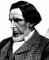 Robert Forester Mushet (1811-1891), steel industry pioneer
Exploitation of the Forest of Dean Coalfield developed rapidly in the early 19th century with increased demand from local ironworks, and when some of the earliest tramroads in the UK were built here to help transport the coal to local ports. The area was transformed by growth of mining and the production of iron and steel.
In 1818/9 David Mushet built a foundry at Darkhill, where he experimented with iron and steel making. In 1845, his youngest son, Robert Forester Mushet, took over management of the site. One his greatest achievements was to perfect the Bessemer Process by discovering the solution to early quality problems which beset the process.[15]
In a second key advance in metallurgy Mushet invented 'R Mushet's Special Steel' (R.M.S.) in 1868.[16] It was both the first true tool steel[16] and the first air-hardening steel.[17] It revolutionised the design of machine tools and the progress of industrial metalworking, and was the forerunner of High speed steel.
The remains of Darkhill are now preserved as an Industrial Archaeological Site of International Importance and are open to the public.[18]
Cinderford was laid out as a planned town in the mid-19th century, but the characteristic form of settlement remained the sprawling hamlets of haphazardly placed cottages. Characteristics shared with other British coalfields, such as a devotion to sport, the central role of miners' clubs, and the formation of brass bands, also helped to create a distinct community identity.[2]
In the later 19th century and the early 20th the Forest was a complex industrial region, including deep coal mines and iron mines, iron and tinplate works, foundries, quarries and stone-dressing works, wood distillation works producing chemicals, a network of railways, and numerous minor tramroads. The tradition of independence in the area resulted in a great number of smaller and therefore not necessarily economically successful mines. In 1904 the Gaveller oversaw a period of amalgamation of mines, which allowed deeper bigger mines to be sunk. During the early 20th century, annual output from the coalfield rarely fell below 1 million tons.[8]
Changes since the mid-20th century
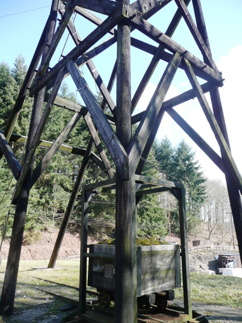
 Part of the pithead structure at Hopewell Colliery museum.
The importance of mining to the area is shown by the fact that as late as 1945 half of the male working population of the area worked in the coal industry. However after the Second World War increased pumping costs and other factors made the coalfield less economic. The last commercial iron mine in the district closed in 1946 and this was followed in 1965 by the closure of the last large colliery, Northern United.[8][19] There are still a number of small private mines in operation, worked by freeminers, with Hopewell Colliery now open to the public.
With the decline of the mines, the area has undergone a period of significant change, ameliorated to some extent by a shift to high technology, with companies establishing themselves in the area, attracted by grants and a willing workforce.
Many of the mines have now disappeared into the forest and today the area is characterised by picturesque scenery punctuated by remnants of the industrial age and small industrial towns. There remain a number of industrial areas but the focus in recent years has been to capitalise on the exceptional scenery and to create more jobs from tourist attractions and the leisure opportunities afforded by the forest. Significant numbers of residents also now work outside the area, commuting to the nearby cities of Gloucester, Bristol and Cardiff.
Foresters
If born within the hundred of St Briavels, an ancient administrative area covering most of what is now considered the Forest of Dean, one is classed as a true Forester. This classification bestows a unique right for (traditionally) males who are over 21 and have worked in a mine for a year and a day — they can register[20] to be a freeminer.[21] These ancient rights that were put on the statute books in the Dean Forest (Mines) Act 1838, the only public act to affect private individuals[citation needed].Residents of the hundred who are over 18 can also graze sheep in the Forest in accordance with an agreement between the Forestry Commission and the Commoners Association.
In October 2010, for the first time, a woman won the right to be classified as a Freeminer. Elaine Morman, an employee at Clearwell Caves in the Forest, who had worked as a miner of ochre for a number of years, raised a claim of sexual discrimination against the Forestry Commission. After Mark Harper MP raised the matter in the House of Commons, the Forestry Commission reversed its position and agreed to register her.[22][23]
Ecology
 A frozen Mallards Pike Lake.
The forest is composed of both deciduous and evergreen trees. Predominant is oak, both pedunculate and sessile. Beech is also common, and sweet chestnut has grown here for many centuries. The forest is also home to Foxgloves and other wild flowers. Conifers include some Weymouth Pine dating from 1781, Norway spruce, douglas fir and larch. The deer are predominantly fallow deer and these have been present in the forest since the second world war currently numbering around 300 (there were no deer in the Dean from about 1855 when they were removed in accordance with an Act of Parliament. A number of the fallow deer in the central area of the forest are melanistic. More recently a few roe deer and muntjac deer have arrived, spreading in from the East but in much smaller numbers.
The Forest is also home to wild boar; the exact number is currently unknown but exceeds a hundred. The boar were illegally re-introduced to the Forest in 2006. A population in the Ross-on-Wye area on the northern edge of the forest escaped from a wild boar farm around 1999 and are believed to be of pure Eastern European origin; in a second introduction, a domestic herd was dumped near Staunton in 2004, but these were not pure bred wild boar —attempts to locate the source of the illegal dumps have been unsuccessful. The boar can now be found in many parts of the Forest.
Locally there are mixed feelings about the presence of boar.[24] Problems have included the ploughing up of gardens and picnic areas, attacking dogs and panicking horses, road traffic accidents, and ripping open of rubbish bags. The local authority undertook a public consultation and have recommended to the Verderers that control to a lower level is necessary - this is currently being considered. Under its international obligations the UK government is obliged to consider the reintroduction of species made extinct through the activities of man, the wild boar included.[citation needed]
The Dean is also well known for its Western birds; Pied flycatchers, Redstarts, Wood Warblers and Hawfinches can be regularly seen at RSPB Nagshead. The mixed forest also supports Britain's best concentration[citation needed] of Goshawks and a viewing site at New Fancy is manned during February and March. Peregrine Falcons can be easily seen nesting from the viewpoint at Symonds Yat rock. Mandarin ducks, which nest up in the trees, and Reed warblers can be seen at Cannop Ponds and Cannop Brook, running from the ponds through Parkend, is famed for its Dippers.
Butterflies of note are the Small Pearl-bordered Fritillary, Wood White and the White Admiral or Limenitis camilla. Gorsty Knoll is famed for its glow-worms and Woorgreen's lake for its dragonflies.
Famous inhabitants
- Wayne Barnes, international rugby union referee, lived in Bream, and played for Bream RFC.
- Jane Couch, winner of five women's World Boxing titles, lives in Lydney.
- Members of the band EMF are from Cinderford.
- Winifred Foley, author who wrote about her childhood in the forest, was born in Brierley.
- Edna Healey, author and wife of Denis Healey, was born in the Forest and lived in Coleford.
- Warren James, a miners' leader who led the Free Miners to action against the Crown, was born on the edge of Parkend.
- David Mushet, a Scottish metallurgist who pioneered techniques for iron production, lived in Coleford from 1810 to 1844.
- Robert Forester Mushet, who discovered a way to perfect the Bessemer Process, and who produced the first commercial steel alloys, was born in Coleford.
- Dennis Potter, author and playwright who frequently used the region as a setting in his work, was born near Coleford.
- J. K. Rowling, author of the Harry Potter series, lived on the southern edge of the Forest at Tutshill from 1974 to 1983.
- Dick Whittington, also known as Richard Whittington and who later became Lord Mayor of the City of London, was born in Pauntley, now part of the Forest of Dean district.
- Jimmy Young, the BBC Radio 1 and BBC Radio 2 DJ was born in Cinderford.
- Joe Meek, record producer and composer of 'Telstar' was born in Newent in 1929.
Towns and villages
The list below includes towns and villages within or adjoining the historic Forest; it does not include settlements which are located outside that area but which are within the larger District Council area.
- Alvington
- Aylburton
- Berry Hill
- Blakeney
- Bream
- Brierley
- Broadwell
- Harrow Hill
- Hewelsfield
- Huntley
- Joys Green
- Littledean
- Longhope
- Lydbrook
- Milkwall
- Mitcheldean
- Newland
- Parkend
- Pillowell
- Ruardean
- Ruardean Hill
- Ruardean Woodside
- Ruspidge
- Soudley
- Sling
- St Briavels
- Staunton
- Steam Mills
- The Pludds
- Westbury
- Whitecroft
- Woolaston
- Yorkley
Places of interest
- Beechenhurst Lodge[25]
- Bixslade
- Blaize Bailey
- Cannop Cycle Centre
- Cannop Ponds
- Clearwell Caves
- Darkhill Ironworks
- Cyril Hart Arboretum[26]
- Dean Forest Railway
- Dean Heritage Centre
- G.W.R. Museum
- Go Ape[27]
- Harts Barn Craft Centre
- Hopewell Colliery Museum
- Littledean Jail[28]
- Mallards Pike Lake[29]
- Speech House
- Symond's Yat
- Wenchford picnic site[30]
- Whitecliff Ironworks
- Woorgreens Lake[31]
In the media
- Heavy metal band Black Sabbath rented Clearwell Castle to write and record their fifth album, Sabbath, Bloody Sabbath in 1973. The band rehearsed in the castle dungeon for inspiration.
- In 1998 the area was on national news as it was going through a bad heroin epidemic and several young people fatally overdosed within a short period of time.[citation needed]
- Many TV and film projects have been filmed at Clearwell Caves, including the 2005 Christmas special of Doctor Who.
- In 2006, Coleford's St. John's Street was featured in a newspaper/magazine advert for the Renault Clio.
- Scenes from the 2007 film Outlaw were filmed in Coleford.
- The first and last episode of the first series of the television show Primeval featured and was filmed in the Forest of Dean.
- The novel Harry Potter and the Deathly Hallows contains a passage that is set in the Forest of Dean. It also appears in the first of two films of the same name.
- The autobiography of WWII veteran Colin Hall "Dropped In It" includes a chapter on his struggle to provide for a new wife and son in the undeveloped Forest of Dean in the late 1940s.[32]
- BBC Big Read 2003 Britain's favourite book winner "The Lord of the Rings" by J. R. R. Tolkien was championed by the survival expert Ray Mears, who presented the book from Puzzlewood.
- The area has frequently provided film locations for the BBC. The early 1980s science-fiction drama Blake's 7 used several locations; the Russell T Davies reboot of Doctor Who has also filmed in the area; Blake's 7 was conceived and produced by Terry Nation, who also wrote many Doctor Who scripts and created the Daleks. More recently, scenes from the BBC drama series Merlin were shot in the Forest.
- The BBC nature programme Springwatch filmed the wild boar in 2009.
- Parts of Dennis Potter's Pennies from Heaven (1978) take place, and were filmed, in the Forest of Dean.
- In January 2011, 3000 protesters gathered at a rally organised by Hands off our Forest, to protest against the UK Government's proposed sale of public forests.[33]
See also
- Hands off our Forest (HOOF)
- Forest of Dean Coalfield
References
- ^ Map showing boundary of the Hundred of St Briavels
- ^ a b c d British History:Forest of Dean
- ^ Hoyle, John (November 2008). "The Forest of Dean Gloucesrershire Archaeological Survey Stage 1". Archaeology Service, Gloucester County Council. http://www.gloucestershire.gov.uk/utilities/action/act_download.cfm?mediaid=30017. Retrieved 22 February 2011.
- ^ Gloucestershire.gov.uk
- ^ Longstone
- ^ Broadstone
- ^ a b Miranda Aldhouse-Green and Ray Howell (eds.), Gwent In Prehistory and Early History: The Gwent County History Vol.1, 2004, ISBN 0-7083-1826-6
- ^ a b c d e Mining and the Forest of Dean
- ^ Bryan Walters, The Archaeology and History of Ancient Dean and the Wye Valley, 1992, ISBN 0-946328-42-0
- ^ Nicholls, Henry George (1858). The Forest of Dean: An Historical and Descriptive Account. J. Murray; digital version by Google Books. http://books.google.com/books?id=y4IvAAAAMAAJ.
- ^ Forest Web, Charcoal Burning
- ^ The Whitecliff Ironworks in the Forest of Dean, Part one, page 19
- ^ Forest-of-dean.net
- ^ All information taken from 'Who Killed The Bears?', by Leonard Clark. Published by Forest of Dean Newspapers Ltd, 1981.
- ^ Ralph Anstis, Man of Iron-Man of Steel, page 140
- ^ a b Robert Mushet, http://www.tilthammer.com/bio/mush.html, retrieved 2009-05-27
- ^ Stoughton 1908, pp. 408–409,
- ^ Book; 'Man of Iron - Man of Steel', Ralph Anstis
- ^ Friends of the Forest
- ^ No Person a Free Miner who is not registered
- ^ Who shall be deemed Free Miners
- ^ The Guardian, "Woman wins right to hold 'free miner' title", 6 October 2010
- ^ BBC News, "Woman wins right to be Forest of Dean freeminer", 8 October 2010
- ^ Wild Boar in Britain: Public and Wild Boar Confrontations
- ^ Forestry.gov.uk
- ^ Forestry.gov.uk
- ^ Goape.co.uk
- ^ Littledeanjail.com
- ^ Forestry.gov.uk
- ^ Forestry.gov.uk
- ^ Gloucestershirewildlifetrust.co.uk
- ^ Hall, Colin (2010). Dropped In It. Kindle ebooks at Amazon. ASIN B0047O2F0S.
- ^ Vidal, John (3 January 2011). "Forest of Dean protesters fight big woodland selloff". The Guardian (London). http://www.guardian.co.uk/environment/2011/jan/03/forest-of-dean-protesters-woodland.
External links
Categories:- Forest of Dean
- English royal forests
- Forests and woodlands of England


Wikimedia Foundation. 2010.