- Clifton Hampden
-
Coordinates: 51°40′01″N 1°12′36″W / 51.667°N 1.210°W
Clifton Hampden 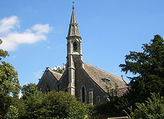
Parish church of St. Michael & All Angels
 Clifton Hampden
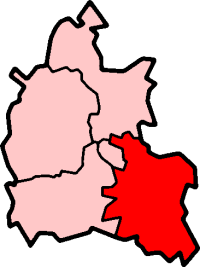
Clifton Hampden shown within OxfordshirePopulation 641 (parish, including Burcot) (2001 census)[1] OS grid reference SU5495 Parish Clifton Hampden District South Oxfordshire Shire county Oxfordshire Region South East Country England Sovereign state United Kingdom Post town Abingdon Postcode district OX14 Dialling code 01235 Police Thames Valley Fire Oxfordshire Ambulance South Central EU Parliament South East England UK Parliament Henley Website Clifton Hampden in Oxfordshire List of places: UK • England • Oxfordshire Clifton Hampden is a village and civil parish on the north bank of the River Thames, just over 3 miles (4.8 km) east of Abingdon in Oxfordshire. Since 1932 the civil parish has included the village of Burcot, 1 mile (1.6 km) east of Clifton Hampden.[2]
Contents
Manor
The toponym was originally simply "Clifton", meaning "tun on a cliff" in Old English. There is no documentation for the "Hampden" part of the name from before 1726.[2]
In the Anglo-Saxon era Clifton belonged to the Bishop of Dorchester. After the Norman conquest of England William the Conqueror transferred the see to Lincoln, with its properties including Clifton.[2]
Parish church
The Church of England parish church of St. Michael and All Angels was a chapel of Dorchester parish until the 19th century. The oldest parts of the church include the arcade of the south aisle, which was built in about 1180. Elsewhere in the church are three lancet windows from the 13th century in the Early English style. The south aisle ends in a chapel which was added in the 14th century in the Decorated style. The arcade of the north aisle is later, in the Perpendicular style. In 1844 Sir George Gilbert Scott rebuilt the church, ornamenting the chancel as a memorial to the benefactor who funded the restoration.[3]
Economic and social history
By the early part of the 13th century the parish was being farmed with an open field system. In the 15th century it was a three-field system and the fields were called East, Down and Ham. In 1726 the same fields were called Upper, Middle and Lower, respectively. The land was inclosed in 1770.[2]
From at least the early part of the 14th century there was a ferry across the Thames between the village and Long Wittenham.[2]
 Thatched cottages at Clifton Hampden.
Several cottages in the village survive from the later part of the 16th and early part of the 17th centuries. By 1726 the village had three public houses. By 1786 there was one called the Fleur de Lys, and this was still in business by 1864. The Plough beside Abingdon Road was a public house by 1821;[2] it still trades under the same name but is now a restaurant.
In 1736 the Parliament passed the first of several Acts to turn the main road between Abingdon and Dorchester into a turnpike. The section through Clifton Hampden ceased to be a turnpike in 1873.[2] In 1922 the Ministry of Transport classified it as the A415 road. In 1928, Oxfordshire County Council built a new bridge for the A415 beside the 15th century one.
In 1822, the Thames Navigation Commissioners built the 0.5 miles (800 m) long Clifton Cut, a navigation that bypasses a shallow and difficult stretch of river.[2] It ends with Clifton Lock, 0.5 miles (800 m) above Clifton Hampden ferry. In 1867, the ferry was replaced by Clifton Hampden Bridge, a brick structure designed by Sir G.G. Scott.[4] This was a toll bridge until 1946, when Berkshire and Oxfordshire county councils took it over. The Barley Mow just on the far side of Clifton Hampden Bridge is in Long Wittenham parish. In 1889, the author Jerome K. Jerome featured the village and the Barley Mow, in his book Three Men in a Boat:[5]
Round Clifton Hampden, itself a wonderfully pretty village, old-fashioned, peaceful, and dainty with flowers, the river scenery is rich and beautiful. If you stay the night on land at Clifton, you cannot do better than put up at the "Barley Mow."In 1844, the Great Western Railway opened an extension from Didcot to Oxford. The GWR opened a station on the main road between the village and Culham. The station is closest to Clifton Hampden but it is in Culham parish and the GWR called it Culham.
The Church of England school was built in 1847 and affiliated to the National Society for Promoting Religious Education. It had only one schoolroom until 1909, when an infants' room was added. In 1934 the school was reorganised as a junior school, with senior pupils being schooled in Dorchester. Since 1951 it has been a Church of England voluntary controlled primary school.[6]
The village hall was built in 1896.[2] It was in this hall that Radiohead use to pracise when they first came together, at which point they were first known as 'On A Friday'.
RNAS Culham
In 1941,[2] the Fleet Air Arm opened Royal Naval Air Station, HMS Hornbill, between Culham railway station and Clifton Hampden village. Most of the airfield is in Clifton Hampden parish, but HMS Hornbill was generally called RNAS Culham. The Admiralty closed the airfield in 1956[2] and transferred it to the UK Atomic Energy Authority in 1960. The former airfield is now the Culham Science Centre,[7] an 800,000 square metre scientific research site that includes two nuclear fusion experiments: JET and MAST. The START Nuclear Fusion Experiment was also conducted on the site until MAST succeeded it in 1999.
Amenities
Clifton Hampden has a village shop and post office[8] and a GPs' practice,[9] Clifton Hampden and Burcot, Oxfordshire|Burcot have a Women's Institute.[10]
Clifton Hampden Cricket Club plays in Oxfordshire Cricket Association Division Three.[11] The village also has a longbow archery society.[12]
A pedigree herd of alpacas, the Lost City Alpacas, is kept at the village.[13]
References
- ^ "Area: Clifton Hampden CP (Parish): Parish Headcounts". Neighbourhood Statistics. Office for National Statistics. http://neighbourhood.statistics.gov.uk/dissemination/LeadTableView.do?a=7&b=798636&c=Clifton+Hampden&d=16&e=15&g=480989&i=1001x1003x1004&o=1&m=0&r=1&s=1268756902703&enc=1&dsFamilyId=779. Retrieved 16 March 2010.
- ^ a b c d e f g h i j k Lobel, Mary, 1962, p. 27
- ^ Sherwood & Pevsner, 1974, page 549
- ^ Phillips, Geoffrey (1981). Thames Crossings. David and Charles. p. 65. ISBN 0715382020.
- ^ Jerome, Jerome K. (1889). Three Men in a Boat (To Say Nothing of the Dog). J. W. Arrowsmith. ISBN 0-7653-4161-1.
- ^ "Clifton Hampden Church of England Primary School". Clifton-hampden.oxon.sch.uk. http://www.clifton-hampden.oxon.sch.uk/. Retrieved 2010-10-09.
- ^ "Culham Science Centre". Culham.org.uk. http://www.culham.org.uk/. Retrieved 2010-10-09.
- ^ "Clifton Hampden Stores". Clifton Hampden Stores. http://www.cliftonhampdenstores.com/. Retrieved 2010-10-09.
- ^ "Clifton Hampden Surgery". Clifton Hampden Surgery. 2010-08-31. http://www.cliftonhampdensurgery.co.uk/. Retrieved 2010-10-09.
- ^ "Oxfordshire Federation of Women's Institutes". Oxfordshirefwi.freeuk.com. http://www.oxfordshirefwi.freeuk.com/. Retrieved 2010-10-09.
- ^ "Oxfordshire Cricket Association". Oxfordshire Cricket Association. http://www.oxfordshirecricketassociation.org.uk/tables/tables.asp?Division=3. Retrieved 2010-10-09.
- ^ "Clifton Hampden Longbow Society". Clifton Hampden Longbow Society. 2009-10-11. http://www.cliftonhampdenlongbowsociety.co.uk/. Retrieved 2010-10-09.
- ^ Lost City Alpacas, UK.
Sources
- Lobel, Mary (ed.) (1962). Victoria County History: A History of the County of Oxford: Volume 7: Dorchester and Thame hundreds. pp. 27–39.
- Sherwood, Jennifer; Pevsner, Nikolaus (1974). The Buildings of England: Oxfordshire. Harmondsworth: Penguin Books. pp. 549–550. ISBN 0 14 071045 0.
External links
 Media related to Clifton Hampden at Wikimedia CommonsCategories:
- Villages in Oxfordshire
- Populated places on the River Thames
- Civil parishes in Oxfordshire


Wikimedia Foundation. 2010.