Mugdock Country Park

Mugdock Country Park
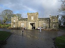
Visitor centre at Mugdock Country Park, in the former stables of Craigend Castle

Mugdock Country Park is a country park and historical site located partly in East Dunbartonshire and partly in Stirling, in the former county of Stirlingshire, Scotland. It is to the north of Glasgow, next to Milngavie.

The park includes the remains of the 14th-century Mugdock Castle, stronghold of the Grahams of Montrose, and the ruins of the 19th century Craigend Castle, a Gothic Revival mansion. The park has a moot hill and gallowhill, historical reminders of the baronial feudal right, held by lairds, of 'pit and gallows'. Natural features include the Allander Water, Mugdock Loch, and Drumclog Muir. Visitor facilities include a visitor centre and cafe in the former Craigend Castle stable block, and a garden centre in the walled garden.

External links

See also

Coordinates: 55°58′N 4°19′W / 55.967°N 4.317°W / 55.967; -4.317


Wikimedia Foundation. 2010.

Игры ⚽ Поможем сделать НИР

Look at other dictionaries:

  • Mugdock Castle — Strathblane, Scotland NS550772 …   Wikipedia

  • Loch Lomond and the Trossachs National Park — Infobox protected area | name = Loch Lomond and The Trossachs National Park iucn category = II caption = Looking eastwards along Loch Katrine in the Loch Lomond and the Trossachs National Park locator x = locator y = location = Scotland, Argyll… …   Wikipedia

  • Wild Country (film) — Infobox Film name = Wild Country image size = caption = director = Craig Strachan producer = Ros Borland writer = Craig Strachan narrator = starring = Martin Compston Peter Capaldi music = cinematography = Jan Pester editing = Colin Monie… …   Wikipedia

  • Milngavie water treatment works — Craigmaddie reservoir, empty during redevelopment works. Milngavie water treatment works is the primary source of the water for the city of Glasgow (and the Greater Glasgow area) in western Scotland. Part of the Victorian Loch Katrine water… …   Wikipedia

  • Strathblane — infobox UK place country = Scotland official name= Strathblane gaelic name= Strath Bhlàthain scots name= population= 1,811 (2001 Census) population density= Pop density km2 to mi2|54|precision=0|abbr=yes|wiki=yes area total sq mi= 17 os grid… …   Wikipedia

  • Liste des châteaux écossais — Cette liste non exhaustive répertorie les principaux châteaux en Écosse, au Royaume Uni. Elle inclut les châteaux au sens large du terme, c est à dire : les châteaux et châteaux forts (généralement bâtis en milieu rural, y compris… …   Wikipédia en Français

  • Craigend Castle — The ruins of Craigend Castle in Mugdock Country Park Craigend Castle is a ruined country house, located to the north of Milngavie, in East Dunbartonshire, central Scotland. The lands of Craigend were part of the Barony of Mugdock in medieval… …   Wikipedia

  • Sir Hugh Fraser, 2nd Baronet — Otherpeople|Hugh FraserSir Hugh Fraser, 2nd Baronet (18 September 1936 ndash; 5 May 1987), formerly 2nd Baron Fraser of Allander, was chairman of the House of Fraser, Harrods, George Outram (company), and Whyte and Mackay. He lived at Mugdock… …   Wikipedia

  • West Highland Way — Infobox Hiking trail Name=West Highland Way Photo=WHW Rannoch Moor.jpg Caption=The sun breaks partially through the clouds in a rainy day on the outskirt of Rannoch Moor in late April 2008 on West Highland Way on the way from Bridge of Orchy to… …   Wikipedia

  • List of places in East Dunbartonshire — This List of places in East Dunbartonshire is a list of links for any town, village, hamlet, golf course, historic house, nature reserve, reservoir, river, canal and other place of interest in East Dunbartonshire, Scotland, UK.compactTOC NOTOC… …   Wikipedia

Share the article and excerpts

Direct link
Do a right-click on the link above
and select “Copy Link”