Mount Bonython

Mount Bonython
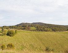
The summit from the north; Mount Lofty is behind to the right

Mount Bonython (34°58′S 138°42′E / 34.967°S 138.7°E / -34.967; 138.7, 682 m (2,238 ft) above sea level[1]) is one of two major peaks in the Adelaide hills visible from Adelaide. The other, about a kilometre to the south and some 20 m higher, is Mount Lofty. There is a telecommunications tower used for the Telstra NextG network located at its summit.[2]

According to the mythology of the indigenous Kaurna people, the Mount Lofty Ranges were part of the story of the ancestor-creator Nganno. Nganno travelled across the land of the Kaurna and after being wounded in a battle, lay down to die and formed the Mount Lofty Ranges. The current name of the Greater Mount Lofty Parklands, Yurrebilla, is taken from the Kaurna name for the twin hills of Mount Lofty and Mount Bonython, which are supposed to be Nganno's ears.

References

  1. ^ Peak elevation from Google Earth; location at Google Maps
  2. ^ Telstra NextG Towers in Australia


Wikimedia Foundation. 2010.

Игры ⚽ Поможем написать реферат

Look at other dictionaries:

  • Mount Remarkable National Park — IUCN Category II (National Park) …   Wikipedia

  • Bonython, Australian Capital Territory — Infobox Australian Place | type = suburb name = Bonython state = Australian Capital Territory city = Canberra caption = lga = Tuggeranong postcode = 2905 est = 1989 propval = AU$346,000 (2005) pop = 3,362 (2006 census) ACTgov = Brindabella fedgov …   Wikipedia

  • John Lavington Bonython — This article is about Sir John Lavington Bonython (1875 1960) His father was named Sir John Langdon Bonython (1848 1939) His son was named John Langdon Bonython (1905–1992) Sir John Lavington Bonython John Lavington Bonython, Mayor of Adelaide,… …   Wikipedia

  • List of mountains in Australia — This list is incomplete; you can help by expanding it. See also: List of mountains: Australia. This is a list of mountains in Australia. These are some of the highest mountains in Australia Contents 1 Highest point in each State/Territory …   Wikipedia

  • Waterfall Gully, South Australia — Infobox Australian Place | type = suburb name = Waterfall Gully city = Adelaide state = sa caption = First Falls, Waterfall Gully est = 1867 lga = City of Burnside postcode = 5066 pop = 2,285 (2001 census) (includes other suburbs) area = 6.08… …   Wikipedia

  • Waterfall Gully — Der Wasserfall von Waterfall Gully Staat …   Deutsch Wikipedia

  • Uraidla, South Australia — Infobox Australian Place | type = town name = Uraidla state = South Australia caption = Uraidla Township lga = Adelaide Hills Council postcode = 5142 est = 1880s pop = 442 (2001 census) elevation= maxtemp = mintemp = rainfall = stategov = Heysen… …   Wikipedia

  • Vulkathunha-Gammon Ranges National Park — The Gammon Ranges are part of the northern Flinders Ranges, immediately southwest of and adjacent to Arkaroola Sanctuary. They encompass some of the most rugged and spectacular country in South Australia.GeographyThe central ranges are of a… …   Wikipedia

  • Peramangk — The Peramangk were an Indigenous Australian people whose traditional lands were primarily located in Adelaide Hills but also in the southern stretches of the Fleurieu Peninsula, South Australia. They were also referred to as the Mount Barker… …   Wikipedia

  • Cornish Australian — Cornish Australians Ostralyon Kernow …   Wikipedia

Share the article and excerpts

Direct link
Do a right-click on the link above
and select “Copy Link”