- Cheakamus River
-
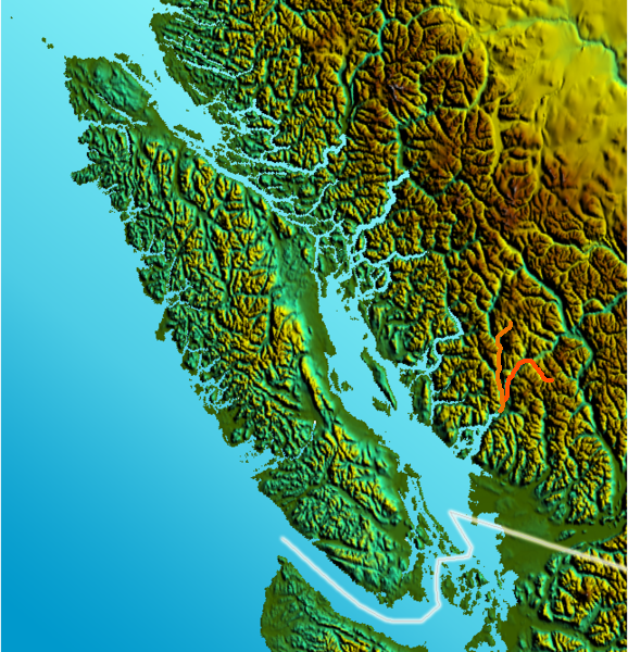
Cheakamus River River Country Canada Province British Columbia Source Outlier Peak - location Garibaldi Provincial Park, Coast Mountains - elevation 1,880 m (6,168 ft) [1] - coordinates 49°57′N 122°45′W / 49.95°N 122.75°W [2] Mouth Squamish River - elevation 18 m (59 ft) [1] - coordinates 49°47′N 123°10′W / 49.783°N 123.167°W [2] Length 70 km (43 mi) Basin 1,070 km2 (413 sq mi) [3] 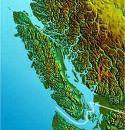 Location map of Cheakamus River; Squamish River shown in orange.
The Cheakamus River (pron. CHEK-a-moose) is a tributary of the Squamish River, beginning on the west slopes of Outlier Peak in Garibaldi Provincial Park upstream from Cheakamus Lake on the southeastern outskirts of the resort area of Whistler. The river flows into Cheakamus Lake before exiting it and flowing northwest until it turns south and enters Daisy Lake. Between the outlet of Daisy Lake and its mouth, much of its length is spent going through Cheakamus Canyon, where the river flows through swift rapids and even one good sized waterfall. The river flows south from the lake and through the canyon before joining the Squamish River at Cheekye, a few miles north of the town of Squamish. The river's name is an anglicization of the name of Chiyakmesh ("people of the fish weir"), a village of the Skwxwu7mesh people and a reserve of the Squamish Nation.
The c. 70 km (c.44 mi) length of the Cheakamus is followed by British Columbia Highway 99 (the Sea-to-Sky Highway and the British Columbia Railway. The Cheakamus is a whitewater rafting and kayaking route, and is known for its steelhead and salmon fishing. Much of the flow of the upper Cheakamus is diverted from Daisy Lake beneath the mountains to the west to the Cheakamus Powerhouse on the Squamish River. Notable just north of Daisy Lake is Brandywine Falls. The Nordic events complex of the 2010 Winter Olympics is to be located on Callaghan Creek, a tributary of the Cheakamus just upstream from Brandywine Creek.
Contents
Largest Tributaries
- Callaghan Creek
- Brandywine Creek
- Cheekye River
Cheakamus River derailment
Main article: Cheakamus River derailmentOn August 5, 2005, a long Canadian National train, heading inland from Brackendale, derailed and nine empty lumber flat cars along with one tank car of sodium hydroxide crashed off the main bridge, falling into the river. The tank car spilled its contents into the river, killing an estimated 500,000+ fish.[4] Six years, a local Vancouver News channel reported on the return of the fish to the river. Stay tuned...
See also
- The Barrier
- Cheakamus Valley basalts
- List of British Columbia rivers
- Mount Cayley volcanic field
References
- ^ a b Calculated with Google Earth
- ^ a b "Cheakamus River". BC Geographical Names. http://apps.gov.bc.ca/pub/bcgnws/names/4978.html.
- ^ "Cheakamus Project Water Use Plan" (PDF). BC Hydro. 2005. http://www.bchydro.com/rx_files/environment/environment41676.pdf. Retrieved September 3, 2008.
- ^ "B.C. river's recovery from spill could take decades". CBC News. 2006-02-07. http://www.cbc.ca/canada/story/2006/02/07/cheakamus-report060207.html. Retrieved 2006-07-19.
Categories:- Canyons and gorges of British Columbia
- Rivers of British Columbia
- Sea to Sky Country
- Rivers used for whitewater recreation
- Pacific Ranges
- New Westminster Land District
Wikimedia Foundation. 2010.