- Dolores Hidalgo
-
Dolores Hidalgo (in full, Dolores Hidalgo Cuna de la Independencia Nacional (English: Dolores Hidalgo Cradle of National Independence) is the name of a city and the surrounding municipality in the north-central part of the Mexican state of Guanajuato.
It is located at 21°10′N 100°56′W / 21.17°N 100.93°W, at an elevation of about 1,980 meters (6,480 feet) above sea level. In the census of 2005 the city had a population of 54,843 people, while the municipality had 134,641 inhabitants. The city lies directly in the center of the municipality, which is 1,590 km² (613.9 sq mi) in area and includes numerous small outlying communities, the largest of which is Río Laja.
Dolores Hidalgo was named a Pueblo Mágico (Magic Town) in 2002.
Contents
History
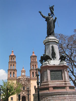 Church and the Statue of Hidalgo
The city was a small town known simply as Dolores when Father Miguel Hidalgo uttered his famous cry for the independence of Mexico (the Grito de Dolores) there in the early hours of September 16, 1810, in front of his parish church. After Mexico achieved independence, the town was renamed Dolores Hidalgo in his honor. On September 28, 1810, Hidalgo's forces killed more than 500 Spaniard and Creole loyalist soldiers during the battle for Dolores; 2,000 Indigenous Mexicans died in the fighting. Today Dolores Hidalgo is known primarily for its ceramics industry, which provides income to well over half the city's population. The inexpensive and mass-produced output of the town is marketed throughout Latin America and the United States. The central square of the town, in front of Fr Hidalgo's historic church, is a popular tourist spot.
 Tomb of José Alfredo Jiménez
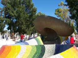
Another place of pilgrimage in Dolores Hidalgo, this time for fans of ranchera and popular music, is the tomb of José Alfredo Jiménez, one of the country's most beloved singers and songwriters, as well as one of the most prolific popular songwriters in the history of western music. He is buried in the town cemetery. Also footballer Adolfo "El Bofo" Bautista and Agustin Palomares were born here.
Twinned Cities
 Lexington, Massachusetts, United States of America.
 Mexico City, Mexico.
- Morelia, Michoacán, Mexico.
- San Marcos, Texas, United States of America.
References
- Link to tables of population data from Census of 2005 INEGI: Instituto Nacional de Estadística, Geografía e Informática
- Guanajuato Enciclopedia de los Municipios de México
External links
- Dolores Hidalgo Cuna de la Independencia Nacional Official website
- San Luis De La Paz, Guanajuato Nearby colonial town.
- Dolores Hidalgo eGuide to Dolores Hidalgo
- Bibliography and Hemerography: Miguel Hidalgo and Costilla.
- Miguel Hidalgo and Costilla - Documents of 1810 and 1811.
- Chronology of Miguel Hidalgo and Costilla.
Guanajuato, Gto. (capital) Municipalities Abasolo · Acámbaro · San Miguel de Allende · Apaseo el Alto · Apaseo el Grande · Atarjea · Celaya · Manuel Doblado · Comonfort · Coroneo · Cortázar · Cuerámaro · Doctor Mora · Dolores Hidalgo · Guanajuato · Huanímaro · Irapuato · Jaral del Progreso · Jerécuaro · León · Moroleón · Ocampo · Pénjamo · Pueblo Nuevo · Purísima del Rincón · Romita · Salamanca · Salvatierra · San Diego de la Unión · San Felipe · San Francisco del Rincón · San José Iturbide · San Luis de la Paz · Santa Catarina · Santa Cruz de Juventino Rosas · Santiago Maravatío · Silao · Tarandacuao · Tarimoro · Tierra Blanca · Uriangato · Valle de Santiago · Victoria · Villagrán · Xichú · Yuriria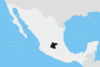 Categories:
- Populated places in Guanajuato
- Municipalities of Guanajuato


Wikimedia Foundation. 2010.