- Martin Hussingtree
-
Coordinates: 52°14′23″N 2°10′23″W / 52.239611°N 2.17318°W
Martin Hussingtree 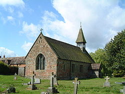
St Michael & All Angels, Martin Hussingtree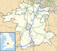
 Martin Hussingtree
Martin Hussingtree shown within WorcestershireOS grid reference SO882601 District Wychavon Shire county Worcestershire Region West Midlands Country England Sovereign state United Kingdom Post town WORCESTER Postcode district WR3 Dialling code 01905 Police West Mercia Fire Hereford and Worcester Ambulance West Midlands EU Parliament West Midlands List of places: UK • England • Worcestershire Martin Hussingtree is a small village situated between Droitwich Spa and Worcester in the county of Worcestershire, England. It is north of another village called Fernhill Heath. It is situated on a junction of the A38 and A4538. There is a public house called "The Swan" in the village and is located just north of the junction.
Its church contains the grave of Thomas Tomkins, a composer of sacred music under Elizabeth I and James I.
External links
Categories:- Villages in Worcestershire
- Wychavon
- Civil parishes in Worcestershire
- Worcestershire geography stubs


Wikimedia Foundation. 2010.