- Norwood Memorial Airport
-
For the airport in Norwood, Ontario, see Norwood Airport.
Norwood Memorial Airport 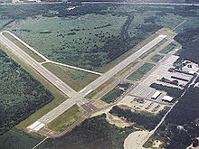
IATA: OWD – ICAO: KOWD – FAA LID: OWD Summary Airport type Public Owner Town of Norwood Location Norwood, Massachusetts Elevation AMSL 49 ft / 15 m Coordinates 42°11′26″N 071°10′23″W / 42.19056°N 71.17306°W Website Runways Direction Length Surface ft m 10/28 3,995 1,218 Asphalt 17/35 4,008 1,222 Asphalt Statistics (2006) Aircraft operations 100,000 Based aircraft 246 Source: Federal Aviation Administration[1] Norwood Memorial Airport (IATA: OWD, FAA LID: OWD, GPS code: KOWD)[2] is a public-use airport located two miles (3 km) east of the central business district of Norwood, a town in Norfolk County, Massachusetts, United States. This airport is owned by the Town of Norwood.[1] Located off Route 128, it is home to the offices of prominent local businessmen and several maintenance facilities.
Contents
Facilities and aircraft
Norwood Memorial Airport covers an area of 688 acres (278 ha) and has two runways:[1]
- Runway 10/28: 3,995 x 75 ft (1,218 x 23 m), Surface: Asphalt
- Runway 17/35: 4,008 x 100 ft (1,222 x 30 m), Surface: Asphalt
For the 12-month period ending January 1, 2006, the airport had 100,000 aircraft operations, an average of 273 per day: 77% general aviation, 22% air taxi and 1% military.[1]
There are 246 aircraft based at this airport: 81% single engine, 12% multi-engine, 4% jet aircraft and 2% helicopters.[1]
The airport also includes two flight schools and Flight Level Aviation as an FBO. Charter services operate commonly out of the airport.
Incidents
On June 4, 2007 a Mooney M-20-P crashed into the woods south of the airport while on final approach. One person was killed.[3]
In March 2010, the airport was closed due to severe flooding.[4]
References
- ^ a b c d e FAA Airport Master Record for OWD (Form 5010 PDF), effective 2007-03-15
- ^ List of ICAO codes. The US DoD DAFIF agrees on assigning no ICAO code to Norwood. For the IATA code, see List of IATA codes.
- ^ "Woman killed in plane crash near Norwood Airport". WBZ NewsRadio 1030. 2007-06-04. http://www.wbz.com/pages/539555.php?contentType=4&contentId=573353.
- ^ "DOT: Norwood Airport a flooding risk". Norwood Transcript and Bulletin. 15 March 2010. http://www.wickedlocal.com/norwood/news/x99750375/DOT-Norwood-Airport-a-flooding-risk. Retrieved 3 January 2011.
External links
- Norwood Memorial Airport (official site)
- Flight Level Norwood
- FAA Airport Diagram (PDF), effective 20 October 2011
- Resources for this airport:
- AirNav airport information for KOWD
- ASN accident history for OWD
- FlightAware airport information and live flight tracker
- NOAA/NWS latest weather observations
- SkyVector aeronautical chart, Terminal Procedures for KOWD
Categories:- Airports in Massachusetts
- Transportation in Norfolk County, Massachusetts
- Buildings and structures in Norfolk County, Massachusetts
- Norwood, Massachusetts
- Massachusetts building and structure stubs
- Northeastern United States airport stubs

Wikimedia Foundation. 2010.