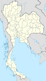
- Doi Inthanon
-
Doi Inthanon 
Napapon Phoom-siri Chedi - dedicated to the Queen of Thailand commemorating her 60th birthday in 1992) near the summit of Doi InthanonElevation 2,565 m (8,415 ft) Prominence 1,850 m (6,070 ft) Listing Country high point
UltraLocation Chiang Mai (  Thailand)
Range Shan Hills Coordinates 18°35′32″N 98°29′12″E / 18.59222°N 98.48667°ECoordinates: 18°35′32″N 98°29′12″E / 18.59222°N 98.48667°E Geology Type granite batholith Climbing Easiest route drive Doi Inthanon (Thai: ดอยอินทนนท์(Pronunciation)) is the highest mountain in Thailand. It is located in Mae Chaem District. The mountain was also known in the past as Doi Luang (meaning big mountain) or Doi Ang Ka, meaning the crow's pond top. Near the mountain's base was a pond where many crows gathered. The name Doi Inthanon was given in honour of the king Inthawichayanon, one of the last kings of Chiang Mai, who was concerned about the forests in the north and tried to preserve them. He ordered that after his death his remains shall be placed at Doi Luang, which was then renamed.
Contents
Geography
Doi Inthanon is part of a mountain range separating Burma from Thailand also known as Loi Lar Mountain Range or Daen Lao Range. This range, the westernmost of the Shan Highland system, separates the Salween watershed from the Mekong watershed. Other high peaks of the Loi Lar Mountain Range are Doi Luang Chiang Dao (2,175 m), Doi Pui (1,685 m), and Doi Suthep (1,601 m).
In 1954, the forests around Doi Inthanon were preserved, creating Doi Inthanon National Park, as one of the original 14 National parks of Thailand. It covers 482.40 km². The park spreads from the lowlands at 800 m altitude up to the peak in 2565 m, thus covering many climatic and ecological different parts, thus with a total of 362 it has the second highest number of bird species of any national park in Thailand.
On the lower slope of Doi Inthanon, near the Karen hill tribe village Ban Sop Had, are the Wachirathan waterfalls (Thai: น้ำตกวชิรธาร), where the Wachirathan (lit. "Diamond Creek") tumbles over a granite escarpment.18°32′30″N 98°35′57″E / 18.541790°N 98.599247°E
Napamaytanidol Chedi
On the main road to the summit of Doi Inthanon stand the two Napamaytanidol Chedi. These temples were built to honor the 60th birthday of the King and Queen in 1987 and 1992 respectively.
Geology
Geologically the mountain is a granite batholith in a north-south oriented mountain range. The second-highest peak of this range is Doi Hua Mod Luang at 2,340 m.
See also
- List of mountains in Thailand
- List of Southeast Asian mountains
References
Gallery
External links
Categories:- Mountains of Thailand
- Chiang Mai Province
Wikimedia Foundation. 2010.


