- Cornholme
-
Coordinates: 53°43′59″N 2°08′49″W / 53.733°N 2.147°W
Cornholme 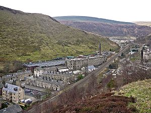
Cornholme, 2009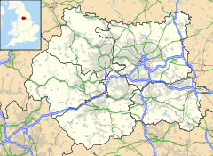
 Cornholme
Cornholme shown within West YorkshireOS grid reference SD904263 Parish Todmorden Metropolitan borough Calderdale Metropolitan county West Yorkshire Region Yorkshire and the Humber Country England Sovereign state United Kingdom Post town TODMORDEN Postcode district OL14 Dialling code 01706 Police West Yorkshire Fire West Yorkshire Ambulance Yorkshire EU Parliament Yorkshire and the Humber UK Parliament Calder Valley List of places: UK • England • Yorkshire Cornholme is a village within the Metropolitan Borough of Calderdale, in West Yorkshire, England. It lies at the edge of Calderdale, on the boundary with Lancashire, and in the narrow Calder Valley about 2.5 miles (4 km) northwest of Todmorden.
Cornholme was historically a part of Lancashire, the former principal industries of most of the Upper Calder Valley being cotton weaving and the manufacture of textile accessories such as shuttles and bobbins. The village became part of the West Riding of Yorkshire on 1 January 1888 and part of the Borough of Todmorden, within the West Riding, on 2 June 1896.
It is home to Cornholme J, I and N (Junior, Infant and Nursery) School. One of the pupils there describes Cornholme as full of history and legend. Cornholme School itself, despite being over 100 years old, is still one of the youngest in the area!
The Gem, whose name lives on in an electrical goods store, was once a cinema, in pre-television days. There are no cinemas in Cornholme today.
Cornholme is the location of a number of scenes in the 2004 film 'My Summer of Love'.
Picture Archives of the Cornholme area and the school can be found at the following addresses
Todmorden History and The History Section
External links
 Media related to Cornholme at Wikimedia CommonsCategories:
- Villages in West Yorkshire
- Geography of Calderdale
- West Yorkshire geography stubs


Wikimedia Foundation. 2010.