- Panna District
-
This article is about the district. For its eponymous headquarters, see Panna, India.
Panna district
पन्ना जिला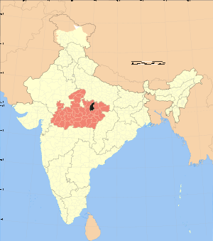
Location of Panna district in Madhya PradeshState Madhya Pradesh,  India
IndiaAdministrative division Sagar Headquarters Panna, India Area 7,135 km2 (2,755 sq mi) Population 854,235 (2001) Population density 120 /km2 (310 /sq mi) Sex ratio 907 Lok Sabha Constituencies Khajuraho Major highways NH 75 Official website Panna district is a district of the Sagar Division, within the Madhya Pradesh state in central India. The town of Panna is the district headquarter.
Contents
History
Panna District was created in 1950, shortly after Indian independence, from the territory of several former princely states of British India, including the states of Panna, Jaso, most of Ajaigarh, and a portion of Paldeo. Panna District was part of the new Indian state of Vindhya Pradesh, which was merged into Madhya Pradesh on November 1, 1956.
Geography
Panna district lies between 23º 45' and 25º 10' north latitudes and 79º 45' and 80º 40' east longitudes.[1] It has an area of 7,135 km2.[2]
The Ken River flows through the district. The Pandav Falls and the Gatha Falls are located in the district. Panna National Park is a major tourist attraction in the district.[3]
Economy
In 2006 the Ministry of Panchayati Raj named Panna one of the country's 250 most backward districts (out of a total of 640).[4] It is one of the 24 districts in Madhya Pradesh currently receiving funds from the Backward Regions Grant Fund Programme (BRGF).[4]
Divisions
Gram panchayats under Panna district
This intermediate subdivisions are also called block,[5] intermediate panchayat,[6] tehsil[7] or tahsil.[7] Inside Panna district, there are the following five subdivisions:
- Ajaigarh;
- Gunour (or Gunnor, or Gunor as panchayat and habitation name[5] or Gunaur as village name[5]);
- Panna;
- Pawai;
- Shahnagar
Demographics
According to the 2011 census Panna District has a population of 1,016,028,[8] roughly equal to the nation of Cyprus[9] or the US state of Montana.[10] This gives it a ranking of 442nd in India (out of a total of 640).[8] The district has a population density of 142 inhabitants per square kilometre (370 /sq mi) .[8] Its population growth rate over the decade 2001-2011 was 18.62 %.[8] Panna has a sex ratio of 907 females for every 1000 males,[8] and a literacy rate of 66.08 %.[8]
Languages
Among Panna's languages is Bagheli, which has a lexical similarity of 72-91% with Hindi[11] (compared to 60% for German and English)[12] and is spoken by about 7 800 000 people in Bagelkhand;[11] and Bharia, a Dravidian language spoken by at least 200 000 members of the Bharia tribe and written in the Devanagari script.[13]
Economy
Panna district is famous for its diamond mines located in a belt of about 80 km across the Panna town.[2] In olden days the most productive mines were located in the village of Sukariuh.[14] Nowadays, Majhagaon is the only active diamond mine in Asia.[15]
References
- ^ "Panna district map". Maps of India. http://www.mapsofindia.com/maps/madhyapradesh/districts/panna.htm. Retrieved 2010-08-18.
- ^ a b "Panna District". india9. http://www.india9.com/i9show/Panna-District-13757.htm. Retrieved 2010-08-18.
- ^ "Panna – a city of diamonds". Panna district administration. http://www.panna.nic.in/. Retrieved 2010-08-18.
- ^ a b Ministry of Panchayati Raj (September 8, 2009). "A Note on the Backward Regions Grant Fund Programme". National Institute of Rural Development. http://www.nird.org.in/brgf/doc/brgf_BackgroundNote.pdf. Retrieved September 27, 2011.
- ^ a b c National Habitation Survey 2003: LIST OF QUALITY AFFECTED HABITATIONS
- ^ Village Panchayat Names of AJAIGARH
- ^ a b State elections 2008 candidates
- ^ a b c d e f "District Census 2011". Census2011.co.in. 2011. http://www.census2011.co.in/district.php. Retrieved 2011-09-30.
- ^ US Directorate of Intelligence. "Country Comparison:Population". https://www.cia.gov/library/publications/the-world-factbook/rankorder/2119rank.html. Retrieved 2011-10-01. "Cyprus 1,120,489 July 2011 est."
- ^ "2010 Resident Population Data". U. S. Census Bureau. http://2010.census.gov/2010census/data/apportionment-pop-text.php. Retrieved 2011-09-30. "Montana 989,415"
- ^ a b M. Paul Lewis, ed (2009). "Bagheli: A language of India". Ethnologue: Languages of the World (16th edition ed.). Dallas, Texas: SIL International. http://www.ethnologue.com/show_language.asp?code=bfy. Retrieved 2011-09-28.
- ^ M. Paul Lewis, ed (2009). "English". Ethnologue: Languages of the World (16th edition ed.). Dallas, Texas: SIL International. http://www.ethnologue.com/show_language.asp?code=eng. Retrieved 2011-09-28.
- ^ M. Paul Lewis, ed (2009). "Bharia: A language of India". Ethnologue: Languages of the World (16th edition ed.). Dallas, Texas: SIL International. http://www.ethnologue.com/show_language.asp?code=bha. Retrieved 2011-09-28.
- ^ Streeter, Edwin W.. "Precious stones and Gems". The Indian Diamond. George Bell & Sons (1898). http://www.farlang.com/gemstones/streeter-precious-stones/page_146. Retrieved 2010-08-18.
- ^ "Panna Diamond Mines". Subh Yatra. http://www.shubhyatra.com/madhya-pradesh/panna-diamond-mines.html. Retrieved 2010-08-18.
External links

Chhatarpur district Banda district, Uttar Pradesh 
Satna district  Panna district

Damoh district Katni district Divisions & Districts of Madhya Pradesh · 
Bhopal Division: Chambal Division: Gwalior Division: Ashoknagar · Datia · Guna · Gwalior · Shivpuri
Indore Division: Jabalpur Division: Narmadapuram Division: Betul · Harda · Hoshangabad
Rewa Division: Sagar Division: Chhatarpur · Damoh · Panna · Sagar · Tikamgarh
Shahdol Division: Ujjain Division: Cities and towns in Sagar Division Chhatarpur district Bada Malhera • Barigarh • Bijawar • Buxwaha • Chandla • Chhatarpur • Garhi-Malhara • Ghuwara • Harpalpur • Laundi • Maharajpur • Nowgaon • Rajnagar • SataiDamoh district Panna district Sagar district Bina Etawa • Bina Railway Colony • Deori • Dhana • Garhakota • Khurai • Makronia • Mandi Bamora • Rahatgarh • Rehli • Sagar Cantonment • Sagar • Shahgarh • ShahpurTikamgarh district Badagaon • Baldeogarh • Jatara • Jeron Khalsa • Kari • Khargapur • Lidhorakhas • Niwari • Orchha • Palera • Prithvipur • Taricharkalan • TikamgarhRelated topics Categories:

Wikimedia Foundation. 2010.