- Engadin
-
See also: Engadine (disambiguation)
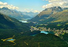 The lakes of the Upper Engadin and the town of St. Moritz
The Engadin or Engadine (German: Engadin, Italian: Engadina, Romansh: Engiadina; tr: garden of the Inn) is a long valley in the Swiss Alps located in the canton of Graubünden in southeast Switzerland. It follows the route of the Inn River from its headwaters at Maloja Pass running northeast until the Inn flows into Austria one hundred kilometers downstream. The Engadin is protected by high mountains on all sides and is famous for its sunny climate, beautiful landscapes and outdoor activities.
Contents
Etymology
In Romansch, which is the indigenous language of the region, the "Engadin" literally translates as the Inn Garden; the garden of the Inn River (Romansch: En). However, historically, politically and geographically, the Engadin refers to the entire region, including the Inn River Valley, its tributaries and the surrounding mountains.
Geography
 The highest peaks of the eastern Alps are in the Bernina range
The Engadin valley lies at the centre of the Alpine range and constitutes the upper part of the 300 km-long Inn valley. From the Maloja Pass (1,815 m) to the border to Tyrol (1,000 m) north of Vinadi the valley runs for a length of 100 km, always above 1,000 metres in elevation. The highest mountains of the valley are in the Bernina Range in the upper part.
The Engadin is divided into two parts:
- The Upper Engadin from Maloja to Zernez, where the valley is remarkably straight and wide, and up to S-chanf, fairly flat
- The Lower Engadine from Zernez to the Austrian border, where the Inn drops more quickly and its path is more tortuous
Upper Engadin
The Upper Engadin begins at the Maloja mountain pass with a chain of lakes running north-east–south-west: Lej da Segl (Lake Sils), famous for windsurfing, Lej da Silvaplauna (Lake Silvaplana), and Lej da San Murezzan (Lake St. Moritz). At the south-west end of the valley, the Maloja Pass drops precipitously down to Chiavenna in Italy through the Val Bregaglia, and thence to Como. At the Lunghin Pass, above Maloja, lies the most notable triple watershed in western Europe, from where the Inn flows via the Danube to the Black Sea, the Maira via the Po to the Mediterranean Sea, and the Julia via the Rhine to the North Sea.
The resort of St. Moritz (1,800 m) sits on Lej da San Murezzan. It was the host city for the 1928 and 1948 Winter Olympics. There are numerous ski resorts in the area served by the ski areas of Piz Corvatsch and Piz Nair.
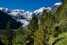
 Val Roseg, south of Pontresina
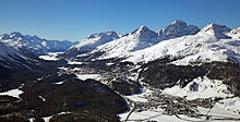 View of the High Engadin valley from Muottas Muragl.
Northeast of St. Moritz lies the village of Samedan, which is the capital of the Upper Engadin. Near Samedan, the river Flaz joins the Inn and the valley opens into a wide meadow framed with mountains. The Flaz is a major tributary which flows down the valley leading to the Bernina Pass (2,323 m). The highest mountain in the Engadin – and in the Eastern Alps – is Piz Bernina, which is 4,049 m and is located nearby.
Below Samedan are a number of villages lying on the banks of the Inn. Perhaps the best preserved is Zuoz (1,720 m), which is a beautiful village of typical Engadin houses, with large, thick stone and masonry walls, funnel-shaped windows and wall paintings called sgraffito. These house are large and are often shared by two or more families, and they may have what used to be a stable or livestock area underneath. In a typical Engadin village, there are numerous fountains, free-flowing all year round, which were formerly used for drinking water, washing, and for watering livestock.
In the Upper Engadin there is a train from Samedan that connects via Albula tunnel with the rest of Switzerland. In the summer, Albula Pass is also open for car travel. The Julier Pass, above St. Moritz connects the Engadin with the rest of Graubünden.
Immediately below Zuoz is the village of S-chanf, which is the end of the large flat meadow surrounding the Inn. Every year there is a famous cross-country ski race called the Engadin Marathon from Maloja, across the frozen lakes and over the open meadows and ending in S-chanf. Thousands of skiers participate.
Below S-chanf the landscape suddenly changes. The Inn, now rather wild, flows through a deep gorge with steep walls and meadows give way to larch woods. At Zernez, the Inn valley open up again for a short distance. In Zernez (1,470 m) the Fuorn Pass goes south, passing through the Swiss National Park.
Lower Engadin
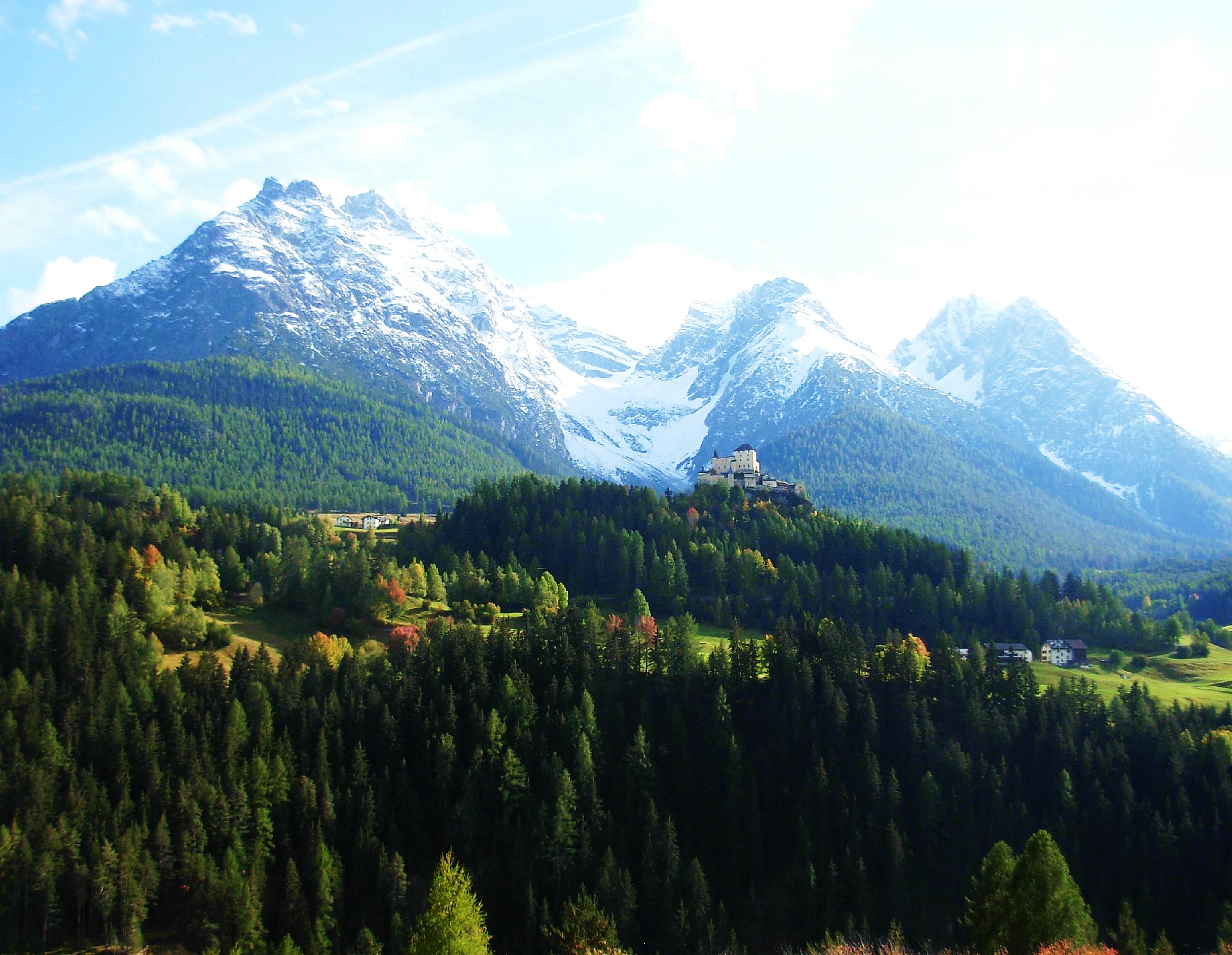
 Tarasp Castle, Lower Engadin
Just above Zernez, at the Punt Ota, the Lower Engadin begins. Here the villages are no longer located in the valley floor but higher up on sunny terraces formed in the glacial period.
To the north, another train route connects the Lower Engadin with Klosters via the recently built Vereina Tunnel. The capital of the Lower Engadin is the ski resort and spa Scuol (1,200 m).
Demographics
In the Upper Engadin, as a result of the influx of people related to tourism, the number of Romansch and Swiss-German speakers are about equal, and in the heavily touristed village of St. Moritz there are few Romansch speakers. In the Lower Engadin, Romansch is still the most widely spoken language, but almost all of the people also speak German as a second language. Most place signs in both the Upper and Lower Engadin show both languages, e.g. St. Moritz - San Murezzan, Sils - Segl, Celerina - Schlarigna.
Lakes
Lake Area Elevation Lake Sils 4.1 km² 1797 m Lake Silvaplana 2.7 km² 1791 m Lake Champfèr Lake St. Moritz 0.78 km² 1768 m Traditions
Though no one knows how far back it dates, the traditional winter horse-drawn sleigh ride takes place every winter. Many of the sleighs used come from local families who have been living in the area over many generations. The fact that their carriages go as far back as they do, helps to identify the tradition as one that has possibly been around for centuries.
The Schlittéda (“sleigh ride”- the word Schlittenfahrt has an equivalent meaning) is composed of many sleighs, each carrying a young woman and a young man paired up by a lottery, and one sleigh carrying a musician or group of musicians to serenade the riders and the accompanying audience.
Typical black and red Engadine dress is used by the townspeople and the horses are decorated with plumage and trimmings in addition to the bells. Throughout the day-long ride, stops, that have been planned ahead of time, are made where eating, dancing, and drinking occur. At the end of the night, the girl’s male pair is invited home with the girl for more celebratory eating.
External links
- Engadin in Romansh, German, French and Italian in the online Historical Dictionary of Switzerland.
- Culture archive of the Engadin
- www.engadin.stmoritz.ch
- Engadin pictures - Photos of the Engadin
- Webcams of the Engadin
- Vegetation map Upper Engadine, 1:50'000, GIS, june 2010 ISBN 978-3-033-02480-9
Coordinates: 46°32′59″N 9°53′45″E / 46.5497°N 9.8959°E
Maloja • Sils/Segl • Silvaplana • Champfèr • St. Moritz • Celerina/Schlarigna • Pontresina • Samedan • Bever • La Punt • Chamues-ch • Madulain • Zuoz • S-chanf • Zernez • Susch • Lavin • Guarda • Ardez • Tarasp-Vulpera • Ftan • Scuol • Sent • Ramosch • Tschlin • MartinaCategories:- Engadin
- Regions of Switzerland
- Valleys of the Alps
- Valleys of Graubünden


Wikimedia Foundation. 2010.