- Thunder Bay Expressway
-
Thunder Bay Expressway
Part of Terry Fox Courage Highway
Ontario Highway 7250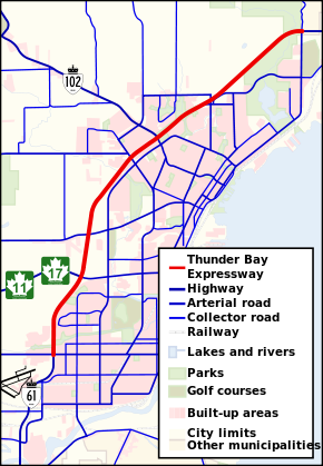
Route information Maintained by MTO Length: 15.3 km (9.5 mi) Major junctions south end:  Highway 61
 Highway 11 / Highway 17 (west)
Harbour Expressway (east)
 Highway 102 (west)
Red River Road (east)east end: Highway 11 / Highway 17Highway system The Thunder Bay Expressway is a four lane highway with signalized intersections running on the western edge of Thunder Bay, Ontario, Canada.
Route description
During construction in the 1970s, the road had the temporary designation of Highway 131 (which was later recycled for a highway near Barrie, Ontario).
The Thunder Bay Expressway has the unsigned designation of Highway 7250 and forms the southernmost portion of the Terry Fox Courage Highway, which continues east to Nipigon along the Trans-Canada Highway[1]. Between Arthur Street and the Harbour Expressway, it shares a designation with Ontario highway 61. Between the Harbour Expressway and its eastern terminus at Hodder Avenue, it shares a designation with highways 11 and 17, a portion of the Trans-Canada Highway.
The entire route is four lanes and undivided, with an exception between Balsam Street and Hodder Avenue where the route is twinned. Its intersections are all at-grade. Plans to entirely twin the highway and build interchanges were abandoned in the 1990s. The city of Thunder Bay maintains a right of way for these expansion plans in its official plan, and in some places there is evidence of these plans. However, the province of Ontario has recently announced funding to twin the Trans-Canada Highway from Thunder Bay to Nipigon. This should bring long-awaited upgrades to the expressway.
The highway runs along the western edge of Thunder Bay south and bisects the northwest portion of Thunder Bay north. The bulk of its traffic is local but it is also an important route in the Trans-Canada highway network.
List of intersections
The following is a list of intersections on the Thunder Bay Expressway. The intersections on the expressway are unnumbered.
km Intersecting road(s) Notes 0.0 Arthur Street North as Highway 61 3.0 East: Highway 11/17 (Shabaqua Highway) (Trans-Canada)
West: Harbour ExpresswayHighway 61 designation ends
Highway 11/17 (Trans-Canada) designation begins4.6 Oliver Road 7.7 John Street 8.9 East: Red River Road
West: Dawson RoadDawson Road becomes Highway 102 at Strand Avenue, 300m west. 10.9 Huron Avenue One-way off-ramp, eastbound. 11.2 Balsam Street Highway is divided between km 11.6 and 15.2 15.3 North: Copenhagen Road
South: Hodder AvenueThunder Bay Expressway designation ends. Highway 11/17 and Terry Fox Courage Highway designations continue. AADT 2004
Location AADT Chippewa Rd.to Broadway Ave. 10,000 Broadway Ave. to Neebing Ave./ Princess St. 13,200 Neebing Ave./ Princess St. to Arthur St. 16,900 Arthur St. to Harbour Expressway/ Highway 11/17 22,100 Harbour Expressway/ Highway 11/17 to Oliver Rd. 17,400 Oliver Rd. to John St. 18.000 John St. to Red River Rd./ Highway 102 (Dawson Rd.) 15,500 Red River Rd./ Highway 102 (Dawson Rd.) to Balsam St. 12,800 Balsam St. to Hodder Ave./Copenhagen Rd. 7,850 Categories:- Roads in Thunder Bay
- Urban segments of the Trans-Canada Highway
- Orbital roads in Canada

Wikimedia Foundation. 2010.